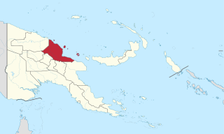
Madang is a province of Papua New Guinea. The province is on the northern coast of mainland Papua New Guinea and has many of the country's highest peaks, active volcanoes and its biggest mix of languages. The capital is the town of Madang.
Madang is the capital of Madang Province and is a town with a population of 27,420 on the north coast of Papua New Guinea. It was first settled by the Germans in the 19th century.

Chimbu, more frequently spelled Simbu, is a province in the Highlands Region of Papua New Guinea. The province has an area of 6,112 km2 and a population of 376,473. The capital of the province is Kundiawa. Mount Wilhelm, the tallest mountain in Papua New Guinea is on the border of Eastern part of Simbu and the Western part of Madang Province.

Morobe Province is a province on the northern coast of Papua New Guinea. The provincial capital and largest city is Lae. The province covers 33,705 km2, with a population of 674,810, and since the division of Southern Highlands Province in May 2012 it is the most populous province. It includes the Huon Peninsula, the Markham River, and delta, and coastal territories along the Huon Gulf. The province has nine administrative districts. At least 101 languages are spoken, including Kâte and Yabem language. English and Tok Pisin are common languages in the urban areas, and in some areas pidgin forms of German are mixed with the native language.

Astrolabe Bay is a large body of water off the south coast of Madang Province, Papua New Guinea, located at 5.35°S 145.9166667°E. It is a part of the Bismarck Sea and stretches from the Cape Iris in the south to the Cape Croisilles to the north. It was discovered in 1827 by Jules Dumont d'Urville and named after his ship. Capital of Madang Province, Madang lies on the coast of Astrolabe Bay.

This page is a list of districts of Papua New Guinea.
For administrative purposes, Papua New Guinea (PNG) is divided into administrative divisions called regions and provinces. Papua New Guinea is divided into four regions and 22 province-level divisions: 20 provinces plus the autonomous region (Bougainville) and the National Capital District.
Watiwa is a Rai Coast language of Papua New Guinea.
Bogia District is a district in the north-west of Madang Province in Papua New Guinea. It is one of the six administrative districts that make up the province.
Bogadjim is a village on Astrolabe Bay, just south of Madang, in Astrolabe Bay Rural LLG, Madang Province, Papua New Guinea. During World War II, the Japanese started to build a track from Bogadjim over the Finisterre Mountains into the Ramu Valley and the village became an important base.
Mauwake (Mawake), or Ulingan, is a Papuan language spoken in Almami Rural LLG, Madang Province, Papua New Guinea. It is spoken in several villages along the north coast of Madang province, which lies in the north-east of Papua New Guinea.
Siroi (Suroi) is a Rai Coast language spoken in Madang Province, Papua New Guinea, and a local trade language. It is spoken in Kumisanger village, Astrolabe Bay Rural LLG, Madang Province.
Nankinian is one of the Finisterre languages of Papua New Guinea. Nankina Wam, Domung Meh, and Yupno Gen. are related varieties.
Danaru is a Rai Coast language of Papua New Guinea. It is spoken in the single village of Danaru in Usino Rural LLG, Madang Province, Papua New Guinea.
Sam, or Songum, is a Madang language spoken in Madang Province, Papua New Guinea.
Ronji is a minor Austronesian language of northern Papua New Guinea.
Saidor is a village located in Saidor ward of Rai Coast Rural LLG, Madang Province, on the north coast of Papua New Guinea.
Astrolabe Bay Rural LLG is a local-level government (LLG) of Madang Province, Papua New Guinea.
Rai Coast Rural LLG is a local-level government (LLG) of Madang Province, Papua New Guinea.
Yamben (Yaben) is a Trans–New Guinea language of Madang Province, Papua New Guinea. It was first documented by Andrew Pick in the 2010s and classified by Pick (2019) as a probable primary branch of Madang, though its precise classification is still pending further research. Although surrounded by Croisilles languages, Yamben is not one of them.
