
An aviation accident is defined by the Convention on International Civil Aviation Annex 13 as an occurrence associated with the operation of an aircraft, which takes place from the time any person boards the aircraft with the intention of flight until all such persons have disembarked, and in which (a) a person is fatally or seriously injured, (b) the aircraft sustains significant damage or structural failure, or (c) the aircraft goes missing or becomes completely inaccessible. Annex 13 defines an aviation incident as an occurrence, other than an accident, associated with the operation of an aircraft that affects or could affect the safety of operation.

Phnom Penh International Airport is the busiest airport in Cambodia and serves as the country's main international gateway. It is Cambodia's second largest airport by area after the new Siem Reap–Angkor International Airport. It is located in the Pou Senchey District, 10 kilometres (5.4 NM) west of Phnom Penh, the nation's capital.
President Airlines was an airline based in Phnom Penh, Cambodia. It was privately owned and operated scheduled passenger flights from Phnom Penh to domestic destinations, as well as flights to Thailand, China and Hong Kong out of Phnom Penh International Airport.

Siem Reap Airways International was a Cambodian regional airline based in Phnom Penh, Cambodia. Wholly owned by Bangkok Airways of Thailand, its primary hub was Phnom Penh International Airport, with secondary hubs at Suvarnabhumi Airport and Siem Reap International Airport. It ceased operations in 1 December 2008.

Siem Reap International Airport was an international airport serving Siem Reap and Angkor. It opened in 1932 and closed in 2023 upon the opening of Siem Reap–Angkor International Airport. It was the second-busiest airport in Cambodia after Phnom Penh International Airport.
PMTair was a Cambodian airline offering regularly scheduled domestic and international passenger and cargo services out of Phnom Penh International Airport.

Pakistan Civil Aviation Authority (PCAA) is a state-owned autonomous body under the administrative control of the Secretary to the Government of Pakistan for Aviation, which oversees and regulates all aspects of civil aviation in Pakistan. PCAA's head office is situated in Terminal-1 of Jinnah International Airport in Karachi. PCAA is a member state of the International Civil Aviation Organization. Nearly all 44 civilian airports in Pakistan are owned and operated by the PCAA.
Tingo María Airport is an airport serving Tingo María, in the Huánuco Region of Peru. The runway is alongside the west bank of the Huallaga River.
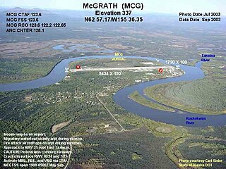
McGrath Airport is a state-owned public-use airport serving McGrath, a city in the Yukon-Koyukuk Census Area of the U.S. state of Alaska.
Kampuchea Airlines was an airline based in Phnom Penh, Cambodia, operating regional passenger services out of Phnom Penh International Airport.

Sihanouk International Airport, located 20 kilometres (12 mi) east of Sihanoukville City in Sihanoukville Province, is Cambodia's third largest international airport. It is named, like the province itself, after King Norodom Sihanouk. The airport is also known as Kang Keng Airport. The IATA code KOS is derived from Sihanoukville's alternative name "Kampong Som".

Timbuktu Airport is an airport in Timbuktu, Mali that opened on April 15, 1961.

Progress Multi Trade Air Flight 241 was a scheduled domestic passenger flight from Siem Reap to Sihanoukville, Cambodia. The flight was operated by regional airliner PMTair using an Antonov An-24. On 25 June 2007, the Antonov An-24, registered as XU-U4A, disappeared over the Cambodian jungle near Bokor Mountain in Kampot while on approach to Sihanoukville. A massive search and rescue operation ensued with thousands of soldiers and police scoured the area. The aircraft was found to have crashed in southwestern Cambodia, northeast of Dâmrei Mountains. All 22 people on board, most of whom were South Korean tourists, were killed. It remains as the second deadliest air disaster in Cambodian history.

Ka Choung is a waterfall in Ratanakiri province in Cambodia. The falls are located in Ban Lung District about 7 kilometres north west of the provincial capital Banlung.

Vietnam Airlines Flight 815 was a scheduled Vietnam Airlines flight which crashed on final approach to Pochentong International Airport in Cambodia on 3 September 1997. The Soviet-built Tupolev Tu-134B-3 airliner crashed approximately 800 metres short of the Phnom Penh runway, killing 65 of the 66 people on board. As of February 2024, it remains the deadliest accident in Cambodian history. Upon investigation, the crash was determined to have been the result of improper actions by the pilot.
Rock County Airport is a public use airport located two nautical miles southwest of the central business district of Bassett, a city in Rock County, Nebraska, United States. It is owned by the Rock County Airport Authority. According to the FAA's National Plan of Integrated Airport Systems for 2009–2013, it is classified as a general aviation airport.
The State Secretariat of Civil Aviation is an agency of the government of Cambodia in-charge of civil aviation including airports in the country. It is headquartered in the capital Phnom Penh. The SSCA oversees the operation of national airports and air traffic management system in Cambodia. In 2000, it granted lease to SAMART Corporation to operate and upgrade the country's air traffic control and air navigation system under a long-term concession. The Secretary of State in charge is Mao Havannall.
Paramakatoi Airport is an airport serving the village of Paramakatoi, in the Potaro-Siparuni Region of Guyana.
