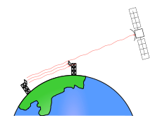
Imagery intelligence (IMINT), pronounced as either as Im-Int or I-Mint, is an intelligence gathering discipline wherein imagery is analyzed to identify information of intelligence value. Imagery used for defense intelligence purposes is generally collected via satellite imagery or aerial photography.

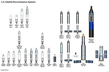
The Corona program was a series of American strategic reconnaissance satellites produced and operated by the Central Intelligence Agency (CIA) Directorate of Science & Technology with substantial assistance from the U.S. Air Force. The CORONA satellites were used for photographic surveillance of the Soviet Union (USSR), China, and other areas beginning in June 1959 and ending in May 1972.

The National Reconnaissance Office (NRO) is a member of the United States Intelligence Community and an agency of the United States Department of Defense which designs, builds, launches, and operates the reconnaissance satellites of the U.S. federal government. It provides satellite intelligence to several government agencies, particularly signals intelligence (SIGINT) to the NSA, imagery intelligence (IMINT) to the NGA, and measurement and signature intelligence (MASINT) to the DIA. The NRO announced in 2023 that it plans within the following decade to quadruple the number of satellites it operates and increase the number of signals and images it delivers by a factor of ten.

BYEMAN codenamed GAMBIT, the KH-7 was a reconnaissance satellite used by the United States from July 1963 to June 1967. Like the older CORONA system, it acquired imagery intelligence by taking photographs and returning the undeveloped film to earth. It achieved a typical ground-resolution of 2 ft (0.61 m) to 3 ft (0.91 m). Though most of the imagery from the KH-7 satellites was declassified in 2002, details of the satellite program remained classified until 2011.

The KH-8 was a long-lived series of reconnaissance satellites of the "Key Hole" (KH) series used by the United States from July 1966 to April 1984, and also known as Low Altitude Surveillance Platform. The satellite ejected "film-bucket" canisters of photographic film that were retrieved as they descended through the atmosphere by parachute. Ground resolution of the mature satellite system was better than 4 inches (0.10 m). There were 54 launch attempts of the 3,000 kilogram satellites, all from Vandenberg Air Force Base, on variants of the Titan III rocket. Three launches failed to achieve orbit. The first one was satellite #5 on April 26, 1967, which fell into the Pacific Ocean after the Titan second stage developed low thrust. The second was satellite #35 on May 20, 1972, which suffered an Agena pneumatic regulator failure and reentered the atmosphere. A few months later, pieces of the satellite turned up in England and the US managed to arrange for their hasty return. The third failure was satellite #39 on June 26, 1973, which suffered a stuck Agena fuel valve. The Bell 8096 engine failed to start and the satellite burned up in the atmosphere. The KH-8 was manufactured by Lockheed. The camera system/satellite was manufactured by Eastman Kodak's A&O Division in Rochester, New York.
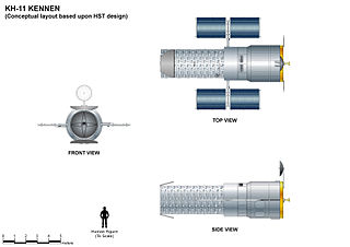
The KH-11 KENNEN is a type of reconnaissance satellite first launched by the American National Reconnaissance Office (NRO) in December 1976. Manufactured by Lockheed in Sunnyvale, California, the KH-11 was the first American spy satellite to use electro-optical digital imaging, and so offer real-time optical observations.

The SAMOS or SAMOS-E program was a relatively short-lived series of reconnaissance satellites for the United States in the early 1960s, also used as a cover for the initial development of the KH-7 GAMBIT system. Reconnaissance was performed with film cameras and television surveillance from polar low Earth orbits with film canister returns and transmittals over the United States. SAMOS was first launched in 1960 from Vandenberg Air Force Base.

Lacrosse or Onyx was a series of terrestrial radar imaging reconnaissance satellites operated by the United States National Reconnaissance Office (NRO). While not officially confirmed by the NRO or the Government of the United States prior to 2008, there was widespread evidence pointing to its existence, including one NASA website. In July 2008, the NRO itself declassified the existence of its synthetic aperture radar (SAR) satellite constellation.

Satellite images are images of Earth collected by imaging satellites operated by governments and businesses around the world. Satellite imaging companies sell images by licensing them to governments and businesses such as Apple Maps and Google Maps.
Lockheed Martin Space is one of the four major business divisions of Lockheed Martin. It has its headquarters in Littleton, Colorado, with additional sites in Valley Forge, Pennsylvania; Sunnyvale, California; Santa Cruz, California; Huntsville, Alabama; and elsewhere in the United States and United Kingdom. The division currently employs about 20,000 people, and its most notable products are commercial and military satellites, space probes, missile defense systems, NASA's Orion spacecraft, and the Space Shuttle external tank.

Galactic Radiation and Background (GRAB) was the first successful United States orbital surveillance program, comprising a series of five Naval Research Laboratory electronic surveillance and solar astronomy satellites, launched from 1960 to 1962. Though only two of the five satellites made it into orbit, they returned a wealth of information on Soviet air defense radar capabilities as well as useful astronomical observations of the Sun.
Future Imagery Architecture (FIA) was a program awarded to Boeing to design a new generation of optical and radar imaging US reconnaissance satellites for the National Reconnaissance Office (NRO). In 2005 NRO director Donald Kerr recommended the project's termination, and the optical component of the program was finally cancelled in September 2005 by Director of National Intelligence John Negroponte. FIA has been called by The New York Times "perhaps the most spectacular and expensive failure in the 50-year history of American spy satellite projects." Despite the optical component's cancellation, the radar component, known as Topaz, has continued, with four satellites in orbit as of February 2016.
Thor was a US space launch vehicle derived from the PGM-17 Thor intermediate-range ballistic missile. The Thor rocket was the first member of the Delta rocket family of space launch vehicles. The last launch of a direct derivative of the Thor missile occurred in 2018 as the first stage of the final Delta II.

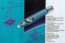
KH-9, commonly known as Big Bird or KeyHole-9, was a series of photographic reconnaissance satellites launched by the United States between 1971 and 1986. Of twenty launch attempts by the National Reconnaissance Office, all but one were successful. Photographic film aboard the KH-9 was sent back to Earth in recoverable film return capsules for processing and interpretation. The highest ground resolution achieved by the main cameras of the satellite was 2 ft (0.61 m), though another source says "images in the "better-than-one-foot" category" for the last "Gambit" missions.
Discoverer 1 was the first of a series of satellites which were part of the CORONA reconnaissance satellite program. It was launched on a Thor-Agena A rocket on 28 February 1959 at 21:49:16 GMT from Vandenberg Air Force Base in California. It was a prototype of the KH-1 satellite, but did not contain either a camera or a film capsule. It was the first satellite launched toward the South Pole in an attempt to achieve a polar orbit, but was unsuccessful. A CIA report, later declassified, concluded that "Today, most people believe the Discoverer 1 landed somewhere near the South Pole".
Electro-optical MASINT is a subdiscipline of Measurement and Signature Intelligence, (MASINT) and refers to intelligence gathering activities which bring together disparate elements that do not fit within the definitions of Signals Intelligence (SIGINT), Imagery Intelligence (IMINT), or Human Intelligence (HUMINT).

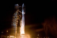
USA-193, also known as NRO Launch 21, was a United States military reconnaissance satellite launched on 14 December 2006. It was the first launch conducted by the United Launch Alliance (ULA). Owned by the National Reconnaissance Office (NRO), the craft's precise function and purpose were classified. On 21 February 2008, it was destroyed as a result of Operation Burnt Frost.
USA-247, also known as NRO Launch 39 or NROL-39, is an American reconnaissance satellite, operated by the National Reconnaissance Office and launched in December 2013. The USA-247 launch received a relatively high level of press coverage due to the mission's choice of logo, which depicts an octopus sitting astride the globe with the motto "Nothing Is Beyond Our Reach". The logo was extensively criticized in light of the surveillance disclosures in July 2013.

Discoverer 4, also known as Corona 9001, was an American optical reconnaissance satellite launched on 25 Jun 1959 at 22:47:45 GMT, the first of ten operational flights of the Corona KH-1 spy satellite series, and the first satellite to be equipped for photo surveillance. The satellite was not successfully orbited. Its loss spurred improvements of its rocket booster to ensure the success of subsequent missions.
While the United States Space Force gained its independence on 20 December 2019, the history of the United States Space Force can be traced back to the beginnings of the military space program following the conclusion of the Second World War in 1945. Early military space development was begun within the United States Army Air Forces by General Henry H. Arnold, who identified space as a crucial military arena decades before the first spaceflight. Gaining its independence from the Army on 18 September 1947, the United States Air Force began development of military space and ballistic missile programs, while also competing with the United States Army and United States Navy for the space mission.