Red Springs, North Carolina

Last updated

Red Springs
Red Springs, NC.jpg
Main Street
NCMap-doton-RedSprings.PNG
Location within the state of North Carolina
Coordinates: 34°48′17″N79°10′56″W / 34.80472°N 79.18222°W / 34.80472; -79.18222
Country United States
State North Carolina
Counties Robeson
Government
  MayorEd Henderson
Area
[1]
  Total3.67 sq mi (9.50 km2)
  Land3.50 sq mi (9.07 km2)
  Water0.17 sq mi (0.44 km2)
Elevation
[2]
200 ft (60 m)
Population
 (2020)
  Total3,087
  Density882.00/sq mi (340.50/km2)
Time zone UTC-5 (Eastern (EST))
  Summer (DST) UTC-4 (EDT)
ZIP code
28377
Area codes 910, 472
FIPS code 37-55660 [3]
GNIS feature ID2407187 [2]
Website www.redsprings.org

Red Springs is a town in Robeson County in the U.S. state of North Carolina. [4] The population was 3,428 at the 2010 census. [5]

Contents

Geography

Red Springs is located in northern Robeson County. North Carolina Highways 211 and 71 are the main roads through the town, joining to form North Main Street. NC-211 leads north 12 miles (19 km) to Raeford and southeast 18 miles (29 km) to Lumberton, while NC-71 leads northeast 8 miles (13 km) to Lumber Bridge and southwest 12 miles (19 km) to Maxton. North Carolina Highway 72 leaves Red Springs on South Main Street, leading south via Philadelphus 19 miles (31 km) to Lumberton.

According to the United States Census Bureau, the town of Red Springs has a total area of 3.7 square miles (9.5 km2), of which 3.5 square miles (9.1 km2) are land and 0.2 square miles (0.4 km2), or 4.61%, are water bodies. [5]

History

One of the first settlers in this community was "Sailor Hector" McNeill. It is not known exactly how he got his nickname, but he is found using it in the Bladen County tax lists of 1771. [6] (Red Springs is in Robeson County which was formed from Bladen County in 1787.) "Sailor Hector" McNeill's home was at the top of the hill on the edge of the McNeill cemetery in town, and he and his wife Mary are buried there in unmarked graves. [7] In 1775, McNeill secured a royal land grant from King George III for the area encompassing the eventual town. [8] The 1795 Mill Prong house was built nearby in Hoke County and uses a Red Springs address.

Red Springs, 1915 Red Springs, 1915.jpg
Red Springs, 1915

In the mid-1800s the community served as a summer resort, with visitors attracted to its mineral springs. By around 1852, Malcolm McNiell, Hector's grandson, had established a hotel to serve vacationers. It remained in operation until another hotel was built by S. R. Townsend in 1891. [8] A line of the Cape Fear and Yadkin Valley Railway was laid through the community in June 1884, and at about that time a post office was opened under the name Dora. [9] The following year the name of the post office was changed to Red Springs [10] in homage to the rusty color of the spring water. [9] In 1887 the community was incorporated at the impetus of legislator Hamilton McMillan, a resident of the town. The following year the Scottish Chief newspaper was founded. It published there for several years before being moved to Maxton. [10] On February 17, 1906, a large section of the downtown was destroyed by fire. [9]

Between 1896 and 1915, Red Springs had a military school for boys as well as the Southern Conservatory of Music for girls from all over the country. The military school is long gone, but in time the conservatory became Flora McDonald College, known today as Flora McDonald Academy, a private day school. In the 1840s, Floral College for young women was established a few miles south of town by a local lawyer, John Gilchrist, Jr. of Mill Prong House. The school operated until the Civil War, reopened afterward, but closed its doors around 1870.

From 1947 to 1950, Red Springs fielded a professional minor league baseball team, the Red Springs Red Robins, that was a farm team of the Philadelphia Athletics. The team won the Tobacco State League championship in 1948. In 1949, led by pitcher Bill Harrington, who would go on to pitch for the big league parent club, the Red Robins won a second title. The 1950 team was led by player/manager Ducky Detweiler, who had played for the Boston Braves. [11]

Professional baseball returned to Red Springs in 1969 when Red Springs Twins played, as the Minnesota Twins organization moved its Class A franchise from Wilson, N.C. During the year the club drew more than 40,000 fans and were managed by Tom Umphlett, a former major leaguer and North Carolina native. Six future major Leaguers were on the Red Springs roster. The team lasted only one season and were featured in Sports Illustrated magazine. [12]

Demographics

Historical population
CensusPop.Note
1900 858
1910 1,08926.9%
1920 1,018−6.5%
1930 1,30027.7%
1940 1,55919.9%
1950 2,24544.0%
1960 2,76723.3%
1970 3,38322.3%
1980 3,6076.6%
1990 3,7995.3%
2000 3,493−8.1%
2010 3,428−1.9%
2020 3,087−9.9%
U.S. Decennial Census [13]

2020 census

Red Springs racial composition [14]
RaceNum.Perc.
White (non-Hispanic)78325.36%
Black or African American (non-Hispanic)1,31342.53%
Native American 44414.38%
Asian 80.26%
Pacific Islander 10.03%
Other/Mixed 1565.05%
Hispanic or Latino 38212.37%

As of the 2020 United States census, there were 3,087 people, 1,342 households, and 777 families residing in the town.

2000 census

As of the census [3] of 2000, there were 3,493 people, 1,320 households, and 893 families residing in the town. The population density was 1,233.0 inhabitants per square mile (476.1/km2). There were 1,458 housing units at an average density of 514.7 per square mile (198.7/km2). The racial makeup of the town was 38.19% White, 49.16% African American, 8.65% Native American, 0.34% Asian, 0.14% Pacific Islander, 2.32% from other races, and 1.20% from two or more races. Hispanic or Latino of any race were 3.66% of the population.

There were 1,320 households, out of which 28.0% had children under the age of 18 living with them, 38.5% were married couples living together, 23.6% had a female householder with no husband present, and 32.3% were non-families. 28.7% of all households were made up of individuals, and 15.2% had someone living alone who was 65 years of age or older. The average household size was 2.56 and the average family size was 3.10.

In the town, the population was spread out, with 26.0% under the age of 18, 9.0% from 18 to 24, 23.8% from 25 to 44, 22.8% from 45 to 64, and 18.3% who were 65 years of age or older. The median age was 38 years. For every 100 females, there were 82.1 males. For every 100 females age 18 and over, there were 81.8 males.

The median income for a household in the town was $24,194, and the median income for a family was $34,760. Males had a median income of $25,655 versus $18,974 for females. The per capita income for the town was $15,347. About 26.0% of families and 30.4% of the population were below the poverty line, including 50.6% of those under age 18 and 14.7% of those age 65 or over.

Related Research Articles

<span class="mw-page-title-main">Stanly County, North Carolina</span> County in North Carolina, United States

Stanly County is a county in the U.S. state of North Carolina. As of the 2020 census, the population was 62,504. Its county seat is Albemarle.

<span class="mw-page-title-main">Robeson County, North Carolina</span> County in North Carolina, United States

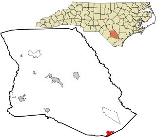
Robeson County is a county in the southern part of the U.S. state of North Carolina and is its largest county by land area. Its county seat and largest community is Lumberton. The county was formed in 1787 from part of Bladen County and named in honor of Thomas Robeson, a colonel who had led Patriot forces in the area during the Revolutionary War. As of the 2020 census, the county's population was 116,530. It is a majority-minority county; its residents are approximately 38 percent Native American, 22 percent white, 22 percent black, and 10 percent Hispanic. It is included in the Fayetteville-Lumberton-Pinehurst, NC Combined Statistical Area. The state-recognized Lumbee Tribe of North Carolina is headquartered in Pembroke.

<span class="mw-page-title-main">Pender County, North Carolina</span> County in North Carolina, United States

Pender County is a county located in the U.S. state of North Carolina. As of the 2020 census, the population was 60,203. Its county seat is Burgaw. Pender County is part of the Wilmington, NC Metropolitan Statistical Area.

<span class="mw-page-title-main">Cumberland County, North Carolina</span> County in North Carolina, United States

Cumberland County is a county located in the U.S. state of North Carolina. As of the 2020 census, the population was 334,728, making it the fifth-most populous county in North Carolina. Its county seat is Fayetteville. Cumberland County is part of the Fayetteville, NC Metropolitan Statistical Area.

<span class="mw-page-title-main">Anson County, North Carolina</span> County in North Carolina, United States

Anson County is a county located in the U.S. state of North Carolina. As of the 2020 census, the population was 22,055. Its county seat is Wadesboro.

<span class="mw-page-title-main">Bladenboro, North Carolina</span> Town in North Carolina, United States

Bladenboro is a town in Bladen County, North Carolina, United States. As of the 2010 census, the town population was 1,750.

<span class="mw-page-title-main">Butters, North Carolina</span> Census-designated place in North Carolina, United States

Butters is a census-designated place (CDP) in Bladen County, North Carolina, United States. As of the 2020 census, the population was 250.

<span class="mw-page-title-main">Clarkton, North Carolina</span> Town in North Carolina, United States

Clarkton is a town in Bladen County, North Carolina, United States. The population was 837 at the 2010 census.

<span class="mw-page-title-main">East Arcadia, North Carolina</span> Town in North Carolina, United States

East Arcadia is a town in Bladen County, North Carolina, United States. The population was 487 at the 2010 census.

<span class="mw-page-title-main">Elizabethtown, North Carolina</span> Town in North Carolina, United States

Elizabethtown is a town in Bladen County, North Carolina, United States. The population was 3,296 at the 2020 census. It is the county seat of Bladen County.

<span class="mw-page-title-main">Tar Heel, North Carolina</span> Town in North Carolina, United States

Tar Heel is a town located in Bladen County, North Carolina, United States. As of the 2010 census, the town population was 117.

<span class="mw-page-title-main">Angier, North Carolina</span> Town in North Carolina, United States

Angier is a town in the Black River Township of Harnett County, North Carolina, United States. The population was 4,350 at the 2010 census and estimated as of 2018 to be 5,253. Angier is a part of the greater Raleigh–Durham–Cary Combined Statistical Area (CSA) as defined by the United States Census Bureau.

Elrod is a census-designated place (CDP) in Robeson County, North Carolina, United States. The population was 441 at the 2000 census.

<span class="mw-page-title-main">Lumberton, North Carolina</span> City in North Carolina, United States

Lumberton is a city in Robeson County, North Carolina, United States. As of 2020, its population was 19,025. It is the seat of Robeson County's government.

<span class="mw-page-title-main">McDonald, North Carolina</span> Town in North Carolina, United States

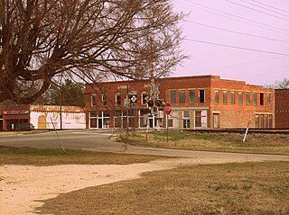
McDonald is a town in Robeson County, North Carolina, United States. The population was 113 at the 2010 census.

<span class="mw-page-title-main">Parkton, North Carolina</span> Town in North Carolina, United States

Parkton is a town in Robeson County, North Carolina, Lumberton metro area, United States. The town was so named because it was a place where farmers tied up their horses while waiting for the train. As of the 2020 census, the town population was 504.

Prospect is a census-designated place (CDP) in Robeson County, North Carolina, United States. The population was 690 at the 2000 census. Located due northeast of Pembroke, Prospect is a traditionally Methodist community, with its church members largely becoming representatives for the entirety of the American Indian-Methodist community. Prospect is noted for one of its native sons, Adolph Dial, whose contributions to American Indian Studies have led to an heightened awareness of the local Lumbee Tribe and Native Americans throughout the Southeastern United States.

<span class="mw-page-title-main">St. Pauls, North Carolina</span> Town in North Carolina, United States

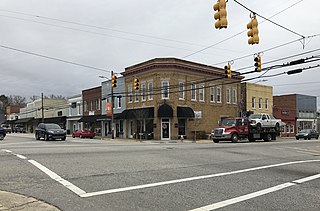
St. Pauls is a town in Robeson County, North Carolina, United States. The population was 2,035 at the 2010 census.

<span class="mw-page-title-main">Laurinburg, North Carolina</span> City in North Carolina, United States

Laurinburg is a city in and the county seat of Scotland County, North Carolina, United States. Located in southern North Carolina near the South Carolina border, Laurinburg is southwest of Fayetteville and is home to St. Andrews University. The population at the 2010 census was 15,962 people.

<span class="mw-page-title-main">Maxton, North Carolina</span> Town in North Carolina, United States

Maxton is a town in Robeson and Scotland counties, North Carolina, United States. The population was 2,426 at the time of the 2010 U.S. Census.

References

  1. "ArcGIS REST Services Directory". United States Census Bureau. Retrieved September 20, 2022.
  2. 1 2 U.S. Geological Survey Geographic Names Information System: Red Springs, North Carolina
  3. 1 2 "U.S. Census website". United States Census Bureau . Retrieved January 31, 2008.
  4. "Community Information". Town of Red Springs North Carolina. Retrieved October 9, 2023.
  5. 1 2 "Geographic Identifiers: 2010 Census Summary File 1 (G001): Red Springs town, North Carolina". American Factfinder. U.S. Census Bureau. Archived from the original on February 13, 2020. Retrieved December 21, 2017.
  6. Bladen County, North Carolina Tax Lists 1768 - 1774 Volume 1, page 59, by William Byrd III
  7. A History of Red Springs by Mrs. George Bullock, 1969.
  8. 1 2 Lawrence 1939, p. 22.
  9. 1 2 3 Tyner 2005, p. 18.
  10. 1 2 Lawrence 1939, p. 24.
  11. Holaday, Chris (2016). "The Tobacco State League; A North Carolina Baseball History, 1946–1950".. Jefferson, N.C.: McFarland. ISBN   978-1-4766-6670-9.
  12. S. I. Staff. "A bonanza in Red Springs". Sports Illustrated Vault | SI.com.
  13. "Census of Population and Housing". Census.gov. Retrieved June 4, 2015.
  14. "Explore Census Data". data.census.gov. Retrieved December 10, 2021.

Works cited