Redwood Empire Council

Last updated
Redwood Empire Council #041
Redwood Empire Council CSP.png
Old Redwood Empire Council CSP
Owner Boy Scouts of America
HeadquartersSanta Rosa, California
CountryUnited States
Founded1919
PresidentRay Leonard
Council CommissionerKeith Schoenthal
Scout ExecutiveCharles Howard-Gibbon
Website
Official website
WikiProject Scouting fleur-de-lis dark.svg  Scouting portal

Redwood Empire Council is the local council of the Boy Scouts of America that serves youth in Mendocino and Sonoma counties in California.

Contents

The Petaluma Area Council #041 (originally Petaluma Council) was founded in 1919, and served the cities/towns of Petaluma, Sonoma, Cotati, and adjacent unincorporated communities. In 1943, it expanded through a territory transfer with the Silverado Area Council (at this time adding Mendocino County and northern Sonoma County area). At that time, the PAC voted to rename itself the Sonoma-Mendocino Area Council.

The Redwood Area Council #044 was founded in 1923. [1] Following the recommendation of a 1991 Western Region council realignment study, the Redwood Area Council agreed to merge with the Sonoma-Mendocino Area Council in 1992, and at that time SMAC #041 added the board members of the RAC and voted to rename the larger council Redwood Empire Council.

In early 2012, Scouting in Humboldt and Del Norte Counties were reassigned to Crater Lake Council (Oregon), while Redwood Empire Council retained the Scouting programs in Sonoma and Mendocino Counties.

The Redwood Empire Council is celebrating its 2019 Centennial Year with a number of events throughout the year.

Organization

Camps

Camp Navarro (formerly Camp Masonite Navarro)

Camp Navarro
Location Mendocino County, California
Coordinates 39°10′8.52″N123°34′8.22″W / 39.1690333°N 123.5689500°W / 39.1690333; -123.5689500
Website
www.campnavarro.com

Camp Navarro is located near Navarro in Mendocino County, California.

Camp Navarro began as a lumber camp of the Albion Lumber Company. A spur of the Fort Bragg and Southeastern Railroad from Albion to the mill at Wendling (now Navarro) and Christine (now Floodgate) ran through the camp and up Neefus Creek. There was a "Y" for turning engines around that is still vaguely visible in camp, A piece of rail and large chain are also some railroad remnants that are displayed in front of the dining hall. Lumbering and the railroad stopped in the 1920s but notches cut in redwoods for springboards, can still be seen in the Mohawk campsite and outside of the staff shower area. Goosepens, circles of redwoods sprouted from the roots of cut trees, are throughout the camp. All but one of the portable buildings, built on skids to be moved from camp to camp have disappeared. The one that remains is used as a tool shed. Part of a water tank on skids can also be seen.

The camp was used as a Civilian Conservation Corps camp during the Depression, and as an army camp at the start of World War II. When acquired by Scouting it still had a row of decrepit plywood barracks along the river side of the parade ground. The lumber camp buildings on skids were used as Scout camp staff quarters for a number of years.

When Camp Navarro opened in 1956 the Adirondack shelters were built. Many of these same structures remain today. The current craft lodge is all that remains of the original dining hall. The foundation of a metal flagpole is still visible where the "55 Navarro Salute" cannon once stood. A wood-frame dam was erected on the North Fork of the Navarro River each summer to create a swimming area; in 1965 it gave way and the practice of building a gravel dam began. The gravel dam has not been built since 2001, however.

In late 1955, the land became the property of The Masonite Corporation. For 17 years, Masonite leased the camp to the Sonoma-Mendocino Area Council BSA for one dollar per year. Masonite sold Camp Navarro to the Sonoma-Mendocino Area Council on August 29, 1973, for one dollar, and it was renamed Camp Masonite Navarro. The camp offered a summer program for Cub Scouts that lasted four days.

In 2012, Redwood Empire Council sold Camp Masonite Navarro to Navarro Stewards LLC for $1.4 million, with the mortgage note carried by the council. Since 2001 environmental regulations prevented the damming of the North Fork of the Navarro River. Without a waterfront the camp was unable to attract Scouts to fill enough summer camp sessions to keep the camp solvent. As a result, the camp became a financial burden that caused the council to run a deficit and go into debt. The camp was sold, and the new owners returned to using the original name of Camp Navarro. The council carries the mortgage note for the new owners, so the financial obligation is not yet paid off.

Camp Noyo

Camp Noyo
Location Mendocino County, California
Coordinates 39°25′29.48″N123°36′41.22″W / 39.4248556°N 123.6114500°W / 39.4248556; -123.6114500
Website
http://www.redwoodbsa.org/Camping/Camp-Noyo/

Camp Noyo is a camp on the Noyo River in Mendocino County, California. The camp was opened by the Silverado Area Council in 1933 and transferred to the Sonoma-Mendocino Area Council in 1943. The SMAC, then later the Redwood Empire Council, offered a summer program for Boy Scouts that consisted of two to three one-week sessions.

In the late 1950s, the Scout summer camp program transferred to Camp Navarro, but Camp Noyo was still used for Explorer camps. The Scout summer camp program was restarted in 2009. In 2012, the camp was sold to the family of a former board member, and the family rents it back to the council for the weeks of Scout summer camp and weekend events.

The council holds Noyo Family Camp Adventure Weekend, a three-day camping adventure for Scout families, and two sessions of Scouts BSA summer camp, utilizing an all volunteer staff. Scouts and Scouters enter and leave the camp normally by riding the California Western Railroad "Skunk Train" which also runs along the Noyo River.

Order of the Arrow

Orca Lodge
HeadquartersSanta Rosa, California
LocationSonoma County, California
CountryUnited States
Founded1994
Website
http://www.orca194.org/

Orca Lodge 194 was formed from the merger of the Mow-A-Toc Lodge 262 (of the Redwood Area Council) and the Cabrosha Lodge 537 (of the Sonoma Mendocino Area Council).

The Orca Lodge consists of the three chapters, one for each of the council's districts. Orca Lodge has won several recognitions from the National Order of the Arrow, and is consistently earning recognition in the O.A. Journey to Excellence program.

See also

Related Research Articles

<span class="mw-page-title-main">Sonoma County, California</span> County in California, United States

Sonoma County is located in the U.S. state of California. As of the 2020 United States Census, its population was 488,863. Its seat of government and largest city is Santa Rosa.

<span class="mw-page-title-main">Scouting in California</span> Overview of Scouting in the State of California

Scouting in California has a long history, from the 1910s to the present day, serving thousands of youth in programs related to their environments.

<span class="mw-page-title-main">Scouting in Nevada</span> Scouting in Nevada

Scouting in Nevada has a long history, from the 1910s to the present day, serving thousands of youth in programs that suit the environment in which they live.

<span class="mw-page-title-main">Fort Bragg, California</span> City in California, United States

Fort Bragg is a city along the Pacific Coast of California along Shoreline Highway in Mendocino County. The city is 24 miles (39 km) west of Willits, at an elevation of 85 feet (26 m). Its population was 6,983 at the 2020 census.

<span class="mw-page-title-main">California Western Railroad</span> A heritage railroad in Mendocino County, California (USA), running from Fort Bragg to Willits

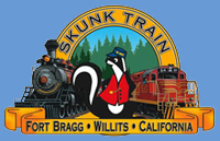
The California Western Railroad, AKA Mendocino Railway, popularly called the Skunk Train, is a rail freight and heritage railroad transport railway in Mendocino County, California, United States, running from the railroad's headquarters in the coastal town of Fort Bragg to the interchange with the Northwestern Pacific Railroad at Willits.

<span class="mw-page-title-main">Navarro River Redwoods State Park</span> State park in Mendocino County, California

Navarro River Redwoods State Park is a state park in Mendocino County, California, consisting of 660 acres (2.7 km2) of second-growth redwood forest in a narrow stretch 11 miles (18 km) long on both banks of the Navarro River, from the town of Navarro to the river's confluence with the Pacific Ocean.

<span class="mw-page-title-main">Hendy Woods State Park</span> Park in Mendocino County, California

Hendy Woods State Park is a California state park, located in the Anderson Valley of Mendocino County. It is known for its old-growth coast redwoods and also provides camping facilities near the wineries of the Anderson Valley. It is named after Joshua Hendy, who owned the land and stipulated that it be protected; it passed through several owners after Hendy without being logged, before becoming part of the California State Park system in 1958.

<span class="mw-page-title-main">Northwestern Pacific Railroad</span> Regional railroad in California, US

The Northwestern Pacific Railroad is a 271-mile (436 km) mainline railroad from the ferry connections in Sausalito, California north to Eureka with a connection to the national railroad system at Schellville. The railroad has gone through a history of different ownership and operators but has maintained a generic name of reference as The Northwestern Pacific Railroad, despite no longer being officially named that. Currently, only a 62-mile (100 km) stretch of mainline from Larkspur to the Sonoma County Airport in Windsor and east to Schellville on the “south end” is operated by Sonoma–Marin Area Rail Transit (SMART), which operates both commuter and freight trains with plans for future extension north to Cloverdale. The “north end” from Willits to Eureka is currently out of service, but saved by 2018 legislation to be converted into the Great Redwood Trail.

<span class="mw-page-title-main">Area codes 707 and 369</span> Area codes in northwestern California, United States

Area codes 707 and 369 are telephone area codes in the North American Numbering Plan (NANP) for the northwestern part of the U.S. state of California. The area codes serve part of the northern San Francisco Bay Area, as well as the North Coast. Major cities in the area codes include Napa, Sebastopol, Vallejo, Benicia, Fairfield, Santa Rosa, Windsor, Healdsburg, Rohnert Park, Petaluma, Fort Bragg, Rio Vista, Crescent City, Eureka, Clearlake, Vacaville, Dixon, and Ukiah. 707 was created by a split of area code 415 on March 1, 1959. Area code 369 was added to the numbering plan area (NPA) on February 1, 2023, to form an overlay numbering plan in the service area.

<span class="mw-page-title-main">Noyo River</span> River in Mendocino County, California (USA) with its mouth at Fort Bragg

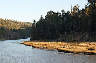
The Noyo River is a river on the north coast of California in Mendocino County. The river's headwaters are in the steep Mendocino Range, but downstream the river flows through gently sloping marine terraces before draining into the Pacific Ocean. The 113 square miles (290 km2) watershed extends east to the small city of Willits and the river's mouth is at Noyo Harbor in Fort Bragg, which uses the river for drinking water; it is neighbored on the south by Hare Creek and the Big River, on the east by the South Fork Eel River, and on the north by Ten Mile River, named for its distance from the Noyo River. The average annual rainfall is between 40 inches (1,000 mm) and 65 inches (1,700 mm).

<span class="mw-page-title-main">Big River (California)</span> River in Mendocino County, California (USA), south of Mendocino Village

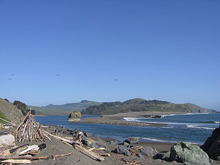
The Big River is a 41.7-mile-long (67.1 km) river in Mendocino County, California, that flows from the northern California Coast Range to the Pacific Ocean at Mendocino, Mendocino County, California. From the mouth, brackish waters extend 8 miles (13 km) upstream, forming the longest undeveloped estuary in the state.

<span class="mw-page-title-main">North Coast (California)</span> Region of California, United States

The North Coast of California is a region in Northern California that lies on the Pacific coast between San Francisco Bay and the Oregon border. It commonly includes Mendocino, Humboldt, and Del Norte counties and sometimes includes Lake and two counties from the San Francisco Bay area, Marin and Sonoma.

<span class="mw-page-title-main">Russian River (California)</span> River in California

The Russian River is a southward-flowing river that drains 1,485 sq mi (3,850 km2) of Sonoma and Mendocino counties in Northern California. With an annual average discharge of approximately 1,600,000 acre feet (2.0 km3), it is the second-largest river flowing through the nine-county Greater San Francisco Bay Area, with a mainstem 115 mi (185 km) long.

<span class="mw-page-title-main">San Francisco and North Pacific Railroad</span> Northern California railroad from Ukiah to Tiburon with ferry to San Francisco (1869-1907)

San Francisco and North Pacific Railroad (SF&NP) provided the first extensive standard gauge rail service to Sonoma County and became the southern end of the regional Northwestern Pacific Railroad. Although first conceived of by Asbury Harpending, who had even obtained many of the right of ways, the SF&NP was bought and subsequently constructed by Peter Donahue, who drove the first spike on August 30, 1869.

<span class="mw-page-title-main">Irmulco, California</span> Archaic placename in California, United States

Irmulco is a former logging town in Mendocino County, California. It was located on the California Western Railroad 12 miles (19 km) north-northeast of Comptche, at an elevation of 436 feet.

<span class="mw-page-title-main">Navarro, California</span> Unincorporated community in California, United States

Navarro is an unincorporated community in Mendocino County in the U.S. state of California. It is located 18 miles (29 km) west of Ukiah, at an elevation of 269 feet (82 m). It may be reached via the east–west California State Route 128, which connects it to the Pacific coast to the west and to the Anderson Valley to the southeast.

<span class="mw-page-title-main">Shake City, California</span> Archaic placename in California, United States

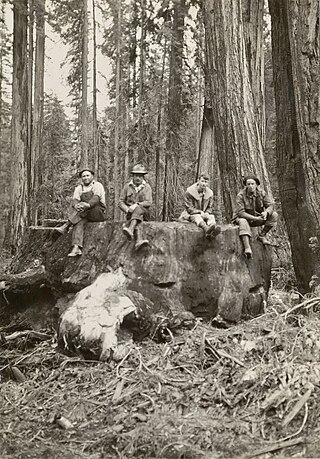
Shake City is an archaic placename in Mendocino County, California. It is located on the California Western Railroad 6.25 miles (10 km) west-northwest of Willits, at an elevation of 528 feet. Circa 1916, a kind of logging operation called a bark camp was located at or near Shake City. For a handful of years in the mid-1930s, the settlement supported a Mendocino County baseball team called the Shake City Loggers. During the Great Depression years there was enough activity at the logging camp that it attracted vagrants: one unemployed man was charged with robbing a cabin near Shake City, and an "unknown tramp" walking from Fort Bragg was killed on the railroad tracks. Famed forestry professor Emanuel Fritz photographed a 17 foot (5.2 m)-diameter redwood stump from a tree logged near Shake City. There was a railroad tie production facility at Shake City in 1937. The railroad trestle at Shake City burned in 1941 but was promptly repaired. By 1960, Shake City was still a name on a map but its history was a mystery to a Petuluma newspaper columnist. In 1967, Union Lumber Company owned timber stands near Shake City.

The Caspar, South Fork & Eastern Railroad provided transportation for the Caspar Lumber Company in Mendocino County, California. The railroad operated the first steam locomotive on the coast of Mendocino County in 1875. Caspar Lumber Company lands became Jackson Demonstration State Forest in 1955, named for Caspar Lumber Company founder, Jacob Green Jackson.

Mendocino Lumber Company operated a sawmill on Big River near the town of Mendocino, California. The sawmill began operation in 1853 as the Redwood Lumber Manufacturing Company, and changed ownership several times before cutting its final logs in 1938. The sawmill site became part of the Big River Unit of Mendocino Headlands State Park where a few features of the mill and its associated forest railway are still visible along the longest undeveloped estuary in northern California.

The Great Redwood Trail is a proposed multi-use rail-to-trail project connecting San Francisco and Humboldt bays in Northern California. Most of the trail will be built on the rail bed of the defunct Northwestern Pacific Railroad along the Eel River Canyon by the Great Redwood Trail Agency. The southern portion will be built by Sonoma–Marin Area Rail Transit (SMART) along their commuter rail line. The trail route is within 5 counties, 14 cities and the ancestral territory of many tribes. Some portions have already constructed by local jurisdictions with more being developed in cooperation with local governments.

References

  1. Hook, James; Franck, Dave; Austin, Steve (1982). An Aid to Collecting Selected Council Shoulder Patches with Valuation.