Regional Municipality of Sudbury

Last updated
Regional Municipality of Sudbury
Dissolved Region
Flag of the Regional Municipality of Sudbury.svg
Logo of the Regional Municipality of Sudbury.svg
Arms of the Regional Municipality of Sudbury.svg
Rmsudbury.png
Municipal boundaries of the former Regional Municipality of Sudbury.
Coordinates: 46°29′24″N81°00′36″W / 46.49000°N 81.01000°W / 46.49000; -81.01000
CountryCanada
Province Ontario
Region Northeastern Ontario
CreatedJanuary 1, 1973
DissolvedDecember 31, 2000
Area
  Total2,607 km2 (1,007 sq mi)
Population
 (1996)
  Total164,049
Time zone UTC−05:00 (EST)
  Summer (DST) UTC−04:00 (DST)
Area code 705
Seat Sudbury
MunicipalitiesSudbury, Capreol, Nickel Centre, Onaping Falls, Rayside-Balfour, Valley East, Walden

The Regional Municipality of Sudbury was a regional municipality that existed in Ontario, Canada, from 1973 to 2000, and was primarily centred on the city of Sudbury. It served as an upper-tier level of municipal government, aggregating municipal services on a region-wide basis like the counties and regional municipalities of Southern Ontario, and was the only upper-tier municipal government ever created in Northern Ontario. The regional municipality was dissolved with the creation of the amalgamated city of Greater Sudbury on January 1, 2001.

Contents

Structure

The regional municipality expanded the boundaries of the city of Sudbury to annex the community of Copper Cliff, the unincorporated geographic township of Broder, and half of the unincorporated geographic township of Dill. The other half of Dill Township — including the community of Wanup — remained unincorporated, although it was subsequently annexed into Greater Sudbury in 2001.

The existing town of Capreol also expanded its boundaries in 1973 to annex the unincorporated communities of Selwood and Milnet. However, despite its status as part of the regional municipality, Statistics Canada did not include the town in Sudbury's Census Metropolitan Area for census purposes.

The towns of Nickel Centre, Onaping Falls, Rayside-Balfour, Valley East and Walden were all newly created by the amalgamation of several smaller towns and townships. Valley East, the largest and fastest-growing of the smaller towns, was granted city status in 1997. All of the municipalities were dissolved into the city of Greater Sudbury in 2001.

Each town and city in the regional municipality had its own mayor and council, and provided many of its own municipal services. The regional municipality had a regional council and chairman of its own, and provided certain services of region-wide interest, such as the regional road network, policing services, and social services.

This was the only regional municipality in Ontario not to originate from a former county government; instead, it was created out of the Sudbury District, which still surrounds the current city. Unlike the counties and regional municipalities of Southern Ontario, the more sparsely populated north is divided into unincorporated districts which do not serve as governing bodies. The Regional Municipality of Sudbury was — and the current city of Greater Sudbury still is — the only census division in Northern Ontario which has the structure and functionality of a Southern Ontario census division.

The regional offices were located at Civic Square, which was also the home of Sudbury's city council. Civic Square was renamed Tom Davies Square in 1997 following the retirement of longtime regional chairman Tom Davies.

History

In the 1976 municipal election, the first municipal elections held after the creation of the regional municipality, voters in three of the suburban towns rejected the new level of government. [1] The strongest opposition was in Onaping Falls, with the vote running against regional government by a margin of 20 to one. [1] Despite the opposition, however, none of the towns was released from the regional government structure.

Amalgamation

On January 1, 2001, all of the seven incorporated municipalities, as well as the regional municipality itself, were amalgamated into the united city of Greater Sudbury. The former municipal names remain in informal use to designate the different areas of the city. The name "Sudbury" itself may be ambiguous, however — depending on the context, it may denote either the old city in isolation, or a shorthand name for the entire amalgamated city.

In addition to the former towns and cities of the Regional Municipality of Sudbury, the unincorporated townships of Dill, Cleland, Fraleck, Parkin, Aylmer, Mackelcan, Rathbun and Scadding were also annexed into the new city. The townships of Cleland and Dill encompass the communities of Wanup and St. Cloud, while the townships of Fraleck, Parkin, Aylmer, Mackelcan, Rathbun and Scadding comprise a wilderness area on the northeast side of Lake Wanapitei which contains only a few recreational properties. However, the annexation of this latter area into the city resulted in Lake Wanapitei supplanting Ramsey Lake, near downtown Sudbury, as the world's largest lake contained entirely within the boundaries of a single city.

Regional Council chairs

Prior to the 1997 municipal elections, the regional chairman was elected to the position from within the regional council — in that year, the position became generally elected by all voters in the regional municipality. Peter Wong, a former mayor of Sudbury, became the region's first elected chair, but died after just seven months in office. Following Wong's death, councillor Doug Craig served as interim chair until he was succeeded by Frank Mazzuca, a former mayor of Capreol, in a 1998 by-election.

  1. Don Collins, 1973–1975
  2. Joe Fabbro, 1975–1977
  3. Doug Frith, 1977–1980
  4. Delki Dozzi, 1980
  5. George Lund, 1980–1981
  6. Tom Davies, 1981–1997
  7. Peter Wong, 1997–1998
  8. Doug Craig, 1998
  9. Frank Mazzuca, 1998–2000

Related Research Articles

<span class="mw-page-title-main">Greater Sudbury</span> City in Ontario, Canada

Sudbury, officially the City of Greater Sudbury, is the largest city in Northern Ontario by population, with a population of 166,004 at the 2021 Canadian Census. By land area, it is the largest in Ontario and the fifth largest in Canada. It is administratively a single-tier municipality and thus is not part of any district, county, or regional municipality. The City of Greater Sudbury is separate from, but entirely surrounded by the Sudbury District. The city is also referred to as "Grand Sudbury" among Francophones.

A regional municipality is a type of Canadian municipal government similar to and at the same municipal government level as a county, although the specific structure and servicing responsibilities may vary from place to place. Regional municipalities were formed in highly populated areas where it was considered more efficient to provide certain services, such as water, emergency services, and waste management over an area encompassing more than one local municipality. For this reason, regions may be involved in providing services to residents and businesses.

<span class="mw-page-title-main">Nickel Centre</span> Community in Ontario, Canada

Nickel Centre was a town in Ontario, Canada, which existed from 1973 to 2000.

<span class="mw-page-title-main">Rayside-Balfour</span> Community in Ontario, Canada

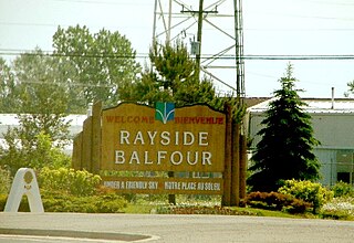
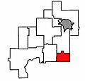
Rayside-Balfour was a town in Ontario, Canada, which existed from 1973 to 2000. It is now part of the city of Greater Sudbury.

<span class="mw-page-title-main">Onaping Falls</span> Community in Ontario, Canada

Onaping Falls was a town in the Canadian province of Ontario, which existed from 1973 to 2000. It was created as part of the Regional Municipality of Sudbury, and took its name from the waterfalls on the Onaping River.

<span class="mw-page-title-main">Capreol</span> Community in Ontario, Canada

Capreol is a community in the Ontario city of Greater Sudbury. Situated on the Vermilion River, Capreol is the city's northernmost populated area.

<span class="mw-page-title-main">Wanup</span> Dispersed rural community in Ontario, Canada

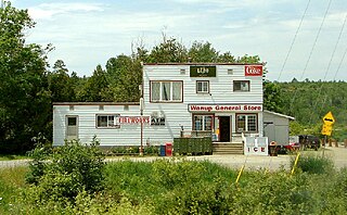
Wanup is a dispersed rural community and unincorporated place in the geographic township of Dill in the southeast of the city of Greater Sudbury, Ontario, Canada. Wanup became part of Greater Sudbury on January 1, 2001, when that city was created by amalgamating the former Regional Municipality of Sudbury, to which the townships of Dill and Cleland were added.

<span class="mw-page-title-main">Greater Sudbury City Council</span>

Greater Sudbury City Council is the governing body of the City of Greater Sudbury, Ontario, Canada.

Peter Wong was a Canadian politician, who served as mayor of Sudbury, Ontario, from 1982 to 1991, and chair of the Regional Municipality of Sudbury from 1997 until his death the following year.

The Greater Sudbury municipal election, 2006 was held in the city of Greater Sudbury, Ontario, Canada on November 13, 2006. All municipal elections in the province of Ontario are held on the same date; see 2006 Ontario municipal elections for elections in other cities.

The Wahnapitae First Nation is an Ojibway First Nation band government in the Canadian province of Ontario, who primarily reside on the 1,036-hectare (2,560-acre) Wahnapitae Indian Reserve No. 11 on the northwestern shore of Lake Wanapitei. The First Nation is a signatory to the Robinson-Huron Treaty of 1850 as the Tahgaiwenene's Band. The reserve had a resident population of 102 in the Canada 2011 Census; the First Nation also has approximately 200 further registered members who currently live off-reserve.

<span class="mw-page-title-main">Ontario Highway 537</span> Ontario provincial highway

Secondary Highway 537, commonly referred to as Highway 537, is a provincially maintained secondary highway in the Canadian province of Ontario. The highway is 16.1 kilometres (10.0 mi) in length, connecting Highway 69 near Wanup with Finni Road. It once continued 3.6 km (2.2 mi) further to intersect Highway 17 in Wahnapitae, but was truncated in 1998; this portion of the route is now designated as Greater Sudbury Municipal Road 537. Highway 537 is now the only secondary highway in the province located within a jurisdiction that also maintains its own county/regional road network.

A merger, consolidation or amalgamation, in a political or administrative sense, is the combination of two or more political or administrative entities, such as municipalities, counties, districts, etc., into a single entity. This term is used when the process occurs within a sovereign entity.

Frank Roger Mazzuca, Sr. was a Canadian politician and businessman in Capreol, Ontario. He served as mayor of the town from 1975 to 1997, and as chair of the Regional Municipality of Sudbury from 1998 to 2000.

<span class="mw-page-title-main">Nickel Belt (provincial electoral district)</span> Provincial electoral district in Ontario, Canada

Nickel Belt is a provincial electoral district located in the Canadian province of Ontario. It elects one member to the Legislative Assembly of Ontario. The district is located in Northern Ontario and includes much of the eastern and southern parts of the District of Sudbury, as well as most of Greater Sudbury outside the city's urban core. Communities include Lively, Onaping, Levack, Dowling, Chelmsford, Naughton, Azilda, Coniston, Wahnapitae, Garson, Val Caron, Val Thérèse, Hanmer and Capreol.

The 1997 Sudbury municipal election was held on November 10, 1997, as voters in Sudbury, Ontario and its outlying communities voted to elected mayors, councillors and school trustees. This was the last municipal election in the region prior to its amalgamation as the new city of Greater Sudbury.

<span class="mw-page-title-main">Ontario Highway 541</span> Former Ontario provincial highway

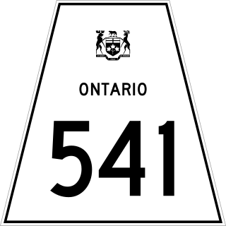
Secondary Highway 541, commonly referred to as Highway 541, was a provincially maintained secondary highway in the Canadian province of Ontario. The highway connected Highway 17 in Sudbury with the community of Skead on the southern shores of Lake Wanapitei, passing through the community of Garson en route. Within the urban region of Sudbury, the highway served to access Sudbury Airport. The designation was applied in 1956, along with many of the secondary highways in Ontario. The province transferred responsibility for the route shortly after the creation of the Regional Municipality of Sudbury in 1973. Highway 541 is now known as Sudbury Municipal Road 86, following Falconbridge Highway and Skead Road.

<span class="mw-page-title-main">Ontario Highway 545</span> Former Ontario provincial highway

Secondary Highway 545, commonly referred to as Highway 545, was a provincially maintained secondary highway in the Canadian province of Ontario. This 33.9-kilometre (21.1 mi) highway connected Highway 541 at Bailey Corners near Garson with the now-abandoned community of Milnet, passing through Hanmer and Capreol. It followed what is now Municipal Road 85, Municipal Road 84, and Milnet Road. The route featured a concurrency with Highway 69 between Hanmer and Capreol.

References

  1. 1 2 "Some upsets, a close vote and a no to regional government". The Globe and Mail , December 7, 1976.