
A geographic information system (GIS) is a conceptualized framework that provides the ability to capture and analyze spatial and geographic data. GIS applications are computer-based tools that allow the user to create interactive queries, store and edit spatial and non-spatial data, analyze spatial information output, and visually share the results of these operations by presenting them as maps.
A geocode is a code that represents a geographic entity. It is a unique identifier of the entity, to distinguish it from others in a finite set of geographic entities. In general the geocode is a human-readable and short identifier.
Ordnance Survey of Northern Ireland (OSNI) was the official mapping agency of Northern Ireland. The agency ceased to exist separately on 1 April 2008 when it became part of Land and Property Services, an executive agency of the Northern Ireland Department of Finance and Personnel, along with the Rate Collection Agency, the Valuation and Lands Agency, and the Land Registry.
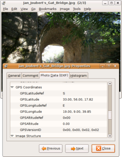
Geotagging, or GeoTagging, is the process of adding geographical identification metadata to various media such as a geotagged photograph or video, websites, SMS messages, QR Codes or RSS feeds and is a form of geospatial metadata. This data usually consists of latitude and longitude coordinates, though they can also include altitude, bearing, distance, accuracy data, and place names, and perhaps a time stamp.
Address geocoding, or simply geocoding, is the process of taking a text-based description of a location, such as an address or the name of a place, and returning geographic coordinates, frequently latitude/longitude pair, to identify a location on the Earth's surface. Reverse geocoding, on the other hand, converts geographic coordinates to a description of a location, usually the name of a place or an addressable location. Geocoding relies on a computer representation of address points, the street / road network, together with postal and administrative boundaries.
Georeferencing means that the internal coordinate system of a map or aerial photo image can be related to a geographic coordinate system. The relevant coordinate transforms are typically stored within the image file, though there are many possible mechanisms for implementing georeferencing. The most visible effect of georeferencing is that display software can show ground coordinates and also measure ground distances and areas.
Oracle Spatial and Graph, formerly Oracle Spatial, is a free option component of the Oracle Database. The spatial features in Oracle Spatial and Graph aid users in managing geographic and location-data in a native type within an Oracle database, potentially supporting a wide range of applications — from automated mapping, facilities management, and geographic information systems (AM/FM/GIS), to wireless location services and location-enabled e-business. The graph features in Oracle Spatial and Graph include Oracle Network Data Model (NDM) graphs used in traditional network applications in major transportation, telcos, utilities and energy organizations and RDF semantic graphs used in social networks and social interactions and in linking disparate data sets to address requirements from the research, health sciences, finance, media and intelligence communities.
The concept of a Geospatial Web may have first been introduced by Dr. Charles Herring in his US DoD paper, An Architecture of Cyberspace: Spatialization of the Internet, 1994, U.S. Army Construction Engineering Research Laboratory.
MapInfo Pro is a desktop geographic information system (GIS) software product produced by Precisely (company) and used for mapping and location analysis. MapInfo Pro allows users to visualize, analyze, edit, interpret, understand and output data to reveal relationships, patterns, and trends. MapInfo Pro allows users to explore spatial data within a dataset, symbolize features, and create maps.
C-squares is a system of spatially unique, location-based identifiers (geocodes) for areas on the surface of the earth, represented as cells from a latitude-longitude based Discrete Global Grid at a hierarchical set of resolution steps. The identifiers incorporate literal values of latitude and longitude in an interleaved notation, together with additional digits that support intermediate grid resolutions of 5, 0.5, 0.05 degrees, etc. The system was initially designed to represent data "footprints" or spatial extents in a more flexible manner than a standard minimum bounding rectangle, and to support "lightweight", text-based spatial querying; it can also provide a set of identifiers for grid cells used for assembly, storage and analysis of spatially organised data. Dataset extents expressed in c-squares notation can be visualised using a web-based utility, the c-squares mapper, an online instance of which is currently provided by CSIRO Oceans and Atmosphere in Australia. C-squares codes and associated published software are free to use and the software is released under version 2 of the GNU General Public License (GPL), a licence of the Free Software Foundation.

CitySurf Globe is a family of Geography 2.0 Geographical Information System software, developed by PiriReis Bilişim Teknolojileri, known as a new model in mapping servers and interaction with the end user. The CitySurf Globe family models raster data, such as high resolution satellite images and aerial images, under high speeds using digital terrain model and vector geographical information systems and accordingly serves these via internet or local nets. It prepares geographical analyses and arranges the geographical data through its interaction with the end user. CitySurf Globe has an OpenGL-based viewer, which connects to the servers for streaming of content, elevation, satellite and/or airphoto imagery, roads, 3D buildings, points of interest, etc. This is similar to Google Earth, Microsoft Virtual Earth, and ArcGIS concepts.
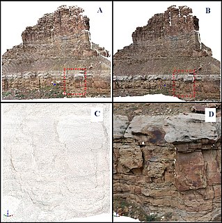
A digital outcrop model (DOM), also called a virtual outcrop model, is a digital 3D representation of the outcrop surface, mostly in a form of textured polygon mesh.
A Crime concentration is a spatial area to which high levels of crime incidents are attributed. A crime concentration can be the result of homogeneous or heterogeneous crime incidents. Hotspots are the result of various crimes occurring in relative proximity to each other within predefined human geopolitical or social boundaries. Crime concentrations are smaller units or set of crime targets within a hotspot. A single or a conjunction of crime concentrations within a study area can make up a crime hotspot.
In geographic information systems, toponym resolution is the relationship process between a toponym, i.e. the mention of a place, and an unambiguous spatial footprint of the same place.

A Discrete Global Grid (DGG) is a mosaic which covers the entire Earth's surface. Mathematically it is a space partitioning: it consists of a set of non-empty regions that form a partition of the Earth's surface. In a usual grid-modeling strategy, to simplify position calculations, each region is represented by a point, abstracting the grid as a set of region-points. Each region or region-point in the grid is called a cell.
What3words is a proprietary geocode system designed to identify any location with a resolution of about 3 metres (9.8 ft). It is owned by What3words Limited, based in London, England. The system encodes geographic coordinates into three permanently fixed dictionary words. For example, the front door of 10 Downing Street in London is identified by ///slurs.this.shark. What3words differs from most location encoding systems in that it displays three words rather than strings of numbers or letters.
Baidu Maps is a desktop and mobile web mapping service application and technology provided by Baidu, offering satellite imagery, street maps, street view and indoor view perspectives, as well as functions such as a route planner for traveling by foot, car, or with public transportation. Android and iOS applications are available.
Due to national law, the use of geographic information in the People's Republic of China is restricted to entities that obtain a special authorization from the administrative department for surveying and mapping under the State Council. Consequences of the restriction include fines for unauthorized surveys, lack of geotagging information on many cameras when the GPS chip detects a location within China, incorrect alignment of street maps with satellite maps in various applications, and the criminalization of crowdsourced mapping efforts such as OpenStreetMap.
Geocoder (Ruby) is a geocoding library for Ruby. Geocoding helps to enhance webpages by presenting location relevant information to the user. When used with Rails, Geocoder adds geocoding functionality such as finding coordinates with street addresses or vice versa in addition to distance calculations for ActiveRecord objects. Since the functionality does not rely on proprietary database functions, finding different geocoded objects in an area works out-of-the-box for databases like MySQL, PostgreSQL and SQLite.