Dalston is an area of East London, in the London Borough of Hackney. It is 4 miles (6.4 km) north-east of Charing Cross. Dalston began as a hamlet on either side of Dalston Lane, and as the area urbanised the term also came to apply to surrounding areas including Kingsland and Shacklewell, all three of which being part of the Ancient Parish of Hackney.

The North London line (NLL) is a railway line which passes through the inner suburbs of west, north-west, north, and east London, England between Richmond in the south-west and Stratford in the east, avoiding central London. Its route is a rough semicircle.

The Metropolitan Borough of Hackney was a Metropolitan borough of the County of London from 1900 to 1965. Its area became part of the London Borough of Hackney.
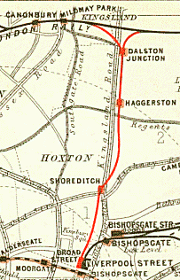
The North London Railway (NLR) company had lines connecting the northern suburbs of London with the East and West India Docks further east. The main east to west route is now part of London Overground's North London Line. Other NLR lines fell into disuse but were later revived as part of the Docklands Light Railway, and London Overground's East London Line. The company was originally called the East & West India Docks & Birmingham Junction Railway (E&WID&BJR) from its start in 1850, until 1853. in 1909 it entered into an agreement with the London and North Western Railway which introduced common management, and the NLR was taken over completely by the LNWR in 1922. The LNWR itself became part of the LMS from the start of 1923. The railways were nationalised in 1948 and most LMS lines, including the North London route, then came under the control of the London Midland Region of British Railways.

Dalston Kingsland railway station is a railway station on the North London Line in London, England. It is in the Dalston area of the London Borough of Hackney, on the western side of Kingsland High Street and opposite Ridley Road Market. The station and all trains serving it are operated by London Overground. It is in Travelcard Zone 2. Kingsland railway station was first opened on the site in 1850, but was replaced by Dalston Junction in 1865. The current station was opened by British Rail in 1983. Ticket barriers are in operation. The station straddles the boundary with the London Borough of Islington, with part of the platforms falling within Islington.
Shoreditch was a railway station on the North London Railway (NLR) in Shoreditch, London, that was in use from 1865 to 1940. It was situated on a viaduct between Haggerston and Broad Street stations. It should not be confused with Shoreditch Underground station (1869–2006) on the London Underground, situated about half a mile further south. It was also not the first main line railway station to possess the Shoreditch name; Bishopsgate (1840–1875) was originally given that name.

Kingsland Road is the name given to an East London stretch of the A10 road within the London Borough of Hackney in England. The A10 was originally a Roman Road better known as Ermine Street or sometimes the Old North Road.

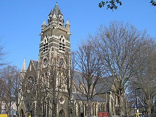
De Beauvoir Town is a neighbourhood in east London and is in the London Borough of Hackney, 2 miles (3.2 km) north of the City of London. The area was a part of the Hackney; the Ancient Parish and subsequent Metropolitan Borough that was incorporated into the larger modern borough. It is sometimes described as a part of Dalston, which is in turn, also a part of the former parish and borough of Hackney.

Dalston Junction is an inter-modal rail and bus transport interchange in Dalston, London. It is located at the crossroads of Dalston Lane, Kingsland Road and Balls Pond Road. The station served by London Overground East London line and is in Zone 2. The station is located in a short section of cut and cover tunnel north of the Kingsland Viaduct.

Shacklewell was a hamlet that developed on Shacklewell Lane in the modern London Borough of Hackney.
Kingsland was a small road-side settlement centred on Kingsland High Street on the Old North Road, around the junction with Dalston Lane. It is no longer discernable as a separate settlement, though the historic street pattern remains. Since the opening of Dalston Junction station in 1865, the area has become known as Dalston, which was originally a separate hamlet further east. Historically part of the county of Middlesex, the area is within the London Borough of Hackney.

Haggerston is a station on the East London line in Haggerston within the London Borough of Hackney, Greater London. The station is located on the Kingsland Viaduct at the junction of Arbutus Street and Frederick Terrace, near Kingsland Road. The main entrance is in Lee Street. The station was built as part of the East London line extension served by National Rail London Overground under the control of the London Rail division of Transport for London, however there is no standard red National Rail "double arrow" logo signage located at the station, instead only the Overground roundel. The next station north is Dalston Junction and the next station south is Hoxton. It is in Travelcard Zone 2.

North Cross Route (NCR) was a planned motorway-standard road which would have formed the northern section of Ringway 1 and would have formed the innermost circuit of the London Ringways network. The six-lane dual carriageway with grade separated junctions to an extended M1 motorway was planned during the late 1960s along with the rest of the Ringway scheme. It was never constructed due to large-scale opposition from many quarters.

Southgate Road is a street in London, England, that runs from Baring Street in the south to the junction with Mildmay Park and Ball's Pond Road in the north. The street forms a part of the B102 road, leading from Newington Green to The City. The west side of Southgate Road is in the London Borough of Islington; and the east side is in the London Borough of Hackney. Southgate Road lies north of the Regent's Canal, west of De Beauvoir Town and east of Essex Road.
Kingsland Viaduct is a railway viaduct about 2 miles (3 km) in length, almost wholly within the present London Borough of Hackney in the north-east part of Inner London. It was built in the 1860s, but was disused from 1986 until it was reopened to carry the London Overground in 2010. The viaduct is owned by Transport for London. Since then it has carried East London Line services between Shoreditch High Street and Dalston.
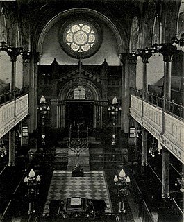
The Dalston Synagogue was a Jewish place of worship in the London Borough of Islington, North London, from about 1885 to 1970. Jews fleeing the pogroms of the Russian Empire, and those beginning to leave the East End of London and move northwards towards Stoke Newington and Stamford Hill established a congregation in the neighbourhood by 1876. The Victorian Gothic building was erected in Poets Road in 1885, a street just outside the boundaries of Dalston, and became one of the leading members of the United Synagogues.
The City Branch was a short spur of the North London Line allowing direct access from the east-west main route of the North London Railway to the terminus at Broad Street in the City of London.

The Metropolitan Free Hospital was a London hospital, founded in 1836 and based for most of its existence in Kingsland Road, Hackney. It became part of the NHS in 1948, and closed in 1977, with its residual functions transferring to Barts Hospital.

Hackney is a district in East London, England, forming around two-thirds of the area of the modern London Borough of Hackney, to which it gives its name. It is 4 miles (6.4 km) northeast of Charing Cross and includes part of the Queen Elizabeth Olympic Park. Historically it was within the county of Middlesex.
