
Perthshire, officially the County of Perth, is a historic county and registration county in central Scotland. Geographically it extends from Strathmore in the east, to the Pass of Drumochter in the north, Rannoch Moor and Ben Lui in the west, and Aberfoyle in the south; it borders the counties of Inverness-shire and Aberdeenshire to the north, Angus to the east, Fife, Kinross-shire, Clackmannanshire, Stirlingshire and Dunbartonshire to the south and Argyllshire to the west. It was a local government county from 1890 to 1930.

The River Dee, in south-west Scotland, flows from its source in Loch Dee amongst the Galloway Hills, firstly to Clatteringshaws Loch, then into Loch Ken, where it joins the Water of Ken. From there, the Dee flows 15 miles (24 km) southwards to Kirkcudbright, and into Kirkcudbright Bay to reach the Solway Firth. The distance is just over 38 miles (61 km) in total. Together with its tributaries, the Dee's total catchment area is over 400 square miles (1,000 km2).
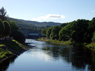
The River Tummel is a river in Perth and Kinross, Scotland. Water from the Tummel is used in the Tummel hydro-electric power scheme, operated by SSE.

Loch Tummel is a long, narrow loch, seven kilometres northwest of Pitlochry in the council area of Perth and Kinross, Scotland. It is fed and drained by the River Tummel, which flows into the River Tay about 13 km (8 mi) south-east of the Clunie Dam at the loch's eastern end.

Glen Tilt is a glen in the extreme north of Perthshire, Scotland. Beginning at the confines of Aberdeenshire, it follows a South-westerly direction excepting for the last 4 miles, when it runs due south to Blair Atholl. It is watered throughout by the Tilt, which enters the Garry after a course of 14 miles, and receives on its right the Tarf, which forms some beautiful falls just above the confluence, and on the left the Fender, which has some fine falls also. The attempt of George Murray, 6th Duke of Atholl to close the glen to the public was successfully contested by the Scottish Rights of Way Society in 1847. The massive mountain of Beinn a' Ghlò and its three Munros Càrn nan Gabhar, Bràigh Coire Chruinn-bhalgain and Càrn Liath (975) dominate the glen's eastern lower half.

Kinloch Rannoch is a village in Perth and Kinross, Scotland, at the eastern end of Loch Rannoch, 18 miles (29 km) west of Pitlochry, on the banks of the River Tummel. The village is a tourist and outdoor pursuits centre. It has a small population and is fairly remote.

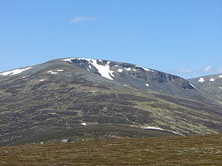
Càrn a' Chlamain is a Scottish mountain situated roughly 12 kilometres north of Blair Atholl in the Forest of Atholl. It is the highest point of an undulating plateau lying northeast of Glen Tilt. The River Tarf, a tributary of the Tilt, rises on the northwestern slopes before curving round the northern side of the plateau, whilst a further Tilt tributary marks the plateau's western boundary.
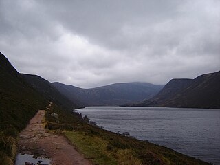
Loch Muick is an upland, freshwater loch lying approximately 5 mi (8.0 km) south of Braemar, Scotland at the head of Glen Muick and within the boundary of the Balmoral estate.
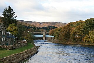
The Tummel hydro-electric power scheme is an interconnected network of dams, power stations, aqueducts and electric power transmission in the Grampian Mountains of Scotland. Roughly bounded by Dalwhinnie in the north, Rannoch Moor in the west and Pitlochry in the east it comprises a water catchment area of around 1,800 square kilometres (690 sq mi) and primary water storage at Loch Ericht, Loch Errochty, Loch Rannoch and Loch Tummel, in Perth and Kinross. Water, depending on where it originates and the path it takes, may pass through as many as five of the schemes nine power stations as it progresses from north-west to south-east. The scheme was constructed in the 1940s and 50s incorporating some earlier sites. It is currently managed by SSE plc.
The North Esk is a river in Angus and Aberdeenshire, Scotland. It is formed by the meeting of the Water of Mark and the Water of Lee, and enters the North Sea four miles north of Montrose. It forms the boundary between Angus and Aberdeenshire at certain stages in its course. It was also noted in the 19th century as a good point for fishing.
Sgairneach Mhòr is a Scottish mountain which lies in a group of seven Munros near the summit of the Pass of Drumochter and are known as the Drumochter mountains or informerly as the “A9 Munros”. The mountain is situated 13 km SSW of Dalwhinnie and four km east of the large Loch Ericht.

Loch Errochty is a man made freshwater loch situated within the Perth and Kinross council area at the edge of the Scottish Highlands near the Highland Boundary Fault where the topography changes to lowland.

The Sow of Atholl is a Scottish hill which is situated 27 kilometres west-northwest of the town of Blair Atholl in Perth and Kinross council area. It stands on the western side of the Pass of Drumochter in a group of hills which lie around Coire Dhomhain.

Beinn a' Chuallaich is a Scottish hill, four kilometres northeast of the village of Kinloch Rannoch in the Perth and Kinross council area. It is part of the high ground between Strath Tummel and Glen Errochty.

The River Truim is a right bank tributary of the River Spey in the Scottish Highlands. Its headwaters meet to the north of the Pass of Drumochter and flow northwards as the Truim past the dam at the northern end of Loch Ericht and through the village of Dalwhinnie, highest village in the Scottish Highlands. The distillery at Dalwhinnie producing Dalwhinnie Single Malt is also the highest in Scotland. The waters of its most significant tributary, the Allt Cuaich, are diverted in part along an aqueduct to Loch Ericht. The river continues north-northeastwards down Glen Truim, over the Falls of Truim and on to meet the Spey 2.5 miles (4 km) southwest of Newtonmore. It is closely followed for almost its entire length by both the A9 road and the mainline railway from Perth to Inverness.

The River Tromie is a right bank tributary of the River Spey in northeast Scotland. It emerges from the northern end of Loch an t-Seilich within the Gaick Forest and flows northwards, then northwestwards down through Glen Tromie to Bhran Cottage where it turns to the north-northeast. It is bridged by the B970 road at Tromie Bridge near Drumguish and flows a further 1.25 miles (2 km) northwest to meet the Spey near Lynchat.
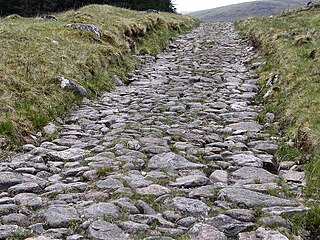
A network of military roads, sometimes called General Wade's Military Roads, was constructed in the Scottish Highlands during the middle part of the 18th century as part of an attempt by the British Government to bring order to a part of the country which had risen up in the Jacobite rebellion of 1715.
Struan is a small village in Perthshire in Scotland. The name derives from the Gaelic for 'Little Stream'. It is 8 km west of Blair Atholl.
The River Tilt is a tributary of the River Garry in Perth and Kinross, Scotland. It is sourced from the confluence of Tarf Water and the Allt Garbh Buidhe, from which point it flows in a southwesterly direction down the fault-aligned Glen Tilt. In the vicinity of Marble Lodge, it turns gradually to a more southerly course and, at Blair Atholl, enters the left bank of the Garry after being bisected by two islands. The river's elevation drops 270 metres (890 ft) between source and mouth.
