Rock Island, Oklahoma

Last updated

Rock Island, Oklahoma
OKMap-doton-RockIsland.PNG
Location of Rock Island, Oklahoma
Coordinates: 35°10′59″N94°28′52″W / 35.18306°N 94.48111°W / 35.18306; -94.48111
Country United States
State Oklahoma
County Le Flore
Area
[1]
  Total12.23 sq mi (31.68 km2)
  Land12.17 sq mi (31.53 km2)
  Water0.06 sq mi (0.16 km2)
Elevation
[2]
502 ft (153 m)
Population
 (2020)
  Total717
  Density58.90/sq mi (22.74/km2)
Time zone UTC-6 (Central (CST))
  Summer (DST) UTC-5 (CDT)
FIPS code 40-63600 [3]
GNIS feature ID2412560 [2]

Rock Island is a town in Le Flore County, Oklahoma, United States. It is part of the Fort Smith, Arkansas-Oklahoma Metropolitan Statistical Area. The population was 646 at the 2010 census, a decline of 8.9 percent from the figure of 709 recorded in 2000. [4]

Contents

History

The Fort Smith and Southern Railway built a north–south line through what is now Le Flore County in 1886; the line was sold the next year to the St. Louis and San Francisco Railroad ("the Frisco"). In 1903–04 the Midland Valley Railroad laid an east-west line. The settlement originally known as Maney Junction developed at the crossing of these railroads. [5]

A post office was established as Rock Island, Indian Territory on February 1, 1905. It was presumably named for Rock Island, Illinois. [6] At the time of its founding, the community was located in Skullyville County, part of the Moshulatubbee District of the Choctaw Nation. [7]

Rock Island started the process of incorporation in 1989, but the County Commissioners did not approve the incorporation until 2004. [8]

Geography

Rock Island is 13 miles (21 km) northeast of Poteau. [8]

The town sits on Oklahoma State Highway 112 at the western terminus of Oklahoma State Highway 120. [9]

According to the United States Census Bureau, the town has a total area of 12.2 square miles (32 km2), of which 12.1 square miles (31 km2) is land and 0.1 square miles (0.26 km2) (0.66%) is water.

Economy

Rock Island's economy has depended on agriculture since its founding. Many residents now commute to work in nearby towns such as Poteau and Fort Smith. [8]

Railroad tunnel

Jenson Tunnel is located just northeast of Rock Island and is the only known railroad tunnel in Oklahoma. Now used by the Kansas City Southern, it was built by Frisco Railway in 1885 and is approximately 1,180 feet long.[ citation needed ]

Demographics

Historical population
CensusPop.Note
1990 478
2000 70948.3%
2010 646−8.9%
2020 71711.0%
U.S. Decennial Census [10]

As of the census [3] of 2000, there were 709 people, 264 households, and 213 families residing in the town. The population density was 58.6 inhabitants per square mile (22.6/km2). There were 279 housing units at an average density of 23.1 per square mile (8.9/km2). The racial makeup of the town was 87.73% White, 5.64% Native American, 0.14% Asian, 0.56% from other races, and 5.92% from two or more races. Hispanic or Latino of any race were 1.97% of the population.

There were 264 households, out of which 40.2% had children under the age of 18 living with them, 67.0% were married couples living together, 7.6% had a female householder with no husband present, and 19.3% were non-families. 16.3% of all households were made up of individuals, and 7.2% had someone living alone who was 65 years of age or older. The average household size was 2.69 and the average family size was 3.02.

In the town, the population was spread out, with 29.1% under the age of 18, 8.6% from 18 to 24, 28.2% from 25 to 44, 25.4% from 45 to 64, and 8.7% who were 65 years of age or older. The median age was 36 years. For every 100 females, there were 115.5 males. For every 100 females age 18 and over, there were 107.0 males.

The median income for a household in the town was $30,625, and the median income for a family was $34,545. Males had a median income of $26,442 versus $18,625 for females. The per capita income for the town was $14,115. About 8.9% of families and 11.5% of the population were below the poverty line, including 11.6% of those under age 18 and 11.4% of those age 65 or over.

Related Research Articles

<span class="mw-page-title-main">LeFlore County, Oklahoma</span> County in Oklahoma, United States

LeFlore County is a county along the eastern border of the U.S state of Oklahoma. As of the 2020 census, the population was 48,129. Its county seat is Poteau. The county is part of the Fort Smith metropolitan area and the name honors a Choctaw family named LeFlore. The United States District Court for the Eastern District of Oklahoma is the federal district court with jurisdiction in LeFlore County.

<span class="mw-page-title-main">Johnston County, Oklahoma</span> County in Oklahoma, United States

Johnston County is a county located in the U.S. state of Oklahoma. As of the 2020 census, the population was 10,272. Its county seat is Tishomingo. It was established at statehood on November 16, 1907, and named for Douglas H. Johnston, a governor of the Chickasaw Nation.

<span class="mw-page-title-main">Van Buren, Arkansas</span> City in Arkansas, United States

Van Buren is the second-largest city in the Fort Smith, Arkansas–Oklahoma Metropolitan Statistical Area and the county seat of Crawford County, Arkansas, United States. The city is located directly northeast of Fort Smith at the Interstate 40 – Interstate 540 junction. The city was incorporated in 1845 and as of the 2020 census had a population of 23,218, ranking it as the state's 21st largest city.

<span class="mw-page-title-main">Fort Cobb, Oklahoma</span> Town in Oklahoma, United States

Fort Cobb is a town in Caddo County, Oklahoma, United States. The population was 518 at the 2020 census.

<span class="mw-page-title-main">Breckinridge, Oklahoma</span> Town in Oklahoma, United States

Breckinridge, sometimes spelled Breckenridge, is a town in Garfield County, Oklahoma, United States. The population was 199 as of the 2020 Census.

<span class="mw-page-title-main">Fairmont, Oklahoma</span> Town in Oklahoma, United States

Fairmont is a town in Garfield County, Oklahoma, United States. The population was 134 at the 2010 census, a decrease from 147 at the 2000 census.

<span class="mw-page-title-main">Mountain View, Oklahoma</span> Town in Oklahoma, United States

Mountain View is a town in Kiowa County, Oklahoma, United States. Its population was 740 as of the 2020 United States census. It is situated about 23 miles east of the county seat of Hobart, at the intersection of Oklahoma State Highway 9 and Oklahoma State Highway 115.

<span class="mw-page-title-main">Arkoma, Oklahoma</span> Town in Oklahoma, United States

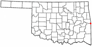
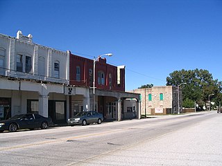
Arkoma is a town in LeFlore County, Oklahoma, United States. It is part of the Fort Smith, Arkansas-Oklahoma Metropolitan Statistical Area. The population was 1,989 at the 2010 census, a decline from 2,180 in 2000. The name of the town is a portmanteau of Arkansas and Oklahoma. Throughout its history, Arkoma has served as a "bedroom community" because many residents commuted to work in Fort Smith.

<span class="mw-page-title-main">Cameron, Oklahoma</span> Town in Oklahoma, United States

Cameron is a town in Le Flore County, Oklahoma, United States. It is part of the Fort Smith, Arkansas-Oklahoma Metropolitan Statistical Area. The population was 302 at the 2010 census, a decline of 3.2 percent from the figure of 312 recorded in 2000.

<span class="mw-page-title-main">Heavener, Oklahoma</span> City in Oklahoma, United States

Heavener is a town in Le Flore County, Oklahoma, United States. The population was 3,414 at the 2010 census, an increase of 6.7 percent from 3,201 at the 2000 census. Heavener is notable for the Heavener Runestone just outside the city limits.

<span class="mw-page-title-main">Howe, Oklahoma</span> Town in Oklahoma, United States

Howe is a town in Le Flore County, Oklahoma, United States. It is part of the Fort Smith, Arkansas-Oklahoma Metropolitan Statistical Area. The population was 802 at the 2010 census, a gain of 15.1 percent over the figure of 697 recorded in 2000. The town was once noted for producing coal and coke, but today is chiefly supported by agriculture.

<span class="mw-page-title-main">LeFlore, Oklahoma</span> Town in Oklahoma, United States

LeFlore is a town in LeFlore County, Oklahoma, United States. It is part of the Fort Smith, Arkansas-Oklahoma Metropolitan Statistical Area. The population was 198 at the 2010 census, an increase of 13.1 percent over the figure of 168 in 2000. Although the legal town name is spelled in the two-word form, the official federal name for the place and the postal name used is Leflore.

<span class="mw-page-title-main">Panama, Oklahoma</span> Town in Oklahoma, United States

Panama is a town in Le Flore County, Oklahoma, United States. It is part of the Fort Smith, Arkansas-Oklahoma Metropolitan Statistical Area. The population was 1,413 at the 2010 census.

<span class="mw-page-title-main">Pocola, Oklahoma</span> Town in Oklahoma, United States

Pocola is a town in Le Flore County, Oklahoma, United States. It is part of the Fort Smith, Arkansas-Oklahoma metropolitan area. The population was 4,056 in 2010, a gain of 1.6 percent over the figure of 3,994 recorded in 2000. Pocola is a Choctaw word meaning "ten", the approximate distance in miles from Fort Smith, Arkansas.

<span class="mw-page-title-main">Poteau, Oklahoma</span> City in Oklahoma, United States

Poteau is a city in, and county seat of, Le Flore County, Oklahoma, United States. The population was 8,520 as of the 2010 census.

<span class="mw-page-title-main">Shady Point, Oklahoma</span> Town in Oklahoma, United States

Shady Point, sometimes referred to as Shadypoint, is a town in Le Flore County, Oklahoma, United States. It is part of the Fort Smith, Arkansas-Oklahoma Metropolitan Statistical Area. The population was 1,026 at the 2010 census, a 21.0 percent increase over the figure of 848 recorded in 2000.

<span class="mw-page-title-main">Talihina, Oklahoma</span> Town in Oklahoma, United States

Talihina is a town in LeFlore County, Oklahoma, United States, its name originating from two Choctaw words, tully and hena, meaning "iron road," a reference to the railroad around which the town was built. It is part of the Fort Smith, Arkansas–Oklahoma Metropolitan Statistical Area. The population was 925 at the time of the 2020 Census.

<span class="mw-page-title-main">Wister, Oklahoma</span> Town in Oklahoma, United States

Wister is a town in Le Flore County, Oklahoma, United States. It is part of the Fort Smith metropolitan area. The population was 1,102 at the 2010 census. Wister is named for Gutman G. Wister, an official with the Choctaw, Oklahoma and Gulf Railroad.

<span class="mw-page-title-main">Afton, Oklahoma</span> Town in Oklahoma, United States

Afton is a town in northeast Oklahoma in Ottawa County, Oklahoma, United States. The population was 734 at the time of the 2020 United States census.

<span class="mw-page-title-main">Fanshawe, Oklahoma</span> Town in Oklahoma, United States

Fanshawe is a town in Latimer and Le Flore counties in the U.S. state of Oklahoma. As of the 2020 Census, the town had a total population of 317. The Le Flore County portion of Fanshawe is part of the Fort Smith, Arkansas-Oklahoma Metropolitan Statistical Area.

References

  1. "ArcGIS REST Services Directory". United States Census Bureau. Retrieved September 20, 2022.
  2. 1 2 U.S. Geological Survey Geographic Names Information System: Rock Island, Oklahoma
  3. 1 2 "U.S. Census website". United States Census Bureau . Retrieved January 31, 2008.
  4. CensusViewer:Rock Island, Oklahoma Population.
  5. "Rock Island". Charlene Williams Dunn, Oklahoma Historical Society. Retrieved August 19, 2020.
  6. Shirk, George H. Oklahoma Place Names (Norman: University of Oklahoma, 1965), p. 181.
  7. Morris, John W. Historical Atlas of Oklahoma (Norman: University of Oklahoma, 1986), plate 38.
  8. 1 2 3 Charlene Williams Dunn, "Rock Island," Encyclopedia of Oklahoma History and Culture. Accessed March 22, 2015.
  9. "Rock Island, OK". Google Maps. Retrieved August 19, 2020.
  10. "Census of Population and Housing". Census.gov. Retrieved June 4, 2015.