Roseboro, North Carolina

Last updated

Roseboro, North Carolina
Downtown Roseboro 2.jpg
Downtown Roseboro
Motto(s): 
Take Root and Bloom
USA North Carolina location map.svg
Red pog.svg
Roseboro, North Carolina
Location within the state of North Carolina
Coordinates: 34°57′18″N78°30′49″W / 34.95500°N 78.51361°W / 34.95500; -78.51361
Country United States
State North Carolina
County Sampson
Area
[1]
  Total1.45 sq mi (3.75 km2)
  Land1.45 sq mi (3.75 km2)
  Water0.00 sq mi (0.01 km2)
Elevation
[2]
125 ft (38 m)
Population
 (2020)
  Total1,163
  Density803.73/sq mi (310.42/km2)
Time zone UTC-5 (Eastern (EST))
  Summer (DST) UTC-4 (EDT)
ZIP code
28382
Area codes 910, 472
FIPS code 37-57800 [3]
GNIS feature ID2407245 [2]

Roseboro is a town in Sampson County, North Carolina, United States. The population was 1,163 at the 2020 census.

Contents

History

Roseboro was founded when the Cape Fear and Yadkin Valley Railroad built a line from Fayetteville to Wilmington, and it joined Stedman, Autryville, Garland, Kerr Station and several other communities that sprang to life when depots were built and commerce came into being. The railroad was built in 1889-1890.

There are two stories of how Roseboro got its name, but research has proven it to be named after John M. Rose, secretary of the Cape Fear and Yadkin Valley Railroad. The town has grown since 1889. Roseboro was incorporated in 1891 by the North Carolina General Assembly and the first mayor was Almond Butler, an ancestor of Miss Ossie Butler, long time town clerk for Roseboro. According to a copy of the town charter on file in the town office, E.R. Johnson was the first town marshal. All but one of the first commissioner's last names is still prominent in the town. Roseboro did not do a lot of growing at first. First accounts of the town are of a few houses and several general stores.[ citation needed ]

Roseboro's oldest building was constructed around 1897 by W.J. Fisher. In 1908, Dr. Paul M. Crumpler practiced medicine in front of the building while Whit Tart operated a drug store in the rear, thus the beginning of Tart & West Drug Store. In 1930, Paul and Sammy Butler opened a barber shop at the site. In the 1950s, Willie Butler moved in and began a mortgage and finance company. In the late 1950s, it was leased to Vander Simmons who used it for an accounting office. In 1961, Mr. Lennon H. Fisher, grandson of W.J. Fisher, took occupancy of this building and formed Fisher Insurance Agency. It remained at that location until 1978. In 1989, Jim Buchanan moved into this building and opened a photography business. In 1990, he changed the name to Jim B’S E-Z Rental. Currently, Summerlyn Naylor, great-great-granddaughter of W.J. Fisher, operates a business in the building.[ citation needed ]

The Dan E. Caison Sr. House, Troy Herring House, and Howell–Butler House were listed on the National Register of Historic Places in 1986. [4]

Geography

According to the United States Census Bureau, the town has a total area of 1.2 square miles (3.1 km2), all land.

Demographics

Historical population
CensusPop.Note
1900 63
1910 183190.5%
1920 749309.3%
1930 7682.5%
1940 93922.3%
1950 1,24132.2%
1960 1,3549.1%
1970 1,235−8.8%
1980 1,227−0.6%
1990 1,44117.4%
2000 1,267−12.1%
2010 1,191−6.0%
2020 1,163−2.4%
U.S. Decennial Census [5]

2020 census

Roseboro racial composition [6]
RaceNumberPercentage
White (non-Hispanic)44838.52%
Black or African American (non-Hispanic)54747.03%
Native American 30.26%
Asian 100.86%
Other/Mixed 615.25%
Hispanic or Latino 948.08%

As of the 2020 United States census, there were 1,163 people, 549 households, and 275 families residing in the town.

2000 census

As of the census [3] of 2000, there were 1,267 people, 509 households, and 365 families residing in the town. The population density was 1,084.8 inhabitants per square mile (418.8/km2). There were 567 housing units at an average density of 485.5 per square mile (187.5/km2). The racial makeup of the town was 47.43% White, 48.93% African American, 1.26% Native American, 0.32% Asian, 1.58% from other races, and 0.47% from two or more races. Hispanic or Latino of any race were 2.60% of the population.

There were 509 households, out of which 37.5% had children under the age of 18 living with them, 40.7% were married couples living together, 25.9% had a female householder with no husband present, and 28.1% were non-families. 25.0% of all households were made up of individuals, and 13.2% had someone living alone who was 65 years of age or older. The average household size was 2.49 and the average family size was 2.92.

In the town, the population was spread out, with 30.0% under the age of 18, 8.2% from 18 to 24, 28.0% from 25 to 44, 17.5% from 45 to 64, and 16.3% who were 65 years of age or older. The median age was 34 years. For every 100 females, there were 79.7 males. For every 100 females age 18 and over, there were 70.9 males.

The median income for a household in the town was $23,478, and the median income for a family was $26,154. Males had a median income of $29,306 versus $17,216 for females. The per capita income for the town was $15,704. About 23.6% of families and 24.9% of the population were below the poverty line, including 35.1% of those under age 18 and 18.7% of those age 65 or over.

Notable people

Related Research Articles

<span class="mw-page-title-main">Surry County, North Carolina</span> County in North Carolina, United States

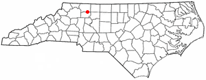
Surry County is a county located in the U.S. state of North Carolina. As of the 2020 census, the population was 71,359. Its county seat is Dobson, and its largest community is Mount Airy.

<span class="mw-page-title-main">Sampson County, North Carolina</span> County in North Carolina, United States

Sampson County is a county located in the U.S. state of North Carolina. As of the 2020 census, the population was 59,036. Its county seat is Clinton.

<span class="mw-page-title-main">Goldston, North Carolina</span> Town in North Carolina, United States

Goldston is a town in Chatham County, North Carolina, United States, south of Pittsboro. The population was 268 at the 2010 census.

Bermuda Run is a town in Davie County, North Carolina, United States. As of the 2020 census, the population of the town was 3,120. It was incorporated in 1999 as a fully gated residential community near country clubs and golf courses like the Bermuda Run Country Club, Oak Valley Golf Club, and Tanglewood Park. In 2000, the town annexed into neighboring Hillsdale, picking up a commercial district. The town rests on the western bank of the Yadkin River along U.S. Route 158 and North Carolina Highway 801. Interstate 40 provides express access to Winston-Salem, the town's nearest urban center. In 2012, Kinderton Village was voluntarily annexed by the town of Bermuda Run. Bermuda Run is considered by the locals to be a mid-high class community and the second-most influential, behind nearby Oak Valley.

<span class="mw-page-title-main">Rural Hall, North Carolina</span> Town in North Carolina, United States

Rural Hall is a town in Forsyth County, North Carolina, United States. It is a part of the Piedmont Triad. The population was 3,360 at the 2020 census. The town has one public park: Covington Memorial Park.

<span class="mw-page-title-main">Micro, North Carolina</span> Town in North Carolina, United States

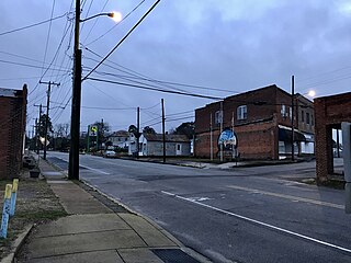
Micro is a town in Johnston County, North Carolina, United States. The population was 458 as of the 2020 census, up from 441 in the 2010 census.

<span class="mw-page-title-main">Carolina Beach, North Carolina</span> Town in North Carolina, United States

Carolina Beach is a beach town in New Hanover County, North Carolina, United States, situated about 12 miles (19 km) south of Wilmington International Airport in southeastern coastal North Carolina. As of the 2020 census, the city population was 6,564. It is part of the Wilmington metropolitan area. The community of Wilmington Beach was annexed by the town in 2000.

<span class="mw-page-title-main">Seaboard, North Carolina</span> Town in North Carolina, United States

Seaboard is a township in Northampton County, North Carolina, United States, created as a company town by the Seaboard and Roanoke Railroad, approximately 10 miles northeast of Weldon in the mid-1840s as a place for railroad employees to live.

<span class="mw-page-title-main">Autryville, North Carolina</span> Town in North Carolina, United States

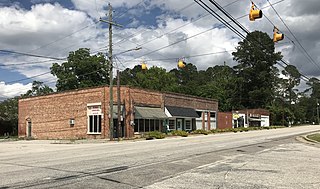
Autryville is a town in Sampson County, North Carolina, United States. The population was 167 at the 2020 census. The town is located in western Sampson County along the banks of the South River, adjacent to Cumberland County. Autryville is governed by a mayor and a five-member town commission. The town is about 15 miles east-southeast of Fayetteville along NC 24.

<span class="mw-page-title-main">Clinton, North Carolina</span> City in North Carolina, United States

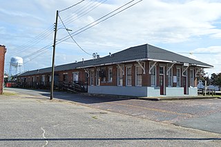
Clinton is a city in and the county seat of Sampson County, North Carolina, United States. As of the 2020 census, the population was 8,383. Clinton is named for Richard Clinton, a Brigadier General of the North Carolina militia in the American Revolution.

<span class="mw-page-title-main">Albemarle, North Carolina</span> City in North Carolina, United States

Albemarle is a city in and the county seat of Stanly County, North Carolina, United States. The population was 16,432 in the 2020 census.

<span class="mw-page-title-main">Norwood, North Carolina</span> Town in North Carolina, United States

Norwood is a town in Stanly County, North Carolina, United States. The population was 2,379 at the 2010 census.

<span class="mw-page-title-main">Dobson, North Carolina</span> Town in North Carolina, United States

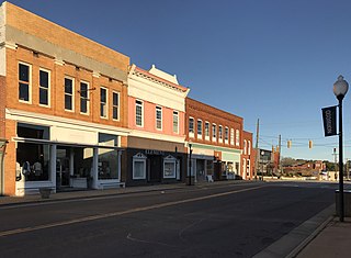
Dobson is a town in Dobson Township, Surry County, North Carolina, United States. As of the 2020 census, the town population was 1,396. It is the county seat of Surry County. Dobson is the home of the Shelton Vineyards, the largest winery in North Carolina. It is also home to a significant Latino population due to the large number of farms in the area. The main crops in the area are corn, tobacco and soy beans.

<span class="mw-page-title-main">Pilot Mountain, North Carolina</span> Town in North Carolina, United States

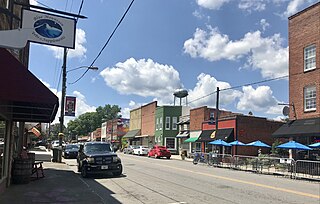
Pilot Mountain is a town in Surry County, North Carolina, United States. The population was 1,443 at the 2020 census. It is named for the nearby landmark of Pilot Mountain, a distinctive geological formation.

<span class="mw-page-title-main">Ronda, North Carolina</span> Town in North Carolina, United States

Ronda is a town in Wilkes County, North Carolina, United States. The population was 417 at the 2010 census, and 413 at the 2020 census. Ronda was named after a nearby estate called "Roundabout", which was the residence of Benjamin Cleveland, a locally prominent planter and a colonel in the North Carolina militia during the Revolutionary War. The town is home to East Wilkes High School, one of Wilkes County's five public high schools.

<span class="mw-page-title-main">Boonville, North Carolina</span> Town in North Carolina, United States

Boonville is a town in Yadkin County, North Carolina, United States. The population was 1,222 at the 2010 census.

<span class="mw-page-title-main">East Bend, North Carolina</span> Town in North Carolina, United States

East Bend is a town in northeastern Yadkin County, North Carolina, United States. The population is 634 at the 2020 census. It is a Piedmont Triad community.

<span class="mw-page-title-main">Jonesville, North Carolina</span> Town in North Carolina, United States

Jonesville, originally called Allen's Settlement, is the oldest town in Yadkin County, North Carolina, United States. The population was 2,285 at the 2010 census. The town grew by nearly 800 residents in 2001 when it merged with neighboring Arlington. Recognized as the Heart of the Yadkin Valley, Jonesville is a gateway to the Blue Ridge Mountains, the Yadkin Valley Heritage/Cultural Corridor and to local wineries in the Swan Creek AVA and the larger Yadkin Valley AVA, as well as offering access to the Yadkin river.

<span class="mw-page-title-main">Yadkinville, North Carolina</span> Town in North Carolina, United States

Yadkinville is a town in Yadkin County, North Carolina, United States. The population was 2,995 at the 2020 census. Located in the Piedmont Triad, it is the county seat and most populous city of Yadkin County.

Harrells is a town in Duplin and Sampson counties, North Carolina, United States. The population was 160 at the 2020 census. At the previous census in 2010, the population was 202.

References

  1. "ArcGIS REST Services Directory". United States Census Bureau. Retrieved September 20, 2022.
  2. 1 2 U.S. Geological Survey Geographic Names Information System: Roseboro, North Carolina
  3. 1 2 "U.S. Census website". United States Census Bureau . Retrieved January 31, 2008.
  4. "National Register Information System". National Register of Historic Places . National Park Service. July 9, 2010.
  5. "Census of Population and Housing". Census.gov. Retrieved June 4, 2015.
  6. "Explore Census Data". data.census.gov. Retrieved December 24, 2021.
  7. Medal of Honor Winner Rufus Herring of Sampson County. ncdcr.gov. Retrieved October 19, 2020.
  8. Rep Bill Johnson, R-Ohio. Retrieved October 19, 2020.
  9. Chasity Melvin 2017. North Carolina Sports Hall of Fame. Retrieved October 19, 2020.
  10. George Williams Stats. Pro-Football-Reference. Retrieved October 19, 2020.