
The Challenger Deep is the deepest known point of the seabed of Earth. Its depth is measured at 10,902–10,929 m (35,768–35,856 ft) by direct measurement from deep-diving submersibles, remotely operated underwater vehicles and benthic landers, and (sometimes) slightly more by sonar bathymetry.
A Nansen bottle is a device for obtaining samples of water at a specific depth. It was designed in 1894 by Fridtjof Nansen and further developed by Shale Niskin in 1966.

The bathythermograph, or BT, also known as the Mechanical Bathythermograph, or MBT; is a device that holds a temperature sensor and a transducer to detect changes in water temperature versus depth down to a depth of approximately 285 meters. Lowered by a small winch on the ship into the water, the BT records pressure and temperature changes on a coated glass slide as it is dropped nearly freely through the water. While the instrument is being dropped, the wire is paid out until it reaches a predetermined depth, then a brake is applied and the BT is drawn back to the surface. Because the pressure is a function of depth, temperature measurements can be correlated with the depth at which they are recorded.
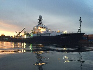
R/V Roger Revelle is a Thomas G. Thompson-class oceanographic research ship operated by Scripps Institution of Oceanography under charter agreement with Office of Naval Research as part of the University-National Oceanographic Laboratory System (UNOLS) fleet. The ship is named after Roger Randall Dougan Revelle, who was essential to the incorporation of Scripps into the University of California San Diego.
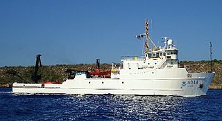
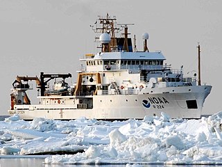
The NOAA Ship Nancy Foster is a National Oceanic and Atmospheric Administration research vessel. The ship is named for Dr. Nancy Foster, who was the director of the National Marine Fisheries Service’s Office of Protected Resources from 1986 until 1993, and the director of the National Ocean Service from 1997 until her death in 2000.

The Institute of Marine Sciences (IMS) is a Turkish facility that focuses on marine science-related education and research. IMS was founded in 1975 on the Erdemli Campus at METU in Erdemli / Mersin. Institute's campus at Erdemli, houses laboratories, office buildings, computing and remote sensing facilities, a library, an atmospheric tower, and other services. Housing for staff and students, and harbor facility are also located on the campus.
The deep chlorophyll maximum (DCM), also called the subsurface chlorophyll maximum, is the region below the surface of water with the maximum concentration of chlorophyll. The DCM generally exists at the same depth as the nutricline, the region of the ocean where the greatest change in the nutrient concentration occurs with depth.

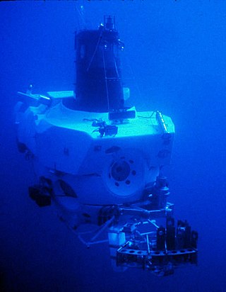
Pisces-class submersibles are three-person research deep-submergence vehicles designed and built by Hyco International Hydrodynamics of North Vancouver in British Columbia with a maximum operating depth of 2,000 m (6,560 ft). The vehicles have multiple view ports and sample collecting, environmental sensing, and instrument placement capabilities. The pressure hull has a 7 ft (2.1 m) inside diameter and is made of HY-100 steel with three forward-looking acrylic windows, 6 in (15 cm) in diameter. Designed by Allan Trice, the Pisces series of submersibles were representative of crewed submersibles built in the late 1960s and were proven workhorses in offshore exploration and oceanographic research. Pisces II was the first production model of the design and was completed in 1968, with nine more Pisces submarines built before the manufacturer went out of business in the late 1970s.
NOAAS Henry B. Bigelow is a fisheries research vessel operated by the United States' National Oceanic Atmospheric Administration (NOAA). She is the second in a class of five new fisheries research vessels. She is named after Henry Bryant Bigelow (1879-1967), the American oceanographer, zoologist, and marine biologist who founded the Woods Hole Oceanographic Institution in Woods Hole, Massachusetts.
ABISMO is a remotely operated underwater vehicle (ROV) built by the Japan Agency for Marine-Earth Science and Technology (JAMSTEC) for exploration of the deep sea. It is the only remaining ROV rated to 11,000-meters, ABISMO is intended to be the permanent replacement for Kaikō, a ROV that was lost at sea in 2003.

A CTD or sonde is an oceanography instrument used to measure the electrical conductivity, temperature, and pressure of seawater. Conductivity is used to determine salinity.
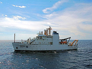
NOAAS Bell M. Shimada is an American fisheries research ship in commission with the National Oceanic and Atmospheric Administration (NOAA) since 2010. She operates along the United States West Coast.

NOAAS Reuben Lasker is a National Oceanic and Atmospheric Administration (NOAA) fishery research vessel. The ship's namesake, Reuben Lasker, was a fisheries biologist who served with the Southwest Fisheries Center, National Marine Fisheries Service, and taught at the Scripps Institution of Oceanography. This class of NOAA ships is very similar to, and based in part upon, the Neil Armstrong-class Oceanographic Research (AGOR) ships owned by the Office of Naval Research and operated by various US Universities.
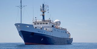
EVNautilus is a 68-meter (223 ft) research vessel owned by the Ocean Exploration Trust under the direction of Robert Ballard, the researcher known for finding the wreck of the Titanic and the German battleship Bismarck. The vessel's home port is at the AltaSea facility in San Pedro in the Port of Los Angeles, California. Nautilus is equipped with a team of remotely operated vehicles (ROVs), Hercules, Argus, Little Hercules, and Atalanta, a multibeam mapping system, and mapping tools Diana and Echo, allowing it to conduct deep sea exploration of the ocean to a depth of 4,000 meters (13,000 ft).

A float is an oceanographic instrument platform used for making subsurface measurements in the ocean without the need for a ship, propeller, or a person operating it. Floats measure the physical and chemical aspects of the ocean in detail, such as measuring the direction and speed of water or the temperature and salinity. A float will descend to a predetermined depth where it will be neutrally buoyant. Once a certain amount of time has passed, most floats will rise back to the surface by increasing its buoyancy so it can transmit the data it collected to a satellite. A float can collect data while it is neutrally buoyant or moving through the water column. Often, floats are treated as disposable, as the expense of recovering them from remote areas of the ocean is prohibitive; when the batteries fail, a float ceases to function, and drifts at depth until it runs aground or floods and sinks. In other cases, floats are deployed for a short time and recovered.
NOAAS Oscar Dyson is an American fisheries and oceanographic research vessel in commission in the National Oceanic and Atmospheric Administration (NOAA) fleet since 2005.

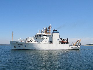
NOAAS Pisces is an American fisheries and oceanographic research vessel in commission in the National Oceanic and Atmospheric Administration (NOAA) fleet since 2009.

A fixed-point ocean observatory is an ocean observing autonomous system of automatic sensors and samplers that continuously gathers data from deep sea, water column and lower atmosphere, and transmits the data to shore in real or near real-time.
Underwater exploration is the exploration of any underwater environment, either by direct observation by the explorer, or by remote observation and measurement under the direction of the investigators. Systematic, targeted exploration is the most effective method to increase understanding of the ocean and other underwater regions, so they can be effectively managed, conserved, regulated, and their resources discovered, accessed, and used. Less than 10% of the ocean has been mapped in any detail, less has been visually observed, and the total diversity of life and distribution of populations is similarly obscure.

Water clarity is a descriptive term for how deeply visible light penetrates through water. In addition to light penetration, the term water clarity is also often used to describe underwater visibility. Water clarity is one way that humans measure water quality, along with oxygen concentration and the presence or absence of pollutants and algal blooms.
 A teacher retrieves a CTD-rosette from the waters of the Bering Strait on the ICESCAPE mission in June 2011.
 Researchers deploy a CTD-rosette at night.
 Researchers watch while a CTD-rosette is lowered into the water from EPA's Bold research vessel.
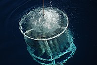 A CTD-rosette is lowered to just under the water surface from NOAA Ship PISCES.
 Technicians prepare a CTD-rosette for sampling by pulling back and securing the cables that hold the Niskin bottles in their open positions. When the rosette is in the water, someone on the ship will remotely trigger sampling, and the circular cable holder at the top of the rosette will release cables, closing the bottles one by one at specific water depths.
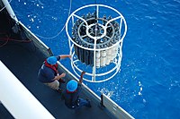 Crew of the NOAA Ship PISCES recover a large CTD-rosette.
 Researchers prepare a CTD-rosette for taking measurements and water samples at the Deep Water Horizon oil spill site.
 A scientist collects water from a Niskin bottles directly into a syringe type filtration container on NOAA Ship PISCES.
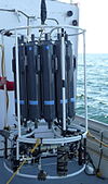 A CTD-rosette is ready for deployment. The top section holds the Niskin bottless while the bottom section holds the CTD instrument and other electronic sensors (such as a fluorometer to measure chlorophyll fluorescence and a transmissometer to measure turbidity).
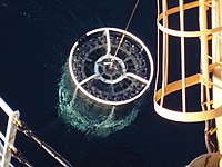 A CTD-rosette comes up out of the water just before it gets recovered and brought on deck of the ship.


