
Whanganui, also spelled Wanganui, is a city in the Manawatū-Whanganui region of New Zealand. The city is located on the west coast of the North Island at the mouth of the Whanganui River, New Zealand's longest navigable waterway. Whanganui is the 19th most-populous urban area in New Zealand and the second-most-populous in Manawatū-Whanganui, with a population of 42,600 as of June 2022.

Manawatū-Whanganui is a region in the lower half of the North Island of New Zealand, whose main population centres are the cities of Palmerston North and Whanganui. It is administered by the Manawatū-Whanganui Regional Council, which operates under the name Horizons Regional Council.

Taumarunui is a small town in the King Country of the central North Island of New Zealand. It is on an alluvial plain set within rugged terrain on the upper reaches of the Whanganui River, 65 km south of Te Kuiti and 55 km west of Turangi. It is under the jurisdiction of Ruapehu District and Manawatū-Whanganui region.

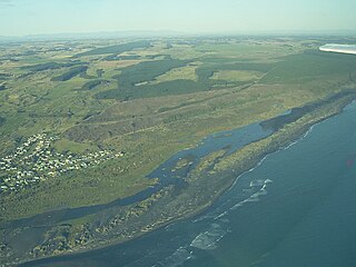
The Whanganui River is a major river in the North Island of New Zealand. It is the country's third-longest river, and has special status owing to its importance to the region's Māori people. In March 2017 it became the world's second natural resource to be given its own legal identity, with the rights, duties and liabilities of a legal person. The Whanganui Treaty settlement brought the longest-running litigation in New Zealand history to an end.

Moutoa Gardens, also known as Pākaitore, is a park in the city of Whanganui, New Zealand. Named after the Battle of Moutoa Island in the Second Taranaki War, it contains a memorial to the battle inscribed "To the memory of the brave men who fell at Moutoa, 14 May 1864, in defence of law and order against fanaticism and barbarism." It also contained a statue of John Ballance, organiser of a volunteer cavalry troop in Tītokowaru's War and later Premier of New Zealand, but the statue was beheaded and a replacement installed outside the district council building. A number of items present in the park are registered by Heritage New Zealand.

Pākaraka, previously known as, Okehu, Maxwelltown, and most recently Maxwell, is a farming and lifestyle community 20 kilometres (12 mi) west of Whanganui, on the North Island of New Zealand.

The Ngāti Tama is a historic Māori tribe of present-day New Zealand. Their origins, according to Maori oral tradition, date back to Tama Ariki, the chief navigator on the Tokomaru waka. They are located in north Taranaki, around Poutama. River Mōhakatino marks their northern boundary with the Tainui and the Ngāti Maniapoto. The close geographical proximity of Tainui's Ngati Toa of Kawhia and the Ngati Mutunga explains the long, continuous, and close relationship among these three tribes.
Western Maori was one of New Zealand's four original parliamentary Māori electorates established in 1868, along with Northern Maori, Eastern Maori and Southern Maori. In 1996, with the introduction of MMP, the Maori electorates were updated, and Western Maori was replaced with the Te Tai Hauāuru and Te Puku O Te Whenua electorates.

The Paddle Steamer Waimarie is an historic riverboat based on the Whanganui River in New Zealand. She is the only coal–fired paddle steamer still operating in New Zealand. Waimarie was built in 1899 by Yarrow & Co. in London and transported to New Zealand in kitset form to be assembled at Whanganui. She operated on the Whanganui River for 49 years before being laid up. In 1952 she sank at her moorings and lay in the mud for the next 40 years.

Hōri Pukehika was a New Zealand Māori tribal leader and woodcarver.

Whanganui High School is a large state co-educational New Zealand secondary school located in Whanganui, New Zealand. Founded in 1958, the school has a roll of 1479 students, including international students as of July 2018, making it the largest school in Whanganui.
Koitiata is a settlement located in the southwestern part of Rangitikei District of the Manawatū-Whanganui region of New Zealand's North Island. At the time of the 2018 census, Koitiata had a population of 126. Marton is located 24 km to the east and Whanganui is located 29 km to the northwest. Nearby Koitiata is Lake Koitiata.

Marutūāhu, Marutūahu or Marutuahu is a collective of the Māori iwi (tribe) of the Hauraki region of New Zealand. The confederation is made up of the tribes of Ngāti Maru, Ngāti Paoa, Ngāti Tamaterā, Ngāti Whanaunga and Ngāti Rongoū.

Hamish McDouall is a New Zealand local government politician and a former mayor of Whanganui. He is a member of the New Zealand Labour Party.
Aramoho is a settlement on the Whanganui River, in the Whanganui District and Manawatū-Whanganui region of New Zealand's North Island. It is an outlying suburb of Whanganui.

Putiki is a settlement in the Whanganui District and Manawatū-Whanganui region of New Zealand's North Island, located across the Whanganui River from Whanganui city. It includes the intersection of State Highway 3 and State Highway 4.
St Johns Hill is a suburb of Whanganui, in the Whanganui District and Manawatū-Whanganui region of New Zealand's North Island.

Durie Hill is a suburb of Whanganui, in the Whanganui District and Manawatū-Whanganui region of New Zealand's North Island.
Whakahoro is a small settlement located south of Taumarunui on the junction of the Retaruke and Whanganui Rivers, about 104 mi (167 km) upstream from Whanganui. By gravel roads it is 41 km (25 mi) west of Raurimu and 44 km (27 mi) south west of Ōwhango.
Pura McGregor, also known as Pura Makarika, was a community leader in Whanganui, New Zealand, and the first Māori woman to receive an MBE. She was of Ngā Poutama, Ngāti Ruāka and Ngāti Rangi descent.

