Route from the Varangians to the Greeks

Last updated
Map showing the major Varangian trade routes: the Volga trade route (in red) and the trade route from the Varangians to the Greeks (in purple). Other trade routes of the 8th to the 11th centuries are shown in orange. Varangian routes.png
Map showing the major Varangian trade routes: the Volga trade route (in red) and the trade route from the Varangians to the Greeks (in purple). Other trade routes of the 8th to the 11th centuries are shown in orange.

The trade route from the Varangians to the Greeks was a medieval trade route that connected Scandinavia, Kievan Rus' and the Eastern Roman Empire. The route allowed merchants along its length to establish a direct prosperous trade with the Empire, and prompted some of them to settle in the territories of present-day Belarus, Russia and Ukraine. The majority of the route comprised a long-distance waterway, including the Baltic Sea, several rivers flowing into the Baltic Sea, and rivers of the Dnieper river system, with portages on the drainage divides. An alternative route was along the Dniester river with stops on the western shore of Black Sea. These more specific sub-routes are sometimes referred to as the Dnieper trade route and Dniester trade route, respectively.

Contents

The route began in Scandinavian trading centers such as Birka, Hedeby, and Gotland, the eastern route crossed the Baltic Sea, entered the Gulf of Finland, and followed the Neva River into Lake Ladoga. Then it followed the Volkhov River upstream past the towns of Staraya Ladoga and Velikiy Novgorod (where it met the Volga trade route and which became a major trade centre), crossed Lake Ilmen, and continued up the Lovat River, the Kunya River and possibly the Seryozha River  [ ru ]. From there, a portage led to the Toropa River  [ ru ] and downstream to the Western Dvina River. From the Western Dvina, the ships went upstream along the Kasplya River and were portaged again to the Katynka River (near Katyn), a tributary of the Dnieper. It seems probable that once the route was established, the goods were unloaded onto land transport to cross the portage and reloaded onto other waiting ships on the Dnieper. Along the Dnieper, the route crossed several major rapids and passed through Kiev. After entering the Black Sea, it followed its west coast to Constantinople. [1]

History

The trade route from the Varangians to the Greeks, according to Marika Magi (In Austrvegr: The Role of the Eastern Baltic in Viking Age Communication across the Baltic Sea, 2018) Kaubateed varjaagide juurest kreeklasteni.gif
The trade route from the Varangians to the Greeks, according to Marika Mägi (In Austrvegr: The Role of the Eastern Baltic in Viking Age Communication across the Baltic Sea, 2018)

The route from the Varangians to the Greeks was first mentioned in the early 12th-century Primary Chronicle (on page 7, line 2), [2] although it does not describe it in detail. [3]

Line Primary Chronicle
Ostrowski et al. (2014) [4] [2003] [3]
English translation
Inés García de la Puente (2010) [5]
7.1Поляномъ же живъшимъ особь по горамъWhen the Polianians lived by themselves among the hills,
7.2симъ, и бѣ путь из Варягъ въ Грьки и изand there was a route from the Varangians to the Greeks and from
7.3Грькъ по Дънѣпру, и вьрхъ Дънѣпра волокъ доthe Greeks along the Dnepr, and above the Dnepr a portage to
7.4Ловоти, и по Ловоти вънити въ Илмерь озероthe Lovat, and along the Lovat one enters the great lake
7.5великое, из негоже озера потечеть Вълховъ, иIlmen, from this lake flows the Volkhov,
7.6вътечеть въ озеро великое Нево, и тогоand it flows into the great lake Nevo [Ladoga], and from this lake
7.7озера вънидеть устие въ море Варяжьское. И поthe outfall flows into the Varangian Sea [Baltic Sea], and along
7.8тому морю вънити доже и до Рима, а отъ Рима прити поthis sea one arrives at Rome, and from Rome one arrives along
7.9томуже морю къ Цьсарюграду, и отъ Цьсаряградаthe same sea at Tsargrad [Constantinople], and from Tsargrad
7.10прити въ Понтъ море, въ неже вътечеть Дънѣпръone enters the Pontic Sea [Black Sea], into which the river Dnepr
7.11рѣка.flows.

But its effects were reported much earlier, in the ninth chapter of Byzantine emperor Constantine VII Porphyrogenitus's book De Administrando Imperio , who noted that the Rhos came down the river Dnieper from Veliky Novgorod, Smolensk, Liubech, Chernigov, Vyshgorod, gathering in Kiev before sailing furhter down the Dnieper towards the Black Sea in June. [3] Though "Varangians" has come to mean "Vikings" to many, the term for the Byzantines meant all Scandinavians and their kindred living in what is now Russia.[ citation needed ]

The route was probably established in the late 8th and early 9th centuries, when Varangian explorers searched for plunder but also for slaves and lucrative goods. The route gained significant importance from the 10th until the first third of the 11th century, concurrently with the Volga trade route and the trade route from the Khazars to the Germans.[ citation needed ]

According to Constantine VII, the Krivichs and other tribes dependent on Kiev transported hollowed-out sailboats, or monoxyla , which could accommodate thirty to forty people, to places along the rivers. These sailboats were then transported along the Dnieper to Kiev. There they were sold to the Varangians who re-equipped them and loaded them with merchandise. [6]

Routes and places

Places named include Smolensk (Μιλινισκα), Liubech (Τελιουτζα), Chernihiv (Τζερνιγωγα), Vyshhorod (Βουσεγραδε), Vitichev  [ pl ] (Βιτετζεβη), and Kiev (Κια[ο]βα). Some of these cities had alternate names in Old Norse, and Constantine quotes some of them: So Novgorod (Νεμογαρδα) is the same as Hólmgarðr (‘Island Enclosure’) and Nýgarðr (‘New Enclosure’); Kiev is equally called Kœnugarðr (‘Boatyard’) or Σαμβατας, which might derive from Norse Sandbakki-áss (‘Sandbank Ridge’). Though Constantin Zuckerman suggests a more obvious etymology, from the Turkic (Khazar) roots sam and bat (literally, ‘upper fortress’). [7] The runestone N 62 preserves the name Vitaholmr (‘demarcation islet’), which could refer to Vitichev, according to Boris Kleiber. [8] Judith Jesch, however, suggests Vitaholmr may refer either to Witland , a historical region on the east side of the River Vistula, [9] or to Vindau on the coast of Courland. [10]

Dnieper route

A coloured copy of runestone G 280 which talks of death in the Dnieper Rapids. G 280, Pilgards (copy).JPG
A coloured copy of runestone G 280 which talks of death in the Dnieper Rapids.

On the Dnieper, the Varangians had to portage their ships around seven rapids, where they had to be on guard from Pecheneg nomads. The rapids began below the modern city of Dnipro, where the river turns south, and fell 50 meters in 66 kilometers. Today, the rapids are underwater, due to the construction of the dam of DniproHES, a hydroelectric power station, in 1932.[ citation needed ]

Below the rapids, they had to pass a narrow rocky spot called the Ford of Vrar (Russian: Krariyskaya crossing), where the Varangians were often attacked by the Pechenegs. The Varangians stopped at St. George Island. Then they equipped their ships with sails in the Dnieper estuary and continued to navigate along the western shore of the Black Sea all the way to Constantinople (Slavic: Tsargrad, Old Norse: Miklagarðr).[ citation needed ]

Western Black Sea shores

The Varangian boats were used along the rivers and along the Black Sea shores. According to Constantine VII, the navigation near the western shore of Black Sea contained stops at Sulina (Danube Delta), Conopa, Constantia (localities today in Romania). There are some remains of the Varangian presence in this area at Murfatlar Cave Complex near Constantia (today Constanţa, Romania). [11] Numerous runic inscriptions, symbols and even a graffiti of a Viking navy are visible on the walls of the rock church from Murfatlar. [12] [13] A rune stone from the Sjonhem cemetery in Gotland dating from the 11th century commemorates a merchant Rodfos who was traveling to Constantinople and was killed north of the Danube by the Blakumenn (Vlachs). [14]

Trade activities

The Trade Route from the Varangians to the Greeks was connected to other waterways of Eastern Europe, such as the Pripyat-Bug waterway leading to Western Europe, and the Volga trade route, which went down the Volga waterway to the Caspian Sea. Another offshoot was along the Dnieper and the Usyazh-Buk River towards Lukoml and Polotsk.[ citation needed ]

The Trade Route from the Varangians to the Greeks was used to transport different kinds of merchandise. Wine, spices, jewelry, glass, expensive fabrics, icons, and books came from the Byzantine Empire. Volhyn traded spinning wheels and other items. Certain kinds of weapons and handicrafts came from Scandinavia. Northern Rus' offered timber, fur, honey, and wax, while the Baltic tribes traded amber.[ citation needed ]

In the second half of the eleventh century, the Crusades opened more lucrative routes from Europe to the Orient through the Crusader states of the Middle East. By that time, Rus' had strengthened its commercial ties with Western Europe, and the route from the Varangians to the Greeks gradually lost its significance. For a related military route, see Muravsky Trail.[ citation needed ]

"Holmgard and beyond
That's where the winds will us guide
For fame and for gold
Set sail for those lands unknown"

Turisas, "To Holmgard and Beyond", The Varangian Way (2007)

See also

Citations

  1. Cybriwsky 2018, p. 45.
  2. García de la Puente 2010, p. 373.
  3. 1 2 3 García de la Puente 2010, p. 374.
  4. Ostrowski & Birnbaum 2014, 7.1–11.
  5. García de la Puente 2010, pp. 373–374.
  6. Waugh 2000.
  7. Zuckerman 2000, p. 117: "C'est alors que débutent des tentatives pour ressusciter le trafic commercial sur le Dniepr, interrompu depuis un demi-siècle, et que commence le développement urbain de Kiev qui aurait aussi porté, selon le De administrando imperio de Constantin Porphyrogénète (952), le nom de Sambatas, sans doute d'origine turco-khazare (sam + bat, fortresse supérieure)."
  8. Pritsak 1981, p. 372: "Kleiber connects viti with the name Vitičev (xolm), for which there is no Slavic etymology, and identifies the first Vitaholm with Vitičev xolm."
  9. Jesch 2001, p. 90: "The secondary inscription on the Alstad stone (N 62) records the death of a man i uitahol(m)(i) ‘in Vitaholmr’, on his way to Russia (see also below). It has been conjectured that this otherwise unidentified place-name has some connection with the Witland, on the east side of the mouth of the River Vistula (NlyR I, 155-7), that is mentioned by Wulfstan in the late ninth century (Lund 1984, 23)."
  10. Jesch 2001, p. 90: "There may or may not be some connection between this and the place called Vindau, on the coast of Kúrland, directly opostite Gotland (SR XI, 271), which is probably mentioned in G 135, in which it is said of the commemorated that he --rþ tauþr a ui(t)au ‘died in Vindau’."
  11. Mihăescu & Ştefan 1970, p. 661.
  12. Spinei 2009, p. 54.
  13. Agrigoroaei 2009.
  14. Curta 2006, p. 303.
  15. DiGioia 2020, p. 85.
  16. Velasco Laguna 2012, p. 168.

Related Research Articles

<span class="mw-page-title-main">Viking Age</span> Period of European history (793–1066)

The Viking Age (793–1066 CE) was the period during the Middle Ages when Norsemen known as Vikings undertook large-scale raiding, colonising, conquest, and trading throughout Europe and reached North America. It followed the Migration Period and the Germanic Iron Age. The Viking Age applies not only to their homeland of Scandinavia but also to any place significantly settled by Scandinavians during the period. The Scandinavians of the Viking Age are often referred to as Vikings as well as Norsemen, although few of them were Vikings in the sense of being engaged in piracy.

<span class="mw-page-title-main">Sviatoslav I</span> Prince of Kiev from 945 to 972

Sviatoslav or Svyatoslav I Igorevich was Prince of Kiev from 945 until his death in 972. He is known for his persistent campaigns in the east and south, which precipitated the collapse of two great powers in Eastern Europe, Khazaria and the First Bulgarian Empire. He conquered numerous East Slavic tribes, defeated the Alans and attacked the Volga Bulgars, and at times was allied with the Pechenegs and Magyars (Hungarians).

<span class="mw-page-title-main">Portage</span> Practice of carrying water craft or cargo over land

Portage or portaging is the practice of carrying water craft or cargo over land, either around an obstacle in a river, or between two bodies of water. A path where items are regularly carried between bodies of water is also called a portage. The term comes from French, where porter means "to carry", as in "portable". In Canada, the term "carrying-place" was sometimes used.

<span class="mw-page-title-main">Dnieper</span> River in Eastern Europe

The Dnieper, also called Dnipro or Dniapro, is one of the major transboundary rivers of Europe, rising in the Valdai Hills near Smolensk, Russia, before flowing through Belarus and Ukraine to the Black Sea. Approximately 2,200 km (1,400 mi) long, with a drainage basin of 504,000 square kilometres (195,000 sq mi), it is the longest river of Ukraine and Belarus and the fourth-longest river in Europe, after the Volga, Danube, and Ural rivers.

<span class="mw-page-title-main">Varangian Guard</span> Elite unit of the Byzantine Army

The Varangian Guard was an elite unit of the Byzantine Army from the tenth to the fourteenth century who served as personal bodyguards to the Byzantine emperors. The Varangian Guard was known for being primarily composed of recruits from northern Europe, including mainly Norsemen from Scandinavia but also Anglo-Saxons from England. The recruitment of distant foreigners from outside Byzantium to serve as the emperor's personal guard was pursued as a deliberate policy, as they lacked local political loyalties and could be counted upon to suppress revolts by disloyal Byzantine factions.

<span class="mw-page-title-main">Berezan Island</span> Island in Mykolaiv Raion, Mykolaiv Oblast, Ukraine

Berezan is an island in the Black Sea at the entrance of the Dnieper-Bug Estuary, Mykolaiv Raion, Mykolaiv Oblast, Ukraine. Located 8 kilometers from the city of Ochakiv and 4 kilometers from the resort village of Rybakivka. It is often being confused with the artificial island of Pervomaisky that is located within Dnieper-Bug Estuary. The Berezan island measures approximately 900 metres in length by 320 metres in width, the height of the northern part is 3-6 metres, the southern part is 21 metres. It is separated from the mainland by about a mile and a half of shallow water. Berezan is an integral part of the historical and archaeological reserve of the National Academy of Sciences of Ukraine "Olvia". The island is uninhabited. In the summer, archaeological expeditions of the IA NASU and the State Hermitage Museum work here. The archaeological site is regularly destroyed as a result of unauthorized excavations.

<span class="mw-page-title-main">Caspian expeditions of the Rus'</span> Military raids from 9th to 11th centuries

The Caspian expeditions of the Rus' were military raids undertaken by the Rus' between the late 9th century and c. 1041 on the Caspian Sea shores, of what are nowadays Iran, Dagestan, and Azerbaijan. Initially, the Rus' appeared in Serkland in the 9th century travelling as merchants along the Volga trade route, selling furs, honey, and slaves. The first small-scale Viking raids took place in the late 9th and early 10th century. The Rus' undertook the first large-scale expedition in 913; having arrived on 500 ships, they pillaged in the Gorgan region, in the territory of present-day Iran, and more to the west, in Gilan and Mazandaran, taking slaves and goods. On their return, the northern raiders were attacked and defeated by the Khazars in the Volga Delta, and those who escaped were killed by the local tribes in the middle Volga.

<span class="mw-page-title-main">Volga trade route</span> Historical trade route that connected Northern Europe with the Caspian Sea

In the Middle Ages, the Volga trade route connected Northern Europe and Northwestern Russia with the Caspian Sea and the Sasanian Empire, via the Volga River. The Rus used this route to trade with Muslim countries on the southern shores of the Caspian Sea, sometimes penetrating as far as Baghdad. The powerful Volga Bulgars formed a seminomadic confederation and traded through the Volga river with Viking people of Rus' and Scandinavia and with the southern Byzantine Empire Furthermore, Volga Bulgaria, with its two cities Bulgar and Suvar east of what is today Moscow, traded with Russians and the fur-selling Ugrians. Chess was introduced to Medieval Rus via the Caspian-Volga trade routes from Persia and Arabia.

<span class="mw-page-title-main">Siege of Constantinople (860)</span> 860 battle of the Rus-Byzantine Wars

The siege of Constantinople of 860 was the only major military expedition of the Rus' Khaganate recorded in Byzantine and Western European sources. The casus belli was the construction of the fortress Sarkel by Byzantine engineers, restricting the Rus' trade route along the Don River in favour of the Khazars. Accounts vary, with discrepancies between contemporary and later sources, and the outcome is unknown in detail.

<span class="mw-page-title-main">Gnezdovo</span> Archeological site in Smolensk Oblast, Russia

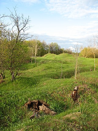
Gnezdovo or Gnyozdovo is an archeological site located near the village of Gnyozdovo in Smolensky District, Smolensk Oblast, Russia. The site contains extensive remains of a Slavic-Varangian settlement that flourished in the 10th century as a major trade station on the trade route from the Varangians to the Greeks.

<span class="mw-page-title-main">Berezan' Runestone</span>

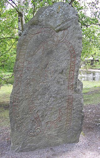
The Berezan' Runestone was discovered in 1905 by Ernst von Stern, professor at Odessa, on Berezan' Island where the Dnieper River meets the Black Sea. The runestone is 48 cm (19 in) wide, 47 cm (19 in) high and 12 cm (4.7 in) thick, and kept in the museum of Odesa. It was made by a Varangian (Viking) trader named Grani in memory of his business partner Karl. They were probably from Gotland, Sweden.

<i>The Varangian Way</i> 2007 studio album by Turisas

The Varangian Way is the second full-length album by the Finnish folk metal band Turisas, released on May 27, 2007 through Century Media. It is a concept album that tells the story of a group of Scandinavians traveling the river routes of medieval Kievan Rus', through Ladoga, Novgorod and Kyiv, down to the Eastern Roman Empire.

<span class="mw-page-title-main">Kylfings</span> People of Northern Europe during the Viking Age

The Kylfings were a people of uncertain origin active in Northern Europe during the Viking Age, roughly from the late ninth century to the early twelfth century. They could be found in areas of Lapland, Russia, and the Byzantine Empire that were frequented by Scandinavian traders, raiders and mercenaries. Scholars differ on whether the Kylfings were ethnically Finnic or Norse. Also disputed is their geographic origin, with Denmark, Sweden and the Eastern Baltic all put forward as candidates. Whether the name Kylfing denotes a particular tribal, socio-political, or economic grouping is also a matter of much debate.

<span class="mw-page-title-main">Rus' people</span> European ethnic group

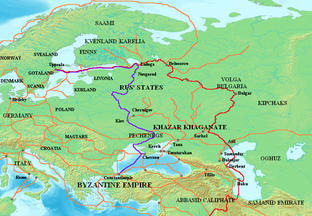
The Rus', also known as Russes, were a people in early medieval Eastern Europe. The scholarly consensus holds that they were originally Norsemen, mainly originating from present-day Sweden, who settled and ruled along the river-routes between the Baltic and the Black Seas from around the 8th to 11th centuries AD. In the 9th century, they formed the state of Kievan Rusʹ, where the ruling Norsemen along with local Finnic tribes gradually assimilated into the East Slavic population, with Old East Slavic becoming the common spoken language. Old Norse remained familiar to the elite until their complete assimilation by the second half of the 11th century, and in rural areas, vestiges of Norse culture persisted as late as the 14th and early 15th centuries, particularly in the north.

Rusʹ Khaganate, or kaganate of Rus is a name applied by some modern historians to a hypothetical polity suggested to have existed during a poorly documented period in the history of Eastern Europe between c. 830 and the 890s.

<span class="mw-page-title-main">Kievan Rus'</span> State in Europe, c. 880 to 1240

Kievan Rus', also known as Kyivan Rus', was a state and later an amalgam of principalities in Eastern and Northern Europe from the late 9th to the mid-13th century. The name was coined by Russian historians in the 19th century. Encompassing a variety of polities and peoples, including East Slavic, Norse, and Finnic, it was ruled by the Rurik dynasty, founded by the Varangian prince Rurik. The modern nations of Belarus, Russia, and Ukraine all claim Kievan Rus' as their cultural ancestor, with Belarus and Russia deriving their names from it, and the name Kievan Rus' derived from what is now the capital of Ukraine. At its greatest extent in the mid-11th century, Kievan Rus' stretched from the White Sea in the north to the Black Sea in the south and from the headwaters of the Vistula in the west to the Taman Peninsula in the east, uniting the East Slavic tribes.

<span class="mw-page-title-main">Varangians</span> Slavic and Greek designation of Vikings

The Varangians were Viking conquerors, traders and settlers, mostly from present-day Sweden. The Varangians settled in the territories of present-day Belarus, Russia and Ukraine from the 8th and 9th centuries, and established the state of Kievan Rus' as well as the principalities of Polotsk and Turov. They also formed the Byzantine Varangian Guard, which later also included Anglo-Saxons.

The Dnieper Rapids also known as Cataracts of the Dnieper were the historical rapids on the Dnieper river in Ukraine, composed of outcrops of granites, gneisses and other types of bedrock of the Ukrainian Shield. The rapids began below the present-day city of Dnipro, where the river turns to the south, and dropped 50 meters in 66 kilometers, ending before the present-day city of Zaporizhzhia.

The Birka textiles are archaeological textiles found during the excavations of Birka, Sweden conducted between 1871 and 1895 by Hjalmar Stolpe. Around 1100 graves were excavated and among the finds were silver brocade tabletwoven bands, embroideries fashion in gold and silver thread and luxury silk textiles, all dating to the 10th century. The embroidery, mostly worked in stem stitch, includes wool floss on wool fabric, silk floss on silk fabric, and gold thread on a decayed ground material. There are examples of appliqué and edging techniques used to decorate and strengthen garments.

<span class="mw-page-title-main">Anti-Normanism</span> Historical revisionist theory

Anti-Normanism is an opposition to Normanism, the mainstream narrative of the Viking Age in Eastern Europe, and concerns the origin theory of Kievan Rus' that emerged in the 18th and 19th centuries. At the centre of the disagreement is the origin of the Varangian Rus', a people who travelled across and settled in Eastern Europe in the 8th and 9th centuries, and are considered by most modern historians to be of Scandinavian origin, but soon assimilated with the Slavs. Since the Normanist theory has been firmly established as mainstream, modern Anti-Normanism is viewed historical revisionism.

References

Further reading