Rutledge, Georgia

Last updated
Rutledge, Georgia
Rutledge, Georgia downtown.jpg
Rutledge downtown
Morgan County Georgia Incorporated and Unincorporated areas Rutledge Highlighted.svg
Location in Morgan County and the state of Georgia
Coordinates: 33°37′33″N83°36′39″W / 33.62583°N 83.61083°W / 33.62583; -83.61083 Coordinates: 33°37′33″N83°36′39″W / 33.62583°N 83.61083°W / 33.62583; -83.61083
Country United States
State Georgia
County Morgan
Area
[1]
  Total3.32 sq mi (8.60 km2)
  Land3.29 sq mi (8.51 km2)
  Water0.04 sq mi (0.09 km2)
Elevation
712 ft (217 m)
Population
 (2020) [2]
  Total871
  Density265.14/sq mi (102.37/km2)
Time zone UTC-5 (Eastern (EST))
  Summer (DST) UTC-4 (EDT)
ZIP code
30663
Area code 706
FIPS code 13-67760 [3]
GNIS feature ID0322022 [4]
Website www.rutledgega.us

Rutledge is a city in Morgan County, Georgia, United States. Founded in 1871, the city had a population of 871 at the 2020 census, [2] up from 781 in 2010.

Contents

History

Rutledge had its start in the 1840s when the railroad was extended to that point. [5] The Georgia General Assembly incorporated Rutledge as a town in 1871. [6]

Geography

Rutledge is located in western Morgan County at 33°37′33″N83°36′39″W / 33.62583°N 83.61083°W / 33.62583; -83.61083 (33.625723, -83.610899). [7] U.S. Route 278 passes through the south side of the city, leading east 9 miles (14 km) to Madison, the county seat, and west 15 miles (24 km) to Covington. Interstate 20 passes 2 miles (3 km) south of Rutledge, with access from Exit 105 (Newborn Road).

According to the United States Census Bureau, the city has a total area of 3.3 square miles (8.5 km2), of which 0.04 square miles (0.10 km2), or 1.05%, are water. [1] The south side of the city is drained by Rice Creek, a tributary of Big Indian Creek, which flows southeast to the Little River. The north side of the city drains to Hard Labor Creek, which flows east to the Apalachee River. The entire city is part of the Oconee River watershed. Rutledge is the nearest town to Hard Labor Creek State Park, 2 miles (3 km) north of the city center.

Demographics

Historical population
CensusPop.
1870 235
1880 27316.2%
1890 588115.4%
1900 469−20.2%
1910 69648.4%
1920 643−7.6%
1930 523−18.7%
1940 5505.2%
1950 482−12.4%
1960 478−0.8%
1970 62831.4%
1980 69410.5%
1990 659−5.0%
2000 7077.3%
2010 78110.5%
2020 87111.5%
U.S. Decennial Census [8]

As of the census [3] of 2000, there were 707 people, 260 households, and 197 families residing in the city. The population density was 215.9 inhabitants per square mile (83.4/km2). There were 280 housing units at an average density of 85.5 per square mile (33.0/km2). The racial makeup of the city was 60.40% White, 38.33% African American, 0.85% Asian, and 0.42% from two or more races. Hispanic or Latino of any race were 0.71% of the population.

There were 260 households, out of which 34.6% had children under the age of 18 living with them, 50.4% were married couples living together, 21.9% had a female householder with no husband present, and 24.2% were non-families. 22.7% of all households were made up of individuals, and 11.9% had someone living alone who was 65 years of age or older. The average household size was 2.72 and the average family size was 3.19.

In the city, the population was spread out, with 27.4% under the age of 18, 9.8% from 18 to 24, 25.3% from 25 to 44, 23.2% from 45 to 64, and 14.3% who were 65 years of age or older. The median age was 36 years. For every 100 females, there were 79.0 males. For every 100 females age 18 and over, there were 72.1 males.

The median income for a household in the city was $35,156, and the median income for a family was $38,875. Males had a median income of $37,750 versus $22,813 for females. The per capita income for the city was $17,732. About 9.9% of families and 9.6% of the population were below the poverty line, including 15.6% of those under age 18 and 0.9% of those age 65 or over.

Economy

Rutledge is a part of the Covington movie industry.[ citation needed ]

Related Research Articles

<span class="mw-page-title-main">Newton County, Georgia</span> County in Georgia, United States

Newton County is a county located in the north central portion of the U.S. state of Georgia. As of the 2020 census, the population was 112,483. The county seat is Covington.

<span class="mw-page-title-main">Morgan County, Georgia</span> County in Georgia, United States

Morgan County is a county located in the north central Piedmont region of the U.S. state of Georgia. As of the 2020 census, the population was 20,097. The county seat is Madison.

<span class="mw-page-title-main">Jackson County, Georgia</span> County in Georgia, United States

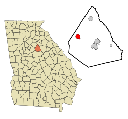
Jackson County is a county located in the northeastern part of the U.S. state of Georgia. As of the 2020 census, the population was 75,907. The county seat is Jefferson.

<span class="mw-page-title-main">Dooly County, Georgia</span> County in Georgia, United States

Dooly County is a county located in the central portion of the U.S. state of Georgia. As of the 2020 census, the population was 11,208. The county seat is Vienna. The county was created by an act of the Georgia General Assembly on May 15, 1821, and named for Colonel John Dooly, a Georgia American Revolutionary War fighter. It was one of the original landlot counties created from land ceded from the Creek Nation.

<span class="mw-page-title-main">Clarke County, Georgia</span> County in Georgia, United States

Clarke County is located in the northeastern part of the U.S. state of Georgia. As of the 2020 census, the population was 128,671. Its county seat is Athens, with which it is a consolidated city-county.

<span class="mw-page-title-main">Union City, Georgia</span> City in Georgia, United States

Union City is a city in Fulton County, Georgia, United States. The population was 19,456 at the 2010 census.

<span class="mw-page-title-main">Hampton, Georgia</span> City in Georgia, United States

Hampton is a city in southwestern Henry County, Georgia, United States. As of the 2010 census, the city had a population of 6,987, up from 3,857 at the 2000 census. By 2018 the estimated population was 7,922. "Hampton" mailing addresses outside the city limits reach into rural parts of eastern Clayton County and northern Spalding County. It is a southeastern suburb in the Atlanta metropolitan area.

<span class="mw-page-title-main">Arcade, Georgia</span> City in Georgia, United States

Arcade is a city in Jackson County, Georgia, United States. As of the 2020 census it had a population of 1,884.

<span class="mw-page-title-main">Gray, Georgia</span> City in Georgia, United States

Gray is a city in Jones County, Georgia, United States. The population was 3,276 at the 2010 census, up from 1,811 at the 2000 census. The city is the county seat of Jones County. It is part of the Macon Metropolitan Area.

<span class="mw-page-title-main">Cadwell, Georgia</span> Town in Georgia, United States

Cadwell is a town in Laurens County, Georgia, United States. The population was 528 at the 2010 census, up from 329 at the 2000 census. It is part of the Dublin Micropolitan Statistical Area.

<span class="mw-page-title-main">Dexter, Georgia</span> Town in Georgia, United States

Dexter is a town in Laurens County, Georgia, United States. As of the 2010 census it had a population of 575, up from 509 at the 2000 census. It is part of the Dublin Micropolitan Statistical Area.

<span class="mw-page-title-main">Lincolnton, Georgia</span> City in Georgia, United States

The city of Lincolnton is the county seat of Lincoln County, Georgia, United States. The population was 1,480 at the 2020 census. It contains numerous houses and historic districts listed on the National Register of Historic Places. Both the city and the county were named for General Benjamin Lincoln, who served in the Continental Army during the American Revolution.

<span class="mw-page-title-main">Colbert, Georgia</span> City in Georgia, United States

Colbert is a city in Madison County, Georgia, United States. The population was 630 at the 2020 census.

<span class="mw-page-title-main">Hull, Georgia</span> City in Georgia, United States

Hull is a city in Madison County, Georgia, United States. The population was 230 at the 2020 census, up from 198 in 2010.

<span class="mw-page-title-main">Luthersville, Georgia</span> City in Georgia, United States

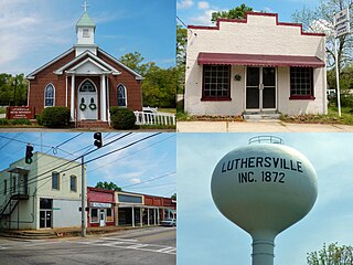
Luthersville is a city in Meriwether County, Georgia, United States. The population was 776 at the 2020 census, down from 874 in 2010.

<span class="mw-page-title-main">Forsyth, Georgia</span> City in Georgia, United States

Forsyth is a city in and the county seat of Monroe County, Georgia, United States. The population was 4,384 at the 2020 census, up from 3,788 in 2010. Forsyth is part of the Macon Metropolitan Statistical Area.

<span class="mw-page-title-main">Bostwick, Georgia</span> Town in Georgia, United States

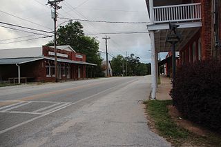
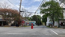
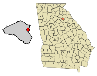
Bostwick is a town in Morgan County, Georgia, United States. As of the 2020 census, the city had a population of 378.

<span class="mw-page-title-main">Young Harris, Georgia</span> City in Georgia, United States

Young Harris is a city in Towns County, Georgia, United States. The population was 899 at the 2010 census. Young Harris is home to Young Harris College, after which it was named.

<span class="mw-page-title-main">Lakeside, Virginia</span> Census-designated area in Virginia

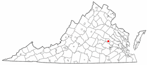
Lakeside is a census-designated place (CDP) in Henrico County, Virginia, United States. It is an inner suburb of Richmond, Virginia. The population was 11,849 at the 2010 census.

<span class="mw-page-title-main">Winterville, Georgia</span> City in Georgia, United States

Winterville is a city in Clarke County, Georgia, United States. The population was 1,122 at the 2010 census.

References

  1. 1 2 "2022 U.S. Gazetteer Files: Georgia". United States Census Bureau. Retrieved January 30, 2023.
  2. 1 2 "P1. Race – Rutledge city, Georgia: 2020 DEC Redistricting Data (PL 94-171)". U.S. Census Bureau. Retrieved January 30, 2023.
  3. 1 2 "U.S. Census website". United States Census Bureau . Retrieved 2008-01-31.
  4. "US Board on Geographic Names". United States Geological Survey. 2007-10-25. Retrieved 2008-01-31.
  5. "Rutledge". GeorgiaInfo. Retrieved 28 May 2019.
  6. Krakow, Kenneth K. (1975). Georgia Place-Names: Their History and Origins (PDF). Macon, GA: Winship Press. p. 194. ISBN   0-915430-00-2.
  7. "US Gazetteer files: 2010, 2000, and 1990". United States Census Bureau. 2011-02-12. Retrieved 2011-04-23.
  8. "Census of Population and Housing". Census.gov. Retrieved June 4, 2015.