
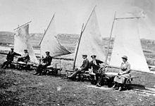
A sail bogey or sail trolley is a wind-driven vehicle that runs along railway tracks. [1]
A sail bogey or sail trolley is a wind-driven vehicle that runs along railway tracks. [1]
The Spurn railway, built along Spurn Head on the Yorkshire coast of England was built in the First World War and ran until the early 1950s and included sail bogies as part of its rolling stock. [2]
In the early days of the Teesmouth lifeboat, its crew were sometimes able, subject to wind conditions, to travel out to the lifeboat station at South Gare on a sail bogey. [3]
In the 1930s, the US government investigated using rotating vertically-mounted cylinders (90-ft tall by 22.2-ft Dia) mounted on a rake of flatcars in a closed loop on a circular track to generate electricity. The project, known as the "The Madaras Rotor Power Plant", used the Magnus Effect to transfer the wind energy into thrust to accelerate the "Train" whilst alternators fitted to the axles of the flatcars generated electricity which was fed back to the system through a trolley system.
Other locations to have used sail bogies include:

More recently, in 2005, a replica of a 19th-century sail bogey was built and demonstrated on the Ffestiniog Railway in North Wales. [5] [6] [7]

A bogie is a chassis or framework that carries a wheelset, attached to a vehicle—a modular subassembly of wheels and axles. Bogies take various forms in various modes of transport. A bogie may remain normally attached or be quickly detachable. It may include a suspension component within it, or be solid and in turn be suspended ; it may be mounted on a swivel, as traditionally on a railway carriage or locomotive, additionally jointed and sprung, or held in place by other means.

Spurn is a narrow sand tidal island located off the tip of the coast of the East Riding of Yorkshire, England that reaches into the North Sea and forms the north bank of the mouth of the Humber Estuary. It was a spit with a semi-permanent connection to the mainland, but a storm in 2013 made the road down to the end of Spurn impassable to vehicles at high tide.

Herne Bay is a seaside town on the north coast of Kent in South East England. It is 6 miles (10 km) north of Canterbury and 4 miles (6 km) east of Whitstable. It neighbours the ancient villages of Herne and Reculver and is part of the City of Canterbury local government district, although it remains a separate town with countryside between it and Canterbury. Herne Bay's seafront is home to the world's first freestanding purpose-built Clock Tower, built in 1837. From the late Victorian period until 1978, the town had the second-longest pier in the United Kingdom.

The Newfoundland Railway was a narrow-gauge railway that operated on the island of Newfoundland from 1898 to 1988. With a total track length of 906 miles (1,458 km), it was the longest 3 ft 6 in narrow-gauge system in North America.

Dagebüll is a municipality located at the west coast of Schleswig-Holstein in the Nordfriesland district, Germany. Today's Dagebüll was created in 1978 as a merger of the municipalities of Fahretoft, Juliane-Marien-Koog and Waygaard. Dagebüll used to be a Hallig, the oldest houses were built on artificial dwelling hills which in parts can still be seen today. In 1704 the area was secured by sea dikes.

The German Bight is the southeastern bight of the North Sea bounded by the Netherlands and Germany to the south, and Denmark and Germany to the east. To the north and west it is limited by the Dogger Bank. The Bight contains the Frisian and Danish Islands. The Wadden Sea is approximately ten to twelve kilometres wide at the location of the German Bight. The Frisian islands and the nearby coastal areas are collectively known as Frisia. The southern portion of the bight is also known as the Heligoland Bight. Between 1949 and 1956 the BBC Sea Area Forecast used "Heligoland" as the designation for the area now referred to as German Bight.

A railway gun, also called a railroad gun, is a large artillery piece, often surplus naval artillery, mounted on, transported by, and fired from a specially designed railway wagon. Many countries have built railway guns, but the best-known are the large Krupp-built pieces used by Germany in World War I and World War II. Smaller guns were often part of an armoured train. Only able to be moved where there were good tracks, which could be destroyed by artillery bombardment or airstrike, railway guns were phased out after World War II.

A flatcar (US) is a piece of rolling stock that consists of an open, flat deck mounted on a pair of trucks (US) or bogies (UK), one at each end containing four or six wheels. Occasionally, flat cars designed to carry extra heavy or extra large loads are mounted on a pair of bogies under each end. The deck of the car can be wood or steel, and the sides of the deck can include pockets for stakes or tie-down points to secure loads. Flatcars designed for carrying machinery have sliding chain assemblies recessed in the deck.
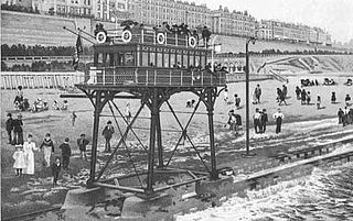
The Brighton and Rottingdean Seashore Electric Railway was a unique coastline railway in Brighton, England, that ran through the shallow coastal waters of the English Channel between 1896 and 1901. It was designed by Magnus Volk to extend his Volk's Electric Railway from its terminus in Paston Place to the village of Rottingdean and avoid difficult terrain. While the unique railway was popular and carried tens of thousands of passengers, it was ultimately abandoned to make room for new sea defences, and Volk was unable to raise the funds to construct a replacement.
Margate was a "limb" of Dover in the ancient confederation of the Cinque ports. It was added to the confederation in the 15th century.

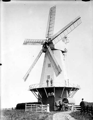
Herne Windmill is a Grade I listed smock mill in Herne, Kent, England, that was built in 1789.
St Margaret's Bay Windmill is a Grade II listed Smock mill on South Foreland, the southeasternmost point of England. It was built in 1929 to generate electricity for the attached house, high on the White Cliffs of Dover.
Ringle Crouch Green Mill is a smock mill in Sandhurst, Kent, England, that was demolished to base level in 1945, and now has a new smock tower built on it as residential accommodation and an electricity generator.

Herne Bay Pier was the third pier to be built at Herne Bay, Kent for passenger steamers. It was notable for its length of 3,787 feet (1,154 m) and for appearing in the opening sequence of Ken Russell's first feature film French Dressing. It was destroyed in a storm in 1978 and dismantled in 1980, leaving a stub with sports centre at the landward end, and part of the landing stage isolated at sea. It was preceded by two piers: a wooden deep-sea pier designed by Thomas Rhodes, assistant of Thomas Telford, and a second shorter iron version by Wilkinson & Smith.

South Gare is an area of reclaimed land and breakwater on the southern side of the mouth of the River Tees in Redcar and Cleveland, England. It is accessed by taking the South Gare Road from Fisherman's Crossing at the western end of Tod Point Road in Warrenby.
A flatbed trolley a common form of freight transport in distribution environments, for moving bulk loads. Trolleys can aid in reducing effort required to move a load by allowing the user to pull or push instead of lift and carry. A very simple design offers a basic flat platform with four casters and a fixed handle which is used to either push or pull the platform with the load on the platform. Without a flat surface it becomes an open frame trolley and without a handle it is a bogie or dolly.
An electric tug is a battery-powered and pedestrian-operated machine used to move heavy loads on wheels.

The Spurn Point military railway was a railway line in the East Riding of Yorkshire, England. It extended for 3+3⁄4 miles (6 km), connecting Kilnsea with Spurn Point in the Humber Estuary. The line was built to supply military installations along this stretch of coast.

The Humber Lifeboat Station originally was located on Spurn Point in the East Riding of Yorkshire, England, but now is located in Grimsby. The station was one of nine Royal National Lifeboat Institution (RNLI) lifeboat stations situated along the Yorkshire Coast and the most southerly of them all.

Teesmouth Lifeboat Station was a Royal National Lifeboat Institution (RNLI) lifeboat station, situated on the mouth of the River Tees, South Gare, North Yorkshire, England. The lifeboat station had been operating at Teesmouth for 177 years when it was closed by the RNLI in 2006. The withdrawal of the lifeboat capability from Teesmouth was subject to much criticism from the local council and the volunteers who crewed the boat, but the RNLI stated that there was an over-provision of lifeboat cover on the north-east coast.
| | This article about transport is a stub. You can help Wikipedia by expanding it. |