
Asientos is a municipality in the Mexican state of Aguascalientes. It stands at 22°14′N102°05′W. The town of Real de Asientos serves as the municipal seat for the surrounding municipality of Asientos.

Jilotepec de Molina Enríquez, known as Jilotepec de Abasolo until 1986, and commonly known as Jilotepec, is a city located in the northwest zone of the State of Mexico in Mexico. The name comes from Náhuatl, meaning "hill of corncobs". It is the municipal seat and largest city of the municipality of Jilotepec. It is located in hilly and forested terrain about an hour's drive from Mexico City and the state capital of Toluca, 40 minutes from San Juan del Río, 30 minutes from Tula and 20 minutes from Tepeji. The Mexico City–Querétaro highway and the new Transoceanic Freeways that unite the coasts of Mexico from Veracruz to Michoacán converge within its territory.

Buenaventura is one of the 67 municipalities of Chihuahua, in northern Mexico. The municipal seat lies at San Buenaventura. The municipality covers an area of 8,938.3 km².

Janos is a municipality in the Mexican state of Chihuahua. It is located in the extreme northwest of Chihuahua, on the border with the state of Sonora and the U.S. states of Arizona & New Mexico. As of 2010, the municipality had a total population of 10,953. The municipal seat is the town of Janos, Chihuahua, which shares its name with the municipality.

Tequixquiac is a municipality located in the Zumpango Region of the State of Mexico in Mexico. The municipality is located 84 kilometres (52 mi) north of Mexico City within the valley that connects the Valley of Mexico with the Mezquital Valley. The name comes from Nahuatl and means "place of tequesquite waters". The municipal seat is the town of Santiago Tequixquiac, although both the town and municipality are commonly referred to as simply "Tequixquiac".
San Andrés Larráinzar is a town in the Mexican state of Chiapas. It serves as the municipal seat for the surrounding municipality of Larráinzar.

Ajacuba is a town and one of the 84 municipalities of Hidalgo, in central Mexico. The municipality covers an area of 192.7 km².
Zimapán is a town and one of the 84 municipalities of Hidalgo, in central-eastern Mexico. The municipality covers an area of 860.9 km2 (332.4 sq mi).

Mascota is a town and municipality in Jalisco, in central-western Mexico. The municipality covers an area of 1,843 km2. The name Mascota comes from the root "Amaxacotlán", which means "place of deer and colubrids".
Santiago Minas is a town and municipality in Oaxaca in south-western Mexico. The municipality covers an area of km².
San Gregorio Atzompa is a municipality in the Mexican state of Puebla in south-eastern Mexico.

San Salvador Huixcolotla is a town and municipality in the Mexican state of Puebla in southeastern Mexico that may be best known as the birthplace of papel picado. San Salvador is of Spanish origin and translates to "Holy Savior" and Huixcolotla is Nahuatl for "place of the curved spines".
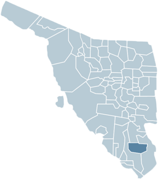
Quiriego Municipality is a municipality of southern Sonora state, in northwestern Mexico.

Arroyo Seco Municipality is a municipality in the Mexican state of Querétaro in central Mexico.

Axtla de Terrazas is one of the 58 municipalities in the Mexican state of San Luis Potosí in central Mexico. The municipality was founded 1826, its name comes from Nahuatl (astlan) and is interpreted as: "Place of white herons", it was added de Terrazas in honor of the revolutionary Alfredo M. Terrazas.
Charcas is a town and municipality in the Mexican state of San Luis Potosí in central Mexico. The municipality covers an area of 4.911 km2. As of 2020, the municipality had a total population of 14,117 people. Charcas is just south of the Tropic of Cancer. Due to its elevation of 2,219 metres (7,280 ft), the climate is mild.

Municipality of Badiraguato is a municipality in the Mexican state of Sinaloa in northwestern Mexico. The seat of the municipality is in the small town of Badiraguato.

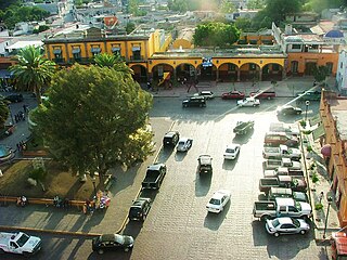
Janos is a town located in the northern Mexican state of Chihuahua. It serves as the municipal seat of government for the surrounding Janos Municipality of the same name. As of 2010, the town of Janos had a population of 2,738. Janos was possibly the site of a Franciscan mission established about 1640 and destroyed by Indian attack in the 1680s. The Spanish established a fort in Janos in 1686 which became a key element in the Spanish attempt to suppress raids and attacks by the Apache people. Several hundred Apaches often lived near the presidio during the late 18th and early 19th centuries.

