San Fernando, Chile

Last updated
San Fernando
Plaza San Fernando (Chile).jpg
San Fernando's central plaza.


Escudo de San Fernando (Chile).svg
Comuna de San Fernando.svg
Chile location map.svg
Red pog.svg
San Fernando
Location in Chile
Coordinates(city): 34°35′S70°59′W / 34.583°S 70.983°W / -34.583; -70.983
Country Flag of Chile.svg Chile
Region Flag of O'Higgins Region, Chile.svg O'Higgins
Province Logo de la Gobernacion de Colchagua.svg Colchagua
Founded1742
Founded byJosé Antonio Manso de Velasco
Government
[1]
  Type Municipality
   mayor Pablo Silva Pérez (Independent)
Area
[2]
  Total2,441.3 km2 (942.6 sq mi)
Elevation
89 m (292 ft)
Population
 (2017 Census) [2]
  Total73,973
  Density30/km2 (78/sq mi)
Demonym Sanfernandino/a
Sex
[2]
  Men36,077
  Women37,896
Time zone UTC-4 (CLT [3] )
  Summer (DST) UTC-3 (CLST [4] )
Postal code
3070000
Area code +56 72
Website Official website (in Spanish)

San Fernando is the capital of the province of Colchagua, in central Chile, and the second most populated urban center of the O'Higgins Region. Located close to the Tinguiririca River (a tributary of the Rapel) in a fertile valley, San Fernando sits 339 m (1,112 feet) above sea level. Founded in 1742, it became the provincial capital in 1840.

Contents

Culture

San Fernando is famous for its rodeos, thanks to its location at the heart of the country. The surrounding area yields wheat, forage crops, rice, legumes and grapes. There is also a brand of Chilean wine called San Fernando. Both the Pan-American Highway and Chile's main longitudinal railroad run through San Fernando.

San Fernando is located at the northern tip of Chile's Colchagua Valley. This region is popularly known as the heart of chilean agriculture. Here you can find the "wine route" which will take visitors on a journey from San Fernando to Santa Cruz, visiting some of Chile's most traditional vineyards.

Some major attractions in and around San Fernando include Casa Silva, a hotel, vineyard, and winery. Hacienda Los Lingues, a traditional chilean-style, colonial home of an hacienda "patrón" or owner that has been turned into a hotel and restaurant. The hacienda offers horseback riding adventures into the precordillera of the Andes.

Most major producers of fresh fruit for export are located in and around San Fernando. These include: Frusan, Unifruti, and Agricola Panagro. Within the orchards and farms of the region one can find almost every type of fresh produce; from citrus to premium quality fresh cherries.

San Fernando is also the point of departure to begin a trip to "Las Termas Del Flaco" (The thermal baths of Flaco). Flaco can be reached by travelling east of ruta 5 on the road to Puente Negro. "Las Termas" baths are open from mid-December to April and are located in an area famous for its large populations of Tricahues, a type of native parrot, [5] and fossilized dinosaur footprints.

Demographics

According to the 2017 census of the National Statistics Institute, San Fernando spans an area of 2,441.3 km2 (943 sq mi) and has 73,973 inhabitants (36,077 men and 37,896 women). The population grew by 16.1% (11,881 persons) between the 2002 and 2017 censuses. [2]

Administration

As a commune, San Fernando is a third-level administrative division of Chile administered by a municipal council, headed by a mayor who is democratically elected every four years. The current administration is run by Pablo Silva Pérez (right-wing independent) who was elected in the 2021 Chilean municipal elections.

Climate

Climate data for Rengo
MonthJanFebMarAprMayJunJulAugSepOctNovDecYear
Mean daily maximum °C (°F)29.8
(85.6)
28.8
(83.8)
26.2
(79.2)
22.1
(71.8)
18.8
(65.8)
14.0
(57.2)
13.8
(56.8)
14.2
(57.6)
18.4
(65.1)
21.7
(71.1)
24.0
(75.2)
28.3
(82.9)
21.7
(71.0)
Daily mean °C (°F)21.4
(70.5)
20.2
(68.4)
17.0
(62.6)
13.6
(56.5)
10.5
(50.9)
7.6
(45.7)
7.9
(46.2)
8.5
(47.3)
11.3
(52.3)
14.4
(57.9)
16.7
(62.1)
20.1
(68.2)
14.1
(57.4)
Mean daily minimum °C (°F)12.8
(55.0)
11.6
(52.9)
9.0
(48.2)
6.7
(44.1)
5.4
(41.7)
2.5
(36.5)
3.2
(37.8)
3.6
(38.5)
5.0
(41.0)
7.7
(45.9)
9.5
(49.1)
11.5
(52.7)
7.4
(45.3)
Average precipitation mm (inches)5.4
(0.21)
9.3
(0.37)
9.2
(0.36)
16.6
(0.65)
98.7
(3.89)
157.6
(6.20)
118.2
(4.65)
100.4
(3.95)
38.9
(1.53)
24.3
(0.96)
18.7
(0.74)
3.4
(0.13)
600.7
(23.64)
Average relative humidity (%)61627076848584847774696074
Source: Bioclimatografia de Chile [6]

Related Research Articles

<span class="mw-page-title-main">Chilean wine</span> Wine making in Chile

Chile has a long history in the production of wine, with roots dating back to the 16th century when the Spanish conquistadors introduced Vitis vinifera vines to the region. In the mid-19th century, French wine varieties such as Cabernet Sauvignon, Merlot, Carmenère, and Franc were introduced. During the early 1980s, the Chilean wine industry underwent a renaissance with the introduction of stainless steel fermentation tanks and the use of oak barrels for aging. This led to a rapid growth in exports as quality wine production increased. The number of wineries in Chile rose from 12 in 1995 to over 70 in 2005.

<span class="mw-page-title-main">O'Higgins Region</span> Region of Chile

The Libertador General Bernardo O'Higgins Region, often shortened to O'Higgins Region, is one of Chile's 16 first order administrative divisions. It is subdivided into three provinces. It is named in honour of Bernardo O'Higgins Riquelme, one of Chile's founding fathers.

<span class="mw-page-title-main">Maule Region</span> Region of Chile

The Maule Region is one of Chile's 16 first order administrative divisions. Its capital is Talca. The region derives its name from the Maule River which, running westward from the Andes, bisects the region and spans a basin of about 20,600 km2. The Maule river is of considerable historic interest because, among other reasons, it marked the southern limits of the Inca Empire.

<span class="mw-page-title-main">Parral, Chile</span> City and Commune in Maule, Chile

Parral is a city and commune in the Linares Province of Chile's Maule Region.

<span class="mw-page-title-main">Rancagua</span> City and commune in OHiggins Region, Chile

Rancagua is a city and commune in central Chile and part of the Rancagua conurbation. It is the capital of the Cachapoal Province and of the O'Higgins Region, located 87 km (54 mi) south of the national capital of Santiago.

<span class="mw-page-title-main">Curicó Province</span> Province in Maule, Chile

Curicó Province is one of four provinces of the central Chilean region of Maule (VII). Its capital is the city of Curicó. It lies between the provinces of Colchagua and Talca and extends from the Pacific to the Argentine frontier, spanning an area of 7,280.9 km2 (2,811 sq mi). According to the 2002 census, the population was 244,053.

<span class="mw-page-title-main">Curicó</span> City and Commune in Maule, Chile

Curicó is a city located in Chile's central valley and serves as the capital of the Curicó Province, which is part of the Maule Region. Positioned between the provinces of Colchagua and Talca, the region stretches from the Pacific Ocean to the border with Argentina.

<span class="mw-page-title-main">Maipo Province</span> Province in Santiago Metropolitan, Chile

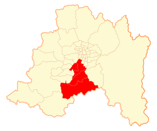
Maipo Province is one of six provinces in the Santiago Metropolitan Region of central Chile. Its capital is San Bernardo.

<span class="mw-page-title-main">Colchagua Province</span> Province in OHiggins, Chile

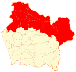
Colchagua Province is one of three provinces of the central Chilean region of O'Higgins (VI). Its capital is San Fernando. It is bordered on the north by Cachapoal Province, on the east by the Argentine Republic, on the south by Curicó Province, and on the west by Cardenal Caro Province.

<span class="mw-page-title-main">Malleco Province</span> Province in La Araucanía, Chile

Malleco Province is one of two provinces in the southern Chilean region of La Araucanía (IX). Its population as of the 2017 census is 205,124, and it covers an area of 13,433.3 km2 (5,187 sq mi). The provincial capital is the city of Angol.

<span class="mw-page-title-main">Cafayate</span> Town in Salta, Argentina

Cafayate is a town located at the central zone of the Valles Calchaquíes in the province of Salta, Argentina. It sits 1,683 metres (5,522 ft) above mean sea level, at a distance of 189 kilometres (117 mi) from Salta City and 1,329 kilometres (826 mi) from Buenos Aires. It has about 12,000 inhabitants.

<span class="mw-page-title-main">Lolol</span> Town in OHiggins, Chile

Lolol is a Chilean commune and town in Colchagua Province, O'Higgins Region.

<span class="mw-page-title-main">Cachapoal Province</span> Province in Libertador General Bernardo OHiggins Region, Chile

Cachapoal Province is one of three provinces of the central Chilean region of O'Higgins (VI). Its capital is the city of Rancagua.

Melipilla is a Chilean commune and capital city of the province of the same name. It is part of the Santiago Metropolitan Region and is a significant satellite city of the Chilean capital.

<span class="mw-page-title-main">San Antonio, Chile</span> City and main freight port of Chile

San Antonio is a Chilean port city, commune, and the capital of the San Antonio Province in the Valparaíso Region. It has become the main freight port in Chile, surpassing Valparaíso in the 21st century. San Antonio is also the hub of the fishing area that stretches along the Chilean coast from Rocas de Santo Domingo to Cartagena.

<span class="mw-page-title-main">Santa Cruz, Chile</span> City and commune in OHiggins, Chile

Santa Cruz is a Chilean city and commune, located in the Colchagua valley, in the O'Higgins Region, located on the southern shore of the Tinguiririca river, 110 miles from Santiago, Chile's capital city, and 27 miles from San Fernando.

<span class="mw-page-title-main">CD Colchagua</span> Chilean football club

Colchagua Club de Deportes or just Colchagua is a chilean Football club, their home town is San Fernando in Chile. They currently play in the Tercera Division A of Chilean football, which is actually the fourth division on chilean football due to ANFP ruling. Its traditional rivals are Rancagua Sur and O'Higgins both from the city of Rancagua in the O'Higgins Region which is where San Fernando is also located, it also has rivalry with General Velásquez from the nearby town of San Vicente and with Deportes Santa Cruz. They also share some kind of brotherhood and «healthy» rivalry at the same time with Curicó Unido from the city of Curicó in the Maule Region, this is because San Fernando and Curicó are both pretty close to the regional border between O'Higgins and Maule, both cities are approximately 45 minutes away from each other, so when the La Granja stadium started it's reconstruction during early 2010, Colchagua let Curicó Unido play as local at the Jorge Silva Valenzuela stadium in San Fernando, these two teams dispute the Clásico Huaso because both teams are located in the denominated Zona Huasa of the country.

Cono Sur Vineyards & Winery is a subsidiary of Concha y Toro Winery and is the third largest exporter of bottled wine in Chile. Established in 1993, its name is a reference to its location in the Southern Cone of South America and a play on the word connoisseur. In 2015, it was the official wine of the Tour de France.

<span class="mw-page-title-main">History of Pichilemu</span>

The history of Pichilemu began around the 16th century, when Promaucaes inhabited the modern Pichilemu region. According to Chilean historiographer José Toribio Medina on his book Los Restos Indígenas de Pichilemu (1908), Spanish conqueror Pedro de Valdivia gave Topocalma encomienda, in which Pichilemu was supposed to be, to Juan Gómez de Almagro, on January 24, 1544.

<span class="mw-page-title-main">Pichilemu</span> City in OHiggins, Chile

Pichilemu, originally known as Pichilemo, is a beach resort city and commune in central Chile, and capital of Cardenal Caro Province in the O'Higgins Region. The commune comprises an urban centre and twenty-two villages, including Ciruelos, Cáhuil, and Cardonal de Panilonco. It is located southwest of Santiago. Pichilemu had over 13,000 residents as of 2012.

References

  1. "Municipality of San Fernando" (in Spanish). Retrieved 13 December 2010.
  2. 1 2 3 4 "National Statistics Institute" (in Spanish). Retrieved 20 February 2018.
  3. "Chile Time". WorldTimeZones.org. Archived from the original on 2007-09-11. Retrieved 2010-07-28.
  4. "Chile Summer Time". WorldTimeZones.org. Archived from the original on 2007-09-11. Retrieved 2010-07-28.
  5. "Anacondaweb - Servicio Suspendido".
  6. Hajek, Ernst; Castri, Francesco (1975). "Bioclimatografia de Chile" (PDF) (in Spanish). Archived from the original (PDF) on 22 November 2009. Retrieved 27 May 2024.