
The Spanish missions in California formed a series of 21 religious outposts or missions established between 1769 and 1833 in what is now the U.S. state of California. The missions were established by Catholic priests of the Franciscan order to evangelize indigenous peoples backed by the military force of the Spanish Empire. The missions were part of the expansion and settlement of New Spain through the formation of Alta California, expanding the empire into the most northern and western parts of Spanish North America. Civilian settlers and soldiers accompanied missionaries and formed settlements like the Pueblo de Los Ángeles.
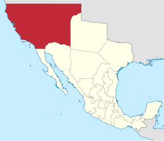
Alta California, also known as Nueva California among other names, was a province of New Spain formally established in 1804. Along with the Baja California peninsula, it had previously comprised the province of Las Californias, but was made a separate province in 1804. Following the Mexican War of Independence, it became a territory of Mexico in April 1822 and was renamed Alta California in 1824.

Agua Fria is a census-designated place (CDP) in Santa Fe County, New Mexico, United States. It is part of the Santa Fe, New Mexico Metropolitan Statistical Area. The population was 2,800 at the 2010 census. Agua Fria Village is a "Traditional Historic Community" (THC) as designated by the Santa Fe Board of County Commissioners in 1995 and subsequent Santa Fe County Ordinance #1996-16, as allowed by State Statute.

Santa Cruz, historically known as Santa Cruz de la Cañada, is a census-designated place (CDP) in Santa Fe County, New Mexico, United States. It is part of the Santa Fe, New Mexico Metropolitan Statistical Area. The population was 423 at the 2000 census.

Floresville is a city in Wilson County, Texas, United States. According to the U.S. Census Bureau, its population was at 7,203 at the 2020 Census. It is the county seat of Wilson County. The city is also part of the San Antonio metropolitan statistical area.

Tejanos are Spanish Creoles from Texas. The term is also sometimes applied to Texans of Mexican descent.

Maní is a small city in Maní Municipality in the central region of the Yucatán Peninsula, in the Mexican state of Yucatán. It is about 100 km to the south south-east of Mérida, Yucatán, some 16 km east of Ticul. The village of Tipikal lies 6 km to the east.

Zitácuaro, officially known as Heroica Zitácuaro, is a city in the Mexican state of Michoacán. The city is the administrative centre for the surrounding municipality of the same name, which lies at the extreme eastern side of Michoacán and borders on the adjacent state of México. The city reported a population of 185,534 in the 2010 census. The municipality has an area of 498 km2. The name Zitácuaro comes from Mazahua Tsitákuarhu.

Juan Nepomuceno Álvarez Hurtado de Luna, generally known as Juan Álvarez, was a general, long-time caudillo in southern Mexico, and president of Mexico for two months in 1855, following the liberals' ouster of Antonio López de Santa Anna. His presidency inaugurated the pivotal era of La Reforma.

Juan Bautista Loreto Mucio Francisco José de Asís de la Santísima Trinidad Ceballos Gómez Sañudo was a Mexican politician who served in congress and in the supreme court before being briefly made president after the resignation of President Mariano Arista during a revolution known as the Plan of Jalisco in 1853. He failed to come to any sort of arrangements with the insurgents and resigned after only about a month of serving and went back to his seat on the supreme court. After being removed from the court by the restored Santa Anna, he left the country and died in Paris in 1859.
Trinidad Anastasio de Sales Ruiz Bustamante y Oseguera was a Mexican physician, general, and politician who served as the 4th President of Mexico three times from 1830 to 1832, 1837 to 1839, and 1839 to 1841. He also served as the 2nd Vice President of Mexico from 1829 to 1832 under Presidents Vicente Guerrero, José María Bocanegra, himself, and Melchor Múzquiz. He participated in the Mexican War of Independence initially as a royalist before siding with Agustín de Iturbide and supporting the Plan of Iguala.

The Californias, occasionally known as The Three Californias or Two Californias, are a region of North America spanning the United States and Mexico, consisting of the U.S. state of California and the Mexican states of Baja California and Baja California Sur. Historically, the term Californias was used to define the vast northwestern region of Spanish America, as the Province of the Californias, and later as a collective term for Alta California and the Baja California Peninsula.

Beginning in the second half of the 16th century, the Kingdom of Spain established a number of missions throughout La Florida in order to convert the Native Americans to Christianity, to facilitate control of the area, and to prevent its colonization by other countries, in particular, England and France. Spanish Florida originally included much of what is now the Southeastern United States, although Spain never exercised long-term effective control over more than the northern part of what is now the State of Florida from present-day St. Augustine to the area around Tallahassee, southeastern Georgia, and some coastal settlements, such as Pensacola, Florida. A few short-lived missions were established in other locations, including Mission Santa Elena in present-day South Carolina, around the Florida peninsula, and in the interior of Georgia and Alabama.

San Mateo Atenco is one of 125 municipalities in the State of México in Mexico. The municipal seat is the town of San Mateo Atenco. It lies west of the Federal District near the municipality of Metepec, in the central part of the state of México, and is part of the Toluca urban area bordering the city to the east. The name Atenco is derived from the Nahuatl language. It means “In the water’s edge”, from atl(water), tentli (edge) and co (in).
Santa Elena, a Spanish settlement on what is now Parris Island, South Carolina, was the capital of Spanish Florida from 1566 to 1587. It was established under Pedro Menéndez de Avilés, the first governor of Spanish Florida. There had been a number of earlier attempts to establish colonies in the area by both the Spanish and the French, who had been inspired by the earlier accounts by Chicora and Hernando de Soto of rich territories in the interior. Menéndez's Santa Elena settlement was intended as the new capital of the Spanish colony of La Florida, shifting the focus of Spanish colonial efforts north from St. Augustine, which had been established in 1565 to oust the French from their colony of Fort Caroline. Santa Elena was ultimately built at the site of the abandoned French outpost of Charlesfort, founded in 1562 by Jean Ribault.
Zumpuhuacán is a municipality in the State of Mexico. Its municipal seat is also called Zumpahuacán: The area was settled by Mexicas in 1220.
The Second Federal Republic of Mexico refers to the period of Mexican history involving a second attempt to establish a federal government in Mexico after the fall of the unitary Centralist Republic of Mexico in 1846 at the start of the Mexican-American War. It would last up until the Second French Intervention in Mexico led to the proclamation of the Second Mexican Empire in 1863.

The Centralist Republic of Mexico, or in the anglophone scholarship, the Central Republic, officially the Mexican Republic, was a unitary political regime established in Mexico on 23 October 1835, under a new constitution known as the Siete Leyes after conservatives repealed the federalist Constitution of 1824 and ended the First Mexican Republic. It would ultimately last until 1846 when the Constitution of 1824 was restored at the beginning of the Mexican-American War.
The following is a timeline of the history of the city of Chihuahua, Mexico.
The following is a timeline of the history of the city of Puebla, Mexico.


