Sasanian defense lines

Last updated
Sasanian Empire 621 A.D.jpg
Map showing the Sasanian Empire at its greatest extent (7th century)
Sassanian defense lines.svg
Map showing Darial, Derbent, Gorgan (Hyrcania), and Basra (the defense lines of eastern borders are omitted)

The defense lines (or "limes") of the Sasanians were part of their military strategy and tactics. They were networks of fortifications, walls, and/or ditches built opposite the territory of the enemies. [1] These defense lines are known from tradition and archaeological evidence. [2]

Contents

The fortress systems of the Western, Arabian, and Central Asian fronts were of both defensive and offensive functions. [3]

Mesopotamia

The rivers Euphrates, Great Zab, and Little Zab acted as natural defenses for Mesopotamia (Asoristan). [4] Sasanian development of irrigation systems in Mesopotamia further acted as water defense lines, notably the criss-crossing trunk canals in Khuzestan and the northern extension of the Nahrawan Canal, known as the Cut of Khusrau, which made the Sasanian capital Ctesiphon virtually impregnable in the late Sasanian period. [5]

In the early period of the Sasanian Empire, a number of buffer states existed between Persia and the Roman Empire, which played a major role in Roman-Persian relations. Both empires gradually absorbed these states, and replaced them by an organized defense system run by the central government and based on a line of fortifications (the limes ) and the fortified frontier cities, such as Dara, [6] Nisibis (Nusaybin), Amida, Singara, Hatra, Edessa, Bezabde, Circesium, Rhesaina (Theodosiopolis), Sergiopolis (Resafa), Callinicum (Raqqa), Dura-Europos, Zenobia (Halabiye), Sura, Theodosiopolis (Erzurum), [7] Sisauranon, etc.

According to R. N. Frye, the expansion of the Persian defensive system by Shapur II (r.309–379) was probably in imitation of Diocletian's construction of the limes of the Syrian and Mesopotamian frontiers of the Roman Empire over the previous decades. [8] The defense line was in the edge of the cultivated land facing the Syrian Desert. [1]

Along the Euphrates (in Arbayistan), there was a series of heavily fortified cities as a line of defence. [9]

During the early years of Shapur II (r.309–379), nomadic Arabian tribesmen made incursions into Persia from the south. After his successful campaign in Arabia (325) and having secured the coasts around Persian Gulf, Shapur II established a defensive system in southern Mesopotamia to prevent raids via land. [10] The defensive line, called the Wall of the Arabs (Middle Persian: War ī Tāzīgān, in Arabic : خندق سابورKhandaq Sābūr, literally "Ditch of Shapur", also possibly "Wall of Shapur"), [11] [12] [13] consisted of a large moat, probably also with an actual wall on the Persian side, with watchtowers and a network of fortifications, at the edge of the Arabian Desert, located between modern-day Basra and the Persian Gulf. [11] [10] The defense line ran from Hit to Basra, on the margin of fertile lands west of Euphrates. It included small forts at key spots, acting as outliers for larger fortifications, some of which have been uncovered. [4]

The region and its defense line was apparently[ original research? ] governed by a marzban . In the second half of the Sasanian history, the Lakhmid/Nasrid chiefs also became its rulers. They would have protected the area against the Romans and against the Romans' Arab clients, the Ghassanids, sheltering the agricultural lands of Sasanian Mesopotamia from the nomadic Arabs. [11] The Sasanians eventually discontinued the maintenance of this defense line, since they perceived the main threats to the empire lay elsewhere. However, in 633, the empire's ultimate conquerors actually came from this direction. [14]

In the Caucasus

Massive fortification activity was conducted in the Caucasus during the reign of Kavad I (r.488–496, 498–531) and later his son Khosrow I (r.531–579), in response to the pressure by people in the north, such as the Alans. Key components of this defensive system were the strategic passes Darial in the Central Caucasus and Derbent just west of the Caspian Sea, the only two practicable crossing of the Caucasus ridge through which the land traffic between the Eurasian Steppe and the Middle East was conducted. A formal system of rulership was also created in the region by Khusrow I, and the fortifications were assigned to local rulers. This is reflected in titles like "Sharvān-shāh" ("King of Shirvan"), "Tabarsarān-shāh", "Alān-shāh/Arrānshāh", [15] [16] and "Lāyzān-shāh".

Pass of Derbent

The citadel and walls of Derbent Krepost' Naryn-Kala v Derbente.jpg
The citadel and walls of Derbent
Map of the Sasanian fortifications at Derbent, by Roderich von Erckert Mauer von Derbend.jpg
Map of the Sasanian fortifications at Derbent, by Roderich von Erckert

The pass of Derbent (Middle Iranian name is uncertain) was located on a narrow, three-kilometer strip of land in the North Caucasus between the Caspian Sea and the Caucasus mountains. It was in the Sasanian sphere of influence after the victory over the Parthians and the conquest of Caucasian Albania by Shapur I (r.240/42–270/72). During periods when the Sasanians were distracted by war with the Byzantines or conflicts with the Hephthalites in the east, the northern tribes succeeded in advancing into the Caucasus. [17]

A mud-brick wall (maximum thickness 8 m, maximum height ca. 16 m) near Torpakh-Kala has been attributed to Yazdegerd II (r.438–457) as the first Sasanian attempt to block the Derbent pass, though it may have been a reconstruction of earlier defenses. It was destroyed in a rebellion in 450. [17]

With a length of 3,650 m on the north side and 3,500 m on the south and featuring seven gates, massive rectangular and round towers and outworks, the Wall of Derbent connected 30 already existing fortifications. Today the northern wall and the main city walls remain, but most of the southern wall is lost. The construction techniques used resemble those of Takht-e Soleymān, also built in the same period. [17] Derbent was also the seat of a Sasanian marzban. [17]

Derbent Wall was the most prominent Sasanian defensive structure in the Caucasus. Later Muslim Arab historians tended to attribute the entire defense line to Khosrow I, and included it among the seven wonders of the world. In the Middle Ages, Alexander the Great was credited with having sealed off the Darband pass against the tribes of Gog and Magog advancing from the north; [17] whence the name "Gate of Alexander" and the "Caspian Gates" for the Derbent pass.

Apzut Kawat (Gilgilchay)

Part of the Dagh Bary ("mountain wall") defensive line which stretches between the citadel of Derbent and the Caucasus Dag-bary 7.JPG
Part of the Dagh Bary ("mountain wall") defensive line which stretches between the citadel of Derbent and the Caucasus

Location: 41°07′59″N49°03′07″E / 41.133°N 49.052°E / 41.133; 49.052 . The second known Sasanian reconstruction of the fortifications in the Caucasus is attributed to the second reign of Kavadh I (r.498–531), who constructed the long fortification walls at Besh Barmak (recorded as Barmaki Wall in Islamic sources), Shabran and Gilgilchay (recorded as Arabic Sur al-Tin in Islamic sources), also called the Apzut Kawat (recorded in Armenian sources, from Middle Persian *Abzūd Kawād, literally "Kavadh increased [in Glory]" or "has prospered"). [16]

The lines were constructed using a combination of mud brick, stone blocks, and baked bricks. The construction was carried out in three phases, extending to the end of the reign of Khusrow I, but was never actually completed. The defensive line is about 60 km in length, from the Caspian Sea to the foot of Mount Babadagh. In 1980, the Ghilghilchay wall was excavated by an expedition of Azeri archaeologists from the Institute of History of Azerbaijan. [18] Not far from the Gilgilchay wall is the Shabran wall, located near Shabran village. [19]

Darial Gorge

Darial Gorge (Middle Persian : ʾlʾnʾn BBAArrānān dar, Parthian : ʾlʾnnTROA; meaning "Gate of the Alans"), [20] located in the Caucasus, fell into Sasanian hands in 252/253 as the Sasanian Empire conquered and annexed Iberia. [21] It was fortified by both Romans and Persians. The fortification was known as Gate of the Alans, Iberian Gates, and the Caucasian Gates.

South-east Caspian

For the defense of the Central Asian border, a different strategy was needed: the maximum concentration of forces in large strongholds, with Marv as the outer bulwark, backed by Nishapur. [4] The defense line was based on a three-tier system that allowed the enemy to penetrate deep into the Sasanian territories and to be channeled into designated kill zones between the tiers of forts. The mobile aswaran cavalry would then carry out counter-attacks from strategically positioned bases, notably Nev-Shapur (Nishapur). Kaveh Farrokh likens the strategy to the Central Asian tactic of Parthian shot—a feigned retreat followed by a counter-attack. [22]

Great Wall of Gorgan

Map of the Great Wall of Gorgan Gorgan-e-Difar.svg
Map of the Great Wall of Gorgan
Ruins of the Great Wall of Gorgan Great Wall of Gorgan 20160522 05.jpg
Ruins of the Great Wall of Gorgan

The Great Wall of Gorgan (or simply the Gorgan Wall) was located in north of the Gorgan River in Hyrcania, at a geographic narrowing between the Caspian Sea and the mountains of northeastern Persia. It is widely attributed to Khosrow I, though it may date back to the Parthian period. [2] [23] It was on the nomadic route from the northern steppes to the Gorgan Plain and the Persian heartland, probably protecting the empire from the peoples to the north, [24] [25] in particular, the Hephthalites.

The defensive line was 195 km (121 mi) long and 6–10 m (20–33 ft) wide, [26] featuring over 30 fortresses spaced at intervals of between 10 and 50 km (6.2 and 31.1 mi). It is described as "amongst the most ambitious and sophisticated frontier walls" ever built in the world, [27] and the most important fortification in Persia. [28] The garrison size for the wall is estimated to be 30,000 strong. [27]

Wall of Tammisha

The Wall of Tammisha (also Tammishe), with a length of around 11 km, stretched from the Gorgan Bay to the Alborz mountains, in particular, the ruined town of Tammisha at the foot of the mountains. There is another fortified wall 22 km to the west running parallel to the mentioned wall, between modern cities of Bandar-e Gaz and Behshahr. [28]

The Wall of Tammisha is considered to be the second line of defence after the Gorgan Wall. [29]

Other defense lines

Interpretation

Recently, Touraj Daryaee has suggested the defensive walls may have had symbolic, ideological and psychological dimension as well, connecting the practice of enclosing the Iranian ( ēr ) lands against non-Iranian ( anēr ) barbarians to the cultural elements and ideas present among Iranians since ancient times, such as the idea of walled paradise gardens. [11]

See also

Related Research Articles

<span class="mw-page-title-main">Yazdegerd II</span> Sasanian King of Kings of Iran from 438 to 457

Yazdegerd II, was the Sasanian King of Kings of Iran from 438 to 457. He was the successor and son of Bahram V.

<span class="mw-page-title-main">Bahram I</span> Sasanian King of Kings of Iran from 271 to 274

Bahram I was the fourth Sasanian King of Kings of Iran from 271 to 274. He was the eldest son of Shapur I and succeeded his brother Hormizd I, who had reigned for a year.

<span class="mw-page-title-main">Bahram IV</span> King of Kings of Iran and non-Iran

Bahram IV, was the Sasanian King of Kings of Iran from 388 to 399. He was likely the son and successor of Shapur III.

<span class="mw-page-title-main">Shapur I</span> Ruler of the Sasanian Empire from c. 240 to c. 270

Shapur I was the second Sasanian King of Kings of Iran. The precise dating of his reign is disputed, but it is generally agreed that he ruled from 240 to 270, with his father Ardashir I as co-regent until the death of the latter in 242. During his co-regency, he helped his father with the conquest and destruction of the city of Hatra, whose fall was facilitated, according to Islamic tradition, by the actions of his future wife al-Nadirah. Shapur also consolidated and expanded the empire of Ardashir I, waged war against the Roman Empire, and seized its cities of Nisibis and Carrhae while he was advancing as far as Roman Syria. Although he was defeated at the Battle of Resaena in 243 by Roman emperor Gordian III, he was the following year able to win the Battle of Misiche and force the new Roman emperor Philip the Arab to sign a favorable peace treaty that was regarded by the Romans as "a most shameful treaty".

<span class="mw-page-title-main">Ardashir II</span> Sasanian emperor, 379–383

Ardashir II, was the Sasanian King of Kings of Iran from 379 to 383. He was the brother of his predecessor, Shapur II, under whom he had served as vassal king of Adiabene, where he fought alongside his brother against the Romans. Ardashir II was appointed as his brother's successor to rule interimly till the latter's son Shapur III reached adulthood. Ardashir II's short reign was largely uneventful, with the Sasanians unsuccessfully trying to maintain rule over Armenia.

<span class="mw-page-title-main">Hyrcania</span> Historical region in the south-east of the Caspian sea

Hyrcania is a historical region composed of the land south-east of the Caspian Sea in modern-day Iran and Turkmenistan, bound in the south by the Alborz mountain range and the Kopet Dag in the east.

<span class="mw-page-title-main">Darial Gorge</span> Mountain pass in Georgia

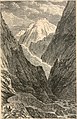
The Darial Gorge is a river gorge on the border between Russia and Georgia. It is at the east base of Mount Kazbek, south of present-day Vladikavkaz. The gorge was carved by the river Terek, and is approximately 13 kilometres (8.1 mi) long. The steep granite walls of the gorge can be as much as 1,800 metres (5,900 ft) tall in some places. The Georgian Military Road runs through the gorge.

<span class="mw-page-title-main">Derbent</span> City in the Republic of Dagestan, Russia

Derbent, formerly romanized as Derbend, is a city in Dagestan, Russia, located on the Caspian Sea. It is the southernmost city in Russia, and it is the second-most important city of Dagestan. Derbent occupies the narrow gateway between the Caspian Sea and the Caucasus Mountains connecting the Eurasian Steppe to the north and the Iranian Plateau to the south; covering an area of 69.63 square kilometres (26.88 sq mi), with a population of roughly 120,000 residents.

<span class="mw-page-title-main">Persis</span> Region in southwestern Iran

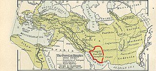
Persis, also called Persia proper, is the Fars region, located to the southwest of modern-day Iran, now a province. The Persians are thought to have initially migrated either from Central Asia or, more probably, from the north through the Caucasus. They would then have migrated to the current region of Persis in the early 1st millennium BC. The country name Persia was derived directly from the Old Persian Parsa.

<span class="mw-page-title-main">Great Wall of Gorgan</span> Ancient defensive wall in Iran

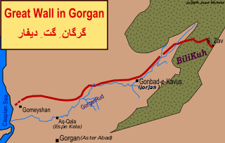
The Great Wall of Gorgan is a Sasanian-era defense system located near modern Gorgan in the Golestān Province of northeastern Iran, at the southeastern corner of the Caspian Sea. The western, Caspian Sea, end of the wall is near the remains of the fort at: 37.13981°N 54.1788733°E; the eastern end of the wall, near the town of Pishkamar, is near the remains of the fort at: 37.5206739°N 55.5770498°E. The title coordinate is for the location of the remains of a fort midway along the wall.

<span class="mw-page-title-main">Gates of Alexander</span> Mountain passes linked with Alexander the Great

The Gates of Alexander, also known as the Caspian Gates, are one of several mountain passes in eastern Anatolia, the Caucasus, and Persia separating the Greco-Roman world from the Persian world. They are often imagined as an actual fortification, or as a symbolic boundary separating the civilized from the uncivilized world. The original Gates of Alexander were just south of the Caspian Sea, at Rhagae, where Alexander crossed while pursuing Darius III. The name was transferred to passes through the Caucasus, on the other side of the Caspian, by the more fanciful historians of Alexander.

<span class="mw-page-title-main">Sakastan (Sasanian province)</span> Province of the Sasanian Empire

Sakastan was a Sasanian province in Late Antiquity, that lay within the kust of Nemroz. The province bordered Kirman in the west, Spahan in the north west, Kushanshahr in the north east, and Turan in the south east. The governor of the province held the title of marzban. The governor also held the title of "Sakanshah" until the title was abolished in ca. 459/60.

<span class="mw-page-title-main">Mazun (Sasanian province)</span> Province of the Sasanian Empire

Mazun was a Sasanian province in Late Antiquity, which corresponded to modern-day Bahrain, Qatar, United Arab Emirates, and the northern half of Oman. The province served as a Sasanian outpost and played an important role in the Sasanian efforts to gain control over the Indian Ocean trade, and to establish their dominance in the wealthy regions of Hadramaut and Yemen.

<span class="mw-page-title-main">Sasanian Empire</span> Last pre-Islamic Iranian empire (224–651 AD)

The SasanianEmpire or Sassanid Empire, also known as the Second Persian Empire or Neo-Persian Empire, was the last Iranian empire before the early Muslim conquests of the 7th to 8th centuries. Named after the House of Sasan, it endured for over four centuries, from 224 to 651, making it the second longest-lived Persian imperial dynasty after the Arsacids of the Parthian Empire.

<span class="mw-page-title-main">Caucasian Albania (Sasanian province)</span> Satrapy of the Sassanid Empire

Caucasian Albania was a kingdom in the Caucasus, which was under the suzerainty of the Sasanian Empire from 252 to 636.

<span class="mw-page-title-main">Shapur II's Arab campaign</span>

The Shapur II's Arab campaign took place in 325, against numerous Arab tribes, due to the Arab incursions into the Sasanian Empire. Shapur II decisively defeated all the Arab tribes during his campaign, and became known as Dhū al-Aktāf to the Arabs, meaning “he who pierces shoulders”.

<span class="mw-page-title-main">Sasanian Iberia</span> Period of Sasanian suzerainty over Iberia

Sasanian Iberia was the period the Kingdom of Iberia was under the suzerainty of the Sasanian Empire. The period includes when it was ruled by Marzbans (governors) appointed by the Sasanid Iranian king, and later through the Principality of Iberia.

<span class="mw-page-title-main">Kirman (Sasanian province)</span> Province of the Sasanian Empire

Kirman was a Sasanian province in Late Antiquity, which almost corresponded to the present-day province of Kerman. The province bordered Pars in the west, Abarshahr and Sakastan in the northeast, Paradan in the east, Spahan in the north, and Mazun in the south. The capital of the province was Shiragan.

<span class="mw-page-title-main">Fortifications of Derbent</span> UNESCO World Heritage Site

The Fortifications of Derbent (Darband) are one of the fortified defense lines, some of which date to the times as early as those built by the Persian Sasanian Empire to protect the eastern passage of the Caucasus Mountains against the attacks of the nomadic peoples of the Pontic–Caspian steppe. With the first parts built in the 6th century during the reign of Persian emperor Khosrow I and maintained by various later Arab, Turkish and Persian regimes, the fortifications comprise three distinct elements: the citadel of Naryn-Kala at Derbent, the twin long walls connecting it with the Caspian Sea in the east, and the "mountain wall" of Dagh-Bary, running from Derbent to the Caucasus foothills in the west. The immense wall, with a height of up to twenty meters and a thickness of about 10 feet, stretched for forty kilometers between the Caspian Sea and the Caucasus Mountains, thirty north-looking towers stretched for forty kilometers between the Caspian Sea and the Caucasus Mountains, effectively blocking the passage across the Caucasus. The fortification complex was made a UNESCO World Heritage Site in 2003.

In the history of Azerbaijan, the Early Middle Ages lasted from the 3rd to the 11th century. This period in the territories of today's Azerbaijan Republic began with the incorporation of these territories into the Sasanian Persian Empire in the 3rd century AD. Feudalism took shape in Azerbaijan in the Early Middle Ages. The territories of Caucasian Albania became an arena of wars between the Byzantine Empire and the Sassanid Empire. After the Sassanid Empire was felled by the Arab Caliphate, Albania also weakened and was overthrown in 705 AD by the Abbasid Caliphate under the name of Arran. As the control of the Arab Caliphate over the Caucasus region weakened, independent states began to emerge in the territory of Azerbaijan.

References

  1. 1 2 3 "BYZANTINE-IRANIAN RELATIONS – Encyclopaedia Iranica". www.iranicaonline.org.
  2. 1 2 3 "ARCHITECTURE iii. Sasanian Period – Encyclopaedia Iranica". www.iranicaonline.org.
  3. Farrokh, Kaveh (2012). Sassanian Elite Cavalry AD 224–642. Bloomsbury Publishing. p. 41. ISBN   978-1-78200-848-4.
  4. 1 2 3 Howard-Johnston, James (2012). "The Late Sasanian Army". Late Antiquity: Eastern Perspectives: 87–127.
  5. Curtis, Vesta Sarkhosh; Stewart, Sarah (2008). The Sasanian Era. I.B. Tauris. p. 124. ISBN   978-1-84511-690-3.
  6. Frye (1993), 139
  7. Fisher, Greg (2011-04-14). Between Empires: Arabs, Romans, and Sasanians in Late Antiquity. ISBN   9780199599271.
  8. Frye (1993), 139; Levi (1994), 192
  9. "ARBĀYISTĀN – Encyclopaedia Iranica". www.iranicaonline.org.
  10. 1 2 Ward, Steven R. (2014). Immortal: A Military History of Iran and Its Armed Forces. Washington: Georgetown University Press. p. 31. ISBN   9781626160651.
  11. 1 2 3 4 Touraj Daryaee, "If these Walls Could Speak: The Barrier of Alexander, Wall of Darband and Other Defensive Moats", in Borders: Itineraries on the Edges of Iran, ed. S. Pello, Venice, 2016.
  12. "Šahrestānīhā ī Ērānšah" (PDF). www.sasanika.org.
  13. "QADESIYA, BATTLE OF – Encyclopaedia Iranica". www.iranicaonline.org.
  14. Spring, Peter (2015). Great Walls and Linear Barriers. Pen and Sword. p. 198. ISBN   9781473854048.
  15. Sijpesteijn, Petra; Schubert, Alexander T. (2014). Documents and the History of the Early Islamic World. BRILL. pp. 35–37. ISBN   9789004284340.
  16. 1 2 "APZUT KAWĀT WALL – Encyclopaedia Iranica". www.iranicaonline.org.
  17. 1 2 3 4 5 Kettenhofen, Erich (15 December 1994). "DARBAND – Encyclopaedia Iranica". www.iranicaonline.org. Retrieved 22 June 2017. Available in print: Vol. VII, Fasc. 1, pp. 13-19
  18. Magomedov, Rabadan; Murtazali, Gadjiev (2006). "The Gilgilchay Long Defensive Wall: New Investigations". Ancient East and West. 5 (1, 2): 149. Retrieved 9 April 2022.
  19. "The Caspian Shore Defensive Constructions". UNESCO. 24 October 2001.
  20. Res Gestae Divi Saporis
  21. Ehsan Yarshater. The Cambridge history of Iran, Volume 1. Cambridge University Press, 1983. ISBN   0-521-20092-X, 9780521200929, p. 141
  22. Farrokh, Kaveh (2012). Sassanian Elite Cavalry AD 224–642. Bloomsbury Publishing. ISBN   978-1-78200-848-4.
  23. Sauer, E, Nokandeh, J, Omrani Rekavadi, H, Wilkinson, T, Abbasi, GA, Schwenninger, J-L, Mahmoudi, M, Parker, D, Fattahi, M, Usher-Wilson, LS, Ershadi, M, Ratcliffe, J & Gale, R 2006, "Linear Barriers of Northern Iran: The Great Wall of Gorgan and the Wall of Tammishe", Journal of the British Institute of Persian Studies, vol 44, pp. 121-173.
  24. Kiani, M. Y. "Gorgan, iv. Archeology". Encyclopaedia Iranica (online edition). New York. Retrieved 22 November 2016.
  25. Omrani Rekavandi, H., Sauer, E., Wilkinson, T. & Nokandeh, J. (2008), The enigma of the red snake: revealing one of the world’s greatest frontier walls, Current World Archaeology, No. 27, February/March 2008, pp. 12-22.PDF 5.3 MB.
  26. "The Enigma of the Red Snake (Archaeology.co.uk)". Archived from the original on March 11, 2009.
  27. 1 2 Ball, Warwick (2016). Rome in the East: The Transformation of an Empire. Routledge. p. 365. ISBN   9781317296355.
  28. 1 2 "FORTIFICATIONS – Encyclopaedia Iranica". www.iranicaonline.org.
  29. Barthold, Vasilii Vladimirovich (2014). An Historical Geography of Iran. Princeton University Press. p. 238, footnote 49. ISBN   9781400853229.
  30. 1 2 Alibaigi, Sajjad (2019). "The Gawri Wall: a possible Partho-Sasanian structure in the western foothills of the Zagros Mountains". Antiquity. 93 (370). doi: 10.15184/aqy.2019.97 . ISSN   0003-598X.
  31. Jarus, Owen (5 November 2019). "Ancient 70-Mile-Long Wall Found in Western Iran. But Who Built It?". livescience.com.

Further reading