Seaton Carew Lighthouse

Last updated

Seaton Carew lighthouse
Hartlepool Marina - geograph.org.uk - 1260691.jpg
The surviving stone column of Seaton High Light, re-erected at Hartlepool Marina
Seaton Carew Lighthouse
Location Hartlepool, County Durham, England
Coordinates 54°41′30″N1°12′08″W / 54.691531°N 1.202151°W / 54.691531; -1.202151 Coordinates: 54°41′30″N1°12′08″W / 54.691531°N 1.202151°W / 54.691531; -1.202151
Tower
Constructed1838
Constructionashlar sandstone tower
Heightplimsol 19 metres (62 ft)
Shapecylindrical tower with lantern removed
Markingsunpainted tower
Operator Tees Navigation Company (1892)  OOjs UI icon edit-ltr-progressive.svg
HeritageHigh light: Grade II listed building
Light
Deactivated1892
Characteristic high light: F W (not in use)
low light: F R (not in use)

The Seaton Carew lighthouses were a pair of leading light towers built in Seaton Carew to guide ships into the River Tees. The low light was demolished over a century ago and what remained of the high light has been rebuilt in Hartlepool Marina. [1]

Contents

Under increasing commercial pressure from the docks at West Hartlepool the Tees Navigation Company decided to improve access to the River Tees by providing a pair of leading lighthouses (navigation light towers) on the coast at Seaton Carew. These were not the first lighthouses in Seaton Carew as there is evidence of an earlier lighthouse in the 15th century. [2]

Seaton Carew Low Light

The Low Light was on what is now Coronation Drive on the sea front at the junction with Lawson Road. [3] The Low Light was a 70 feet (21 m) tall hexagonal tower with the base at a height of 34 feet (10 m) above mean high tide [4] and exhibited a fixed red light. [3] [5] The Hartlepool steel works of South Durham Steel and Iron Company was built to the north of Seaton Carew low light. In a Board of Trade report into the grounding of the Vine in January 1877 off the mouth of the Tees it was claimed that the glow from the furnaces of the nearby steel plant may have been mistaken for the red low light. [6]

Seaton Carew High Light

The High Light and cottages were 1,189 yards (1,087 m) inland to the west at the end of Windermere Road in what is now the Longhill Industrial Estate in Hartlepool north of Tees Bay Retail Park. [3] The High Light was a 70 feet (21 m) tall Tuscan column of ashlar sandstone built in 1838 [7] with the base at a height of 89 feet (27 m) above mean high tide. [4] The High Light contained a newel helical stair lit by slit windows between the masonry blocks. [7] The High Light also known as the Longhill Lighthouse, [8] exhibited a fixed white light. [3] [5]

Deactivation and relocation

Seaton Tower, Hartlepool Marina 2009.06.16.163652 Marina Hartlepool GB.jpg
Seaton Tower, Hartlepool Marina

In 1884 a new lighthouse was built on the breakwater at the newly constructed South Gare [9] on the south bank at the mouth of the River Tees. Both light systems were used until 1892 when use of the light towers at Seaton Carew and Hartlepool was discontinued by the Tees Conservancy Commissioners. [10] The low light was probably demolished a decade later in 1902 to make way for a coastal tramway and road from Hartlepool. [11] The prospect of this demolition may have prompted local artist Thomas Grainger to create a painting of the lighthouse before it disappeared. [12]

By 1985 although the High Light tower was disused and dilapidated and had lost its gallery, it was given grade II listed building status. [7] In 1995 the tower now known as Seaton Tower, was moved by the Teesside Development Corporation to the recently regenerated Hartlepool Marina at Jackson's Landing to become a focal point, and in 1997 it was dedicated as a memorial to those who have lost their lives at sea. [13]

See also

Related Research Articles

<span class="mw-page-title-main">River Tees</span> East coast river of Northern England

The River Tees, in Northern England, rises on the eastern slope of Cross Fell in the North Pennines and flows eastwards for 85 miles (137 km) to reach the North Sea between Hartlepool and Redcar near Middlesbrough. The modern day history of the river has been tied with the industries on Teesside in its lower reaches, where it has provided the means of import and export of goods to and from the North East England. The need for water further downstream also meant that reservoirs were built in the extreme upper reaches, such as Cow Green.

<span class="mw-page-title-main">Hartlepool</span> Town in County Durham, England

Hartlepool is a seaside and port town in County Durham, England. It is governed by a unitary authority borough named after the town which also governs the civil parishes of Greatham, Hart, Dalton Piercy and Elwick. The borough is part of the devolved Tees Valley area. With an estimated population of 90,123, it is the second-largest settlement in County Durham.

<span class="mw-page-title-main">Seaton Carew</span> Seaside resort in County Durham, England

Seaton Carew is a seaside resort in the Borough of Hartlepool in County Durham, England. It had an estimated population of 6,018. The area is named after a Norman French family called Carou who owned lands in the area and settled there, while 'Seaton' means farmstead or settlement by the sea.

<span class="mw-page-title-main">Hartlepool nuclear power station</span> Nuclear power station in Hartlepool, England

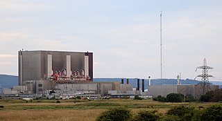
Hartlepool nuclear power station is a nuclear power station situated on the northern bank of the mouth of the River Tees, 2.5 mi south of Hartlepool in County Durham, North East England. The station has a net electrical output of 1,185 megawatts, which is 2% of Great Britain's peak electricity demand of 60 GW. Electricity is produced through the use of two advanced gas-cooled reactors (AGR). Hartlepool was only the third nuclear power station in the United Kingdom to use AGR technology. It was also the first nuclear power station to be built close to a major urban area.

<span class="mw-page-title-main">Ambrose Light</span> Former light station in the Lower New York Bay, USA

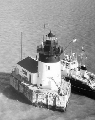
Ambrose Light, often called Ambrose Tower, was the light station at the convergence of several major shipping lanes in Lower New York Bay, including Ambrose Channel, the primary passage for ships entering and departing the Port of New York and New Jersey.

<span class="mw-page-title-main">Lake Memphremagog</span> Lake on the border of Vermont and Quebec

Lake Memphremagog is a fresh water glacial lake located between Newport, Vermont, United States and Magog, Quebec, Canada. The lake spans both Quebec and Vermont, but is mostly in Quebec. Most of the watershed that feeds the lake is located in Vermont, and is a source for accumulated phosphorus, sediments, and other pollutants. Cleanup efforts since the late 1980s have improved the water quality. The lake furnishes potable water for 200,000 people.

<span class="mw-page-title-main">Algoma Light</span> Lighthouse

The Algoma Light or Algoma Pierhead Light is a lighthouse located near Algoma in Kewaunee County, Wisconsin.

<span class="mw-page-title-main">Manitou Island Light Station</span> Lighthouse in Michigan, United States

The Manitou Island Light Station is a lighthouse located on Manitou Island, off the tip of Michigan's Keweenaw Peninsula in Lake Superior. It was listed on the National Register of Historic Places in 1984.

<span class="mw-page-title-main">Milwaukee Breakwater Light</span> Lighthouse

The Milwaukee Breakwater lighthouse was built in 1926 in the harbor of Milwaukee in Milwaukee County, Wisconsin to mark the entrance to the harbor. One of the last fully enclosed breakwater lighthouses in the Great Lakes, the structure was placed on the National Register of Historic Places in 2011.

<span class="mw-page-title-main">Rock of Ages Light</span> Lighthouse in Michigan, United States

The Rock of Ages Light is a U.S. Coast Guard lighthouse on a small rock outcropping approximately 2.25 miles (3.62 km) west of Washington Island and 3.5 miles (5.6 km) west of Isle Royale, in Eagle Harbor Township, Keweenaw County, Michigan. It is an active aid to navigation.

<span class="mw-page-title-main">Able UK</span> British industrial services company

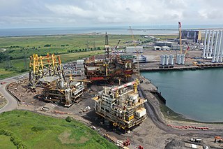
Able UK is a British industrial services company specialising in decommissioning of ships and offshore installations.

<span class="mw-page-title-main">Detroit River Light</span> Lighthouse in Michigan, United States

The Detroit River Light, also known as Bar Point Shoal Light, was first established as a lightship in 1875. The current sparkplug lighthouse was built in 1885. It sits in Lake Erie, south of the mouth of the Detroit River, 1.75 nautical miles from land and about 20 nautical miles from the Ambassador Bridge in the Detroit River. It is about 0.4 nautical miles from the border with Canada, and just under 24 nautical miles from Put-in-Bay, Ohio. Its original 4th order Fresnel lens is on loan to the Michigan Maritime Museum.

<span class="mw-page-title-main">Grand Island Harbor Rear Range Light</span> Lighthouse in Michigan, United States

The Grand Island Harbor Rear Range Light is a lighthouse located off M-28 in Munising Township, Michigan. It is also known as the Bay Furnace Rear Range Light, Christmas Rear Range Light, or End of the Road Light. The corresponding front range light was replaced in 1968; the rear range light was listed on the National Register of Historic Places in 1990. It is no longer an active aid to navigation.

<span class="mw-page-title-main">Burnham-on-Sea Low Lighthouse</span> Lighthouse

The Low Lighthouse is one of three historic lighthouses in Burnham-on-Sea, Somerset, England, and the only one of the three which is still active. It is a Grade II listed building and stands on the foreshore. First lit in 1832, the Low Lighthouse operated in conjunction with the (onshore) High Lighthouse for 137 years. Then, in 1969 the Low Lighthouse was deactivated; but later, in 1993, the Low Lighthouse was re-established and the High Lighthouse was instead decommissioned).

<span class="mw-page-title-main">South Gare</span> Human settlement in England

South Gare is an area of reclaimed land and breakwater on the southern side of the mouth of the River Tees in Redcar and Cleveland, England. It is accessed by taking the South Gare Road from Fisherman's Crossing at the western end of Tod Point Road in Warrenby.

<span class="mw-page-title-main">South Gare Lighthouse</span> Lighthouse

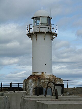
South Gare Lighthouse was built in 1884 at the end of the breakwater at South Gare north west of Redcar in North Yorkshire and in north eastern England.

<span class="mw-page-title-main">Humboldt Bay Life-Saving Station</span> United States historic place

The Humboldt Bay Life-Saving Station was originally built in November 1878 on the north side of the entrance to Humboldt Bay in northern California, United States near Eureka, adjacent to the site of the first Humboldt Harbor Light (1856–1892). Rebuilt in 1936 with marine railways to launch rescue surfboats, the historic facility was placed on the National Register of Historic Places on October 30, 1979. The station continues to function as an important asset of the United States Coast Guard in the Coast Guard Group/Air Station Humboldt Bay.

<span class="mw-page-title-main">Seaton Carew Golf Club</span>

Seaton Carew Golf Club has held golf games since 1874, making it the tenth oldest golf club in England. The club is based in Seaton Carew, near Hartlepool on the North Sea coast, north of the River Tees in North East England. When it was first established it was the only golf club in the English counties of Yorkshire and Durham, hence its original name Durham & Yorkshire Golf Club; the club's crest and badge retain the emblems of both the Archbishop of Durham and The Archbishop of York.

<span class="mw-page-title-main">Heugh Lighthouse</span> Lighthouse in County Durham, England

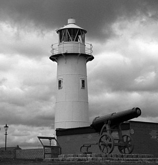
The Heugh Lighthouse is a navigation light on The Headland in Hartlepool, in north-east England. The current lighthouse dates from 1927; it is owned and operated by PD Ports. It is claimed that its early-Victorian predecessor was the first lighthouse in the world reliably lit by gas.

<span class="mw-page-title-main">Stranton</span> Area of Hartlepool, England

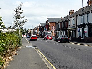
Stranton is an area of south Hartlepool in the borough of Hartlepool, County Durham, England. It is a former village and parish.

References

  1. Rowlett, Russ. "Lighthouses of Northeastern England". The Lighthouse Directory. University of North Carolina at Chapel Hill . Retrieved 6 May 2016.
  2. "Access to Archives". The National Archives. 2009. Retrieved 28 July 2010.[ dead link ]
  3. 1 2 3 4 "Seaton Carew Lighthouse". Lighthouse Compendium. Archived from the original on 24 April 2012. Retrieved 9 December 2011.
  4. 1 2 "Bartholomew Gazetteer entry for Seaton Carew". Vision of Britain. Archived from the original on 3 March 2016. Retrieved 21 September 2009.
  5. 1 2 "Vine (S.S.)" (PDF). Portcities Southampton. Archived (PDF) from the original on 2 June 2012. Retrieved 13 September 2009.
  6. UK Board of Trade (1877). "Wreck Report for 'Vine'" (PDF). PortCities Southampton. Archived from the original on 10 February 2015. Retrieved 10 February 2015.
  7. 1 2 3 "Seaton High Light in Grounds of Vulcan Materials United Kingdom Limited". British Listed Buildings. Archived from the original on 4 October 2013. Retrieved 29 July 2010.
  8. "Place:Hartlepool Registration District, 1891 Census Street Index J-L". Your Archives. 2010. Archived from the original on 21 June 2011. Retrieved 21 April 2011.
  9. "South Gare Lighthouse Hydrogen Fuel Cell Beams Brightly". New England Lighthouse Treasures. 2007. Archived from the original on 8 May 2009. Retrieved 27 December 2009.
  10. "The London Gazette, 19 July 1892" (PDF). The London Gazette. Retrieved 15 January 2012.[ dead link ]
  11. Gould, Peter. "West Hartlepool Corporation Transport: 1912–1967". Local Transport Histories. Archived from the original on 21 June 2008. Retrieved 7 September 2013.
  12. "Can anyone put Paul in the picture?". Hartlepool Mail. 31 January 2008. Retrieved 27 August 2009.;[ dead link ] "Seaton Carew Lighthouse". Thumbrella – Words to a Void. 3 October 2007. Archived from the original on 16 November 2007. Retrieved 11 December 2008.
  13. "Memorial: Harbour Light 1914–18". North East War Memorials Project. 2006. Archived from the original on 4 October 2013. Retrieved 15 January 2012.

Seaton Carew Low Light historic images: