Related Research Articles

A geographic information system (GIS) consists of integrated computer hardware and software that store, manage, analyze, edit, output, and visualize geographic data. Much of this often happens within a spatial database, however, this is not essential to meet the definition of a GIS. In a broader sense, one may consider such a system also to include human users and support staff, procedures and workflows, the body of knowledge of relevant concepts and methods, and institutional organizations.

The Semantic Web, sometimes known as Web 3.0, is an extension of the World Wide Web through standards set by the World Wide Web Consortium (W3C). The goal of the Semantic Web is to make Internet data machine-readable.
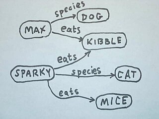
In information science, an ontology encompasses a representation, formal naming, and definitions of the categories, properties, and relations between the concepts, data, or entities that pertain to one, many, or all domains of discourse. More simply, an ontology is a way of showing the properties of a subject area and how they are related, by defining a set of terms and relational expressions that represent the entities in that subject area. The field which studies ontologies so conceived is sometimes referred to as applied ontology.
The Web Ontology Language (OWL) is a family of knowledge representation languages for authoring ontologies. Ontologies are a formal way to describe taxonomies and classification networks, essentially defining the structure of knowledge for various domains: the nouns representing classes of objects and the verbs representing relations between the objects.
Semantic similarity is a metric defined over a set of documents or terms, where the idea of distance between items is based on the likeness of their meaning or semantic content as opposed to lexicographical similarity. These are mathematical tools used to estimate the strength of the semantic relationship between units of language, concepts or instances, through a numerical description obtained according to the comparison of information supporting their meaning or describing their nature. The term semantic similarity is often confused with semantic relatedness. Semantic relatedness includes any relation between two terms, while semantic similarity only includes "is a" relations. For example, "car" is similar to "bus", but is also related to "road" and "driving".
Sensor web is a type of sensor network that heavily utilizes the World Wide Web and is especially suited for environmental monitoring. OGC's Sensor Web Enablement (SWE) framework defines a suite of web service interfaces and communication protocols abstracting from the heterogeneity of sensor (network) communication.
The ultimate goal of semantic technology is to help machines understand data. To enable the encoding of semantics with the data, well-known technologies are RDF and OWL. These technologies formally represent the meaning involved in information. For example, ontology can describe concepts, relationships between things, and categories of things. These embedded semantics with the data offer significant advantages such as reasoning over data and dealing with heterogeneous data sources.
OWL-S is an ontology built on top of Web Ontology Language (OWL) by the DARPA DAML program. It replaces the former DAML-S ontology. "OWL-S is an ontology, within the OWL-based framework of the Semantic Web, for describing Semantic Web Services. It will enable users and software agents to automatically discover, invoke, compose, and monitor Web resources offering services, under specified constraints."

In computing, linked data is structured data which is interlinked with other data so it becomes more useful through semantic queries. It builds upon standard Web technologies such as HTTP, RDF and URIs, but rather than using them to serve web pages only for human readers, it extends them to share information in a way that can be read automatically by computers. Part of the vision of linked data is for the Internet to become a global database.
The terms schema matching and mapping are often used interchangeably for a database process. For this article, we differentiate the two as follows: schema matching is the process of identifying that two objects are semantically related while mapping refers to the transformations between the objects. For example, in the two schemas DB1.Student and DB2.Grad-Student ; possible matches would be: DB1.Student ≈ DB2.Grad-Student; DB1.SSN = DB2.ID etc. and possible transformations or mappings would be: DB1.Marks to DB2.Grades.
The Semantic Web Stack, also known as Semantic Web Cake or Semantic Web Layer Cake, illustrates the architecture of the Semantic Web.
Amit Sheth is a computer scientist at University of South Carolina in Columbia, South Carolina. He is the founding Director of the Artificial Intelligence Institute, and a Professor of Computer Science and Engineering. From 2007 to June 2019, he was the Lexis Nexis Ohio Eminent Scholar, director of the Ohio Center of Excellence in Knowledge-enabled Computing, and a Professor of Computer Science at Wright State University. Sheth's work has been cited by over 48,800 publications. He has an h-index of 106, which puts him among the top 100 computer scientists with the highest h-index. Prior to founding the Kno.e.sis Center, he served as the director of the Large Scale Distributed Information Systems Lab at the University of Georgia in Athens, Georgia.
Observations and Measurements (O&M) is an international standard which defines a conceptual schema encoding for observations, and for features involved in sampling when making observations. While the O&M standard was developed in the context of geographic information systems, the model is derived from generic patterns proposed by Fowler and Odell, and is not limited to geospatial information. O&M is one of the core standards in the OGC Sensor Web Enablement suite, providing the response model for Sensor Observation Service (SOS).
GeoSPARQL is a standard for representation and querying of geospatial linked data for the Semantic Web from the Open Geospatial Consortium (OGC). The definition of a small ontology based on well-understood OGC standards is intended to provide a standardized exchange basis for geospatial RDF data which can support both qualitative and quantitative spatial reasoning and querying with the SPARQL database query language.
Semantic heterogeneity is when database schema or datasets for the same domain are developed by independent parties, resulting in differences in meaning and interpretation of data values. Beyond structured data, the problem of semantic heterogeneity is compounded due to the flexibility of semi-structured data and various tagging methods applied to documents or unstructured data. Semantic heterogeneity is one of the more important sources of differences in heterogeneous datasets.
Semantic queries allow for queries and analytics of associative and contextual nature. Semantic queries enable the retrieval of both explicitly and implicitly derived information based on syntactic, semantic and structural information contained in data. They are designed to deliver precise results or to answer more fuzzy and wide open questions through pattern matching and digital reasoning.
Privacy engineering is an emerging field of engineering which aims to provide methodologies, tools, and techniques to ensure systems provide acceptable levels of privacy.

Pascal Hitzler is a German American computer scientist specializing in Semantic Web and Artificial Intelligence. He is endowed Lloyd T. Smith Creativity in Engineering Chair and Director of the Center for Artificial Intelligence and Data Science at Kansas State University, and the founding Editor-in-Chief of the Semantic Web journal and the IOS Press book series Studies on the Semantic Web.
Terry R. Payne is a computer scientist and artificial intelligence researcher at the University of Liverpool. He works on the use of ontologies by Software Agents within decentralised environments. He is best known for his work on Semantic Web Services and in particular for his work on OWL-S.

Web GIS, or Web Geographic Information Systems, are GIS that employ the World Wide Web to facilitate the storage, visualization, analysis, and distribution of spatial information over the Internet. The World Wide Web, or the Web, is an information system that uses the internet to host, share, and distribute documents, images, and other data. Web GIS involves using the World Wide Web to facilitate GIS tasks traditionally done on a desktop computer, as well as enabling the sharing of maps and spatial data. While Web GIS and Internet GIS are sometimes used interchangeably, they are different concepts. Web GIS is a subset of Internet GIS, which is itself a subset of distributed GIS, which itself is a subset of broader Geographic information system. The most common application of Web GIS is Web mapping, so much so that the two terms are often used interchangeably in much the same way as Digital mapping and GIS. However, Web GIS and web mapping are distinct concepts, with web mapping not necessarily requiring a Web GIS.
References
- ↑ "Sensor Web Enablement DWG". Archived from the original on 2008-07-20. Retrieved 2009-03-09.
- ↑ Bröring, Arne; Echterhoff, Johannes; Jirka, Simon; Simonis, Ingo; Everding, Thomas; Stasch, Christoph; Liang, Steve; Lemmens, Rob (2011). "New Generation Sensor Web Enablement". Sensors. 11 (3): 2652–2699. Bibcode:2011Senso..11.2652B. doi: 10.3390/s110302652 . PMC 3231615 . PMID 22163760.
- ↑ Sheth, Amit; Henson, Cory; Sahoo, Satya S. (2008). "Semantic Sensor Web". IEEE Internet Computing. 12 (4): 78–83. doi:10.1109/MIC.2008.87. S2CID 1975770.
- ↑ Semantic Sensor Network Ontology
- ↑ SSN Applications
- ↑ Coronato, A.; Pietro, G.; Esposito, M. (2006). "A Semantic Context Service for Smart Offices". 2006 International Conference on Hybrid Information Technology. pp. 391–399. doi:10.1109/ICHIT.2006.253638. ISBN 0-7695-2674-8.
- ↑ Taylor, Kerry; Griffith, Colin; Lefort, Laurent; Gaire, Raj; Compton, Michael; Wark, Tim; Lamb, David; Falzon, Greg; Trotter, Mark (2013). "Farming the Web of Things". IEEE Intelligent Systems. 28 (6): 12–19. doi:10.1109/MIS.2013.102. hdl: 1885/66582 . S2CID 14545083.
- ↑ Sheth, Amit; Henson, Cory; Sahoo, Satya S. (2008). "Semantic Sensor Web". IEEE Internet Computing. 12 (4): 78–83. doi:10.1109/MIC.2008.87. S2CID 1975770.
- ↑ Zarri, Gian Piero; Sabri, Lyazid; Chibani, Abdelghani; Amirat, Yacine (2010). "Semantic-Based Industrial Engineering: Problems and Solutions". 2010 International Conference on Complex, Intelligent and Software Intensive Systems. pp. 1022–1027. doi:10.1109/CISIS.2010.94. ISBN 978-1-4244-5917-9. S2CID 17787203.
- ↑ McCreedy, Frank P.; Marks, David B. (2009). "The Naval Research Laboratory's ongoing implementation of the Open Geospatial Consortium's Catalogue Services specification". Oceans 2009. IEEE. pp. 1–7. doi:10.23919/OCEANS.2009.5422315. ISBN 978-1-4244-4960-6. S2CID 28647945.