Sestao

Last updated
Sestao
Sestao Kasko udaletxea.jpg
Town Hall
BANDERA SESTAO.jpg
Escudo de Sestao.svg
Basque Country location map.svg
Red pog.svg
Sestao
Location of Sestao within the Basque Country
Spain location map with provinces.svg
Red pog.svg
Sestao
Sestao (Spain)
Coordinates: 43°18′39″N3°0′20″W / 43.31083°N 3.00556°W / 43.31083; -3.00556 Coordinates: 43°18′39″N3°0′20″W / 43.31083°N 3.00556°W / 43.31083; -3.00556
Country Flag of Spain.svg  Spain
Autonomous community Flag of the Basque Country.svg  Basque Country
Province Biscay
Comarca Greater Bilbao
Segregatted1805
Government
   Alcalde Josu Bergara López (EAJ-PNV)
Area
  Total3.49 km2 (1.35 sq mi)
Elevation
6,762 m (22,185 ft)
Population
 (2018) [1]
  Total27,445
  Density7,900/km2 (20,000/sq mi)
Demonym sestaotarra [2]
Time zone UTC+1 (CET)
  Summer (DST) UTC+2 (CEST)
Postal code
48910
Official language(s) Basque
Website Official website

Sestao is a town and municipality of 27,296 inhabitants located in the province of Biscay, in the autonomous community of Basque Country, northern Spain. It is in the left bank of the Estuary of Bilbao and part of Bilbao's metropolitan area. [3]

Contents

Sestao was the place of the most important steel industry of Biscay, Altos Hornos de Vizcaya.

Neighbourhoods

Sestao is administratively divided into 13 neighbourhoods or wards:

Demography

Historical population
YearPop.±%
1800 340    
1850 346+1.8%
1877 4,347+1156.4%
1885 4,729+8.8%
1890 6,851+44.9%
1900 10,833+58.1%
1910 11,820+9.1%
1920 15,579+31.8%
1930 18,335+17.7%
YearPop.±%
1940 18,625+1.6%
1950 19,969+7.2%
1960 24,992+25.2%
1970 37,312+49.3%
1981 39,933+7.0%
1991 35,537−11.0%
2001 32,533−8.5%
2005 30,350−6.7%
2014 28,288−6.8%


Rehabilitation of Sestao

Sestao, an industrial area in disuse placed in the province of the Basque Country (Spain), is located in the estuary of Bilbao. It appeared due to diverse economic, social and political forces, but it was the economic strength of the iron industry that proved to be the most important. Over the last 20 years the city of Bilbao has transformed its riverbanks, pursuing urban, environmental and economic improvement. The recovery of these old industrial spaces and the relocation of port activities to the outer bay will allow the city to face its river front and start a general process of urban transformation. The spaces previously occupied by the shipyards, containers or blast furnaces, are to become promenades, parks, art galleries, new neighborhoods and areas of business of high environmental quality.

1:700.000 National scale

The industrial crisis of the 80 affected greatly Bilbao. The closure and modernization of major industries was a major impact on the whole environment of the river and, at the same time, an opportunity to recover valuable land for urban development of the city. The transformation of the city is creating an economic structure focused on services, culture and new industries. The river banks are now serving an urban strategy for environmental and economic improvement. The estuary is therefore the backbone of the area, but it is also a strong barrier that separates both margins of the river: one with a much more industrial character and another one much more residential. Sestao is the area that links all this area that will propose a real integral operation of all this area.

Ria 2000 Project.jpg

1:150:000 Regional scale

Although the area seems isolated, thanks to the station Urbinaga, is perfectly integrated in the network of Metro Bilbao, connecting Bilbao with the Right Bank and Left, offering an essential service to the future citizens of "La Punta".

1:15:000 Urban scale. Evolution of area through time

Redensification

La Punta is an abandoned edge of the town. Sestao has the highest unemployment rate in the Basque Country, due to the closure of large companies because of their restructuring; despite this fact it has no social facilities to help this portion of the population to improve. Comparing the residential areas of Sestao and Barakaldo with "La Punta", it seems necessary to densify this area and thus strengthen the bond between Barakaldo and Sestao, and the relationship with the right bank of the river.

Urban barriers

The growth of the town of Sestao is limited by the lack of developable land and severely limited by natural and artificial barriers. For this reason, it has reached a highly densified town with a network of small open spaces. Historically, The grew of the population was a consequence of the development of the industry, and not the industry a consequence of the human presence in the area. This defines the DNA of Sestao. It is a settlement that is born exclusively by the implantation of the heavy industry. Consumption and land distribution is based on the industry (now there is more floor dedicated to industrial than residential uses) and these industrial areas are located in the best situations the city. The margin facing the estuary is colonized exclusively for industry, and the least quality areas (up to sixty meters of altitude) is intended to construction of workers' housing.

Natural Processes

It is proposed that over time the vegetation in the low-lying industrial areas of the Galindo River estuary is slowly restored to a healthy state by actively cultivating the growth of plants that are naturally resistant to local soil contamination, and that improve soil and water quality through bio-remediation. Rather than a tabula rasa to be integrated into the city with a false topography, the industrial areas of Bilbao are in a new natural equilibrium condition. Working with these new natural conditions offers the possibility of an urbanism that combines urban and natural and responds to the fluctuations of the natural ecosystem of the river.

Since the appearance of the industry in 1875, the whole estuary became involved in the configuration of an industrial point of reference in the Spanish national scene of heavy industries. Meanwhile, the municipality of Sestao created the largest industrial base of the country.

Nasa, Visible Earth Project.jpg

http://visibleearth.nasa.gov

Prediction. Regeneration strategies

Network of public spaces

The city will probably develop a system of small public spaces that provide residents moments of pause, rest, interactions and connections between the different urban levels.

Connection

Connection of both margins of the river.

Facilities

Program associated with the estuary and the existing water activity (Kaiku drifters).

Viewpoints

Recovery of the convent as a viewpoint. The view shows the contrast between the industrial landscape lined by shipyard cranes and the historic mansions of the Basque bourgeoisie.

Tram

Integration of the tram connected to Bilbao and the right bank of the river.

Rehabilitation

Rehabilitation of ships in better condition to include public program to allow the language of industrial structures: from jetties, cranes, pipes, and temporary stairs to pylons.

Housing and facilities

Housing and facilities of social nature.

Notable people

Urban structure and Urban road.jpg

Sources and citations

Soriano, Federico (2007), FISURAS 14

VV.AA., Diccionario Metapolis de Arquitectura Avanzada, ACTAR, 2002

Rehabilitación de la Ría de Bilbao. PFC, VVAA. Universidad Politécnica de Madrid. 2014

VV.AA., PGOU Plan General de Organización Urbana de Sestao, 2010

VVAA, Slow Urbanism, Sestao. Europan 11, 2011

https://www.google.com/maps?q=SESTAO+BILBAO&gws_rd=ssl&um=1&ie=UTF-8&sa=X&ved=0ahUKEwi80qv7wPXPAhVLFT4KHdGcAfYQ_AUICCgB

Related Research Articles

<span class="mw-page-title-main">Bilbao</span> Municipality in Basque Country, Spain

Bilbao is a city in northern Spain, the largest city in the province of Biscay and in the Basque Country as a whole. It is also the largest city proper in northern Spain. Bilbao is the tenth largest city in Spain, with a population of 345,141 as of 2015. The Bilbao metropolitan area has 1,037,847 inhabitants, making it one of the most populous metropolitan areas in northern Spain; with a population of 875,552 the comarca of Greater Bilbao is the fifth-largest urban area in Spain. Bilbao is also the main urban area in what is defined as the Greater Basque region.

<span class="mw-page-title-main">Biscay</span> Province of Spain

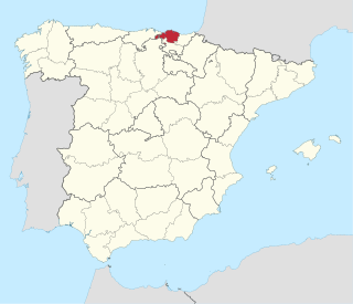
Biscay is a province of Spain and a historical territory of the Basque Country, heir of the ancient Lordship of Biscay, lying on the south shore of the eponymous bay. The capital and largest city is Bilbao.

<span class="mw-page-title-main">Euskotren Tranbia</span> Tram system in Bilbao and Vitoria-Gasteiz, Spain

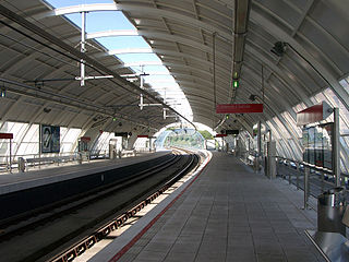
Euskotren Tranbia is the brand under which the tramway networks in the cities of Vitoria-Gasteiz and Bilbao are run. The system in Bilbao started operations in 2002, and the one in Vitoria-Gasteiz in 2008. It is one of the four commercial divisions under which Euskotren operates. The infrastructure is owned by the public entity Euskal Trenbide Sarea and tracks use 1,000 mm narrow gauge.

<span class="mw-page-title-main">Nervión</span> River in Spain

The River Nervión runs through the town of Bilbao, Spain into the Cantabrian Sea. Its lowermost course, downstream of its confluence with the Ibaizabal River, is known as the Estuary of Bilbao.

<span class="mw-page-title-main">Barakaldo</span> City in Basque Country, Spain

Barakaldo is a municipality located in the Biscay province in the Basque Country. Located on the Left Bank of the Estuary of Bilbao, the city is part of Greater Bilbao with a population as of the 2019 census at 100,881;. Barakaldo has an industrial river-port heritage and has undergone significant redevelopment with new commercial and residential areas replacing the once active industrial zones.

<span class="mw-page-title-main">Erandio</span> Municipality in Basque Country, Spain

Erandio is a town and municipality located in the province of Biscay, in the autonomous community of Basque Country, northern Spain. The name comes from euskera ARANDIO that means plum plantation or field.

<span class="mw-page-title-main">Getxo</span> Municipality in Basque Country, Spain

Getxo is a town located in the province of Biscay, in the autonomous community of the Basque Country, in Spain. It is part of Greater Bilbao, and has 77,946 inhabitants (2019). Getxo is mostly an affluent residential area, as well as being the third largest municipality of Biscay.

<span class="mw-page-title-main">Valle de Trápaga-Trapagaran</span> Municipality in Basque Country, Spain

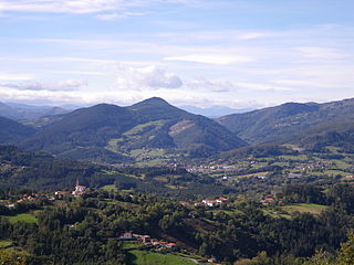
Valle de Trápaga-Trapagaran is a town and municipality located in the province of Biscay, in the autonomous community of Basque Country, northern Spain. It is located near Barakaldo, Portugalete and Ortuella. Iron ore has been mined here since Roman times and the two parts of the municipality, which are at different altitudes, are linked by a funicular railway. According to the 2019 census, it has 11,985 inhabitants.

<span class="mw-page-title-main">Left Bank (Biscay)</span>

The left bank of the Estuary of Bilbao is a part of the Greater Bilbao region, its main towns are Barakaldo, Sestao, Santurtzi and Portugalete and in addition to the iron mines, was the heart of the intense industrialisation of Biscay. Thousands of workers from all Spain came to the area during the 19th and the 20th century to work in the major shipbuilding and steel industries like Altos Hornos de Vizcaya and La Naval. Hence it was one of the birthplaces of the worker movement in Spain. The Socialist leader Indalecio Prieto and the Communist Pasionaria found their initial audiences here.

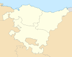
Greater Bilbao is an administrative division of the province of Biscay, in the Basque Country, Spain. It is one of the seven comarcas of Biscay and the most populated one. The capital city of Greater Bilbao is Bilbao.

<span class="mw-page-title-main">Altos Hornos de Vizcaya</span>

Altos Hornos de Vizcaya, S.A. was a Spanish metallurgy manufacturing company. It was the largest company in Spain for much of the 20th century, employing 40,000 workers at its height. The business began in 1902 in Bilbao with the merger of three iron and steel businesses: Altos Hornos de Bilbao, La Vizcaya, and La Iberia. In the 1990s, following a series of mergers, it joined with Arcelor.

The Estuary of Bilbao lies at the common mouth of the rivers Nervion, Ibaizabal and Cadagua, which drain most of Biscay and part of Alava in the Basque Country, Spain. In this instance, the Spanish word estuario is used to describe what in English would normally be called part estuary, part tidal river. The estuary becomes a tidal river which extends 16 km (9.9 mi) into the city of Bilbao, starting from the Bilbao Abra bay. It hosts the port of Bilbao throughout its length, although the Port Authority has recently restored most of the upper reaches to Bilbao and other municipalities for their urban regeneration. The port is now being transferred to the seaboard on the coast at Santurtzi and Zierbena.

<span class="mw-page-title-main">Enkarterri</span> Eskualdea / Comarca in Basque Country, Spain

Enkarterri is a comarca of the province of Biscay, in the Basque Country, Spain. It is one of the seven eskualdeak/comarcas or districts that make up the province of Biscay. Its administrative centre is Balmaseda.

<span class="mw-page-title-main">Uribe</span>

The Merindad de Uribe or Uribealdea is a historical subdivision of Biscay, Basque Country, Spain. It contained most of the municipalities now within the comarca of Greater Bilbao in the Bilbao metropolitan area. The parts of Uribe which now fall under Greater Bilbao are:

<span class="mw-page-title-main">Deusto</span> District in Basque Country, Spain

Deusto, also known as Deustu in Basque and formerly known as San Pedro de Deusto, is one of the eight districts of Bilbao, (Spain). It is located on the right side of the Bilbao estuary, in the northwestern part of the city and bordering the estuary itself on the south and the southern hillside of Mount Artxanda and Mount Bandera on the north. Deusto was originally an elizate and also a municipality until 1925 when it was completely annexed by Bilbao in order to expand the free land available to the city. Deusto is known as the university district of the city as it is home to the University of Deusto and the Faculty of Economics and Business of the University of the Basque Country.

<span class="mw-page-title-main">Abando</span> District in Basque Country, Spain

Abando, formerly known as San Vicente de Abando, is one of the eight districts of Bilbao, Basque Country (Spain). It covers most of the city's centre, located on the left bank of the estuary of Bilbao. It is the only district of Bilbao with all of its land completely urbanised. Abando was originally an elizate and also a municipality until 1876, when part of it was annexed to Bilbao, the rest of the elizate's municipal land was integrated into Bilbao in 1890. In 2016 the population was 50,903. Abando is the wealthiest district in Bilbao, with personal and family incomes being well above the citywide average.

<span class="mw-page-title-main">Basque Country (autonomous community)</span> Autonomous community of Spain

The Basque Country, also called Basque Autonomous Community, is an autonomous community of Spain. It includes the provinces of Álava, Biscay, and Gipuzkoa, located in the north of the Iberian Peninsula, bordering on the autonomous communities of Cantabria, Castile and León, La Rioja, and Navarre, and the French region of Nouvelle-Aquitaine.

<span class="mw-page-title-main">Line 2 (Bilbao metro)</span> Metro line in Biscay, Basque Country, Spain

Line 2 of the Bilbao metro is a rapid transit line in Biscay, Basque Country, Spain. It runs from Basauri to Kabiezes. Its route covers the municipalities of Basauri and Etxebarri, the city of Bilbao and the left bank of the Nervión river. The line has 25 stations.

<span class="mw-page-title-main">Bilbao metropolitan area</span>

The Bilbao Metropolitan Area is the metropolitan area or continuous urban area based around the city of Bilbao, in the Basque Country, Spain. It comprises the city of Bilbao, the 25 municipalities that make the comarca of Greater Bilbao plus ten other surrounding municipalities, all of them in the province of Biscay.

<span class="mw-page-title-main">Comarcas of the Basque Country</span>

The autonomous Community of the Basque Country within Spain contains several comarcas or eskualdeak in the Basque language, referring to local districts, grouped into its three long-established provinces.

References

  1. Municipal Register of Spain 2018. National Statistics Institute.
  2. Euskaltzaindia. "Euskal Onomastikaren Datutegia (EODA): Sestao" (in Basque). Euskaltzaindia. Retrieved 3 July 2010.
  3. Ainhoa Arozamena Ayala. "Auñamendi Encyclopedia: Sestao" (in Spanish). Eusko Ikaskuntza . Retrieved 3 July 2010.