Seymour Island

Last updated

Seymour Island
Antarctic Peninsula location map.svg
Red pog.svg
Seymour Island
Antarctic Peninsula
Geography
Location Antarctica
Coordinates 64°14′S56°37′W / 64.233°S 56.617°W / -64.233; -56.617
Archipelago James Ross Island group
Administration
None
Demographics
Population0
[1]
Geologic map of Seymour Island, Antarctica Geologic map of Seymour Island, Antarctica.png
Geologic map of Seymour Island, Antarctica

Seymour Island or Marambio Island, is an island in the chain of 16 major islands around the tip of the Graham Land on the Antarctic Peninsula. Graham Land is the closest part of Antarctica to South America. [2] It lies within the section of the island chain that resides off the west side of the peninsula's northernmost tip. Within that section, it is separated from Snow Hill Island by Picnic Passage, and sits just east of the larger key, James Ross Island, and its smaller, neighboring island, Vega Island.

Contents

Seymour Island is sometimes called Marambio Island or Seymour-Marambio Island, taking its resident Argentine base as its namesake (see section, Base Antárctica Marambio, below).

Historic site

A wooden plaque and rock cairn stand at Penguins Bay, on the southern coast of Seymour Island. The plaque was placed on 10 November 1903 by the crew of the Argentinian Corvette Uruguay on a mission to rescue the members of the Swedish expedition led by Otto Nordenskiöld. The inscription on the plaque, placed where the two parties met, reads:

“10.XI.1903 Uruguay (Argentine Navy) in its journey to give assistance to the Swedish Antarctic expedition”.

The cairn was erected in January 1990 by Argentina at the site of the plaque in commemoration of the same event. The site has been designated a Historic Site or Monument (HSM 60), following a proposal by Argentina to the Antarctic Treaty Consultative Meeting. [3]

Base Antárctica Marambio

Located in the island is the Marambio Base which is the main Argentine base in Antarctica operating an airfield (ICAO SAWB) for wheeled landing the whole year. [4] In winter the base has an average of 55 crew members, but in summer the population of the base can grow to 180. [5]

Climate

The average temperatures on Seymour Island, as measured at Base Antárctica Marambio, are 1 °C (33.8 °F) during the summer and −21 °C (−5.8 °F) during the winter. In the wintertime, however, strong winds can lower the wind chill temperature feeling to as low as −60 °C (−76 °F) on exposed skin. On 9 February 2020, a temperature of 20.75 °C (69.3 °F) was recorded on the island. [6] However, on 1 July 2021, the World Meteorological Organization invalidated the reading because based on the analysis of the data, the air temperature was recorded in non-standard conditions, leading to bias and errors in the temperature sensor and readings. [7] [8]

Paleontological significance

The rocks making up Seymour Island date mainly from the Late Cretaceous to the Eocene. Successively younger rock formations found on the island are the López de Bertodano Formation (Cretaceous to early Paleocene), Sobral Formation and Cross Valley Formation (Paleocene) and La Meseta Formation (Eocene). Seymour Island has been referred to as the Rosetta Stone of Antarctic palaeontology, due to the unparalleled insight it provides into the geological and palaeontological history of the continent.

In December 1892 [9] when Norwegian Captain, Carl Anton Larsen landed his ship, the Jason, on Seymour Island, he returned with more than maps of the territory, he found fossils of long-extinct species. Larsen's trip aboard the Jason was significantly more successful than his Swedish Antarctic Expedition journey between 1901 and 1904. [10] During that trip, his ship, the Antarctic, was crushed and sunk by icebergs, and he and his crew were forced to weather fourteen months on the neighboring Snow Hill Island, surviving on penguins and seals. Ever since his voyage on the Jason, the island has been the subject of paleontological study.

The Cretaceous-Paleogene boundary (K-Pg) crops out on Seymour Island in the upper levels of the López de Bertodano Formation. [11] A small (but significant) iridium anomaly occurs at the boundary on Seymour Island, as at lower latitudes, thought to be fallout from the Chicxulub impactor in the Gulf of Mexico. [12] Directly above the boundary a layer of disarticulated fish fossils occurs, victims of a disturbed ecosystem immediately following the impact event. [11] Multiple reports have described evidence for climatic changes in Antarctica prior to the mass extinction, [13] but the extent to which these affected marine biodiversity is debated. Based on extensive marine fossil collections from Seymour Island, recent work has confirmed that a single and severe mass extinction event occurred at this time in Antarctica just as at lower latitudes. [14]

Seymour Island has also been the site of much study of the Eocene Epoch of climatic cooling, a process that culminated in the initiation of Antarctic glaciation. Studies of the fine fraction carbonate from sites in the Southern Ocean suggest that, rather than a monotonic decrease in temperature over the Eocene Epoch, the middle of the epoch was punctuated by a brief duration of warming (Bohaty and Zachos, 2003). [15]

Seymour Island has been a site of study of many fossils from this particular part of the Eocene Epoch, during which there was a more flourishing ecosystem with diverse biota as a result of the warmer climate. A diverse array of fossilized species has been studied on the island, including extinct penguin species (such as Palaeeudyptes klekowskii and Archaeospheniscus wimani ), various species in the bivalvia class and various types of flora and fauna, including a frog. [15] [16]

A fossil marsupial of the extinct family Polydolopidae was found on Seymour Island in 1982. [17] This was the first evidence of land mammals having lived in Antarctica. Further fossils have subsequently been found, including members of the marsupial orders Didelphimorphia (opossum) and Microbiotheria, [18] as well as ungulates and a member of the enigmatic extinct order Gondwanatheria, possibly Sudamerica ameghinoi . [19] [20] [21]

IUGS geological heritage site

In respect of the site being the 'most representative high latitude K-Pg boundary location and one of the most significant and best exposed globally' the 'Cretaceous-Paleogene Transition at Seymour (Marambio) Island' was included by the International Union of Geological Sciences (IUGS) in its assemblage of 100 'geological heritage sites' around the world in a listing published in October 2022. The organisation defines an 'IUGS Geological Heritage Site' as 'a key place with geological elements and/or processes of international scientific relevance, used as a reference, and/or with a substantial contribution to the development of geological sciences through history.' [22]

Western features

Western features, from south to north, include:

Cape Lamas

64°19′S56°54′W / 64.317°S 56.900°W / -64.317; -56.900 . The southwest point of Seymour Island. The cape was named by the command of the Argentine ship Chiriguano of the Argentine Antarctic Expedition, 1953-54, after Guardiamarina (Midshipman) Lamas, of the Argentine Navy, who died aboard the trawler Fournier off Tierra del Fuego in September 1949. [23]

Fossil Bight

64°18′S56°52′W / 64.300°S 56.867°W / -64.300; -56.867 . A shallow recession in the north coast of Seymour Island, 1 nautical mile (1.9 km; 1.2 mi) north-northeast of Cape Lamas. The feature was called "Fossil Bay" or "Bahia Fósiles" by United States Antarctic Research Program (USARP) and Argentine researchers because of fossils found here in 1982. The generic term bight is considered appropriate to this feature [24]

Larga Valley

64°17′S56°49′W / 64.283°S 56.817°W / -64.283; -56.817 . A valley 2 nautical miles (3.7 km; 2.3 mi) long, trending northeast-southwest in the west part of Seymour Island. The feature was descriptively named "Quebrada Larga" (long valley) in Argentine geological reports and maps of 1978. The term valley has been substituted in place of "quebrada" in the approved name. [25]

Bodman Point

64°14′S56°48′W / 64.233°S 56.800°W / -64.233; -56.800 . Rocky point which is situated centrally on the northwest coast of Seymour Island in the James Ross Island group. First surveyed by the Swedish Antarctic Expedition (SwedAE) under Otto Nordenskjöld, 1901-04, who named it Cape Bodman after Doctor Gosta Bodman, hydrographer and meteorologist with the expedition. Resurveyed by the Falkland Islands Dependencies Survey (FIDS) in 1952. Point is considered a more suitable descriptive term for this feature than cape. [26]

Bertodano Bay

64°15′S56°44′W / 64.250°S 56.733°W / -64.250; -56.733 . A bay between Bodman Point and Cape Wiman on the north side of Seymour Island. The name appears on Argentine navy charts from 1957 and recalls J. López de Bertodano, chief engineer in the Argentine corvette Uruguay during the rescue of the shipwrecked SwedAE in 1903. [27]

Eastern features

Eastern features, from south to north, include:

Penguin Point

64°19′S56°43′W / 64.317°S 56.717°W / -64.317; -56.717 . A point located centrally along the south shore of Seymour Island. The point was possibly seen in 1843 by a British expedition under James Clark Ross, and was roughly charted by Captain Carl Anton Larsen who landed on the island in 1892 and 1893. Recharted by the SwedAE under Otto Nordenskjöld, 1901-04, who so named it because a large penguin colony was found there. [28]

Blackrock Ridge

64°17′S56°43′W / 64.283°S 56.717°W / -64.283; -56.717 . A ridge of exposed dark rock trending west-southwest – east.northeast, located 1.5 nautical miles (2.8 km; 1.7 mi) north of Penguin Point in central Seymour Island. The descriptive name "Filo Negro" (black ridge) was applied to this feature in Argentine geological reports on the island in 1978. The approved name, jointly recommended by the United States Advisory Committee on Antarctic Names (US-ACAN) and the UK Antarctic Place-Names Committee (UK-APC) in 1991, avoids duplication with Black Ridge in the Deep Freeze Range. [29]

Cross Valley

64°16′S56°42′W / 64.267°S 56.700°W / -64.267; -56.700 . A valley 2 nautical miles (3.7 km; 2.3 mi) long in a northwest–southeast direction, cutting through the mid-part of Seymour Island. Discovered by the SwedAE under Otto Nordenskjöld, 1901-04, and named Querthal (cross valley) because of the transverse alignment of the valley. [30]

Penguin Bight

64°16′S56°39′W / 64.267°S 56.650°W / -64.267; -56.650 . A bight on the southeast coast of Seymour Island, northward of Penguin Point. The feature was named "Pinguinbucht" (Penguin Bay) from the large penguin rookery observed there by the SwedAE, 1901-04. The term bight is considered appropriate for this feature. [31]

Cape Wiman

64°13′S56°38′W / 64.217°S 56.633°W / -64.217; -56.633 . A low, rocky cape marking the north extremity of Seymour Island. Probably first seen by Sir James Clark Ross in January 1843, but the cape was not adequately surveyed until 1902-03 when the Swedish expedition under Otto Nordenskjöld wintered in the area. Named by UK-APC after C. Wiman, who worked on the Seymour Island fossils collected by the Swedish expedition. [32]

Oviedo Cove

64°13′S56°35′W / 64.217°S 56.583°W / -64.217; -56.583 . A cove at the northeast end of Seymour Island, southeast of Cape Wiman. The cove was named "Caleta Oviedo" in 1979 after an Argentine sailor who died in the Antarctic. Applied by the names commission, Argentine Ministry of Defense. [33]

See also

Related Research Articles

<span class="mw-page-title-main">Antarctic Peninsula</span> Peninsula located in northern Antarctica

The Antarctic Peninsula, known as O'Higgins Land in Chile and Tierra de San Martín in Argentina, and originally as Graham Land in the United Kingdom and the Palmer Peninsula in the United States, is the northernmost part of mainland Antarctica.

<span class="mw-page-title-main">Joinville Island</span> Island of Antarctica

Joinville Island is the largest island of the Joinville Island group, about 40 nautical miles long in an east–west direction and 12 nautical miles wide, lying off the northeastern tip of the Antarctic Peninsula, from which it is separated by the Antarctic Sound.

<span class="mw-page-title-main">James Ross Island</span> Island off the Antarctic Peninsula

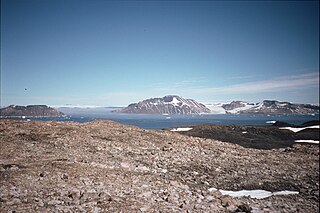
James Ross Island is a large island off the southeast side and near the northeastern extremity of the Antarctic Peninsula, from which it is separated by Prince Gustav Channel. Rising to 1,630 metres (5,350 ft), it is irregularly shaped and extends 40 nautical miles in a north–south direction.

<span class="mw-page-title-main">Vega Island</span> Island of Antarctica

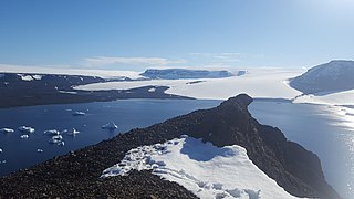
Vega Island is an island in Antarctica, 17 nautical miles long and 6 nautical miles wide, which is the northernmost of the James Ross Island group and lies in the west part of Erebus and Terror Gulf. It is separated from James Ross Island by Herbert Sound and from Trinity Peninsula by Prince Gustav Channel.

<span class="mw-page-title-main">Argentine Antarctica</span> Department in Tierra del Fuego, Argentina

Argentine Antarctica is an area on Antarctica claimed by Argentina as part of its national territory. It consists of the Antarctic Peninsula and a triangular section extending to the South Pole, delimited by the 25° West and 74° West meridians and the 60° South parallel. This region overlaps with British and Chilean claims in Antarctica. None of these claims have widespread international recognition.

<span class="mw-page-title-main">D'Urville Island, Antarctica</span>

D'Urville Island is the northernmost island of the Joinville Island group in Antarctica. It is 27 kilometres (17 mi) long, lying immediately north of Joinville Island, from which it is separated by Larsen Channel.

<span class="mw-page-title-main">Joinville Island group</span> Group of Antarctic islands

Joinville Island group is a group of antarctic islands, lying off the northeastern tip of the Antarctic Peninsula, from which Joinville Island group is separated by the Antarctic Sound.

<span class="mw-page-title-main">Nordenskjöld Coast</span> Coast in Antarctica

The Nordenskjöld Coast is located on the Antarctic Peninsula, more specifically Graham Land, which is the top region of the Peninsula. The Peninsula is a thin, long ice sheet with an Alpine-style mountain chain. The coast consists of 15m tall ice cliffs with ice shelves.

<span class="mw-page-title-main">Snow Hill Island</span> Island of Antarctica

Snow Hill Island is an almost completely snowcapped island, 33 km (21 mi) long and 12 km (7.5 mi) wide, lying off the east coast of the Antarctic Peninsula. It is separated from James Ross Island to the north-east by Admiralty Sound and from Seymour Island to the north by Picnic Passage. It is one of several islands around the peninsula known as Graham Land, which is closer to Chile, Argentina and South America than any other part of the Antarctic continent.

<span class="mw-page-title-main">Ulu Peninsula</span>

Ulu Peninsula is that portion of James Ross Island northwest of the narrow neck of land between Rohss Bay and Croft Bay, extending from Cape Obelisk to Cape Lachman, in Antarctica.

Andersson Island is an island 7 nautical miles long and 4 nautical miles wide, lying 0.5 nautical miles south of Jonassen Island at the west side of the south entrance to Antarctic Sound, off the northeast tip of the Antarctic Peninsula. It is a volcanic island of the James Ross Island Volcanic Group.

<span class="mw-page-title-main">Eagle Island, Antarctica</span> Island in Antarctica

Eagle Island is an island 5 nautical miles long and 4 nautical miles wide, rising to 560 metres (1,840 ft) on the NE side. It is the largest island in the archipelago which lies between Trinity Peninsula and Vega Island. Eagle Island is separated from the Antarctic mainland by the 1.77 km wide Aripleri Passage. It is volcanic in origin, having been K-Ar dated 1.7 ± 0.2 and 2.0 ± 0.2 million years old. It forms part of the James Ross Island Volcanic Group.

The Tabarin Peninsula is a peninsula 15 nautical miles long and 5 to 12 nautical miles wide, lying south of the trough between Hope Bay and Duse Bay and forming the east extremity of Trinity Peninsula in the Antarctic Peninsula.

<span class="mw-page-title-main">Croft Bay</span> Bay

Croft Bay is a bay which indents the north-central side of James Ross Island and forms the southern part of Herbert Sound, south of the northeastern end of the Antarctic Peninsula.

<span class="mw-page-title-main">Markham Bay (Antarctica)</span> Bay

Markham Bay is a bay 8 nautical miles wide, lying between Ekelöf Point and Hamilton Point on the east side of James Ross Island, Antarctica.

Argentina was one of the twelve original signatories of the Antarctic Treaty which was signed on December 1, 1959, and came in force on 21 June 1961.

<span class="mw-page-title-main">Penguin Point (Seymour Island)</span> Headland of Antarctica

Penguin Point lies on the south-eastern coast of Seymour Island, in the James Ross Island group, near the north-eastern extremity of the Antarctic Peninsula. The Argentine Marambio Base is about 8 km to the north-east. A ridge of exposed dark rock named Blackrock Ridge runs west-southwest–east-northeast, 1.5 nautical miles north of Penguin Point.

<span class="mw-page-title-main">La Meseta Formation</span>

The La Meseta Formation is a sedimentary sequence deposited during the Eocene on Seymour Island off the coast of the Antarctic Peninsula. It is noted for its fossils, which include both marine organisms and the only terrestrial vertebrate fossils from the Cenozoic of Antarctica.

<span class="mw-page-title-main">Röhss Bay</span> Bay

Röhss Bay is a bay 11 nautical miles wide, between Cape Broms and Cape Obelisk on the southwest side of James Ross Island, Antarctica.

<span class="mw-page-title-main">The Naze (James Ross Island)</span>

The Naze is a peninsula in north James Ross Island, marking the southeast entrance to Herbert Sound and extending about 5 nautical miles northeast from Terrapin Hill toward the south-central shore of Vega Island.

References

  1. Administered under the Antarctic Treaty System
  2. ESA Science & Technology: Graham Land
  3. "List of Historic Sites and Monuments approved by the ATCM (2012)" (PDF). Antarctic Treaty Secretariat. 2012. Retrieved 4 January 2014.
  4. Antarctic facilities Archived 2008-04-24 at the Wayback Machine – comnap.aq
  5. official page Archived 2013-12-03 at the Wayback Machine
  6. Watts, Jonathan (13 February 2020). "Antarctic temperature rises above 20C for first time on record". The Guardian. ISSN   0261-3077 . Retrieved 13 February 2020.
  7. "WMO verifies one temperature record for Antarctic continent and rejects another". World Meteorological Organization. 1 July 2021. Retrieved 3 July 2021.
  8. "WMO verifies highest temperatures for Antarctic Region". World Meteorological Organization. 1 March 2017. Archived from the original on 18 December 2023. Retrieved 13 February 2020.
  9. Tønnessen, Joh. N. (1982). The History of Modern Whaling. University of California Press. p. 150. ISBN   978-0-520-03973-5.
  10. Babcock, L. E.; Feldmann, R. M.; Grunow, A. M. (2024). "Cretaceous–Palaeogene lobsters, Hoploparia stokesi (Weller, 1903), from Antarctica: historical review, and transfer of specimens from the United States Polar Rock Repository". Polar Research. 43 (9866): 1–5. doi: 10.33265/polar.v43.9866 .
  11. 1 2 Zinsmeister, W.J. (1998). "Discovery of fish mortality horizon at the K-T Boundary on Seymour Island: Re-evaluation of events at the end of the Cretaceous". Journal of Paleontology. 72 (3): 556–571. doi:10.1017/S0022336000024331. S2CID   132206016.
  12. Elliot, D.H.; Askin, R.A.; Kyte, F.T.; Zinsmeister, W.J. (1994). "Iridium and dinocysts at the Cretaceous-Tertiary boundary on Seymour Island, Antarctica: Implications for the K-T event". Geology. 22 (8): 675. Bibcode:1994Geo....22..675E. doi:10.1130/0091-7613(1994)022<0675:IADATC>2.3.CO;2.
  13. Petersen, S.V.; Dutton, A.; Lohmann, K.C. (2016). "End-Cretaceous extinction in Antarctica linked to both Deccan volcanism and meteorite impact via climate change". Nature Communications. 7: 12079. Bibcode:2016NatCo...712079P. doi:10.1038/ncomms12079. PMC   4935969 . PMID   27377632.
  14. Witts, JD; Whittle, RJ; Wignall, PB; Crame, JA; Francis, JE; Newton, RJ; Bowman, VC (2016). "Macrofossil evidence for a rapid and severe Cretaceous-Paleogene mass extinction in Antarctica". Nature Communications. 7: 11738. Bibcode:2016NatCo...711738W. doi:10.1038/ncomms11738. PMC   4894978 . PMID   27226414.
  15. 1 2 "Middle Eocene Warming On Seymour Island, Antarctica: Continental Shelf Paleotemperatures Recorded In Molluscan Carbonates". Archived from the original on 21 August 2008. Retrieved 9 February 2007.
  16. Mörs, Thomas; Reguero, Marcelo; Vasilyan, Davit (2020). "First fossil frog from Antarctica: implications for Eocene high latitude climate conditions and Gondwanan cosmopolitanism of Australobatrachia". Scientific Reports. 10 (1): 5051. Bibcode:2020NatSR..10.5051M. doi:10.1038/s41598-020-61973-5. PMC   7181706 . PMID   32327670.
  17. Woodburne, Michael O.; Zinsmeister, William J. (October 1982). "Fossil Land Mammal from Antarctica". Science. 218 (4569): 284–286. Bibcode:1982Sci...218..284W. doi:10.1126/science.218.4569.284. PMID   17838631. S2CID   32304737.
  18. Goin, Francisco J.; et al. (December 1999). "New Discoveries of "Opposum-Like" Marsupials from Antarctica (Seymour Island, Medial Eocene)". Journal of Mammalian Evolution. 6 (4): 335–365. doi:10.1023/A:1027357927460. S2CID   2319361.
  19. Reguero, Marcelo A.; Marenssi, Sergio A.; Santillana, Sergio N. (May 2002). "Antarctic Peninsula and South America (Patagonia) Paleogene terrestrial faunas and environments: biogeographic relationships". Palaeogeography, Palaeoclimatology, Palaeoecology. 179 (3–4): 189–210. Bibcode:2002PPP...179..189R. doi:10.1016/S0031-0182(01)00417-5.
  20. Mills, William James. Exploring Polar Frontiers: A Historical Encyclopedia, ABC-CLIO, 2003. ISBN   1-57607-422-6, ISBN   978-1-57607-422-0
  21. Goin, F.J.; Reguero, M.A.; Pascual, R.; von Koenigswald, W.; Woodburne, M.O.; Case, J.A.; Marenssi, S.A.; Vieytes, C.; Vizcaíno, S.F. (2006). "First gondwanatherian mammal from Antarctica". Geological Society, London, Special Publications. 258 (1): 135–144. Bibcode:2006GSLSP.258..135G. doi:10.1144/GSL.SP.2006.258.01.10. S2CID   129493664.
  22. "The First 100 IUGS Geological Heritage Sites" (PDF). IUGS International Commission on Geoheritage. IUGS. Retrieved 10 November 2022.
  23. Alberts 1995, p. 413.
  24. Alberts 1995, p. 253.
  25. Alberts 1995, p. 418.
  26. Alberts 1995, p. 76.
  27. Alberts 1995, p. 63.
  28. Alberts 1995, p. 566, Penguin Point.
  29. Alberts 1995, p. 71.
  30. Alberts 1995, p. 163.
  31. Alberts 1995, p. 566, Penguin Bight.
  32. Alberts 1995, p. 818.
  33. Alberts 1995, p. 550.

Sources