
The Amargosa River is an intermittent waterway, 185 miles (298 km) long, in southern Nevada and eastern California in the United States. It drains a high desert region, the Amargosa Valley in the Amargosa Desert northwest of Las Vegas, into the Mojave Desert, and finally into Death Valley where it disappears into the ground aquifer. Except for a small portion of its route in the Amargosa Canyon in California and a small portion at Beatty, Nevada, the river flows above ground only after a rare rainstorm washes the region. A 26-mile (42 km) stretch of the river between Shoshone and Dumont Dunes is protected as a National Wild and Scenic River. At the south end of Tecopa Valley the Amargosa River Natural Area protects the habitat.
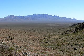
The Providence Mountains are found in the eastern Mojave Desert of San Bernardino County, California, U.S. The range reaches an elevation of 7,162 feet (2,183 m) at Edgar Peak and is home to the Mitchell Caverns Natural Preserve in the Providence Mountains State Recreation Area, and the Mojave National Preserve.

The Avawatz Mountains are located in San Bernardino County, California, in the Mojave Desert.
The Owlshead Mountains are located at the southern end of Death Valley National Park near the border of the Fort Irwin Military Reservation in San Bernardino County, California, US.
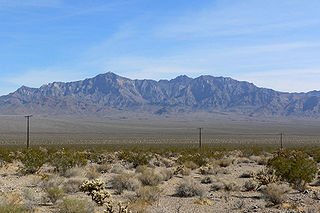
The Kingston Range, sometimes called the Kingston Mountains, is located in Inyo and San Bernardino counties in the Mojave Desert in eastern California. The range reaches a height of 7,323 feet (2,232 m) above sea level at Kingston Peak.

The Nopah Range is a mountain range located in Inyo County, California, United States, near the eastern border with Nevada.

The Silurian Hills are a small range of hills in the Mojave Desert, southeast of Death Valley National Park, in southern California. The surrounding lower elevation lands provide important connectivity habitat between nearby mountain ranges. The area provides critical habitat and movement corridors for bighorn sheep, desert tortoises, nesting golden eagles, kit foxes and burrowing owls. The Silurian Valley is a largely undisturbed valley that supports wildlife and is an important link for this portion of the northern Mojave Desert.

The Piute Range is located in the Mojave Desert, primarily in northeast San Bernardino County, California, United States, with a north portion in Nevada. Most of the range is the eastern border of the Mojave National Preserve, a National Park Service natural area and park.

Lanfair Valley is located in the Mojave Desert in southeastern California near the Nevada state line. It is bounded on the north by the New York Mountains and Castle Mountains, on the east by the Piute Range, and on the south by the Woods Mountains and Vontrigger Hills. Joshua Trees can be found in most of the valley. Elevation is 4,045 feet.

The Morongo Basin is an endorheic basin and valley region located in eastern San Bernardino County, in Southern California.

The Deserts of California, collectively known as the California Deserts, are a region of California made up of distinct deserts that each have unique ecosystems and habitats. The region is home to a sociocultural and historical "Old West" collection of legends, districts, and communities, and they also form a popular tourism region of dramatic natural features and recreational development.
The Dumont Hills are a low mountain range in the Mojave Desert, in northeastern San Bernardino County, southern California.
The Saddle Peak Hills are a mountain range in the Mojave Desert, in northern San Bernardino County, southern California.

The Salt Spring Hills are a low mountain range in the Mojave Desert, in northern San Bernardino County, California. They are just outside the southeastern corner of Death Valley National Park, southeast of the Saddle Peak Hills. The road between Shoshone and Baker passes through the hills.
The Sperry Hills are a low mountain range in the northern Mojave Desert—southern Amargosa Desert region, in northeastern San Bernardino County, southern California.
The Valjean Hills are a low mountain range in the eastern Mojave Desert, in northern San Bernardino County, southern California.
Shadow Valley is a north to northwest flowing drainage within the Mojave Desert of San Bernardino County, California. A section of Interstate 15 passes through the valley between Mountain Pass and Halloran Springs. The valley drains to the north from the west flank of the Mescal Range, the Ivanpah Mountains and Cima Dome within the Mojave National Preserve. North of I-15 the valley lies between Clark Mountains to the east and Shadow Mountain to the west. To the north of Shadow Mountain, Kingman Wash becomes the main drainage and turns to the west south of the Kingston Range. The Mesquite Mountains and the Mesquite Valley are to the northeast.
Bitter Spring is a spring within the Fort Irwin National Training Center in San Bernardino County, California. It lies at an elevation of 1355 feet and is located in a valley between the Soda Mountains to the east, the Tiefort Mountains to the northwest, Alvord Mountain to the southwest and Cronese Mountains to the south and southeast.
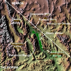
Silurian Valley is a valley in the Mojave Desert, in San Bernardino County, California. The valley trends in a north–south direction, its mouth located just southeast of the south end of Death Valley at 35°37′17″N116°16′07″W. Its head is at 35°23′36″N116°08′02″W. The valley is drained by Salt Creek a tributary of the Amargosa River and contains Silurian Lake and Dry Sand Lake.

Castle Mountains National Monument is a U.S. National Monument located in the eastern Mojave Desert and northeastern San Bernardino County, in the state of California.
