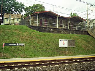
Sharon Hill station is a SEPTA Regional Rail station in Sharon Hill, Pennsylvania. It serves the Wilmington/Newark Line, with southbound service to Wilmington and Newark, Delaware and northbound service to Philadelphia. This station is about 1⁄2-mile (0.80 km) away from the Sharon Hill terminus of the SEPTA Route 102 trolley, although no direct connection exists between the two stations. It is not a staffed station and has no ticket machines. The historic station building, which was originally built in 1872, is abandoned and is to be restored. It is located at Sharon & Woodland Avenues. Amtrak trains pass through but do not stop.

SEPTA Routes 101 and 102 are light rail lines operated by the Suburban Transit Division of the Southeastern Pennsylvania Transportation Authority, serving portions of Delaware County. The route's eastern terminus is 69th Street Transportation Center in Upper Darby Township, Pennsylvania. Route 101 runs to Media, while Route 102 goes to Sharon Hill. Altogether, the two lines operate on approximately 11.9 miles (19.2 km) of route. The lines are one of the few remaining interurban systems in the United States, along with the South Shore Line in Indiana, the River Line in New Jersey, and the Norristown High Speed Line, also in the Philadelphia area.

The 69th Street Transportation Center is a SEPTA terminal in the Terminal Square section of Upper Darby Township, Pennsylvania. It serves the Market–Frankford Line, Norristown High Speed Line, and SEPTA Routes 101 and 102 trolleys, and multiple bus routes. It is located at the end of 69th Street, a major retail corridor in Upper Darby Township across Market Street from the Tower Theater. Until 2011, the station was primarily known as 69th Street Terminal.
The SEPTA subway–surface trolley lines are a collection of five SEPTA trolley lines that operate on street-level tracks in West Philadelphia and Delaware County, Pennsylvania, and also underneath Market Street in Philadelphia's Center City. The lines, Routes 10, 11, 13, 34, and 36, collectively operate on about 39.6 miles (63.7 km) of route.

Darby station is a SEPTA Regional Rail station in Darby, Pennsylvania. It is located on the Northeast Corridor at 4th and Colwyn Streets, and serves the Wilmington/Newark Line.

Clifton–Aldan station is a SEPTA station in Clifton Heights, Pennsylvania. It serves the Media/Wawa Line and is nearby the Clifton–Aldan station of the SEPTA Route 102 trolley. It is located at Springfield Road and West Maryland Avenue and has a 110-space parking lot. In 2013, this station saw 351 boardings and 329 alightings on an average weekday.

MacDade Boulevard station is SEPTA Route 102 trolley stop in Collingdale, Pennsylvania. The station is located on MacDade Boulevard. It is the last stop before Sharon Hill, and the last stop to run along Woodlawn Avenue. Trolleys arriving at this station travel between 69th Street Terminal in Upper Darby Township, Pennsylvania and Chester Pike down in Sharon Hill, Pennsylvania. The station has a shed with a roof where people can go inside when it is raining.

SEPTA Route 13, also known as the Chester Avenue Line, is a trolley line operated by the Southeastern Pennsylvania Transportation Authority (SEPTA) that connects 13th Street Station in downtown Philadelphia, Pennsylvania, with Yeadon and Darby, Pennsylvania. It is one of five lines that are part of the Subway-Surface Trolley system. From 2024 onwards, Route 13 will be referred as the T3 Chester Avenue Line

SEPTA's Subway-Surface Trolley Route 36 is a trolley line operated by the Southeastern Pennsylvania Transportation Authority (SEPTA) that connects the 13th Street station in downtown Philadelphia, Pennsylvania, to the Eastwick Loop station in Eastwick section of Southwest Philadelphia, although limited service is available to the Elmwood Carhouse. It is the longest of the five lines that are part of the Subway-Surface Trolley system, and was even longer between 1956 and 1962 when the western terminus was at 94th Street and Eastwick Avenue. From 1962 through the 1970s, it was at 88th Street and Eastwick Avenue, making the route 16.2 miles (26.1 km) long. Since 1975, it only goes as far as what was once 80th Street at the southern edge of the Penrose Plaza shopping center parking lot. From 2024, Route 36 will be referred to as the T5 Elmwood Avenue Line
The Baltimore Pike was an auto trail connecting Baltimore, Maryland, with Philadelphia, Pennsylvania.

Pennsylvania Route 3 is a 24.3-mile (39.1 km) state highway located in the southeastern portion of Pennsylvania. The route runs from U.S. Route 322 Business in West Chester east to PA 611 in Philadelphia.

U.S. Route 1 (US 1) is a major north–south U.S. Route, extending from Key West, Florida, in the south to Fort Kent, Maine, at the Canada–United States border in the north. In the U.S. state of Pennsylvania, US 1 runs for 81 miles (130 km) from the Maryland state line near Nottingham northeast to the New Jersey state line at the Delaware River in Morrisville, through the southeastern portion of the state. The route runs southwest to northeast and serves as a major arterial road through the city of Philadelphia and for many of the suburbs in the Delaware Valley metropolitan area. South of Philadelphia, the road mostly follows the alignment of the Baltimore Pike. Within Philadelphia, it mostly follows Roosevelt Boulevard. North of Philadelphia, US 1 parallels the route of the Lincoln Highway. Several portions of US 1 in Pennsylvania are freeways, including from near the Maryland state line to Kennett Square, the bypass of Media, the concurrency with Interstate 76 and the Roosevelt Expressway in Philadelphia, and between Bensalem Township and the New Jersey state line.

U.S. Route 13 (US 13) is a United States Numbered Highway running from Fayetteville, North Carolina, north to Morrisville, Pennsylvania. The route runs for 49.359 miles (79.436 km) through the Delaware Valley in the U.S. state of Pennsylvania. The route enters the state from Delaware in Marcus Hook, Delaware County. It continues northeast through Delaware County, passing through the city of Chester before heading through suburban areas along Chester Pike to Darby. US 13 enters the city of Philadelphia on Baltimore Avenue and runs through West Philadelphia to University City, where it turns north along several city streets before heading east across the Schuylkill River along Girard Avenue. The route turns north and heads to North Philadelphia, where it runs northeast along Hunting Park Avenue. US 13 becomes concurrent with US 1 on Roosevelt Boulevard, continuing into Northeast Philadelphia. US 13 splits southeast on a one-way pair of streets before heading northeast out of the city on Frankford Avenue. The route continues into Bucks County as Bristol Pike, heading northeast to Bristol, where it turns into a divided highway. US 13 becomes a freeway in Tullytown and continues north to its terminus at US 1 in Falls Township, near Morrisville. US 13 roughly parallels Interstate 95 (I-95) through its course in Pennsylvania.

SEPTA's Trolley Route 60, the Allegheny Avenue Line is a former streetcar line and current bus route, operated by the Southeastern Pennsylvania Transportation Authority (SEPTA) in Northwest and Northeast Philadelphia, Pennsylvania, United States. It connects to the East Falls to the Port Richmond, and runs primarily along Allegheny Avenue.

Congress Avenue station is a SEPTA Media-Sharon Hill Trolley Line stop in Upper Darby Township, Pennsylvania. It is located at Garrett Road and Congress Avenue, and serves both Routes 101 and 102. Only local service is provided on both lines. The station is located on the north side of the terminus of the Congress Avenue intersection. It contains two platforms, but only one pre-fabricated shelter on the south side of the tracks.

Baltimore Avenue station is a SEPTA Route 102 trolley stop in Clifton Heights, Pennsylvania. It is officially located near Baltimore Pike & Odgen Street, however the shed is located on the opposite side of this intersection between Glenwood and Bridge Avenues.

SEPTA Route 103 is a bus route operated by the Southeastern Pennsylvania Transportation Authority (SEPTA) on the outskirts of Philadelphia, Pennsylvania, United States. Route 103 runs between Ardmore and the 69th Street Transportation Center in Upper Darby.
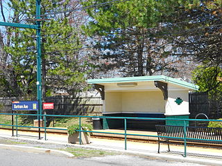
Bartram Avenue station is a SEPTA Route 102 trolley station in Collingdale, Pennsylvania. The station is officially located at Woodlawn and Bartram Avenues. This is the fourth to last station stop on the Route 102 line, and the third to last stop to run along Woodlawn Avenue.
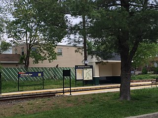
Andrews Avenue station is SEPTA Route 102 trolley stop in Collingdale, Pennsylvania. The station is officially located at Woodlawn & Andrews Avenues. This is the third to last station stop on the Route 102 line, and the second to last stop to run along Woodlawn Avenue.
Germantown Pike is a historic road in Pennsylvania that opened in 1687, running from Philadelphia northwest to Collegeville. The road is particularly notable for the "imposing mansions" that existed in the Germantown neighborhood in Philadelphia. The road was left in ruins after the British destroyed it in the Revolutionary War during the 1777 Battle of Germantown, and was not rebuilt until 1809. Portions of Germantown Pike were signed as U.S. Route 422 (US 422) before the latter was rerouted along a freeway alignment to King of Prussia.
