
Belle Meade is a city in Davidson County, Tennessee. Its total land area is 3.1 square miles (8.0 km2), and its population was 2,912 at the time of the 2010 census.

Belmont University is a private Christian university in Nashville, Tennessee. Descended from Belmont Women's College, founded in 1890 by schoolteachers Ida Hood and Susan Heron, the institution was incorporated in 1951 as Belmont College. It became Belmont University in 1991. Belmont's current enrollment consists of approximately 8,900 students representing every state and 28 nations. The university served as the host site for the final presidential debate in the 2020 election cycle. Although the university cut its ties with the Tennessee Baptist Convention in 2007, it continues to emphasize a Christian identity.

Patterson Park is an urban park in Southeast Baltimore, Maryland, United States, adjacent to the neighborhoods of Canton, Highlandtown, Patterson Park, and Butchers Hill. It is bordered by East Baltimore Street, Eastern Avenue, South Patterson Park Avenue, and South Linwood Avenue. The Patterson Park extension lies to the east of the main park, and is bordered by East Pratt Street, South Ellwood Avenue, and Eastern Avenue.

Irving Park is one of 77 officially designated Chicago community areas, and is located on the Northwest Side. It is bounded by the Chicago River on the east, the Milwaukee Road railroad tracks on the west, Addison Street on the south and Montrose Avenue on the north, west of Pulaski Road stretching to encompass the region between Belmont Avenue on the south and, roughly, Leland Avenue on the north. It is named after the American author Washington Irving.

Herschel Greer Stadium was a Minor League Baseball park in Nashville, Tennessee, on the grounds of Fort Negley, an American Civil War fortification, approximately two mi (3.2 km) south of the city's downtown district. The facility closed at the end of the 2014 baseball season and remained deserted for over four years until its demolition in 2019. Following an archaeological survey, the land is expected to be reincorporated into Fort Negley Park.
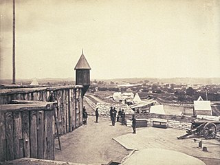
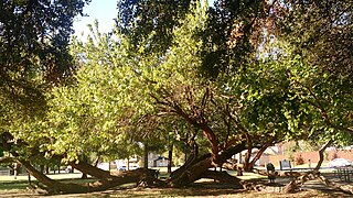
Fort Negley was a fortification built by Union troops after the capture of Nashville, Tennessee during the American Civil War, located approximately 2 miles (3.2 km) south of the city center. It was the largest inland fort built in the United States during the war.

Pompano Beach Airpark is a public airport located one mile (1.6 km) northeast of the central business district of Pompano Beach, in Broward County, Florida, United States. This airport is publicly owned by the City of Pompano Beach.
The Whitten Soccer Complex was the on-campus soccer complex for the Belmont Bruins of Belmont University in Nashville, Tennessee, the largest Christian university in Tennessee.

Belmont is a primarily residential neighborhood in the Bronx in New York City. Its boundaries are Fordham Road to the north, Bronx Park to the east, East 181st Street to the south, and Third Avenue to the west. These boundaries give the neighborhood a crescent-like shape. The neighborhood is noted for its "close-knit community" and "small-town feel", and as a result of its cultural history and wide array of Italian businesses, is widely known as the "Little Italy of the Bronx". Arthur Avenue, noted for its local restaurants and markets, is its primary thoroughfare.

Edwin Warner Park and Percy Warner Park, collectively known as Warner Parks, are two major public parks in Nashville, Tennessee. They are part of the park system managed by the Metropolitan Board of Parks and Recreation of Nashville and Davidson County. Percy Warner Park's front entrance is located at the end of Belle Meade Boulevard. The parks are listed on the National Register of Historic Places as Warner Park Historic District. The district is primarily within Nashville along the southern edge of Davidson County, Tennessee, but it extends into Williamson County, Tennessee as well.
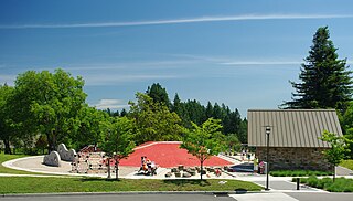
Wilsonville Memorial Park is a large municipal park in Wilsonville, Oregon, United States. Opened in 1969, the 126-acre (51 ha) park is the largest and oldest in the city. Located off Wilsonville Road east of Interstate 5, the park includes a plaza with water features, athletic fields and courts, trails, a skatepark, picnic areas, a dog park, and playground equipment. Part of the park fronts the Willamette River and includes a public boat dock.
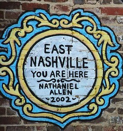
East Nashville is an area east of downtown Nashville in Tennessee across the Cumberland River. The area is mostly residential and mixed-use areas with businesses lining the main boulevards. The main thoroughfares are Gallatin Ave and Ellington Parkway, with smaller arteries interconnecting the neighborhoods. Some of these smaller arteries include Main Street, Shelby Avenue, Porter Road, Riverside Drive, Eastland Avenue, McFerrrin Avenue, and Woodland Street in no significant order. Ellington Parkway, which parallels Gallatin Ave and Main Street, bypasses I-24 and I-65 and connects Briley Parkway and downtown Nashville and many other secondary streets along the way. The Cumberland River confines most of the area with a semicircle design on the south, southwest and east. Since East Nashville has no defined boundaries on the west and north the exact perimeter is the cause of some debate. Some would say that Ellington Parkway creates a boundary on the west and northwest, while Cahal Avenue and Porter Road create the northern boundary, in the confines of zipcode 37206. Many would also state that with I-65 and I-24 as the western border and Briley Parkway as the northern boundary, this defines an area that constitutes Greater East Nashville. East Nashville is one of about 26 suburban neighborhoods in Nashville.
The Belmont Bruins are the intercollegiate athletic teams of Belmont University located in Nashville, Tennessee, United States. The Bruins athletic program is a member of the Missouri Valley Conference. Prior to 2022, the Bruins were members of the Ohio Valley Conference (OVC) and competes at the NCAA Division I level.

Peninsula Park is a public park in the Piedmont neighborhood of Portland, Oregon, United States. The 16.27-acre (6.58 ha) park is located in the North Portland neighborhood and contains an outdoor swimming pool, community center, baseball fields, playgrounds, basketball courts, tennis courts, covered picnic areas, a historic gazebo and other amenities. In 2007, area residents started to propose a piece of public art be added to the park honoring Rosa Parks, as the park lies along Rosa Parks Way.

The Belmont Bruins baseball team is a varsity intercollegiate athletic team of Belmont University in Nashville, Tennessee, United States. The team is a member of the Missouri Valley Conference, which is part of the National Collegiate Athletic Association's Division I. The team plays its home games at E. S. Rose Park in Nashville. The Bruins are coached by Dave Jarvis.

Cornelia Fort Airpark was a privately owned, public-use airport located five nautical miles northeast of the central business district of Nashville, in Davidson County, Tennessee, United States. Cornelia Fort was the first female pilot to die on war duty in American history and the airpark was built in 1945 near her family farm. The 141-acre airport was located on part of a plot of land granted to early Nashvillian Ephraim McLean for service in the Revolutionary War, near what is still known as McLean's Bend in the Cumberland River in East Nashville. The airport operated from 1944 until 2011, when the city of Nashville acquired it to include it as non-aviation part of Shelby Park.
E. S. Rose Park is a baseball, softball, soccer, and track & field venue in Nashville, Tennessee, United States. It is home to Nashville Union FC and Belmont Bruins baseball, softball, men's and women's soccer, and men's and women's track & field teams of the NCAA Division I Ohio Valley Conference. It is located approximately five minutes from Belmont University's main campus. The city-owned park was renovated extensively in 2010–2011.
The Belmont Bruins men's soccer team represents Belmont University in NCAA Division I soccer. The Bruins currently play in the Missouri Valley Conference (MVC). From 2018 to 2021 the Bruins played in the Southern Conference (SoCon), and prior to that played in the Horizon League. The Bruins play their home matches at the soccer stadium in the sports complex located at the city of Nashville's E. S. Rose Park. A former Division II All-American and long-time collegiate assistant coach, Bryan Green has been the Bruins' head coach since 2014.
Lakewood Heights is a residential neighborhood in Dallas, Texas (USA), bounded by Abrams Road to the east, Monticello Avenue to the north, Skillman Street to the west, and Richmond Avenue to the south. It located in East Dallas. Lakewood Heights is approximately one-half mile (0.8 km) wide (east-west) and three-quarters of a mile (1.2 km) long (north-south). It covers approximately 240 acres or slightly less than 0.375 square miles (1000m²). It is adjacent to several East Dallas neighborhoods, including Lakewood, Lower Greenville, and Wilshire Heights.
The Land Trust for Tennessee is an American non-profit conservation organization working to protect Tennessee's natural, scenic and historic landscapes and sites. Since 1999, The Land Trust has partnered to conserve more than 131,000 acres (530 km2) of land across 65-plus Tennessee counties.

