The Don Valley Parkway (DVP) is a municipal freeway in Toronto, Ontario, Canada, which connects the Gardiner Expressway in downtown Toronto with Highway 401. North of Highway 401, it continues as Highway 404. The parkway runs through the parklands of the Don River valley, after which it is named. It has a maximum speed limit of 90 km/h (56 mph) for its entire length of 15.0 km (9.3 mi). It is six lanes for most of its length, with eight lanes north of York Mills Road and four lanes south of Eastern Avenue. As a municipal road, it is patrolled by the Toronto Police Service.

The Prince Edward Viaduct System, commonly referred to as the Bloor Viaduct, is the name of a truss arch bridge system in Toronto, Ontario, Canada, connecting Bloor Street East, on the west side of the system, with Danforth Avenue on the east. The system includes the Rosedale Valley phase and the Sherbourne Phase, an embankment built to extend Bloor Street East to the Rosedale Ravine from Sherbourne Street. The Don Valley phase of the system, the most recognizable, spans the Don River Valley, crossing over the Bayview Avenue Extension, the Don River, and the Don Valley Parkway.

Gerrard Street is a street in Toronto, Ontario, Canada. It consists of two separate parts, historically referred to as Lower Gerrard and Upper Gerrard. The former stretches between University Avenue and Coxwell Avenue for 6 km, across Old Toronto. The latter portion starts 300 m north of Lower Gerrard's eastern terminus and runs between Coxwell Avenue and Clonmore Drive, between Victoria Park Avenue and Warden Avenue, in Scarborough for another 4 km.

The Credit River is a river in southern Ontario, which flows from headwaters above the Niagara Escarpment near Orangeville and Caledon East to empty into Lake Ontario at Port Credit, Mississauga. It drains an area of approximately 1,000 square kilometres (390 sq mi). The total length of the river and its tributary streams is over 1,500 kilometres (930 mi).

Bayview Village is a neighbourhood in Toronto, Ontario, Canada. It is part of the federal Don Valley North riding and the provincial Don Valley North electoral district, and Toronto electoral Ward 17: Don Valley North. In 2006, it had a population of 15,370.

Sheppard Avenue is an east–west principal arterial road in Toronto, Ontario, Canada. The street has two distinct branches near its eastern end, with the original route being a collector road leading to Pickering via a turnoff, and the main route following a later-built roadway which runs south to Kingston Road. To avoid name duplication, the Toronto portion of the northern branch was renamed Twyn Rivers Drive. The section of the street entirely in Toronto is (34.2 km) in length, while the Pickering section and Twyn Rivers Dr. is (5.4 km) long.

Hoggs Hollow Bridge, originally known as the Yonge Boulevard Viaduct, is a set of four separate highway bridges that span the West Branch of the Don River Valley in Toronto, Ontario, Canada, and carries 14 lanes of Highway 401. The four structures are the busiest multi-span bridge crossing in North America, surpassing the Brooklyn Bridge.

The Sir Isaac Brock Bridge is a steel Warren truss bridge in Toronto, Ontario, Canada. It lies along Bathurst Street over the railway tracks between Front Street and Fort York Boulevard. The bridge carries four lanes for motor vehicles with the centre lanes containing the streetcar tracks of the Toronto Transit Commission's 511 Bathurst streetcar route.

The Old Eastern Avenue Bridge consists of two bridges spanning the Don River in Toronto, Ontario, Canada. The north bridge or Gas Line Bridge is a concrete arch bridge built for Consumer's Gas Company and is used by Enbridge Gas to carry a major gas main. The southern Howe truss bridge, similar to Queen Street Viaduct and Sir Isaac Brock Bridge, previously carried traffic on Eastern Avenue but is currently unused.

Don Valley Village is a neighbourhood in the city of Toronto, Ontario, Canada. It is located in the former suburb of North York. Located north of Highway 401 and bisected by Don Mills Road, it is bounded by Sheppard Avenue to the south, Leslie Street to the west, Finch Avenue to the north and Highway 404 to the east. Like the nearby Don River Valley, the neighbourhood has hill and dale topography.

The Medway Viaducts are three bridges or viaducts that cross the River Medway between Cuxton and Borstal in north Kent, England. The two road bridges carry the M2 motorway carriageways. The other viaduct carries the High Speed 1 railway line linking London and the Channel Tunnel. All three bridges pass over the Medway Valley Line.
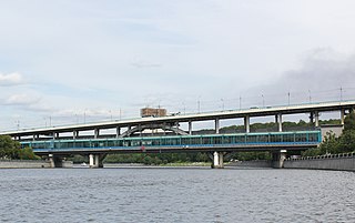
Luzhniki Metro Bridge, also known as Metromost (Метромост), is a concrete double-decked (two-level) arch bridge carrying a road and a Moscow Metro line across the Moskva River in Moscow, Russia. It connects the neighbourhood of Luzhniki Stadium to Sparrow Hills. The bridge houses Vorobyovy Gory, the only station of Moscow Metro located over water. Designed in 1958 by V.G. Andreyev and N.N. Rudomasin, the bridge rapidly decayed and was rebuilt in 1997–2002.

Highland Creek is a river in the Scarborough district of Toronto, Ontario, emptying into Lake Ontario at the eastern end of the Scarborough Bluffs. It is home to several species of fish including trout, carp, bass and salmon. It is a meandering river which, like most rivers in Toronto, travels through a glacial ravine formed after the last Ice Age. The Highland Creek watershed, including tributaries, is almost entirely contained within Scarborough.

The Bayview Bridge is a Deck truss bridge over the West Don River in Toronto, Ontario, Canada. The six-lane bridge carries Bayview Avenue across the Don Valley, connecting with Lawrence Avenue East at its southern end. Built in 1929 by Harold Babcock, the bridge helped spur the development of the Bridle Path, an affluent neighbourhood northeast of the bridge's span.

The Peats Ferry Bridge is a steel truss bridge that carries the Pacific Highway (B83) across the Hawkesbury River, between Kangaroo Point and Mooney Mooney Point, located 40 kilometres (25 mi) north of Sydney in New South Wales, Australia. The bridge carries the Hornsby to Kariong section of highway, while the adjacent Brooklyn Bridge carries the Pacific Motorway (M1).
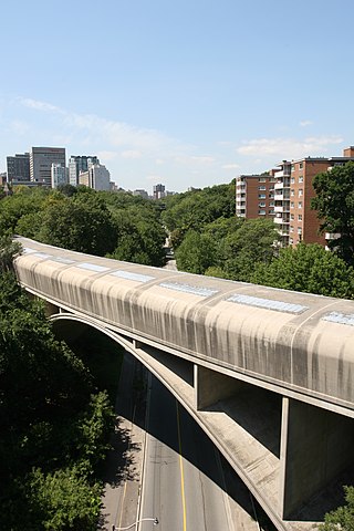
The Rosedale Valley Bridge is a covered arch bridge located in the northeast part of Downtown Toronto, Ontario. Built in 1966 by architect John B. Parkin, the concrete bridge carries Line 2 trains of the subway across the Rosedale Ravine.

Villiers Island is a 22-hectare (54-acre) area in Toronto's Port Lands being converted to an island. The project is a part of Port Lands Flood Protection Project by Waterfront Toronto. To prevent flooding from the Don River, a channel is being created to extend the river south and then west into Toronto Harbour providing another outlet and a more natural mouth for the Don River. The new channel effectively creates the island, which is also bounded by the Keating Channel and Toronto Harbour. Mixed-use residential development is planned for Villiers Island.

Yellow Creek is a partially-buried southeasterly tributary of the Don River in Toronto. It has also been known at different times as Silver Creek, Sylvan Creek, and Rosedale Brook. The former source of Yellow Creek begins near Sheppard West station in the Downsview neighbourhood. Most of the creek and its sources are buried underground in storm sewers until they emerge into Avoca Ravine in the Deer Park neighbourhood and continue their way to the Don River.

