
Al-Mansura, was a Palestinian village that was depopulated by the Israeli army during the 1948 Arab-Israeli war. In 1945, it had a population of 2,300 together with the neighboring villages of Dayr al-Qassi and Fassuta. The population was predominantly Christian and most its residents live in what is now the state of Israel.

Tarbikha, was a Palestinian Arab village. It was located 27 kilometres northeast of Acre in the British Mandate District of Acre that was captured and depopulated by the Israel Defense Forces during the 1948 Arab-Israeli war. The inhabitants of this village were, similar to the inhabitants of Southern Lebanon, Shia Muslims.

Al-Khisas, also known as Khisas or Khissas, was a Palestinian Arab village in the Safad Subdistrict in Mandatory Palestine. It was located 31 kilometers (19 mi) northeast of Safed on a natural terrace about 100 meters (330 ft) wide that formed when Lake al-Hula receded. To the west of the village was a valley known as Wadi al-Hasibani through which ran the Hasbani River.

Al-Malikiyya was a Palestinian village located in the Jabal Amil region. In a 1920s census, the village was registered as part of Greater Lebanon. It was later placed under the British Mandate of Palestine. Its population was mostly Metawali Shiite.

Avivim, is a moshav in the far north of Israel, in the Upper Galilee. It is located less than one kilometre from the Blue Line with Lebanon. In 2019 its population was 471.
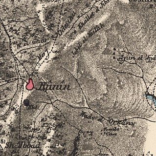
Hunin was a Palestinian Arab village in the Galilee Panhandle part of Mandatory Palestine close to the Lebanese border. It was the second largest village in the district of Safed, but was depopulated in 1948. The inhabitants of this village were, similar to the inhabitants of Southern Lebanon, Shia Muslims.
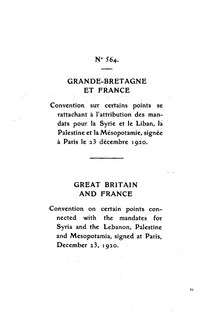
The Paulet–Newcombe Agreement or Paulet-Newcombe Line, was a 1923 agreement between the British and French governments regarding the position and nature of the boundary between the Mandates of Palestine and Iraq, attributed to Great Britain, and the Mandate of Syria and Lebanon, attributed to France. The 1923 line defined the border of Mandatory Palestine from the Mediterranean up to Al-Hamma, Tiberias. The 1920 line defined, in less detail, the border of the French Mandate for Syria and Lebanon from the Mediterranean up to Jeziret-ibn-Omar.

Islam is a major religion in Palestine, being the religion of the majority of the Palestinian population. Muslims comprise 85% of the population of the West Bank, when including Israeli settlers, and 99% of the population of the Gaza Strip. The largest denomination among Palestinian Muslims are Sunnis at 98-99% of total population.

The modern borders of Israel exist as the result both of past wars and of diplomatic agreements between the State of Israel and its neighbours as well as colonial powers. Only two of Israel's five total potential land borders are internationally recognized and uncontested, while the other three remain disputed; the majority of its border disputes are rooted in territorial changes that came about as a result of the 1967 Arab–Israeli War, which saw Israel occupy large swathes of territory from its rivals. Israel's two formally recognized and confirmed borders exist with Egypt and Jordan since the 1979 Egypt–Israel peace treaty and the 1994 Israel–Jordan peace treaty, while its borders with Syria, Lebanon and the Palestinian territories remain internationally recognized as contested.

Qadas was a Palestinian village located 17 kilometers northeast of Safad that was depopulated during the 1948 Arab-Israeli war. One of seven Shia Muslim villages, called Metawalis, that fell within the boundaries of British Mandate Palestine, Qadas lay adjacent to al-Nabi Yusha', near the tell of the ancient biblical city of Kedesh Naftali. The village of Qadas contained many natural springs which served as the village water supply and a Roman temple dating back to the 2nd century AD.
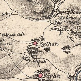
Saliha, sometimes transliterated Salha, meaning 'the good/healthy place', was a Palestinian Arab village located 12 kilometres northwest of Safed.

Qaddita was a Palestinian Arab village of 240, located 4.5 kilometers (2.8 mi) northwest of Safad. It was captured and depopulated in the 1948 Arab-Israeli War, with some of its inhabitants expelled or fleeing to nearby Akbara where they live as internally displaced Palestinians and others to refugee camps in Lebanon or Syria.

Abil al-Qamh was a Palestinian village located near the Lebanese border north of Safad. It was depopulated in 1948. It was located at the site of the biblical city of Abel-beth-maachah.

Al-Nabi Yusha' (Arabic: النبي يوشع was a small Palestinian village in the Galilee situated 17 kilometers to the northeast of Safad, with an elevation of 375 meters above sea level. It became part of the Palestine Mandate under British control from 1923 until 1948, when it was depopulated during the 1948 Arab-Israeli War. The village was surrounded by forest land overlooking the Hula Valley.
Al-Husayniyya was a Palestinian village, depopulated in 1948.

Khubbayza was a Palestinian Arab village in the Haifa Subdistrict, located 29.5 kilometers (18.3 mi) southeast of Haifa. It was situated on hilly terrain, south of Wadi al-Sindiyana, between the Jezreel Valley with the Mediterranean coast. In 1945, it had a population of 290. Khubbayza was depopulated during the 1948 War on May 12, 1948, in the Battle of Mishmar HaEmek.

Al-Barriyya was a Palestinian village in the Ramle Subdistrict of Mandatory Palestine. It was depopulated during the 1948 Arab–Israeli War on July 10, 1948, as part of Operation Dani. It was located 5.5 km southeast of Ramla, on the eastern bank of Wadi al-Barriyya.

Al-Wayziyya was a Palestinian village in the Safad Subdistrict, located south east of Yarda. It was depopulated during the 1947–48 Civil War in Mandatory Palestine on May 1, 1948, by the Palmach's First Battalion of Operation Yiftach. It was located 8.5 km northeast of Safad.

Al-Nuqayb was a Palestinian Arab village in the Tiberias Subdistrict. It was depopulated during the 1948 Arab-Israeli War on May 15, 1948. It was located 10 km east across the lake from Tiberias. bordering the Wadi al-Muzaffar and Wadi Samakh. al-Nuqayb was named after the Bedouin tribe of 'Arab al-Nuqayb.

Al-Manshiyya, also known as Khirbat Manshiyya, was a Palestinian Arab village in the Tulkarm Subdistrict. It was depopulated during the 1947–48 Civil War in Mandatory Palestine on April 15, 1948, under Operation Coastal Clearing. It was located 12.5 km northwest of Tulkarm.
