Shrewsbury, Missouri

Last updated

Shrewsbury, Missouri
Shrewsbury (9878460416).jpg
St. Louis County Missouri Incorporated and Unincorporated areas Shrewsbury Highlighted.svg
Location of Shrewsbury, Missouri
Coordinates: 38°35′12″N90°19′41″W / 38.58667°N 90.32806°W / 38.58667; -90.32806
Country United States
State Missouri
County St. Louis
Area
[1]
  Total1.44 sq mi (3.73 km2)
  Land1.44 sq mi (3.73 km2)
  Water0.00 sq mi (0.00 km2)
Elevation
[2]
522 ft (159 m)
Population
 (2020)
  Total6,406
  Density4,445.52/sq mi (1,716.09/km2)
Time zone UTC-6 (Central (CST))
  Summer (DST) UTC-5 (CDT)
FIPS code 29-67700 [3]
GNIS feature ID2395878 [2]
Website www.cityofshrewsbury.com

Shrewsbury is an inner-ring suburb of St. Louis, located in St. Louis County, Missouri, United States. The population was 6,254 at the 2010 census. [4]

Contents

History

Shrewsbury welcome sign, 2018 Shrewsbury, MO sign.jpg
Shrewsbury welcome sign, 2018

Shrewsbury was officially platted in 1889. The land which became Shrewsbury originally belonged to Gregorie Sarpy and Charles Gratiot; by 1890, it was divided into farms and sold to families. The area now known as Shrewsbury was a 278-acre (1.13 km2) farm owned by General John Murdoch. The Murdoch farm was called Shrewsbury Park, named after a town in England.

In 1913, concerned resident Joseph Burge organized the Shrewsbury Improvement Association to improve Shrewsbury and develop its first sewer system. Shrewsbury was incorporated and became a village in 1913; shortly thereafter a sanitation system was established, reducing water-borne diseases prevalent at the time.

In 1938, the United States government offered financial aid to the city of Shrewsbury, and land was acquired for the construction of a new city hall replacing the 1912 original. The new City Hall building was completed in October 1938. Shrewsbury's new fire engine house and state-of-the-art equipment were dedicated in 1947; it was during this period that the Shrewsbury Garden Club was formed to maintain the beautiful trees and flowers throughout the city. The early 1950s were marked by the expansion of the public bus routes to connect Shrewsbury to St. Louis. The 1960s and '70s were times of great community growth, noted by the construction of city parks, a municipal pool, and Interstate 44.

The 1980s and '90s saw increased development of new homes, condominiums, apartments, shopping areas, and a new and improved City Center, which opened May 8, 1993, to coincide with Shrewsbury's 80th year of incorporation. With the opening of the City Center, the previous City Hall building was converted to house the police and fire departments, and is now called the Public Safety Building. [5]

Construction finished in 2006 on the Shrewsbury–Lansdowne Interstate 44 St. Louis MetroLink station on the eastern edge of the city, at Lansdowne Avenue and River Des Peres Boulevard.

Shrewsbury is home to the seminary of the Roman Catholic Archdiocese of Saint Louis, Kenrick–Glennon Seminary.

The Shrewsbury City Council in fall 2010 was expected to consider a plan to turn Kenrick Plaza, which has several open storefronts, into a Walmart store.

Geography

According to the United States Census Bureau, the city has a total area of 1.43 square miles (3.70 km2), all land. [6]

The city is roughly bounded by St. Louis to the east, Webster Groves to the north, Marlborough to the west and Mackenzie and Affton to the south.

Children in Shrewsbury attend Webster Groves and Affton school districts.

Demographic

Historical population
CensusPop.Note
1920 845
1930 1,52580.5%
1940 2,18243.1%
1950 3,38255.0%
1960 4,73039.9%
1970 5,89624.7%
1980 5,077−13.9%
1990 6,41626.4%
2000 6,6443.6%
2010 6,254−5.9%
2020 6,4062.4%
U.S. Decennial Census [7]

2020 census

As of 2020, there were 6,406 people living in the city. [8]

2010 census

As of the census [9] of 2010, there were 6,254 people, 3,218 households, and 1,331 families living in the city. The population density was 4,373.4 inhabitants per square mile (1,688.6/km2). There were 3,487 housing units at an average density of 2,438.5 per square mile (941.5/km2). The racial makeup of the city was 90.4% White, 3.6% African American, 0.2% Native American, 3.9% Asian, 0.5% from other races, and 1.4% from two or more races. Hispanic or Latino of any race were 2.3% of the population.

There were 3,218 households, of which 16.3% had children under the age of 18 living with them, 32.3% were married couples living together, 7.1% had a female householder with no husband present, 2.1% had a male householder with no wife present, and 58.6% were non-families. 50.0% of all households were made up of individuals, and 23.3% had someone living alone who was 65 years of age or older. The average household size was 1.84 and the average family size was 2.76.

The median age in the city was 42.9 years. 14.2% of residents were under the age of 18; 10.4% were between the ages of 18 and 24; 27.6% were from 25 to 44; 23.5% were from 45 to 64; and 24.2% were 65 years of age or older. The gender makeup of the city was 45.3% male and 54.7% female.

2000 census

As of the census [3] of 2000, there were 6,644 people, 3,266 households, and 1,407 families living in the city. The population density was 4,655.4 inhabitants per square mile (1,797.5/km2). There were 3,390 housing units at an average density of 2,375.4 per square mile (917.1/km2). The racial makeup of the city was 93.98% White, 1.48% African American, 0.18% Native American, 2.63% Asian, 0.02% Pacific Islander, 0.54% from other races, and 1.17% from two or more races. Hispanic or Latino of any race were 1.69% of the population.

There were 3,266 households, out of which 17.3% had children under the age of 18 living with them, 34.0% were married couples living together, 7.5% had a female householder with no husband present, and 56.9% were non-families. 47.5% of all households were made up of individuals, and 22.5% had someone living alone who was 65 years of age or older. The average household size was 1.91 and the average family size was 2.80.

In the city, the population was spread out, with 15.6% under the age of 18, 10.8% from 18 to 24, 29.8% from 25 to 44, 17.4% from 45 to 64, and 26.3% who were 65 years of age or older. The median age was 40 years. For every 100 females, there were 78.9 males. For every 100 females age 18 and over, there were 74.2 males.

The median income for a household in the city was $40,896, and the median income for a family was $57,007. Males had a median income of $40,951 versus $35,018 for females. The per capita income for the city was $27,479. About 3.1% of families and 8.7% of the population were below the poverty line, including 3.8% of those under age 18 and 5.2% of those age 65 or over.

Transportation

Public transportation

Shrewsbury is served by the Blue Line of the St. Louis region's MetroLink light rail system. The city has one station, Shrewsbury–Lansdowne I-44, which is located within the city limits of St. Louis in the Lindenwood Park neighborhood despite being named for Shrewsbury. Metro Transit also operates the Shrewsbury Transit Center on Lansdowne Avenue, which connects the light rail station to several MetroBus routes and paratransit services.[ citation needed ]

Major roads and highways

Major arterial routes in Shrewsbury include Big Bend Boulevard, Laclede Station Road, Lansdowne Avenue, Murdoch Avenue and Watson Road. Interstate 44 passes through the northern part of the city near Deer Creek.

Related Research Articles

<span class="mw-page-title-main">Dover, Florida</span> CDP in Florida, United States

Dover is an unincorporated census-designated place in Hillsborough County, Florida, United States. The population was 3,266 at the 2020 census, down from 3,702 at the 2010 census.

<span class="mw-page-title-main">McKinley, St. Louis County, Minnesota</span> City in Minnesota, United States

McKinley is a city in Saint Louis County, Minnesota, United States; located within the Iron Range region of Minnesota. The population was 128 at the 2010 census.

<span class="mw-page-title-main">New Melle, Missouri</span> City in Missouri, United States

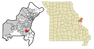
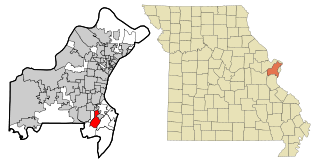
New Melle is a small country community in St. Charles County, Missouri, United States. It is located approximately 38 miles west of St. Louis. The population was 475 at the 2010 census.

<span class="mw-page-title-main">Affton, Missouri</span> Census-designated place in Missouri, United States

Affton is a census-designated place (CDP) in south St. Louis County, Missouri, United States, near St. Louis. The population was 20,417 at the 2020 United States Census.

<span class="mw-page-title-main">Beverly Hills, Missouri</span> City in Missouri, United States

Beverly Hills is a city in St. Louis County, Missouri, United States. As of the 2010 census, the city population was 574.

<span class="mw-page-title-main">Cool Valley, Missouri</span> City in Missouri, United States

Cool Valley is a city in St. Louis County, Missouri, United States in Greater St. Louis. The population was 1,196 at the 2010 census.

<span class="mw-page-title-main">Crestwood, Missouri</span> City in Missouri, United States

Crestwood is a city in south St. Louis County, Missouri, United States, part of the Metropolitan Statistical Area known as Greater St. Louis. The population was 11,912 at the 2010 census.

<span class="mw-page-title-main">Dellwood, Missouri</span> City in Missouri, United States

Dellwood is a city in the north St. Louis County, Missouri, United States. The population was 5,025 at the 2010 census. The center of Dellwood or the city of Dellwood was located at the intersections of West Florissant Ave. and Chambers Road.

<span class="mw-page-title-main">Green Park, Missouri</span> City in Missouri, United States

Green Park is a city in St. Louis County, Missouri, United States. The population was 2,622 at the 2010 census.

<span class="mw-page-title-main">Hillsdale, Missouri</span> Village in Missouri, United States

Hillsdale is a village in St. Louis County, Missouri, United States. Hillsdale consists of 67th, 68th, 69th, St.Louis Ave and sometimes Rosebud. Hillsdale is also home of Greenwood Cemetery. The population was 1,478 at the 2010 census.

<span class="mw-page-title-main">Huntleigh, Missouri</span> City in Missouri, United States

Huntleigh is a city in St. Louis County, Missouri, United States. The population was 334 at the 2010 census.

<span class="mw-page-title-main">Lakeshire, Missouri</span> City in Missouri, United States

Lakeshire is a city in St. Louis County, Missouri, United States. The population was 1,432 at the 2010 census.

<span class="mw-page-title-main">Maplewood, Missouri</span> City in Missouri, United States

Maplewood is an inner-ring suburb of St. Louis, located in St. Louis County, Missouri, United States.

<span class="mw-page-title-main">Northwoods, Missouri</span> City in Missouri, United States

Northwoods is a city in St. Louis County, Missouri, United States. The population was 4,227 at the 2010 census.

<span class="mw-page-title-main">St. John, Missouri</span> City in Missouri, United States

St. John or Saint John is a city in St. Louis County, Missouri, United States, with its commercial district centered along St. Charles Rock Road. It is a few miles southeast of Lambert-St. Louis International Airport.

<span class="mw-page-title-main">Velda City, Missouri</span> City in Missouri, United States

Velda City is a city in St. Louis County, Missouri, United States. The population was 1,420 at the 2010 census.

<span class="mw-page-title-main">Wildwood, Missouri</span> City in Missouri, United States

Wildwood is a city in St. Louis County, Missouri, United States. It is located in the far western portion of the county. As of the 2020 census, the population was 35,417. Wildwood is the home of the Al Foster Trail, and numerous other trails, parks, and reserves such as Rockwoods Reservation and Babler State Park.

<span class="mw-page-title-main">Concord, Missouri</span> CDP in Missouri, United States

Concord is a census-designated place (CDP) in St. Louis County, Missouri, United States. The population was 16,421 at the 2010 census. It should not be confused with Concord Township; which the CDP shares much land with, but these areas' boundaries are not identical.

<span class="mw-page-title-main">Shrewsbury Township, York County, Pennsylvania</span> Township in Pennsylvania, United States

Shrewsbury Township is a township in York County, Pennsylvania, United States. The population was 6,651 at the 2020 census.

<span class="mw-page-title-main">Bonney Lake, Washington</span> City in Washington, United States

Bonney Lake is a city in Pierce County, Washington. The population was 22,487 at the time of the 2020 census.

References

  1. "ArcGIS REST Services Directory". United States Census Bureau. Retrieved August 28, 2022.
  2. 1 2 U.S. Geological Survey Geographic Names Information System: Shrewsbury, Missouri
  3. 1 2 "U.S. Census website". United States Census Bureau . Retrieved January 31, 2008.
  4. "Race, Hispanic or Latino, Age, and Housing Occupancy: 2010 Census Redistricting Data (Public Law 94-171) Summary File (QT-PL), Shrewsbury city, Missouri". United States Census Bureau . Retrieved October 24, 2011.
  5. "History of Shrewsbury". City of Shrewsbury official website. City of Shrewsbury. Retrieved December 1, 2011.
  6. "US Gazetteer files 2010". United States Census Bureau. Archived from the original on January 12, 2012. Retrieved July 8, 2012.
  7. "Census of Population and Housing". Census.gov. Retrieved June 4, 2015.
  8. "CINYC Maps" . Retrieved September 30, 2021.
  9. "U.S. Census website". United States Census Bureau . Retrieved July 8, 2012.