
The Okanagan, also called the Okanagan Valley and sometimes the Okanagan Country, is a region in the Canadian province of British Columbia defined by the basin of Okanagan Lake and the Canadian portion of the Okanagan River. It is part of the Okanagan Country, extending into the United States as Okanogan County in north-central Washington. According to the 2016 Canadian census, the region's population is 362,258. The largest populated cities are Kelowna, Penticton, Vernon, and West Kelowna.
Highway 3A is the designation of two segments of highway in the southern part of British Columbia.

Osoyoos is the southernmost town in the Okanagan Valley in British Columbia between Penticton and Omak. The town is 3.6 km (2.2 mi) north of the United States border with Washington state and is adjacent to the Osoyoos Indian reserve. The origin of the name Osoyoos was the word sw̓iw̓s meaning "narrowing of the waters" in the local Okanagan language (Syilx'tsn). The "O-" prefix is not indigenous in origin and was attached by settler-promoters wanting to harmonize the name with other place names beginning with O in the Okanagan region. There is one local newspaper, the Osoyoos Times.

British Columbia Southern Interior was a federal electoral district in the province of British Columbia, Canada, that had been represented in the House of Commons of Canada from 1997 to 2015.
Yale–Cariboo was a federal electoral district in British Columbia, Canada, that was represented in the House of Commons of Canada from 1896 to 1917.
Yale-Lillooet was a provincial electoral district for the Legislative Assembly of British Columbia, Canada.

The Similkameen River runs through southern British Columbia, Canada, eventually discharging into the Okanagan River near Oroville, Washington, in the United States. Through the Okanagan River, it drains to the Columbia River. The river is said to be named for an indigenous people called Similkameigh, meaning "treacherous waters".
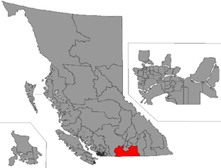
Boundary-Similkameen is a provincial riding formed in 2008. It includes the populations of Penticton-Okanagan Valley, West Kootenay-Boundary and Yale-Lillooet. The riding's name corresponds to that of a former riding in the same area, with similar but not identical boundaries.
Okanagan-Boundary was a provincial electoral district in the Canadian province of British Columbia spanning the area from the Similkameen towns of Kaleden and Keremeos to Grand Forks and Christina Lake, and including the southern Okanagan towns of Okanagan Falls, Oliver, Osoyoos, Rock Creek and Greenwood. The riding first appeared in the 1991 election as the result of a redistribution of the former riding of Boundary-Similkameen. The same area is now part of West Kootenay-Boundary.

Keremeos is a village in the Southern Interior of British Columbia, Canada. The name originated from the Similkameen dialect of the Okanagan language word "Keremeyeus" meaning "creek which cuts its way through the flats" referring to Keremeos Creek which flows down from the Upper Benchlands to the Similkameen River that flows past the village.

The Regional District of Okanagan-Similkameen (RDOS) is in southern British Columbia, adjacent to the U.S. state of Washington. It is bounded by Fraser Valley Regional District to the west, Thompson-Nicola Regional District and Regional District of Central Okanagan to the north, Regional District of Kootenay Boundary to the east, and by Okanogan County, Washington to the south. At the 2011 census the population was 80,742. The district covers a land area of 10,413.44 square kilometres (4,020.65 sq mi). The administrative offices are in the City of Penticton.

Cawston is an unincorporated small community in the south Similkameen Valley, with a 2005 population of 973.
School District 53 Okanagan Similkameen is a school district that serves fragments of the southern Okanagan and lower Similkameen regions, which include Cawston, Hedley, Keremeos, Okanagan Falls, Oliver, and Osoyoos, totaling to six communities in the district, all of which are in British Columbia, Canada. Its main "maintenance department" office is held in Oliver, consisting of ten schools, five of which are elementary, three are high or secondary schools, while two are alternative schools. This district's superintendent is Marcus Toneatto, while 2,665 students attend schools in it; there are 480 employees for the Okanagan Simlkammen school district. Their motto is "Learning Today for Living Tomorrow", and all places within the district are towns or villages.
The Lower Similkameen Indian Band or Lower Smelqmix, is a First Nations band government in the Canadian province of British Columbia. Their office was in the village of Keremeos in the Similkameen region, until 2015 when they moved into their own $7million multi-purpose facility south of Cawston. They are a member of the Okanagan Nation Alliance.
The Okanagan Nation Alliance is a First Nations Tribal Council in the Canadian province of British Columbia, spanning the Nicola, Okanagan and Similkameen Districts of the Canadian province of British Columbia and also the Colville Indian Reservation in Washington state of the United States of America. Their territory covers roughly 69,000 km2 in the Canadian Province of British Columbia and also some area of Washington state in the United States of America. The diverse landscape covers deserts, lakes, forests, and grasslands.
The Okanagan Basin spans two countries and comprises the basin of Okanagan Lake, the Okanogan River and tributary valleys such as that of the Similkameen and Chelan Rivers. In Canada the basin constitutes two distinct regions within British Columbia, the Similkameen Country to the west and the main Okanagan region running from the communities of Osoyoos in the south to Armstrong in the north – incorporating most of the three Okanagan regional districts and is usually known as "the Okanagan" or as the Okanagan Valley or the Okanagan Country. In the United States, the Okanogan Country is the western, lowland core of Okanogan County, which like its Canadian counterpart has a history and economy based on ranching, gold, fruit orcharding and vineyards, but the basin includes Lake Chelan and other flanking valleys. Communities in Washington's Okanogan Basin include Pateros, Omak, Okanogan, Oroville and Brewster.
Franz Xavier Richter, commonly known as Frank Richter, was a pioneer settler, miner and rancher in 19th century Washington and British Columbia.
Chopaka is an unincorporated community in the Similkameen region of south central British Columbia. Immediately north of the Canada–United States border, the population centre is on the west shore of the Similkameen River. The Nighthawk–Chopaka Border Crossing lies to the east. Off BC Highway 3, the locality is by road about 96 kilometres (60 mi) southeast of Princeton and 75 kilometres (47 mi) south of Penticton.

The Ashnola River is a tributary of the Similkameen River, rising in the northeastern part of the North Cascades in Washington, United States, and flowing north into British Columbia, Canada, to join the Similkameen River about halfway along that river's course between the towns of Princeton and Keremeos. The river crosses the international boundary at 49°00′00″N120°19′37″W and transits Cathedral Provincial Park. It has one main tributary, Ewart Creek, which is about 25 kilometres (16 mi) long and begins virtually at the border and is entirely within Cathedral Park.
Richter Pass is a mountain pass to the south of the summit of British Columbia Highway 3 between Keremeos (W) and Osoyoos (E), linking the Similkameen Valley with the South Okanagan over the southernmost end of the Thompson Plateau. The pass is traversed by Old Richter Pass Road and is ~650 m (2,130 ft) in elevation though the name is generally used for the route of Highway 3 as well.