Sims Corner Eskers and Kames

Last updated
Sims Corner Eskers and Kames
Mixed-Eratics-PB110053.JPG
Mixed erratics located near Sims Corner. The nearest is basalt, while the ones behind it are granite.
USA Washington location map.svg
Red pog.svg
Map of Washington state
Locationnorth central Washington state
Coordinates 47°49′30″N119°22′00″W / 47.82500°N 119.36667°W / 47.82500; -119.36667 Coordinates: 47°49′30″N119°22′00″W / 47.82500°N 119.36667°W / 47.82500; -119.36667
Designated1986

Sims Corner Eskers and Kames National Natural Landmark and nearby McNeil Canyon Haystack Rocks and Boulder Park natural landmarks contain excellent examples of Pleistocene glacial landforms. Sims Corner Eskers and Kames National Natural Landmark includes classic examples of ice stagnation landforms such as glacial erratics, terminal moraines, eskers, and kames. It is located on the Waterville Plateau of the Columbia Plateau in north central Washington state in the United States. [1]

National Natural Landmark national natural areas program in the United States

The National Natural Landmarks (NNL) Program recognizes and encourages the conservation of outstanding examples of the natural history of the United States. It is the only national natural areas program that identifies and recognizes the best examples of biological and geological features in both public and private ownership. The program was established on May 18, 1962, by United States Secretary of the Interior Stewart Udall.

Boulder Park

Boulder Park National Natural Landmark, along with the nearby McNeil Canyon Haystack Rocks and Sims Corner Eskers and Kames natural landmarks, illustrate well-preserved examples of classic Pleistocene ice stagnation landforms that are found in Washington. These landforms include numerous glacial erratics and haystack rocks that occur near and on the Withrow Moraine, which is the terminal moraine of the Okanogan ice lobe.

Glacial erratic piece of rock that differs from the size and type of rock native to the area in which it rests

A glacial erratic is a piece of rock that differs from the size and type of rock native to the area in which it rests. "Erratics" take their name from the Latin word errare, and are carried by glacial ice, often over distances of hundreds of kilometres. Erratics can range in size from pebbles to large boulders such as Big Rock in Alberta.

Contents

Geologic History

Esker near Sims Corner. Note trees next to esker and the single lane road crossing the esker to the right of the photo which provide scale. Esker-PB110050.JPG
Esker near Sims Corner. Note trees next to esker and the single lane road crossing the esker to the right of the photo which provide scale.

The plateau

The Sims Corner Eskers and Kames National Natural Landmark is located on the Waterville Plateau, which lies in the northwest corner of the Columbia River Plateau. The plateau is formed on top of the Columbia River Basalt Group, a large igneous province that lies across parts of the states of Washington, Oregon, and Idaho in the United States of America. During late Miocene and early Pliocene times, one of the largest flood basalts ever to appear on the earth's surface engulfed about 163,700 km2 (63,000 mile2) of the Pacific Northwest, forming a large igneous province with an estimated volume of 174,300 km3. Eruptions were most vigorous from 1714 million years ago, when over 99% of the basalt was released. Less extensive eruptions continued from 146 million years ago.

Columbia River Basalt Group

The Columbia River Basalt Group is the youngest, smallest and one of the best-preserved continental flood basalt province on Earth, covering over 210,000 km2 (81,000 sq mi) mainly eastern Oregon and Washington, western Idaho, and part of northern Nevada. The basalt group includes the Steen and Picture Gorge basalt formations.

Large igneous province Huge regional accumulation of igneous rocks

A large igneous province (LIP) is an extremely large accumulation of igneous rocks, including intrusive and extrusive, arising when magma travels through the crust towards the surface. The formation of LIPs is variously attributed to mantle plumes or to processes associated with divergent plate tectonics. The formation of some of the LIPs the past 500 million years coincide in time with mass extinctions and rapid climatic changes, which has led to numerous hypotheses about the causal relationships. LIPs are fundamentally different from any other currently active volcanoes or volcanic systems.

Oregon U.S. state in the United States

Oregon is a state in the Pacific Northwest region on the West Coast of the United States. The Columbia River delineates much of Oregon's northern boundary with Washington, while the Snake River delineates much of its eastern boundary with Idaho. The parallel 42° north delineates the southern boundary with California and Nevada.

These lava flows have been extensively exposed by the erosion resulting from the Missoula Floods, which laid bare many layers of the basalt flows on the edges of the plateau at Grand Coulee and Moses Coulee. [2] [3] [4] [5] [6]

Missoula Floods Cataclysmic floods at the end of the last ice age, in eastern Washington state, USA

The Missoula Floods refer to the cataclysmic floods that swept periodically across eastern Washington and down the Columbia River Gorge at the end of the last ice age. The glacial flood events have been researched since the 1920s. These glacial lake outburst floods were the result of periodic sudden ruptures of the ice dam on the Clark Fork River that created Glacial Lake Missoula. After each ice dam rupture, the waters of the lake would rush down the Clark Fork and the Columbia River, flooding much of eastern Washington and the Willamette Valley in western Oregon. After the rupture, the ice would reform, creating Glacial Lake Missoula again.

Grand Coulee An ancient river bed in the U.S. state of Washington

The Grand Coulee is an ancient river bed in the U.S. state of Washington. This National Natural Landmark stretches for about 60 miles southwest from Grand Coulee Dam to Soap Lake, being bisected by Dry Falls into the Upper and Lower Grand Coulee.

Moses Coulee A canyon in the Waterville plateau region of Douglas County, Washington

Moses Coulee is a canyon in the Waterville plateau region of Douglas County, Washington. Moses Coulee is the second-largest and westernmost canyon of the Channeled Scablands, located about 30 kilometres (19 mi) to the west of the larger Grand Coulee. This water channel is now dry, but during glacial periods, large outburst floods with discharges greater than 600,000 m3/s (21,000,000 cu ft/s) carved the channel. While it's clear that megafloods from Glacial Lake Missoula passed through and contributed to the erosion of Moses Coulee, the origins of the coulee are less clear. Some researchers propose that floods from glacial Lake Missoula formed Moses Coulee, while others suggest that subglacial floods from the Okanogan Lobe incised the canyon. The mouth of Moses Coulee discharges into the Columbia River.

The glacial history

Illustration of the glacial impacts. Waterville Plateau.jpg
Illustration of the glacial impacts.

Two million years ago the Pleistocene epoch began and ice age glaciers invaded the area. They scoured the Columbia River Plateau, reaching as far south as the middle of the Waterville Plateau highlands above the Grand Coulee and south to the head of Moses Coulee. In some areas north of the Grand Coulee they were as much as 3 km (10,000 feet) thick. Grooves in the exposed granite bedrock are still visible in the area from the movement of glaciers and numerous glacial erratics in the elevated to the northwest of the coulee. [1] [2] [3]

The Pleistocene is the geological epoch which lasted from about 2,588,000 to 11,700 years ago, spanning the world's most recent period of repeated glaciations. The end of the Pleistocene corresponds with the end of the last glacial period and also with the end of the Paleolithic age used in archaeology.

Ice age Period of long-term reduction in temperature of Earths surface and atmosphere

An ice age is a long period of reduction in the temperature of the Earth's surface and atmosphere, resulting in the presence or expansion of continental and polar ice sheets and alpine glaciers. Earth is currently in the Quaternary glaciation, known in popular terminology as the Ice Age. Individual pulses of cold climate are termed "glacial periods", and intermittent warm periods are called "interglacials" or "interstadials" with both climatic pulses part of the Quaternary or other periods in Earth's history.

Creation of the Foster Coulee, Moses Coulee, and Grand Coulee

Terminal moraine with multiple erratics at the terminus of the Okanogan Lobe on the Waterville Plateau. Erratics-PB110026.JPG
Terminal moraine with multiple erratics at the terminus of the Okanogan Lobe on the Waterville Plateau.

The Okanogan lobe of the Cordilleran Glacier moved down the Okanogan River valley and blocked the ancient route of the Columbia River, backing up water to create Lake Spokane. Initially water discharged from Lake Spokane by running up through the head of Grand Coulee and down through Foster Coulee to rejoin the Columbia River. As the glacier moved further south, Foster Coulee was cut off and the Columbia River then discharged through Moses Coulee, which runs southward slightly to the east of the ancient and current course of the Columbia. As the Okanogan lobe grew, it blocked Moses Coulee as well; the Columbia found the next lowest route through the region which was eroded to become the modern Grand Coulee. Flowing across the current Grand Coulee and Dry Falls regions, the ice age Columbia then entered the Quincy Basin and joined Crab Creek, following Crab Creek’s course southward past the Frenchman Hills and turning west to run along the north face of the Saddle Mountains and rejoin the previous and modern course of the Columbia River just above the main water gap in the Saddle Mountains, Sentinel Gap. [1]

Cordilleran Ice Sheet

The Cordilleran ice sheet was a major ice sheet that periodically covered large parts of North America during glacial periods over the last ~2.6 million years. This included the following areas:

Okanogan River river

The Okanogan River is a tributary of the Columbia River, approximately 115 mi (185 km) long, in southern British Columbia and north central Washington. It drains a scenic plateau region called the Okanagan Country east of the Cascade Range and north and west of the Columbia, and also the Okanagan region of British Columbia. The Canadian portion of the river has been channelized since the mid-1950s.

Foster Coulee is a coulee in Douglas County, Washington. Like the larger Moses Coulee nearby, it was formed during the Missoula Floods at the end of the last ice age, some 14,000 years ago.

See also

Related Research Articles

Kame Mound formed on a retreating glacier and deposited on land

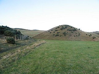
A kame is a glacial landform, an irregularly shaped hill or mound composed of sand, gravel and till that accumulates in a depression on a retreating glacier, and is then deposited on the land surface with further melting of the glacier. Kames are often associated with kettles, and this is referred to as kame and kettle topography. The word kame is a variant of comb, which has the meaning "crest" among others. The geological term was introduced by Thomas Jamieson in 1874.

Channeled Scablands Landscape in eastern Washington, USA scoured by cataclysmic floods during the Pleistocene epoch

The Channeled Scablands at one time were a relatively barren and soil-free region of interconnected relict and dry flood channels, coulees and cataracts eroded into Palouse loess and the typically flat-lying basalt flows that remain after cataclysmic floods within the southeastern part of the U.S. state of Washington. The channeled scablands were scoured by more than 40 cataclysmic floods during the Last Glacial Maximum and innumerable older cataclysmic floods over the last two million years. These cataclysmic floods were repeatedly unleashed when a large glacial lake repeatedly drained and swept across eastern Washington and down the Columbia River Plateau during the Pleistocene epoch. The last of the cataclysmic floods occurred between 18,200 and 14,000 years ago.

The Confederated Tribes of the Colville Reservation is the federally recognized tribe that controls the Colville Indian Reservation, which is located in northeastern Washington, United States. It is the government for its people.

Glacial landform Landform created by the action of glaciers

Glacial landforms are landforms created by the action of glaciers. Most of today's glacial landforms were created by the movement of large ice sheets during the Quaternary glaciations. Some areas, like Fennoscandia and the southern Andes, have extensive occurrences of glacial landforms; other areas, such as the Sahara, display rare and very old fossil glacial landforms.

Palouse River river in the United States of America

The Palouse River is a tributary of the Snake River in Washington and Idaho, in the northwest United States. It flows for 167 miles (269 km) southwestwards, primarily through the Palouse region of southeastern Washington. It is part of the Columbia River Basin, as the Snake River is a tributary of the Columbia River.

Dry Falls Scalloped precipice with four major alcoves, in central Washington scablands

Dry Falls is a 3.5-mile-long (5,600 m), 5.5 km in width, scalloped precipice with four major alcoves, in central Washington scablands. This cataract complex is on the opposite side of the Upper Grand Coulee from the Columbia River, and at the head of the Lower Grand Coulee, northern end of Lenore Canyon. According to the current geological model, catastrophic flooding channeled water at 65 miles per hour through the Upper Grand Coulee and over this 400-foot (120 m) rock face at the end of the last ice age. It is estimated that the falls were five times the width of Niagara, with ten times the flow of all the current rivers in the world combined.

Lake Lewis lake in United States of America

Lake Lewis was a temporary lake in the Pacific Northwest region of North America, largely formed by the Missoula Floods in about the 14th millennium B.C.

Drumheller Channels National Natural Landmark Example in the Columbia Plateau of basalt butte-and-basin Channeled Scablands

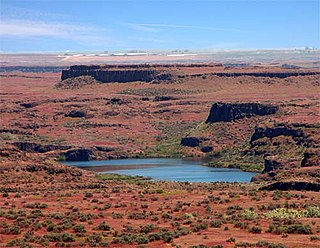
Drumheller Channels National Natural Landmark showcases the Drumheller Channels, which are the most significant example in the Columbia Plateau of basalt butte-and-basin Channeled Scablands. This National Natural Landmark is an extensively eroded landscape, located in south central Washington state characterized by hundreds of isolated, steep-sided hills (buttes) surrounded by a braided network of numerous channels, all but one of which are currently dry. It is a classic example of the tremendous erosive powers of extremely large floods such as those that reformed the Columbia Plateau volcanic terrain during the late Pleistocene glacial Missoula Floods.

Withrow Moraine and Jameson Lake Drumlin Field

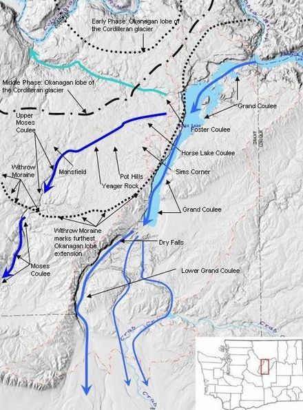
The Withrow Moraine and Jameson Lake Drumlin Field is a National Park Service–designated privately owned National Natural Landmark located in Douglas County, Washington state, United States. Withrow Moraine is the only Ice Age terminal moraine on the Waterville Plateau section of the Columbia Plateau. The drumlin field includes excellent examples of glacially-formed elongated hills.

Crab Creek

Crab Creek is a stream in the U.S. state of Washington. Named for the presence of crayfish, it is one of the few perennial streams in the Columbia Basin of central Washington, flowing from the northeastern Columbia River Plateau, roughly 5 km (3.1 mi) east of Reardan, west-southwest to empty into the Columbia River near the small town of Beverly. Its course exhibits many examples of the erosive powers of extremely large glacial Missoula Floods of the late Pleistocene, which scoured the region. In addition, Crab Creek and its region have been transformed by the large-scale irrigation of the Bureau of Reclamation's Columbia Basin Project (CBP), which has raised water table levels, significantly extending the length of Crab Creek and created new lakes and streams.

Saddle Mountains

The Saddle Mountains consists of an upfolded anticline ridge of basalt in Grant County of central Washington state. The ridge, reaching to 2,700 feet, terminates in the east south of Othello, Washington near the foot of the Drumheller Channels. It continues to the west where it is broken at Sentinel Gap before ending in the foothills of the Cascade Mountains.

Withrow, Washington human settlement in Washington, United States of America

Withrow is an unincorporated community in Douglas County, Washington, United States.

Ice Age Floods National Geologic Trail

The Ice Age Floods National Geologic Trail or Ice Age Floods Trail is designated as the first National Geologic Trail in the United States. It will consist of a network of routes connecting facilities that will provide interpretation of the geological consequences of the Glacial Lake Missoula floods of the last glacial period that began about 110,000 years ago.

Lake Condon was a temporary lake in the Pacific Northwest region of North America, formed periodically by the Missoula Floods from 15,000 to 13,000 BC.

Glacial Lake Columbia

Glacial Lake Columbia was the lake formed on the ice-dammed Columbia River behind the Okanogan lobe of the Cordilleran Ice Sheet when the lobe covered 500 square miles (1,300 km2) of the Waterville Plateau west of Grand Coulee in central Washington state during the Wisconsin glaciation. Lake Columbia was a substantially larger version of the modern-day lake behind the Grand Coulee Dam. Lake Columbia's overflow – the diverted Columbia River – drained first through Foster Coulee, and as the ice dam grew, through first Moses Coulee, and finally, the Grand Coulee.

References

  1. 1 2 3 Mueller, Marge & Ted (1997). Fire, Faults and Floods . University of Idaho Press, Moscow, Idaho. ISBN   0-89301-206-8.
  2. 1 2 Alt, David. Glacial Lake Missoula & its Humongous Floods. Mountain Press Publishing Company. ISBN   0-87842-415-6.
  3. 1 2 Bjornstad, Bruce (2006). On the Trail of the Ice Age Floods: A Geological Guide to the Mid-Columbia Basin. Keokee Books; Sand Point, Idaho. ISBN   978-1-879628-27-4.
  4. Portions of this article, including a figure, are adapted from works of the United States Government, which are in the public domain
  5. Alt, David & Hyndman, Donald (1995). Northwest Exposures: a Geologic Story of the Northwest. Mountain Press Publishing Company. ISBN   0-87842-323-0.
  6. Carson, Robert J.; Pogue, Kevin R. (1996). Flood Basalts and Glacier Floods:Roadside Geology of Parts of Walla Walla, Franklin, and Columbia Counties, Washington. Washington State Department of Natural Resources (Washington Division of Geology and Earth Resources Information Circular 90). ISBN none.