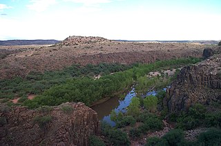
The Verde Valley is a valley in central Arizona in the United States. The Verde River runs through it. The Verde River is one of Arizona's last free-flowing river systems. It provides crucial habitat for fish and wildlife, fresh water for local agricultural production, recreational opportunities for locals and tourists alike, and brings clean drinking water to over 2 million people in the greater Phoenix area. The valley is overlooked by Mingus Mountain and the Mogollon Rim. The valley is one of three regions of viticulture in Arizona and contains the Verde Valley AVA.

Montezuma Castle National Monument protects a set of well-preserved dwellings located in Camp Verde, Arizona, which were built and used by the Sinagua people, a pre-Columbian culture closely related to the Hohokam and other indigenous peoples of the southwestern United States, between approximately AD 1100 and 1425. The main structure comprises five stories and about 20 rooms and was built over the course of three centuries.

The Wupatki National Monument is a United States National Monument located in north-central Arizona, near Flagstaff. Rich in Native American archaeological sites, the monument is administered by the National Park Service in close conjunction with the nearby Sunset Crater Volcano National Monument. Wupatki was established as a national monument in 1924 and was listed on the National Register of Historic Places on October 15, 1966. The listing included three contributing buildings and 29 contributing structures on 35,422 acres (14,335 ha).
Indigenous peoples of Arizona are the Native American people who currently live or have historically lived in what is now the state of Arizona. There are 22 federally recognized tribes in Arizona, including 17 with reservations that lie entirely within its borders. Reservations make up over a quarter of the state's land area. Arizona has the third largest Native American population of any U.S. state.

Northern Arizona is an unofficial, colloquially-defined region of the U.S. state of Arizona. Generally consisting of Apache, Coconino, Mohave, Navajo, and Gila counties, the region is geographically dominated by the Colorado Plateau, the southern border of which in Arizona is called the Mogollon Rim.

Walnut Canyon National Monument is a United States National Monument located about 10 mi (16 km) southeast of downtown Flagstaff, Arizona, near Interstate 40. The canyon rim elevation is 6,690 ft (2,040 m); the canyon's floor is 350 ft lower. A 0.9 mi (1.4 km) long loop trail descends 185 ft (56 m) into the canyon passing 25 cliff dwelling rooms constructed by the Sinagua, a pre-Columbian cultural group that lived in Walnut Canyon from about 1100 to 1250 AD. Other contemporary habitations of the Sinagua people are preserved in the nearby Tuzigoot and Montezuma Castle national monuments.
North Central Arizona is a geographical region of Arizona. It is in the Transition Zone between the Basin and Range Province and the Colorado Plateau, and has some of the most rugged and scenic landscapes in Arizona.

Mogollon culture is an archaeological culture of Native American peoples from Southern New Mexico and Arizona, Northern Sonora and Chihuahua, and Western Texas. The northern part of this region is Oasisamerica, while the southern span of the Mogollon culture is known as Aridoamerica.

Jesse Walter Fewkes was an American anthropologist, archaeologist, writer, and naturalist.

The Palatki Heritage Site is an archaeological site and park located in the Coconino National Forest, near Sedona, in Arizona, United States at approximately 34 55' 4"N, 111 53' 59"W. In the Hopi language Palatki means 'red house'.

Oasisamerica is a cultural region of Indigenous peoples in North America. Their precontact cultures were predominantly agrarian, in contrast with neighboring tribes to the south in Aridoamerica. The region spans parts of Northwestern Mexico and Southwestern United States and can include most of Arizona and New Mexico; southern parts of Utah and Colorado; and northern parts of Sonora and Chihuahua. During some historical periods, it might have included parts of California and Texas as well.

Montezuma Well, a detached unit of Montezuma Castle National Monument, is a natural limestone sinkhole near the town of Lake Montezuma, Arizona, through which some 1,500,000 US gallons of water emerge each day from an underground spring. It is located about 11 miles (18 km) northeast of Montezuma Castle.

The Honanki Heritage Site is a cliff dwelling and rock art site located in the Coconino National Forest, about 15 miles (24 km) west of Sedona, Arizona. The Sinagua people of the Ancestral Puebloans, and ancestors of the Hopi people, lived here from about 1100 to 1300 CE. The Palatki Heritage Site is nearby, also in the Coconino National Forest.

Tuzigoot National Monument preserves a 2- to 3-story pueblo ruin on the summit of a limestone and sandstone ridge just east of Clarkdale, Arizona, 120 feet (37 m) above the Verde River floodplain. The Tuzigoot Site is an elongated complex of stone masonry rooms that were built along the spine of a natural outcrop in the Verde Valley. The central rooms stand higher than the others and they appear to have served public functions. The pueblo has 110 rooms. The National Park Service currently administers 58 acres, within an authorized boundary of 834 acres.

Hundreds of Ancestral Puebloan dwellings are found across the American Southwest. With almost all constructed well before 1492 CE, these Puebloan towns and villages are located throughout the geography of the Southwest.

The Pueblo III Period was the third period, also called the "Great Pueblo period" when Ancestral Puebloans lived in large cliff-dwelling, multi-storied pueblo, or cliff-side talus house communities. By the end of the period, the ancient people of the Four Corners region migrated south into larger, centralized pueblos in central and southern Arizona and New Mexico.

Flagstaff is a city in, and the county seat of, Coconino County in northern Arizona, in the southwestern United States. Established as a modern settlement in 1876 and incorporated as a city in 1928, the land had previously been lived on by native peoples of the southwest, primarily the Sinagua. Mountaineer Antoine Leroux then traveled the area, with Edward Fitzgerald Beale following in his footsteps and establishing a trail through the city in the mid-1800s. With a local spring, a small settlement grew by the wagon road, and the town was dominated by the McMillan, Riordan, and Babbitt families. Focused on agricultural pursuits, these families constructed some historic red stone buildings that still stand today.

The Indigenous peoples of the North American Southwest are those in the current states of Colorado, Arizona, New Mexico, Utah, and Nevada in the western United States, and the states of Sonora and Chihuahua in northern Mexico. An often quoted statement from Erik Reed (1666) defined the Greater Southwest culture area as extending north to south from Durango, Mexico to Durango, Colorado and east to west from Las Vegas, Nevada to Las Vegas, New Mexico. Other names sometimes used to define the region include "American Southwest", "Northern Mexico", "Chichimeca", and "Oasisamerica/Aridoamerica". This region has long been occupied by hunter-gatherers and agricultural people.
The Puebloans of the southwestern United States and northern Mexico are descended from various peoples who had settled in the area, and shaped by the arrival of Spanish colonizers led by Juan de Oñate at the end of the 16th Century. There are three primary cultures: Mogollon, Hohokam and Ancestral Puebloen. They developed significant buildings and culture prior to European contact. After contact, they revolted in 1675 against the Spanish. The Puebloan culture is prevalent in the Southwest today.

 Montezuma Well is listed in the National Register of Historic Places, reference #66000082.
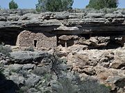 Cliff dwellings of the Sinagua people.
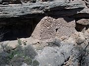 Close up view of the cliff dwellings of the Sinagua people.
 Diorama showing how the pre-Columbian Sinagua people may have lived in Montezuma Castle,
 Sinagua pithouse, from 1050 CE. Two largest holes in the dirt floor held the timber roof supports. The holes around the edge reveal the outline of the structure.
 Ruins of a Sinagua house.
 Historic view of the Sinagua cliff dwelling at Montezuma Castle National Monument, 1887


