Related Research Articles
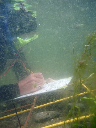
Underwater archaeology is archaeology practiced underwater. As with all other branches of archaeology, it evolved from its roots in pre-history and in the classical era to include sites from the historical and industrial eras. Its acceptance has been a relatively late development due to the difficulties of accessing and working underwater sites, and because the application of archaeology to underwater sites initially emerged from the skills and tools developed by shipwreck salvagers. As a result, underwater archaeology initially struggled to establish itself as actual archaeological research. This changed when universities began teaching the subject and a theoretical and practical base for the sub-discipline was firmly established in the late 1980s. Underwater archaeology now has a number of branches including, maritime archaeology: the scientifically based study of past human life, behaviours and cultures and their activities in, on, around and (lately) under the sea, estuaries and rivers. This is most often effected using the physical remains found in, around or under salt or fresh water or buried beneath water-logged sediment. In recent years, the study of submerged WWII sites and of submerged aircraft in the form of underwater aviation archaeology have also emerged as bona fide activity.

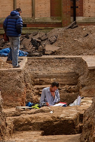
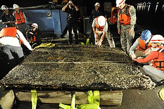
In archaeology, excavation is the exposure, processing and recording of archaeological remains. An excavation site or "dig" is the area being studied. These locations range from one to several areas at a time during a project and can be conducted over a few weeks to several years.

An archaeological site is a place in which evidence of past activity is preserved, and which has been, or may be, investigated using the discipline of archaeology and represents a part of the archaeological record. Sites may range from those with few or no remains visible above ground, to buildings and other structures still in use.
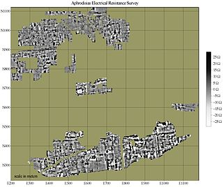
In archaeology, geophysical survey is ground-based physical sensing techniques used for archaeological imaging or mapping. Remote sensing and marine surveys are also used in archaeology, but are generally considered separate disciplines. Other terms, such as "geophysical prospection" and "archaeological geophysics" are generally synonymous.
Umm el-Marra,, east of modern Aleppo in the Jabbul Plain of northern Syria, was one of the ancient Near East's oldest cities, located on a crossroads of two trade routes northwest of Ebla, in a landscape that was much more fertile than it is today. Possibly this is the city of Tuba mentioned in Egyptian inscriptions listing cities that were defeated or destroyed in the Pharaoh Thutmose III's north Syrian campaign. The city of Tuba is also mentioned in epigraphic remains from Ebla, Mari, and Alalakh.

The law of superposition is an axiom that forms one of the bases of the sciences of geology, archaeology, and other fields pertaining to geological stratigraphy. In its plainest form, it states that in undeformed stratigraphic sequences, the oldest strata will lie at the bottom of the sequence, while newer material stacks upon the surface to form new deposits over time. This is paramount to stratigraphic dating, which requires a set of assumptions, including that the law of superposition holds true and that an object cannot be older than the materials of which it is composed. To illustrate the practical applications of superposition in scientific inquiry, sedimentary rock that has not been deformed by more than 90° will exhibit the oldest layers on the bottom, thus enabling paleontologists and paleobotanists to identify the relative ages of any fossils found within the strata, with the remains of the most archaic lifeforms confined to the lowest. These findings can inform the community on the fossil record covering the relevant strata, to determine which species coexisted temporally and which species existed successively in perhaps an evolutionarily or phylogenetically relevant way.

In archaeological excavation, a feature is a collection of one or more contexts representing some human non-portable activity, such as a hearth or wall. Features serve as an indication that the area in which they are found has been interfered with in the past, usually by humans.

Trial trenching is a rapid and relatively inexpensive method of archaeological evaluation used to estimate the archaeological potential of a site.
Aerial archaeology is the study of archaeological remains by examining them from a higher altitude. In present day, this is usually achieved by satellite images or through the use of drones.
Urban archaeology is a sub discipline of archaeology specializing in the material past of towns and cities where long-term human habitation has often left a rich record of the past. In modern times, when someone talks about living in a city, they are in an area with many surrounding people and buildings, generally quite tall ones. In archaeological terms, cities give great information because of the infrastructure they have and amounts of people that were around one another. Through the years there has been one big method used for Urban archaeology along with significant historic developments.

Stratigraphy is a key concept to modern archaeological theory and practice. Modern excavation techniques are based on stratigraphic principles. The concept derives from the geological use of the idea that sedimentation takes place according to uniform principles. When archaeological finds are below the surface of the ground, the identification of the context of each find is vital in enabling the archaeologist to draw conclusions about the site and about the nature and date of its occupation. It is the archaeologist's role to attempt to discover what contexts exist and how they came to be created. Archaeological stratification or sequence is the dynamic superimposition of single units of stratigraphy, or contexts.

In archaeology, survey or field survey is a type of field research by which archaeologists search for archaeological sites and collect information about the location, distribution and organization of past human cultures across a large area. Archaeologists conduct surveys to search for particular archaeological sites or kinds of sites, to detect patterns in the distribution of material culture over regions, to make generalizations or test hypotheses about past cultures, and to assess the risks that development projects will have adverse impacts on archaeological heritage. The surveys may be: (a) intrusive or non-intrusive, depending on the needs of the survey team and; (b) extensive or intensive, depending on the types of research questions being asked of the landscape in question. Surveys can be a practical way to decide whether or not to carry out an excavation, but may also be ends in themselves, as they produce important information about past human activities in a regional context.

Relative dating is the science of determining the relative order of past events, without necessarily determining their absolute age. In geology, rock or superficial deposits, fossils and lithologies can be used to correlate one stratigraphic column with another. Prior to the discovery of radiometric dating in the early 20th century, which provided a means of absolute dating, archaeologists and geologists used relative dating to determine ages of materials. Though relative dating can only determine the sequential order in which a series of events occurred, not when they occurred, it remains a useful technique. Relative dating by biostratigraphy is the preferred method in paleontology and is, in some respects, more accurate. The Law of Superposition, which states that older layers will be deeper in a site than more recent layers, was the summary outcome of 'relative dating' as observed in geology from the 17th century to the early 20th century.
A line chart or line graph, also known as curve chart, is a type of chart which displays information as a series of data points called 'markers' connected by straight line segments. It is a basic type of chart common in many fields. It is similar to a scatter plot except that the measurement points are ordered and joined with straight line segments. A line chart is often used to visualize a trend in data over intervals of time – a time series – thus the line is often drawn chronologically. In these cases they are known as run charts.
In archaeology a fill is the material that has accumulated or has been deposited into a cut feature such as ditch or pit of some kind of a later date than the feature itself. Fills are an important part of the archaeological record as their formation and composition can throw light on many aspects of archaeological study.
Conflict archaeology is a sub-discipline within archaeology focused on intergroup and intragroup conflict. Closely linked to battlefield archaeology and Military Sites Archaeology, conflict archaeology is developing as an umbrella sub-discipline that encompasses these others, allowing for greater epistemological elasticity than other terms. Modern conflict archaeology deals with technological, social, cultural, psychological aspects of present conflicts. Unlike battlefield archaeology, modern conflict archaeology delves deeper into the anthropological study of the conflicts rather than the physical manifestations of the battles. As stated by Nicholas Saunders in his book entitled Beyond the Dead Horizon, "These complexities are generated partly by nature of modern wars/conflicts of industrialized intensity and they incorporate political and nationalistic motivations and notions of ethnicity and identity."

Mundigak is an archaeological site in Kandahar province in Afghanistan. During the Bronze Age, it was a center of the Helmand culture. It is situated approximately 55 km (34 mi) northwest of Kandahar near Shāh Maqsūd, on the upper drainage of the Kushk-i Nakhud River.
Tell Ezou is a prehistoric, Neolithic tell, about 2 hectares (220,000 sq ft) in size, located between Krak des Chevaliers and Homs, in Syria.
The archaeological site near the village of Breitenbach in Saxony-Anhalt, Germany is an important open-air settlement that dates to the period of initial colonization of Europe by anatomically modern humans. The occupations date to the early Upper Palaeolithic and more specifically belong to the Aurignacian cultural complex. Breitenbach is currently the biggest open-air settlement site in western Eurasia dating to this time period. Overlying the Palaleolithic deposits are the remains of a younger settlement that has been dated to the Neolithic.
Digital archaeology is the application of information technology and digital media to archaeology. It includes the use of digital photography, 3D reconstruction, virtual reality, and geographical information systems, among other techniques. Computational archaeology, which covers computer-based analytical methods, can be considered a subfield of digital archaeology, as can virtual archaeology.
References
| | This article relating to archaeology is a stub. You can help Wikipedia by expanding it. |