South is one of the cardinal directions or compass points. The direction is the opposite of north and is perpendicular to both west and east.
South is one of the cardinal directions or compass points. The direction is the opposite of north and is perpendicular to both west and east.
The word south comes from Old English sūþ, from earlier Proto-Germanic *sunþaz ("south"), possibly related to the same Proto-Indo-European root that the word sun derived from. Some languages describe south in the same way, from the fact that it is the direction of the sun at noon (in the Northern Hemisphere), [1] like Latin meridies 'noon, south' (from medius 'middle' + dies 'day', cf English meridional), while others describe south as the right-hand side of the rising sun, like Biblical Hebrew תֵּימָן teiman 'south' from יָמִין yamin 'right', Aramaic תַּימנַא taymna from יָמִין yamin 'right' and Syriac ܬܰܝܡܢܳܐ taymna from ܝܰܡܝܺܢܳܐ yamina (hence the name of Yemen, the land to the south/right of the Levant [2] ).
South is sometimes abbreviated as S.

By convention, the bottom or down-facing side of a map is south, although reversed maps exist that defy this convention. [3] To go south using a compass for navigation, set a bearing or azimuth of 180°. Alternatively, in the Northern Hemisphere outside the tropics, the Sun will be roughly in the south at midday. [4]
True south is one end of the axis about which the Earth rotates, called the South Pole. The South Pole is located in Antarctica. Magnetic south is the direction towards the south magnetic pole, some distance away from the south geographic pole. [5]
Roald Amundsen, from Norway, was the first person to reach the South Pole, on 14 December 1911, after Ernest Shackleton from the UK was forced to turn back some distance short. [6]
The Global South refers to the socially and economically less-developed southern half of the globe. 95% of the Global North has enough food and shelter, and a functioning education system. [7] In the South, on the other hand, only 5% of the population has enough food and shelter. It "lacks appropriate technology, it has no political stability, the economies are disarticulated, and their foreign exchange earnings depend on primary product exports". [7]
Use of the term "South" may also be country-relative, particularly in cases of noticeable economic or cultural divide. For example, the Southern United States, separated from the Northeastern United States by the Mason–Dixon line, or the South of England, which is politically and economically unmatched with all of the North of England.
Southern Cone is the name that is often referred to as the southernmost area of South America that, in the form of an inverted "cone", almost like a large peninsula, encompasses Argentina, Chile, Paraguay, Uruguay and the entire South of Brazil (Brazilian states of Rio Grande do Sul, Santa Catarina, Paraná and São Paulo). Rarely does the meaning broaden to Bolivia, and in the most restricted sense it only covers Chile, Argentina and Uruguay.
The country of South Africa is so named because of its location at the southern tip of Africa. Upon formation the country was named the Union of South Africa in English, reflecting its origin from the unification of four formerly separate British colonies. Australia derives its name from the Latin Terra Australis ("Southern Land"), a name used for a hypothetical continent in the Southern Hemisphere since ancient times.
In the card game bridge, one of the players is known for scoring purposes as South. South partners with North and plays against East and West. [8]
In Greek religion, Notos, was the south wind and bringer of the storms of late summer and autumn.

Body relative directions are geometrical orientations relative to a body such as a human person's body. The most common ones are: left and right; forward(s) and backward(s); up and down. They form three pairs of orthogonal axes.

Navigation is a field of study that focuses on the process of monitoring and controlling the movement of a craft or vehicle from one place to another. The field of navigation includes four general categories: land navigation, marine navigation, aeronautic navigation, and space navigation.
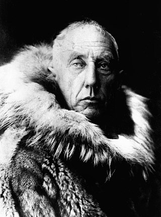
Roald Engelbregt Gravning Amundsen was a Norwegian explorer of polar regions. He was a key figure of the period known as the Heroic Age of Antarctic Exploration.

A compass is a device that shows the cardinal directions used for navigation and geographic orientation. It commonly consists of a magnetized needle or other element, such as a compass card or compass rose, which can pivot to align itself with magnetic north. Other methods may be used, including gyroscopes, magnetometers, and GPS receivers.

North is one of the four compass points or cardinal directions. It is the opposite of south and is perpendicular to east and west. North is a noun, adjective, or adverb indicating direction or geography.
East is one of the four cardinal directions or points of the compass. It is the opposite direction from west and is the direction from which the Sun rises on the Earth.

A sundial is a horological device that tells the time of day when direct sunlight shines by the apparent position of the Sun in the sky. In the narrowest sense of the word, it consists of a flat plate and a gnomon, which casts a shadow onto the dial. As the Sun appears to move through the sky, the shadow aligns with different hour-lines, which are marked on the dial to indicate the time of day. The style is the time-telling edge of the gnomon, though a single point or nodus may be used. The gnomon casts a broad shadow; the shadow of the style shows the time. The gnomon may be a rod, wire, or elaborately decorated metal casting. The style must be parallel to the axis of the Earth's rotation for the sundial to be accurate throughout the year. The style's angle from horizontal is equal to the sundial's geographical latitude.

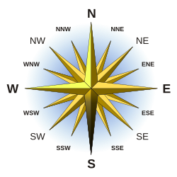
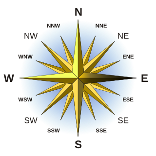
The four cardinal directions, or cardinal points, are the four main compass directions: north, south, east, and west, commonly denoted by their initials N, S, E, and W respectively. Relative to north, the directions east, south, and west are at 90 degree intervals in the clockwise direction.
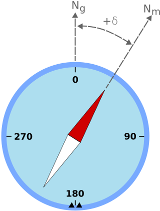
Magnetic declination is the angle between magnetic north and true north at a particular location on the Earth's surface. The angle can change over time due to polar wandering.

A compass rose, sometimes called a wind rose, rose of the winds or compass star, is a figure on a compass, map, nautical chart, or monument used to display the orientation of the cardinal directions and their intermediate points. It is also the term for the graduated markings found on the traditional magnetic compass. Today, a form of compass rose is found on, or featured in, almost all navigation systems, including nautical charts, non-directional beacons (NDB), VHF omnidirectional range (VOR) systems, global-positioning systems (GPS), and similar equipment.
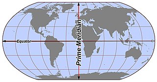
In geography and geodesy, a meridian is the locus connecting points of equal longitude, which is the angle east or west of a given prime meridian. In other words, it is a line of longitude. The position of a point along the meridian is given by that longitude and its latitude, measured in angular degrees north or south of the Equator. On a Mercator projection or on a Gall-Peters projection, each meridian is perpendicular to all circles of latitude. A meridian is half of a great circle on Earth's surface. The length of a meridian on a modern ellipsoid model of Earth has been estimated as 20,003.93 km (12,429.87 mi).

The Axel Heiberg Glacier in Antarctica is a valley glacier, 30 nautical miles long, descending from the high elevations of the Antarctic Plateau into the Ross Ice Shelf between the Herbert Range and Mount Don Pedro Christophersen in the Queen Maud Mountains.

Helmer Julius Hanssen was a Norwegian sailor, pilot and polar explorer. He participated in three of the polar expeditions led by Roald Amundsen and was one of the first five explorers to reach the South Pole.

Polheim was Roald Amundsen's name for his camp at the South Pole. He arrived there on 14 December 1911, along with four other members of his expedition: Helmer Hanssen, Olav Bjaaland, Oscar Wisting, and Sverre Hassel.

Diver navigation, termed "underwater navigation" by scuba divers, is a set of techniques—including observing natural features, the use of a compass, and surface observations—that divers use to navigate underwater. Free-divers do not spend enough time underwater for navigation to be important, and surface supplied divers are limited in the distance they can travel by the length of their umbilicals and are usually directed from the surface control point. On those occasions when they need to navigate they can use the same methods used by scuba divers.

Magnetic dip, dip angle, or magnetic inclination is the angle made with the horizontal by Earth's magnetic field lines. This angle varies at different points on Earth's surface. Positive values of inclination indicate that the magnetic field of Earth is pointing downward, into Earth, at the point of measurement, and negative values indicate that it is pointing upward. The dip angle is in principle the angle made by the needle of a vertically held compass, though in practice ordinary compass needles may be weighted against dip or may be unable to move freely in the correct plane. The value can be measured more reliably with a special instrument typically known as a dip circle.

Sun path, sometimes also called day arc, refers to the daily and seasonal arc-like path that the Sun appears to follow across the sky as the Earth rotates and orbits the Sun. The Sun's path affects the length of daytime experienced and amount of daylight received along a certain latitude during a given season.

The South Pole, also known as the Geographic South Pole, Terrestrial South Pole or 90th Parallel South, is the southernmost point on Earth and lies antipodally on the opposite side of Earth from the North Pole, at a distance of 20,004 km in all directions. It is one of the two points where Earth's axis of rotation intersects its surface.

The north magnetic pole, also known as the magnetic north pole, is a point on the surface of Earth's Northern Hemisphere at which the planet's magnetic field points vertically downward. There is only one location where this occurs, near the geographic north pole. The geomagnetic north pole is the northern antipodal pole of an ideal dipole model of the Earth's magnetic field, which is the most closely fitting model of Earth's actual magnetic field.
Direction determination refers to the ways in which a cardinal direction or compass point can be determined in navigation and wayfinding. The most direct method is using a compass, but indirect methods exist, based on the Sun path, the stars, and satellite navigation.