Development of the Hellenic orogeny
The original proponent of a convergent boundary between Africa and Eurasia, who devised Tethys Ocean and Gondwana land for the purpose, and invented the -ides suffix, Eduard Suess, imagined a single great closure of Gondwana land on Eurasia, wrinkling up a mountain belt, the Altaides, that stretched from sea to sea. The simplicity and the name did not survive further scrutiny of the rocks. The mountain chain, subsequently the non-Suessian Alpides (he had his own Alpides, which amounted to the western Altaides), turned out to be the accumulation of orogenies in successive waves of advance. Not all the parallel chains derive from the same period or the same rocks. From the present, there is a virtual advance with a virtual resulting chain, but the chain is mainly a composite of successive chains.
The mountains of Greece, or Hellenides (viewed as a singular collective thing) appear to have had a singular origin, superficially named "the Hellenic orogeny". These are only terms of convenience to distinguish "Hellenic" from the mountains of other countries. They are accumulated mountain chains resulting from accumulated orogenies over time. Currently, three "waves", of orogenic activity can be distinguished, resulting in three "orogenic belts". [1]
Preceding the first wave, the supercontinent, Pangaea, had already broken into Laurasia (a continuous band of Eurasia and the Americas), and Gondwana (all the rest). Between the two of them was Paleo-Tethys Ocean. The break-up had been caused by shifting currents in the mantle. A different location of an upwelling plume placed a divergent boundary in a new place, in this case across the north and east of Gondwana.
The Cimmeria terrane began to separate from Gondwana, closing Palaeo-Tethys in front of it and opening Neo-Tethys, or just plain Tethys, behind it. Cimmeria voyaged across the ocean to lodge against Eurasia, forming Cimmeria-Eurasia. The existing Cimmerides (named after the mountains of Crimea) account for the northernmost chains of the Alpides. Sometimes they are called the Hunic terranes, after the land of the Huns. They cover the Black Sea region, the northern Aegean, and the eastern part of the Balkans. Their earliest date is the "pre-Late Jurassic". [2]
Subsequent is a two-phase Alpine Orogeny. In phase 1 (Cretaceous) the Tethys sea floor after depositing its Cimmerian passenger against Eurasia went on to dip beneath Cimmeria-Eurasia raising the inner (eastern) Hellenides (Pindus range) and the Anatolides. Phase 2 is the arrival of another terrane, the Adriatic, or Apulian, Plate from the southwest, dipping under Cimmeria-Eurasia and raising its margin into the Dinarides and outer Hellenides in the Eocene and Oligocene.
The geologic stage was set for the latest orogenic zone, developing in the Miocene and Pliocene. It is customary to regard Tethys as gone, replaced by the Mesogean sea, plate, and orogeny, which were transitional to the Mediterranean. The Mesogean Plate is of Gondwana; that is, the predecessor of the African Plate. This plate, moving north as Gondwana approached the Alpine-Cimmerian-Eurasian Plate, dove under it in the ancestor of the Hellenic Trench. The result was the raising of the forearc and the "exhumation" of Peloponnesus and Crete. It began to migrate to the south by back-arc extension, jutting out into the Mesogean Sea and becoming arcuate. From there the geologic story becomes more familiar, being mentioned above. [3]
The Quaternary in the Aegean has been a time of faulting to adjust to the current pressures. In the Pliocene, the extension had been NE–SW causing "normal high angle faults trending NW–SE". [4] In the Quaternary, the direction of extension changed to N-S with faults trending E–W. The type is predominantly strike-slip.

The Alps form part of a Cenozoic orogenic belt of mountain chains, called the Alpide belt, that stretches through southern Europe and Asia from the Atlantic all the way to the Himalayas. This belt of mountain chains was formed during the Alpine orogeny. A gap in these mountain chains in central Europe separates the Alps from the Carpathians to the east. Orogeny took place continuously and tectonic subsidence has produced the gaps in between.

The Tethys OceanTEETH-iss, TETH-, also called the Tethys Sea or the Neo-Tethys, was a prehistoric ocean during much of the Mesozoic Era and early Cenozoic Era, located between the ancient continents of Gondwana and Laurasia, before the opening of the Indian and Atlantic oceans during the Cretaceous Period.

The Alpine orogeny or Alpide orogeny is an orogenic phase in the Late Mesozoic (Eoalpine) and the current Cenozoic that has formed the mountain ranges of the Alpide belt.

The islands of Japan are primarily the result of several large ocean movements occurring over hundreds of millions of years from the mid-Silurian to the Pleistocene, as a result of the subduction of the Philippine Sea Plate beneath the continental Amurian Plate and Okinawa Plate to the south, and subduction of the Pacific Plate under the Okhotsk Plate to the north.

The Caledonian orogeny was a mountain-building cycle recorded in the northern parts of the British Isles, the Scandinavian Caledonides, Svalbard, eastern Greenland and parts of north-central Europe. The Caledonian orogeny encompasses events that occurred from the Ordovician to Early Devonian, roughly 490–390 million years ago (Ma). It was caused by the closure of the Iapetus Ocean when the Laurentia and Baltica continents and the Avalonia microcontinent collided.

The Alpide belt or Alpine-Himalayan orogenic belt, or more recently and rarely the Tethyan orogenic belt, is a seismic and orogenic belt that includes an array of mountain ranges extending for more than 15,000 kilometres (9,300 mi) along the southern margin of Eurasia, stretching from Java and Sumatra, through the Indochinese Peninsula, the Himalayas and Transhimalayas, the mountains of Iran, Caucasus, Anatolia, the Mediterranean, and out into the Atlantic.

The Pleistos is a river in central Greece. It drains the Pleistos valley, named after it, a relatively recent rift valley north of the Gulf of Corinth, and parallel to it. They have the same geologic causes. Being situated in karst topography, much of the river runs or seeps through underground channels. The surface stream is intermittent. However, the limestone riverbed reflecting the light gives the appearance of a stream of water.

The geology of Turkey is the product of a wide variety of tectonic processes that have shaped Anatolia over millions of years, a process which continues today as evidenced by frequent earthquakes and occasional volcanic eruptions.
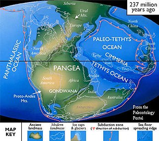
Cimmeria was an ancient continent, or, rather, a string of microcontinents or terranes, that rifted from Gondwana in the Southern Hemisphere and was accreted to Eurasia in the Northern Hemisphere. It consisted of parts of present-day Turkey, Iran, Afghanistan, Pakistan, Tibet, China, Myanmar, Thailand, and Malaysia. Cimmeria rifted from the Gondwanan shores of the Paleo-Tethys Ocean during the Early Permian and as the Neo-Tethys Ocean opened behind it, during the Permian, the Paleo-Tethys closed in front of it. Because the different chunks of Cimmeria drifted northward at different rates, a Meso-Tethys Ocean formed between the different fragments during the Cisuralian. Cimmeria rifted off Gondwana from east to west, from Australia to the eastern Mediterranean. It stretched across several latitudes and spanned a wide range of climatic zones.
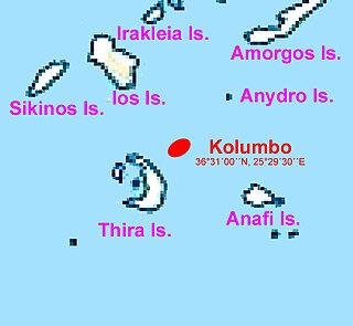
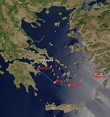
Kolumbo is an active submarine volcano in the Aegean Sea in Greece, about 8 km northeast of Cape Kolumbo, Santorini island. The largest of a line of about twenty submarine volcanic cones extending to the northeast from Santorini, it is about 3 km in diameter with a crater 1.5 km across. It first noticed by humans when it breached the sea surface in 1649-50. The Smithsonian Institution's Global Volcanism Program treats it as part of the Santorini volcano, though at least one source maintains that it is a separate magmatic system.

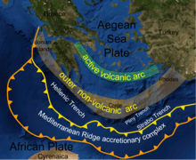
The Aegean Sea Plate is a small tectonic plate located in the eastern Mediterranean Sea under southern Greece and western Turkey. Its southern edge is the Hellenic subduction zone south of Crete, where the African Plate is being swept under the Aegean Sea Plate. Its northern margin is a divergent boundary with the Eurasian Plate.

The geology of New Zealand is noted for its volcanic activity, earthquakes and geothermal areas because of its position on the boundary of the Australian Plate and Pacific Plates. New Zealand is part of Zealandia, a microcontinent nearly half the size of Australia that broke away from the Gondwanan supercontinent about 83 million years ago. New Zealand's early separation from other landmasses and subsequent evolution have created a unique fossil record and modern ecology.
This is a list of articles related to plate tectonics and tectonic plates.

The Hellenic Trench (HT) is an oceanic trough located in the forearc of the Hellenic Arc, an arcuate archipelago on the southern margin of the Aegean Sea Plate, or Aegean Plate, also called Aegea, the basement of the Aegean Sea. The HT begins in the Ionian Sea near the mouth of the Gulf of Corinth and curves to the south, following the margin of the Aegean Sea. It passes close to the south shore of Crete and ends near the island of Rhodes just offshore Anatolia.
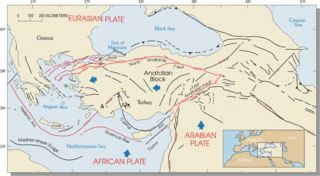
The Hellenic arc or Aegean arc is an arcuate mountain chain of the southern Aegean Sea located on the southern margin of the Aegean Sea Plate. Geologically it results from the subduction of the African Plate under it along the Hellenic subduction zone. The Hellenic Trench trends parallel to its southern side. The Aegean Sea Plate, a microplate, is often considered part of the Eurasian Plate from which it is in the process of diverging. The arc itself is mainly marine, the mountaintops appearing as islands in the Ionian Sea, Crete and its environs, or in the Dodecanese group. It encroaches on mainland terrain in the Peloponnesus, on Crete, on Rhodes, and on the southern coast of Anatolia, thus being encompassed by both Greece and Turkey.

Santorini caldera is a large, mostly submerged caldera, located in the southern Aegean Sea, 120 kilometers north of Crete in Greece. Visible above water is the circular Santorini island group, consisting of Santorini, the main island, Therasia and Aspronisi at the periphery, and the Kameni islands at the center. It has been designated a Decade Volcano.

The main points that are discussed in the geology of Iran include the study of the geological and structural units or zones; stratigraphy; magmatism and igneous rocks; ophiolite series and ultramafic rocks; and orogenic events in Iran.
The geology of Austria consists of Precambrian rocks and minerals together with younger marine sedimentary rocks uplifted by the Alpine orogeny.

The geology of Italy includes mountain ranges such as the Alps and the Apennines formed from the uplift of igneous and primarily marine sedimentary rocks all formed since the Paleozoic. Some active volcanoes are located in Insular Italy.
The Hellenic orogeny is a collective noun referring to multiple mountain building events that shaped the topography of the southern margin of Eurasia into what is now Greece, the Aegean Sea and western Turkey, beginning in the Jurassic. Prior to then the supercontinent, Pangaea, had divided along a divergent boundary into two continents, Gondwana land and Laurasia, separated by a primordial ocean, Paleo-Tethys Ocean. As the two continents continued to break up, Gondwana, pushed by divergent boundaries developing elsewhere, began to drift to the north, closing the sea. As it went it split off a number of smaller land masses, terranes, which preceded it to the north. The Hellenic orogeny is the story of the collision first of these terranes and then of Gondwana, reduced to Africa, with Eurasia, and the closing of Tethys to the Mediterranean. The process has been ongoing since the Jurassic and continues today.