South Hampshire

Last updated
Hampshire UK location map.svg
Location of the boroughs of South Hampshire

Population density map South Hampshire population density map, 2011 census.png
Population density map

South Hampshire is a term used mainly to refer to the conurbation formed by the city of Portsmouth, city of Southampton and the non-metropolitan boroughs of Gosport, Fareham, Havant and Eastleigh in southern Hampshire, South East England. The area was estimated to have a population of over 1.5 million in 2013. [1] It is the most populated part of South East England excluding London. The area is sometimes referred to as Solent City particularly in relation to local devolution, [2] but the term is controversial. [3] [4]

Contents

History

Harold Wilson's Labour government commissioned town planner Colin Buchanan in 1965 to study the region. He found a region of growing economic importance, in desperate need of proper planning to avoid unplanned sprawl, and suggested the construction of a modernist urban area between Southampton and Portsmouth. [5] However this was resisted by local authorities who occupied the proposed development sites, and Buchanan's plans were never put into effect. [1]

Instead, as a result of high-tech industry and services, the area was able to grow largely without overall planning to become perhaps the most densely populated region of the UK. [1] In the late 20th century mass manufacturing of ordinary commodities declined, leaving several town and city neighbourhoods impoverished and suffering unemployment; however by the early 21st century high income and retirement properties came to dominate some neighbourhoods, particularly close to universities, and many suburbs and exurbs. Centrally planned building programmes included large estates, connected by new road networks, for commercial and residential use by Hampshire County Council's architects, led by Colin Stansfield Smith. Otherwise development has tended to be on a case-by-case basis for retail parks, business parks and housing. [1]

The Solent Local Enterprise Partnership (LEP) is a collaboration between local authorities, universities and businesses set up in 2011 by the Department for Business, Innovation and Skills. [6] [7] Different departments of the Solent LEP are distributed across the area, with its 'Growth Hub' being based in Southampton. [8] On 12 November 2013 the government announced the second wave of City Deals, with a successful joint bid of Southampton and Portsmouth providing £953 million of investment into the Solent LEP. [9]

Various attempts at a South Hampshire or Solent City devolution deal have been made, but saw minor local resistance, stemming from the Southampton-Portsmouth rivalry, as well as from the more rural Isle of Wight. [10] [11] Whilst the proposal did otherwise see continued support, particularly from councillors, [12] by 2018 talks with the government had stalled. [10] [13] More recent proposals have included southeast Dorset, that is Bournemouth, Christchurch and Poole (BCP). After another bid was submitted in 2021, Gerald Vernon-Jackson claimed the government were "keen" on including BCP in a potential deal. [14] A November 2022 report by BCP Council suggested a Central South deal as an alternative to a Pan-Hampshire deal with BCP tacked on. [15]

Geography

Southampton-CivicCentre-West.jpg
Spinnaker Tower October 2016.jpg
Southampton and Portsmouth are the largest urban centres of South Hampshire

The region can be subdivided into two conurbations, one centred around Southampton and one around Portsmouth. Most of the area is in the Hampshire districts of Gosport, Fareham, Havant, Eastleigh, Portsmouth and Southampton. All of these districts have high population densities, with Portsmouth and Southampton being the most densely populated districts in England outside Greater London. [16] Other parts of the area are in the Test Valley, East Hampshire, City of Winchester and New Forest districts, all of which have lower population densities. Small parts of the area are also in the West Sussex district of Chichester.

Climate

The climate is temperate oceanic, Cfb in the Köppen climate classification.

Climate data for Southampton, elevation 3 m, 1981–2010
MonthJanFebMarAprMayJunJulAugSepOctNovDecYear
Mean daily maximum °C (°F)8.4
(47.1)
8.6
(47.5)
11.1
(52.0)
14.0
(57.2)
17.5
(63.5)
20.2
(68.4)
22.4
(72.3)
22.3
(72.1)
19.8
(67.6)
15.6
(60.1)
11.7
(53.1)
8.9
(48.0)
15.1
(59.2)
Mean daily minimum °C (°F)2.9
(37.2)
2.6
(36.7)
4.1
(39.4)
5.7
(42.3)
9.0
(48.2)
11.7
(53.1)
13.7
(56.7)
13.7
(56.7)
11.4
(52.5)
8.9
(48.0)
5.4
(41.7)
3.2
(37.8)
7.7
(45.9)
Average rainfall mm (inches)81.4
(3.20)
58.3
(2.30)
60.0
(2.36)
50.7
(2.00)
49.0
(1.93)
50.4
(1.98)
42.0
(1.65)
50.4
(1.98)
60.4
(2.38)
93.8
(3.69)
94.0
(3.70)
89.2
(3.51)
779.4
(30.69)
Average rainy days (≥ 1.0 mm)12.29.210.18.88.27.77.47.78.711.511.511.8114.7
Mean monthly sunshine hours 63.384.4118.3179.8212.1211.2221.8207.7148.1113.076.652.91,689.3
Source 1: Met Office (normals) [17]
Source 2: Calculated from Met Office Data [18]
Climate data for Southsea, Portsmouth 1976-2006
MonthJanFebMarAprMayJunJulAugSepOctNovDecYear
Mean daily maximum °C (°F)9.6
(49.3)
8.8
(47.8)
10.6
(51.1)
13.4
(56.1)
16.8
(62.2)
19.4
(66.9)
21.8
(71.2)
21.8
(71.2)
19.3
(66.7)
15.8
(60.4)
12.0
(53.6)
10.0
(50.0)
14.9
(58.9)
Mean daily minimum °C (°F)5.1
(41.2)
4.3
(39.7)
5.4
(41.7)
6.4
(43.5)
9.6
(49.3)
12.3
(54.1)
15.0
(59.0)
15.0
(59.0)
12.8
(55.0)
10.9
(51.6)
7.5
(45.5)
5.9
(42.6)
9.2
(48.5)
Average precipitation mm (inches)65
(2.6)
50
(2.0)
52
(2.0)
42
(1.7)
28
(1.1)
40
(1.6)
32
(1.3)
43
(1.7)
62
(2.4)
81
(3.2)
72
(2.8)
80
(3.1)
647
(25.5)
Average rainy days11.29.58.37.66.57.45.46.68.510.910.311.2103.4
Mean monthly sunshine hours 67.989.6132.7200.5240.8247.6261.8240.7172.9121.882.360.51,919.1
Percent possible sunshine 26313649515154544637312541
Source: Met Office [19]
Climate data for a Rough climate of Havant
MonthJanFebMarAprMayJunJulAugSepOctNovDecYear
Record high °C (°F)17
(63)
16
(61)
21
(70)
25
(77)
32
(90)
36
(97)
35
(95)
37
(99)
34
(93)
27
(81)
18
(64)
16
(61)
37
(99)
Mean daily maximum °C (°F)8
(46)
8
(46)
11
(52)
13
(55)
17
(63)
20
(68)
23
(73)
24
(75)
19
(66)
16
(61)
11
(52)
9
(48)
15
(59)
Mean daily minimum °C (°F)2
(36)
1
(34)
3
(37)
5
(41)
8
(46)
11
(52)
13
(55)
14
(57)
12
(54)
8
(46)
5
(41)
3
(37)
7
(45)
Record low °C (°F)−10
(14)
−9
(16)
−8
(18)
−4
(25)
−1
(30)
2
(36)
5
(41)
6
(43)
0
(32)
−4
(25)
−6
(21)
−8
(18)
−10
(14)
Average precipitation mm (inches)85
(3.3)
60
(2.4)
62
(2.4)
54
(2.1)
50
(2.0)
50
(2.0)
42
(1.7)
57
(2.2)
74
(2.9)
90
(3.5)
85
(3.3)
90
(3.5)
799
(31.3)
Mean monthly sunshine hours 658513020023023525523017012590601,875
Source: Met Office [19]
Climate data for Solent MRSC, (1981–2010 averages).
MonthJanFebMarAprMayJunJulAugSepOctNovDecYear
Mean daily maximum °C (°F)8.2
(46.8)
8.2
(46.8)
10.5
(50.9)
13.2
(55.8)
16.7
(62.1)
19.2
(66.6)
21.4
(70.5)
21.4
(70.5)
19.0
(66.2)
15.5
(59.9)
11.5
(52.7)
8.7
(47.7)
14.5
(58.1)
Mean daily minimum °C (°F)3.4
(38.1)
2.8
(37.0)
4.5
(40.1)
6.1
(43.0)
9.2
(48.6)
12.1
(53.8)
14.2
(57.6)
14.3
(57.7)
12.2
(54.0)
9.6
(49.3)
6.2
(43.2)
3.8
(38.8)
8.2
(46.8)
Average rainfall mm (inches)68.8
(2.71)
49.3
(1.94)
51.6
(2.03)
42.4
(1.67)
43.4
(1.71)
42.0
(1.65)
44.5
(1.75)
50.0
(1.97)
53.7
(2.11)
86.2
(3.39)
83.2
(3.28)
83.9
(3.30)
699
(27.51)
Average precipitation days (≥ 1 mm)11.69.68.38.37.16.97.07.38.710.511.212.2108.6
Source: Met Office Solent MRSC, Thorney Island

Demography

The following Built-up areas fall inside the South Hampshire metropolitan area have a combined population of 1,086,786.

By council boundaries

Map of the districts making up Portsmouth urban area (blue) and Southampton urban area (red) South Hampshire Districts Map.svg
Map of the districts making up Portsmouth urban area (blue) and Southampton urban area (red)

The following populations is those of council boundaries that are considered part of the South Hampshire conurbation.

South Hampshire built-up area

In the 2001 census Portsmouth and Southampton were recorded as being parts of separate urban areas; but by the 2011 census they had merged to become the sixth largest built-up area in England, with a population of 855,569. [20] The new built-up area also merged with smaller urban areas called Locks Heath, Bursledon, Whiteley and Hedge End/Botley in the 2001 census.

Urban subdivision [21] PopulationDistrict
(2001 census) [21] (2011 census) [20]
Portsmouth 187,056238,137 City of Portsmouth
Gosport 69,34871,529 Borough of Gosport
Fareham 56,16042,210 Borough of Fareham
Havant 45,43545,125 Borough of Havant
Lee-on-the-Solent 7,067 Borough of Gosport
Stubbington 13,62814,077 Borough of Fareham
Waterlooville 63,558 Borough of Havant
Total Portsmouth urban area population442,252
Southampton 234,224253,651 City of Southampton
Eastleigh 52,89478,716 Borough of Eastleigh
Bishopstoke 17,282 Borough of Eastleigh
Total Southampton urban area population304,400
Locks Heath & surrounding villages36,45243,359 Borough of Fareham
Bursledon 6,7446,955 Borough of Eastleigh
Whiteley 2,1953,236 Borough of Fareham/City of Winchester
Total Western Wards population45,39153,550
Hedge End 21,17425,117 Borough of Eastleigh
Botley 2,5065,083 Borough of Eastleigh
Total Hedge End/Botley population23,68030,200
Horndean 46,924 East Hampshire/Borough of Havant
Total South Hampshire built-up area population855,569

Notes:

  • Portchester is included under the Portsmouth subdivision in the 2011 census whilst in the 2001 census it was part of the Fareham subdivision.
  • Whiteley is included under the Locks Heath subdivision in the 2011 census.
  • Stubbington and Lee-on-the-Solent formed a separate urban area according to the 2011 census.
  • Bishopstoke and Horton Heath were included as part of the Eastleigh subdivision in the 2011 census.
  • Botley was included as part of the Hedge End subdivision in the 2011 census.
  • The Waterlooville subdivision was split between the Portsmouth subdivision and the Horndean subdivision for the 2011 census.

Other built-up areas

Hampshire UK location map.svg
Location of other built-up areas in Hampshire

There are three other significant urban areas [22] in the area: [23]

Urban subdivision [21] Population

(2001 census) [21]

Population

(2011 census) [20]

District
Ashurst/Netley Marsh 3,1163,212 New Forest District
Totton 27,98628,676 New Forest District
Bartley 2,281 New Forest District
Total Totton built-up area population31,10234,169
Winchester built-up area41,42046,074 City of Winchester
Stubbington built-up area24,644 Borough of Fareham/Borough of Gosport
Hythe built-up area19,59920,201 New Forest District

There are fourteen smaller urban areas also in the region: [23]

Urban area [21] Population

(2001 census) [21] [24]

Population

(2011 census) [20]

District
Colden Common 3,2493,419 City of Winchester
Compton/Otterbourne 2,2612,569 City of Winchester
Denmead 5,7886,107 City of Winchester
Emsworth/Southbourne 18,13918,777 Borough of Havant/Chichester District
Fawley/Blackfield 13,77513,712 New Forest District
Hamble 3,8534,696 Borough of Eastleigh
Hayling Island 14,84215,485 Borough of Havant
Horton Heath 2,223 Borough of Eastleigh
Kings Worthy 4,2924,901 City of Winchester
Marchwood 5,5866,141 New Forest District
Netley 6,1506,338 Borough of Eastleigh
North Baddesley 6,2346,823 Test Valley
Romsey 17,38617,161 Test Valley

Notes:

  • Horton Heath forms part of the South Hampshire built-up area in the 2011 census rather than being a separate area.
  • In the 2011 census the Fawley urban area was renamed the Blackfield built-up area.
  • In the 2011 census the Kings Worthy urban area was renamed the Springvale built-up area.
  • In the 2011 census the Hayling Island urban area was renamed the South Hayling built-up area.

Other towns in the area

Slightly further out there are many satellite towns that may not be directly attached to Southampton or Portsmouth, or necessarily in their travel to work areas, [25] but are nonetheless still heavily reliant on the two cities for employment and services.

Places within the wider Portsmouth-Southampton Metropolitan area include:

Settlement County
Andover [26] Hampshire
Bishop's Waltham [23] [27] Hampshire
Bognor Regis [26] West Sussex
Brockenhurst Hampshire
Chichester West Sussex
Lyndhurst Hampshire
Newport Isle of Wight
Ryde Isle of Wight
Salisbury [26] Wiltshire

See also

Related Research Articles

<span class="mw-page-title-main">Hampshire</span> County of England

Hampshire is a ceremonial county in South East England. It is bordered by Berkshire to the north, Surrey and West Sussex to the east, the Isle of Wight across the Solent to the south, Dorset to the west, and Wiltshire to the north-west. The city of Southampton is the largest settlement, and the county town is the city of Winchester.

<span class="mw-page-title-main">Fareham</span> Market town on Portsmouth Harbour, England

Fareham is a market town at the north-west tip of Portsmouth Harbour, between the cities of Portsmouth and Southampton in south east Hampshire, England. It gives its name to the Borough of Fareham. It was historically an important manufacturer of bricks, used to build the Royal Albert Hall, and grower of strawberries and other seasonal fruits.

<span class="mw-page-title-main">Gosport</span> Coastal town in Hampshire, England

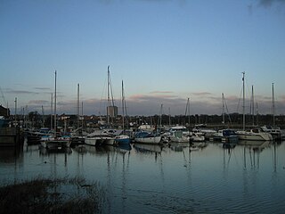
Gosport is a town and non-metropolitan borough, on the south coast of Hampshire, South East England. At the 2021 Census, its population was 81,952. Gosport is situated on a peninsula on the western side of Portsmouth Harbour, opposite the city of Portsmouth, to which it is linked by the Gosport Ferry. Gosport lies south-east of Fareham, to which it is linked by a Bus Rapid Transit route and the A32. Until the last quarter of the 20th century, Gosport was a major naval town associated with the defence and supply infrastructure of His Majesty's Naval Base (HMNB) Portsmouth. As such over the years extensive fortifications were created.

<span class="mw-page-title-main">Portchester</span> Human settlement in England

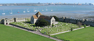
Portchester is a village in the Borough of Fareham in Hampshire, England. It is 4 miles (6.4 km) northwest of Portsmouth and around 18 miles east of Southampton on the A27 road. Its population according to the 2011 United Kingdom census was 17,789.

<span class="mw-page-title-main">Borough of Fareham</span> Non-metropolitan and borough in England

The Borough of Fareham is a local government district with borough status in Hampshire, England. Its council is based in Fareham. Other places within the borough include Portchester, Hill Head, Sarisbury, Stubbington, Titchfield and Warsash. The borough covers much of the semi-urban area between the cities of Southampton and Portsmouth, and is part of the South Hampshire conurbation. The neighbouring districts are Eastleigh, Winchester, Portsmouth and Gosport. The district's southern boundary is the coast of the Solent.

Whiteley is a community of (planned) 6,500 homes in the county of Hampshire, England, near Fareham. The development straddles the boundary between two council districts: the Borough of Fareham to the south and east, and the city of Winchester to the north and west.

<span class="mw-page-title-main">Lee-on-the-Solent</span> Human settlement in England

Lee-on-the-Solent, often referred to as Lee-on-Solent, is a seaside district of the Borough of Gosport in Hampshire, England, about five miles (8 km) west of Portsmouth. The area is located on the coast of the Solent. It is primarily a residential area, with an upsurge of mostly local visitors in summer, but was also the former home to the Royal Naval Air Station HMS Daedalus.

<span class="mw-page-title-main">West Coastway line</span> Railway line in England

The West Coastway line is a railway line in England linking the conurbations of Brighton/Hove/Littlehampton and Southampton/Portsmouth, with 1.3 million people between them. It has short southward branches to Littlehampton and Bognor Regis, which offer direct services to and from London.

<span class="mw-page-title-main">Fareham (UK Parliament constituency)</span> Constituency in southern England

Fareham is a constituency in Hampshire represented in the House of Commons of the UK Parliament. Since 2015, it has been represented by Suella Braverman of the Conservative Party.

<span class="mw-page-title-main">Fareham railway station</span> Railway station in Hampshire, England

Fareham railway station is on the West Coastway Line situated about 0.62 miles (1 km) from the town of Fareham in Hampshire, England. It is 84 miles 21 chains (135.6 km) down the line from London Waterloo.

<span class="mw-page-title-main">First Hampshire & Dorset</span> Bus operator

First Hampshire & Dorset is a bus operator providing services in the counties of Hampshire and Dorset. It is a subsidiary of FirstGroup.

<span class="mw-page-title-main">South East England Development Agency</span>

The South East England Development Agency (SEEDA) was one of a number of regional development agencies in England. It was set up as a non-departmental public body in 1999 to promote the region and to enable a number of more difficult regeneration projects which otherwise might not take place. It covered Berkshire, Buckinghamshire, East Sussex, Hampshire, the Isle of Wight, Kent, Oxfordshire, Surrey and West Sussex

The Southampton–Fareham line is a railway line in England, along the south coast of Hampshire. As a through line it came late in British Railway history, traversing unpromising coastal terrain. The first part from Portswood, near Southampton, to Netley was opened in 1866, prompted by the establishment of the Royal Victoria Hospital at Netley, which had been established for the care of wounded soldiers.

The Gosport and Cosham lines were a collection of railway lines in southern Hampshire. Most of the lines are now closed but some elements are still in use, forming part of the West Coastway line. The lines originally linked to the main London to Southampton line via the Eastleigh–Fareham line and subsequently with a line from Southampton via Bursledon, both of which are still in use.

<span class="mw-page-title-main">Funtley Deviation</span>

The Funtley Deviation was a 2-mile long double track railway opened as a single line in 1904 and as a double line in 1906 to provide an alternative to the 1841 railway line north of Fareham which traversed the precarious Fareham tunnel. Unfortunately the deviation line suffered from stability problems of its own and it was eventually closed on 6 May 1973, in favour of the original route, and is now a nature walk with a small car park at the Highlands Road end. The route south of Highlands Road was sold for housing.

<span class="mw-page-title-main">South Hampshire Lowlands</span>

The South Hampshire Lowlands form a natural landscape in south, central England within the county of Hampshire.

<span class="mw-page-title-main">Grade II* listed buildings in Hampshire</span>

The county of Hampshire is divided into 13 districts. The districts of Hampshire are Gosport, Fareham, Winchester, Havant, East Hampshire, Hart, Rushmoor, Basingstoke and Deane, Test Valley, Eastleigh, New Forest, Southampton, and Portsmouth.

References

  1. 1 2 3 4 Hatherley, Owen (27 February 2013). "How Labour got lost in Eastleigh's unplanned sprawl". The Guardian .
  2. Viccars, Andy (4 August 2003). "Transport Position Statement by Southampton and Fareham Chamber of Commerce and Industry" (PDF). Fareham Borough Council. Retrieved 1 August 2014.
  3. "MP blasts report as a revival of Solent City". Southern Daily Echo . 8 November 1999. Retrieved 1 August 2014.
  4. Fishwick, Ben (11 April 2014). "Residents rally as they fight plan to build 1,550 homes". The News (Portsmouth) . Retrieved 30 November 2018. He said: I do not want to live in "Solent City". I'd rather live in Fareham. I think we should keep the strategic gap.
  5. Phelps, Nicholas (2012). An Anatomy of Sprawl: Planning and Politics in Britain. Routledge. The term Solent City is nowhere to be found in the South Hampshire Study and instead emerged as shorthand for the sheer horror felt by inhabitants and their political representatives over the emergence of a single functional urban region
  6. https://www.gov.uk/government/uploads/system/uploads/attachment_data/file/256460/2013111_Southampton_and_Portsmouth_City_Deal_Document_and_Implementation_Plans.pdf [ bare URL PDF ]
  7. Emma Streatfield (7 October 2015). "Solent Local Enterprise Partnership has put in a bid to create a new enterprise zone near Southampton Airport that could create 6,000 jobs". Southern Daily Echo . Newsquest . Retrieved 7 September 2018.
  8. Ryan Platt (21 August 2017). "#19 Starting a business in Southampton". Startups. Retrieved 7 September 2018.
  9. "Southampton and Portsmouth get City Deal". BBC News. 12 November 2013. Retrieved 23 September 2018.
  10. 1 2 "Coast joint authority plan dropped". BBC News. 30 June 2015. Retrieved 12 April 2020.
  11. "Solent Devolution". Isle of Wight News from OnTheWight. Retrieved 12 April 2020.
  12. "Devolution bid must be 'right for island'". BBC News. 6 October 2018. Retrieved 12 April 2020.
  13. "New Solent authority deal 'scrapped'". BBC News. 5 October 2018. Retrieved 12 April 2020.
  14. "EXCLUSIVE: Devo map finds new deals in sight as negotiations begin". LGC. 7 March 2022. Retrieved 11 April 2023.
  15. "Exploring the options for devolution to BCP Council" (PDF). Cabinet: BCP Council. 23 November 2022. Retrieved 11 April 2023.
  16. "Mid-Year Population Estimates, UK, June 2021". Office for National Statistics. 21 December 2022. Retrieved 18 October 2023.
  17. "Southampton W.C Climate Period: 1981-2010". Met Office. Retrieved 5 February 2013.
  18. "Long Term weather data". Met Office. May 2011. Archived from the original on 20 August 2011. Retrieved 20 March 2011.
  19. 1 2 "Regional mapped climate averages". Met Office. November 2008. Retrieved 8 March 2011.
  20. 1 2 3 4 "2011 Census - Built-up areas". ONS . Retrieved 20 July 2013.
  21. 1 2 3 4 5 6 ONS (2004). Census 2001: Key Statistics for urban areas in England and Wales (PDF). HMSO. ISBN   0-11-621743-X.
  22. ONS (2004). Map showing urban areas (PDF). HMSO.
  23. 1 2 3 Portsmouth-Southampton: largest cities and towns and statistics of their population Shows what is considered part of this metropolitan area
  24. Table KS01 Usual resident population
  25. "Travel to Work Areas". Office for National Statistics . Retrieved 1 August 2014. - see map on website
  26. 1 2 3 "British urban pattern: population data" (PDF). ESPON project 1.4.3 Study on Urban Functions. European Spatial Planning Observation Network. March 2007. p. 119. Archived from the original (PDF) on 24 September 2015. Retrieved 22 February 2010.
  27. "South Hampshire Sub-region map" (PDF). Retrieved 9 May 2012.

50°52′N1°16′W / 50.867°N 1.267°W / 50.867; -1.267