South London originally emerged from Southwark,[1] first recorded as Suthriganaweorc,[2][3] meaning 'fort of the men of Surrey'.[2][3] From Southwark, London then extended further down into northern Surrey and western Kent.
South London began at Southwark[1] at the southern end of London Bridge, the first permanent crossing over the river, with early development of the area being a direct result of the existence and location of the bridge.
South of London in 1800. The border between Surrey and Kent is shown running south from Deptford, through SydenhamThe heads of traitors were displayed on spikes, on the southern gatehouse of London BridgeSt Olaf's House, Southwark. Olaf, later St Olaf, helped the English retake London Bridge from his fellow Norsemen.
The opening of Westminster Bridge and other subsequent bridges to the west encouraged growth in the south-west, but only Tower Bridge was built to the east of London Bridge, so south-east London grew more slowly, at least until the Surrey Commercial Docks were built.
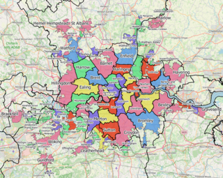
The development of a dense network of railway lines in the mid nineteenth century significantly accelerated growth. The County of London was formed in 1899, which incorporated these boroughs south of the river: Wandsworth, Lambeth, Battersea, Camberwell, Southwark, Bermondsey, Deptford, Lewisham, Greenwich and Woolwich. During the first half of the 20th century, towns in the Home Counties such as Kingston, Croydon and Bromley gradually coalesced with South London, until Greater London was formed in 1965.
Transport
A significant feature of south London's economic geography is that while there are more than thirty bridges linking the area with West London and the City, there is only one, Tower Bridge, linking the area with East London.
Very little of London's underground rail network lies south of the river, largely due to the challenging geology;[4] however, 21st-century technology makes tunnelling much cheaper (though stations are still expensive) and this may lead to an improved underground provision in south London with the Crossrail 2 line proposed alongside extensions to the Northern and Bakerloo Lines.
South London contains an extensive overground rail network[4] and all of London's trams operate within the area.
A small area of land, on which the southern end of Blackfriars Bridge stands, is not part of Southwark. It forms part of the City of London, a sui generis local authority which is mainly located north of the Thames.
Formal use
The term 'south London' has been used for a variety of formal purposes with the boundaries defined according to the purposes of the designation.
Constituency review, 2017
In 2017 the government asked the Boundary Commission for England to reconsider the boundaries of parliamentary constituencies. The commission's study, was to start with existing regions of England and then group the local authorities within that area into sub-regions for further sub-division. The south London sub-region included the 11 boroughs which lay south of the river, plus the parts of cross-river Richmond upon Thames that did so.[6]
An earlier 2013 study, whose recommendations were not adopted, took a different approach by including all of Richmond in its south London sub-region.[7]
Sub-region policy
For the purposes of progress reporting on the London Plan, there was a south London sub-region in operation from 2004 to 2008 consisting of Bromley, Croydon, Kingston, Merton, Richmond and Sutton.[8] In 2001 this area had a population of 1,329,000.[9] This definition is used by organisations such as Connexions.[10]
Between 2008 and 2011 it was replaced with a South East sub-region consisting of Southwark, Lewisham, Greenwich, Bexley and Bromley and a South West sub-region consisting of Croydon, Kingston, Lambeth, Merton, Sutton, Richmond and Wandsworth.[11]
In 2011 a new south London region was created consisting of Bromley, Croydon, the Royal Borough of Kingston upon Thames, Richmond upon Thames, Merton, Sutton, Wandsworth, Bexley, Greenwich and Lewisham.
Climate
South London is, like other parts of London and the UK in general, a temperate maritime climate according to the Köppen climate classification system. Three Met Office weather stations currently collect climate data south of the river; Kew, Hampton and Kenley Airfield, on the southern edge of the urban area.[12] Long term climate observations dating back to 1763[13] are available for Greenwich, although observations ceased here in 2003.
Temperatures increase towards the Thames, firstly because of the urban warming effect of the surrounding area, but secondly due to altitude decreasing towards the river, meaning the southern margins of south London are often a couple of degrees cooler than those areas adjacent to the Thames. Often snow can be seen to lie on the North Downs near Croydon when central London is snow free.
The record high temperature at Greenwich is 37.5°C (99.5°F) recorded during August 2003.[14] Sunshine is notably lower than other London area weather stations (by about 50–100 hours a year), suggesting Greenwich may be a fog trap in winter, and that the hillier land to the south may obscure early morning and late evening sunshine.
The highest temperature recorded across south London was 38.1°C (100.6°F) on the same occasion at Kew Gardens. Although the Met Office accepts a higher reading from Brogdale in Kent, many have questioned the accuracy of this[15] and regard the Kew reading as the most reliable highest UK temperature reading.
London Road is a popular road name in the United Kingdom. Roads called London Road include:
The Diocese of Southwark is one of the 42 dioceses of the Church of England, part of the worldwide Anglican Communion. The diocese forms part of the Province of Canterbury in England. It was created on 1 May 1905 from part of the ancient Diocese of Rochester that was served by a suffragan bishop of Southwark (1891–1905). Before 1877 most of the area was part of the Diocese of Winchester, some being part of the Diocese of London.
The region of Greater London, including the City of London, is divided into 73 parliamentary constituencies which are sub-classified as borough constituencies, affecting the type of electoral officer and level of expenses permitted.
The London Government Act 1963 is an act of the Parliament of the United Kingdom, which created Greater London and a new local government structure within it. The Act significantly reduced the number of local government districts in the area, resulting in local authorities responsible for larger areas and populations. The upper tier of local government was reformed to cover the whole of the Greater London area and with a more strategic role; and the split of functions between upper and lower tiers was recast. The Act classified the boroughs into inner and outer London groups. The City of London and its corporation were essentially unreformed by the legislation. Subsequent amendments to the Act have significantly amended the upper tier arrangements, with the Greater London Council abolished in 1986, and the Greater London Authority introduced in 2000. As of 2016, the London boroughs are more or less identical to those created in 1965, although with some enhanced powers over services such as waste management and education.
The Greater London Built-up Area, or Greater London Urban Area, is a conurbation in south-east England that constitutes the continuous urban sprawl of London, and includes surrounding adjacent urban towns as defined by the Office for National Statistics. It is the largest urban area in the United Kingdom with a population of 9,787,426 in 2011.
Local government elections took place in London, and some other parts of the United Kingdom on Thursday 4 May 2006. Polling stations were open between 7am and 10pm.
The Traffic Operational Command Unit (OCU), formally known as CO15, was the Road Policing Unit for the Metropolitan Police Service in Greater London, England.
The Royal Commission on Local Government in Greater London, also known as the Herbert Commission, was established in 1957 and published its report in 1960. The report made recommendations for the overhaul of the administration of the capital. They were modified and implemented by the London Government Act 1963.
Janani (Jan) Jananayagam is a British Tamil banking professional, activist and politician. She was an independent candidate for the London region in the 2009 European Parliamentary elections.
Greater London Association of Trade Union Councils (GLATUC) is the largest County Association of Trades (Union) Councils in the Uk and covers the Greater London area. As the official Trades Union Congress body for London GLATUC seeks to co-ordinate activity by Trades (Union) Councils across the capital and works with individual unions and other organisations on a range of campaigns and activities. It is part of the national Trades Union Congress.
Local government elections took place in London, and some other parts of the United Kingdom on Thursday 6 May 2010. Polling stations were open between 7am and 10pm.
Local government elections took place in London, and some other parts of the United Kingdom on Thursday 2 May 2002. Ward changes took place in every borough, following a series of reviews and 32 statutory instruments which reduced the total number of councillors by 56 from 1,917 to 1,861.
The 2018 London local elections took place in London on 3 May 2018 as part of wider local elections in England. All London borough councillor seats were up for election. Elections to the Corporation of London were held in 2017. Mayoral contests were also held in Hackney, Lewisham, Newham and Tower Hamlets. The previous London borough elections were in 2014.
1 2 3 Mills, Anthony David (2010). Oxford Dictionary of London Place-Names (2nded.). Oxford University Press. p.231. ISBN9780199566785.
1 2 David J. Johnson. Southwark and the City. Oxford University Press, 1969. p. 7. ISBN978-0-19-711630-2
1 2 Wolmar, Christian (2004). The Subterranean Railway: How the London Underground Was Built and How It Changed the City Forever. Atlantic Books. ISBN978-1-84354-023-6.
This page is based on this Wikipedia article Text is available under the CC BY-SA 4.0 license; additional terms may apply. Images, videos and audio are available under their respective licenses.


