South Norwood Library

Last updated

South Norwood Library
SouthNorwoodLibrary2021.jpg
South Norwood Library
LocationSouth Norwood, London
Type public library
Established1968
Architect(s) Hugh Lea, Dip. Arch. (Leeds) A.R.I.B.A.
Branch ofCroydon Libraries
Collection
Size12,967  OOjs UI icon edit-ltr-progressive.svg
Access and use
Access requirementsNone
Other information
Website www.croydon.gov.uk/libraries-leisure-and-culture/libraries/find-your-library/south-norwood-library

South Norwood Library is a purpose-built public library in South Norwood, South London. Also known locally as 'Brutalist Library' it stands in the London Borough of Croydon and is part of the Croydon Libraries [1] arm of the council. The site on the corner of Selhurst Road and Lawrence Road first had a library built in 1897, which was replaced by the current building in 1966. [2] [3]

Contents

Following a risk of moving the library and demolition of the building in 2019, the library service remains in the purpose-built 1968 library with reduced opening hours and a promise of renovation. [4] [5] [6] The Friends of South Norwood Library campaign for the library service, supported by authors including Alex Wheatle. [7] The Brutalist Library Campaign also worked alongside this campaign, intending to protect the building due to its architectural, historical and social merit. [8]

History

The library was designed by Hugh Lea, Borough Architect for Croydon Council in 1966 [9] together with the Chief Librarian T.E. Callander and opened in 1968. [10] It is locally listed, within the South Norwood conservation area and a national listing application has been made to Historic England. [9]

The community takes great pride in this central landmark of South Norwood, and in 2006 the participatory arts organisation 'Mosaic Art' worked with hundreds of children and community members in the borough to create a Mosaic design which would form a permanent art installation in front of the library. Passers-by can enjoy the mosaic heritage treasure map which contains many clues about the history of the area. [2]

In the year April 2012 to March 2013 the library saw 52,916 visitors, this rose to 74,455 April 2016 to March 2017. [11]

Between 2019 and 2022 the library building was under threat of being demolished as a new purpose built building was developed at the Pump House on nearby Station Road to move into, but in 2022 it was announced that the library would stay at the Brutalist Library on Lawrence Road and be refurbished. [5] [6] This was met with celebration from campaigners. [12]

A 2024 Croydon Libraries consultation proposes to reduce the library service from a statutory dedicated library in it's building to a combined Community Hub (with co-located local services and businesses) along with the neighbouring Samuel Coleridge Taylor Centre. [13]

Architecture

The library is a fine example of 1960s Brutalist architecture and shows the influences of Ludwig Mies van der Rohe in its structural clarity and simplicity. [3]

The frontage features bold black steel letters reading "LIBRARY" in Grotesk font typography [3] on a concrete cuboid above a glass lower part of the building. [14]

The library building is arranged over five open-plan levels, split across the front and rear of the building. The front part of the building has the ground floor entrance level, which houses the reception, and the second floor which houses the children's library (formerly a general reading room). The rear of the building has the basement, first and third floors. The levels are offset so that the floors in the front and rear of the building appear like mezzanine levels to each other. There is a lift serving all five floors. [15] [3]

South Norwood Library has been part of Open House London in 2021, which was organised by the Brutalist Library Campaign, and was featured in the must-see buildings of Open House London alongside 10 Downing Street and City Hall, London (Southwark).

Edwin Heathcote, the Financial Times's architecture critic picked South Norwood Library as one of six places to see during the Open House London Festival 2021. [16] The Architects' Journal also included South Norwood Library as one of their highlights of Open House London 2021. [17]

The building style has had praise from architecture experts, such as Bridget Cherry, who enjoyed its opening saying it had "quite an impact in the street", art writer Javier Pes called it "the rough diamond of Norwood" whilst Brutalist historian Dr Barnabas Calder described the building as neighbourly and respectful. [3]

Services

Services available at South Norwood Library include Books & CDs for reference and loan at the reception area. There is a children's library on the second floor. [3]

Other services include:

The need for computer use is particularly high at South Norwood Library, with only the central library in Croydon busier in the borough. [18]

The library has had special one off events over the years such as author visits from Jamie Rix (in June 2001) [19] and Jeremy Strong (in November 2001). [20]

At present the library is open two days a week. [4]

See also

Related Research Articles

<span class="mw-page-title-main">London Borough of Croydon</span> London borough in United Kingdom

The London Borough of Croydon is a London borough in south London, part of Outer London. It covers an area of 87 km2 (33.6 sq mi). It is the southernmost borough of London. At its centre is the historic town of Croydon from which the borough takes its name; while other urban centres include Coulsdon, Purley, South Norwood, Norbury, New Addington, Selsdon and Thornton Heath. Croydon is mentioned in Domesday Book, and from a small market town has expanded into one of the most populous areas on the fringe of London. The borough is now one of London's leading business, financial and cultural centres, and its influence in entertainment and the arts contribute to its status as a major metropolitan centre. Its population is 390,719, making it the most populous London borough and sixteenth largest English district.

<span class="mw-page-title-main">Crystal Palace, London</span> Residential area in London, England

Crystal Palace is an area in South London, named after the Crystal Palace Exhibition building which stood in the area from 1854, until it was destroyed by fire in 1936. About 7 miles (11 km) southeast of Charing Cross, it includes one of the highest points in London, at 367 feet (112 m), offering views over the capital.

<span class="mw-page-title-main">Thornton Heath</span> Human settlement in England

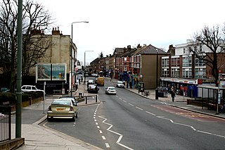
Thornton Heath is a district of South London, England, within the London Borough of Croydon. It is around 1.5 miles (2.4 km) north of the town of Croydon, and 7.2 miles (11.6 km) south of Charing Cross. Prior to the creation of Greater London in 1965, Thornton Heath was in the County Borough of Croydon.

<span class="mw-page-title-main">West Norwood</span> Suburb of London

West Norwood is a largely residential area of south London within the London Borough of Lambeth, located 5.4 miles (8.7 km) south south-east of Charing Cross. The centre of West Norwood sits in a bowl surrounded by hillsides on its east, west and south sides. From many parts of the area, distant views can be seen, of places such as the City of London, Canary Wharf and Crystal Palace.

<span class="mw-page-title-main">Birmingham Central Library</span> Former main public library in Birmingham, England

Birmingham Central Library was the main public library in Birmingham, England, from 1974 until 2013, replacing a library opened in 1865 and rebuilt in 1882. For a time the largest non-national library in Europe, it closed on 29 June 2013 and was replaced by the Library of Birmingham. The building was demolished in 2016, after 41 years, as part of the redevelopment of Paradise Circus by Argent Group. Designed by architect John Madin in the brutalist style, the library was part of an ambitious development project by Birmingham City Council to create a civic centre on its new Inner Ring Road system; however, for economic reasons significant parts of the master plan were not completed, and quality was reduced on materials as an economic measure. Two previous libraries occupied the adjacent site before Madin's library opened in 1974. The previous library, designed by John Henry Chamberlain, opened in 1883 and featured a tall clerestoried reading room. It was demolished in 1974 after the new library had opened.

Brutalist architecture is an architectural style that emerged during the 1950s in the United Kingdom, among the reconstruction projects of the post-war era. Brutalist buildings are characterised by minimalist constructions that showcase the bare building materials and structural elements over decorative design. The style commonly makes use of exposed, unpainted concrete or brick, angular geometric shapes and a predominantly monochrome colour palette; other materials, such as steel, timber, and glass, are also featured.

<span class="mw-page-title-main">Croydon</span> Town in South London, England

Croydon is a large town in South London, England, 9.3 miles (15.0 km) south of Charing Cross. Part of the London Borough of Croydon, a local government district of Greater London, it is one of the largest commercial districts in Greater London, with an extensive shopping district. The entire town had a population of 192,064 as of 2011, whilst the wider borough had a population of 384,837.

<span class="mw-page-title-main">Streatham Common</span>

Streatham Common is a large open space on the southern edge of Streatham in the London Borough of Lambeth. The shallow sloping lower (western) half of the common is mostly mowed grass, and the upper (eastern) half is mostly woodland with some small areas of gorse scrub and acid grassland. The eastern half has been designated a Local Nature Reserve.

<span class="mw-page-title-main">Sutton, London</span> Suburb of London

Sutton is a town in the London Borough of Sutton in South London, England. It is the administrative headquarters of the Outer London borough, on the lower slopes of the North Downs. It is 10 miles (16 km) south-southwest of Charing Cross, one of the fourteen metropolitan centres in the London Plan. The population of the town was counted as 41,483 in the 2011 census, while the borough overall counted 204,525.

<span class="mw-page-title-main">South Norwood</span> District of south east London, England

South Norwood is a district of south-east London, England, within the London Borough of Croydon, Greater London and formerly in the historic county of Surrey. It is located 7.8 miles (12.5 km) south-east of Charing Cross, north of Woodside and Addiscombe, east of Selhurst and Thornton Heath, south of Crystal Palace/Upper Norwood and Anerley, and south-west of Penge.

<span class="mw-page-title-main">Coulsdon Town railway station</span> National Rail station in London, England

Coulsdon Town railway station serves the northern part of Coulsdon, in the London Borough of Croydon. It is on the Tattenham Corner line 16 miles 46 chains (26.7 km) from Charing Cross and opened on 1 January 1904. Until 22 May 2011 it was called Smitham.

<span class="mw-page-title-main">Woodside, London</span> Human settlement in England

Woodside is an area in south London, in the London Borough of Croydon. It is between Addiscombe and South Norwood. It is south of South Norwood, west of Shirley and Monks Orchard, north of Addiscombe, and east of Selhurst.

<span class="mw-page-title-main">Anerley</span> Human settlement in England

Anerley is an area of south east London, England, within the London Borough of Bromley. It is located 7 miles (11 km) south south-east of Charing Cross, to the south of Crystal Palace and Upper Norwood, west of Penge, north of Elmers End and South Norwood.

<span class="mw-page-title-main">Gipsy Hill</span> Area of south London

Gipsy Hill in south London is a hilly and leafy neighbourhood spanning the southern parts of the London Boroughs of Lambeth and Southwark characterised for its stunning views of the City of London and Dulwich.

<span class="mw-page-title-main">A215 road</span> Road in London, England

The A215 is an A road in south London, starting at Elephant and Castle and finishing around Shirley. It runs through the London Boroughs of Lambeth, Southwark and Croydon.

<span class="mw-page-title-main">Beaulieu Heights</span>

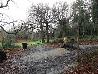
Beaulieu Heights 16 acres (6.5 ha) is an area of ancient woodland between South Norwood and Upper Norwood in the London Borough of Croydon, London. It is located between South Norwood Hill and Auckland Road with Auckland Rise to the north and Tummonds Gardens to the south. There are pedestrian entrances from South Norwood Hill and Auckland Rise, and a pond. The name is pronounced as if spelled "Beulah" like the nearby Beulah Hill, and not like the French word or the town of Beaulieu, Hampshire.

<span class="mw-page-title-main">Ashburton Park</span>

Ashburton Park is a park located in Woodside, in the London Borough of Croydon, and takes its name from nearby Ashburton.

<span class="mw-page-title-main">Croydon Central Library</span> Building in London, England

Croydon Central Library is Croydon's main public library, located inside the Croydon Clocktower in Croydon, south London. It is owned by the London Borough of Croydon on behalf of Croydon Council. The library is located on four floors inside the building. There are also children's rhymetime sessions.

<span class="mw-page-title-main">Architecture of the London Borough of Croydon</span> Building styles in London borough

The London Borough of Croydon has a wide variety of buildings mainly from post-war through to modern. Much of the modern architecture in the borough is centred on the commercial centre of the town, with much of the Victorian designs spread out on both the northern and southern corridors of the borough. Many former warehouses and factories have been converted for other uses changing the external appearance of Croydon erratically.

Thornton Heath is an area of South London, England, and makes up a part of the London Borough of Croydon.

References

  1. "London Borough of Croydon | Libraries". Archived from the original on 4 February 2007. Retrieved 4 February 2007.
  2. 1 2 "Brutalist Library - Heritage".
  3. 1 2 3 4 5 6 Chambers, Lynn; Ammon, Verena; Hickman, John (2022). "The rough diamond of Norwood". The Modernist. No. 43. pp. 67–70. ISSN   2046-2905.
  4. 1 2 "South Norwood Library | Croydon Council". www.croydon.gov.uk. Retrieved 16 January 2022.
  5. 1 2 insidecroydon (2 December 2020). "BxB-built library which has never opened is now to be closed". Inside Croydon. Retrieved 16 January 2022.
  6. 1 2 "Library in Croydon previously dubbed 'incredibly ugly' won't be demolished". Your Local Guardian. Retrieved 6 November 2022.
  7. "Home | Friends of South Norwood Library". Friends of South Nor. Retrieved 16 January 2022.
  8. "Save the building". Brutalist Library SE25. Retrieved 16 January 2022.
  9. 1 2 "General 4". Brutalist Library SE25. Retrieved 16 January 2022.
  10. "South Norwood Library | Open House London 2021". openhouselondon.open-city.org.uk. Retrieved 16 January 2022.
  11. "Library visitor figures" . Croydon Advertiser . 29 September 2017. p. 26. Retrieved 20 August 2022.
  12. "Brutalist Library SE25". Brutalist Library SE25. Retrieved 6 November 2022.
  13. "Library Consultation 2024". Brutalist Library SE25. Retrieved 5 June 2024.
  14. "The Croydonist explore South Norwood's brutalist library". Croydonist. 9 September 2021. Retrieved 20 August 2022.
  15. "South Norwood Library | AccessAble".
  16. Heathcote, Edwin (24 August 2021). "London's big week for architecture fans". Financial Times.
  17. "Open House 2021 reveals 'top 10' must-see buildings in London". 11 August 2021.
  18. "Croydon UNISON Libraries Consultation Meeting with Cllr Oliver Lewis Monday 8th February 2021". Croydon Local Government. 18 February 2021. Retrieved 20 August 2022.
  19. "Author shares the joy of reading" . Greater London, Kent, and Surrey Counties Publications (England). 2 July 2001. Retrieved 20 August 2022.
  20. "Strong writing" . Greater London, Kent, and Surrey Counties Publications (England). 21 November 2001. Retrieved 20 August 2022.

51°23′51″N0°04′43″W / 51.3974°N 0.0787°W / 51.3974; -0.0787