Southbourne, Dorset

Last updated

Southbourne
Southbournebeach.JPG
Southbourne beach
Dorset UK location map.svg
Red pog.svg
Southbourne
Location within Dorset
Population18,960 (2 wards, 2011) [1] [2]
OS grid reference SZ142913
Unitary authority
Ceremonial county
Region
Country England
Sovereign state United Kingdom
Post town BOURNEMOUTH
Postcode district BH6
Dialling code 01202
Police Dorset
Fire Dorset and Wiltshire
Ambulance South Western
UK Parliament
List of places
UK
England
Dorset
50°43′19″N1°47′53″W / 50.722°N 1.798°W / 50.722; -1.798

Southbourne is a suburb of Bournemouth, in the unitary authority area of Bournemouth, Christchurch and Poole, in the ceremonial county of Dorset, England. It is situated between Boscombe and Christchurch. The area was previously known as Stourfield. Strictly, Southbourne refers to the area near to the coast; areas further inland are West Southbourne, Tuckton and Wick. It was historically part of Hampshire until 1974. [3]

Contents

History

Southbourne was the creation of Thomas Armetriding Compton, an enterprising young physician, who set up general practice in Bournemouth in 1866 and could see the area's potential as a health resort. Prior to his arrival the clifftop land here had been part and parcel of Tuckton Farm, Southbourne being founded precisely where the piggeries had stood. [4] This area of clifftop land was purchased by Compton in 1871 and was later developed by the Southbourne-on-Sea Freehold Land Company, founded in 1882 with Compton as principal shareholder.

Some older properties did exist on the outskirts of the area. Around 1766, for instance, Edmund Bott had built a Georgian mansion to the east of Pokesdown village, commanding views of Christchurch Harbour; he named it Stourfield House. One of the most celebrated inhabitants of Stourfield House was Mary Eleanor Bowes, Countess of Strathmore and Kinghorne, a notorious eccentric who used to set places for her pet dogs at the dinner-table. Stourfield House later became a care home, mainly for servicemen who had been injured in the Great War. Today only the front steps survive, leading to a block of flats in Douglas Mews; the steps are marked by a Blue Plaque. The original, extended building was demolished in 1990.

Southbourne also had a short-lived pier. It was built by Compton's company in 1888 at a cost of £4,000 and was 300 feet long. There were regular boat-trips between the pier at Southbourne and the pier at Bournemouth. Unfortunately the pier, promenade and nearby sea wall built by Dr. Compton (to rival the resort at Bournemouth) were heavily damaged by storms in December 1900 and January 1901. A buyer for the pier was unable to be found and it was eventually demolished in 1909 due to public safety concerns. [5]

On 11 July 1910, Britain’s first international aviation meeting was held on a specially laid out aerodrome consisting of a mile of grassland between Tuckton and the "Double Dykes" near Hengistbury Head. Aviators from around the world competed in a variety of contests, including spot landing, altitude tests, and speed trials (both for the fastest and slowest circuit). [6] Charles Stewart Rolls, co-founder of Rolls-Royce and pioneer aviator was killed on the second day of the meeting, while attempting a precision landing. [7] The event was Britain’s earliest fatal flying accident involving a powered aircraft. [6] The site is marked by a memorial on the sports fields of St Peter's School.

In 1894 Southbourne became a separate civil parish, being formed from part of Christchurch, on 30 September 1902 the parish was abolished and merged with Bournemouth. [8] In 1901 the parish had a population of 799. [9] It is now in the unparished area of Bournemouth.

Today

Southbourne is a more relaxed, but still bustling locale for tourists keen to escape the busier areas of Bournemouth town centre, although the number of guest houses in the area has declined in recent years. The main area of Southbourne is Southbourne Grove, a long shopping street that has some unique and individual shops rather than high street chain shops. Another local centre is Southbourne Crossroads, which is further east towards Hengistbury Head. Seafield Gardens is a public open space which has, since 2001, won a Green Flag Award; it offers various outdoor facilities, including bowls and tennis. It also features a watertower. The easternmost part of the area is called Hengistbury Head.

Southbourne's primary attraction is its sandy Blue Flag beach, which provides a quieter retreat from the more crowded beach along the coast at Bournemouth. [10] Between the clifftop coastal road and the promenade and beach is the Fisherman's Walk Cliff Railway, a funicular railway that provides very easy access to Southbourne beach, and from where it is possible to reach the beaches at Boscombe and Bournemouth.

In recent years there has been an increase in the construction of apartment buildings and holiday homes near the sea,[ citation needed ] examples including the Saltaire Building which was constructed in the early 2000s.

Related Research Articles

<span class="mw-page-title-main">Bournemouth</span> Town in Dorset, England

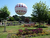
Bournemouth is a coastal resort town on the south coast in the Bournemouth, Christchurch and Poole unitary authority area in the ceremonial county of Dorset, England. The town's urban subdivision had a population of 187,503 at the 2011 census making it the largest town in the county; the town is part of the South East Dorset conurbation, which has a population of 465,000.

<span class="mw-page-title-main">Christchurch, Dorset</span> Town and civil parish in England

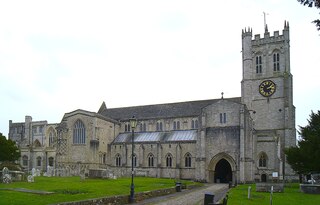
Christchurch is a town and civil parish on the south coast of Dorset, England. The parish had a population of 31,372 in 2021. It adjoins Bournemouth to the west, with the New Forest to the east. Part of the historic county of Hampshire, Christchurch was a borough within the administrative county of Dorset from 1974 until 2019, when it became part of the new Bournemouth, Christchurch and Poole unitary authority.

<span class="mw-page-title-main">Boscombe</span> Suburb of Bournemouth, England

Boscombe is a suburb of Bournemouth, England. Historically in Hampshire, but today in Dorset, it is located to the east of Bournemouth town centre and west of Southbourne.

<span class="mw-page-title-main">Milford on Sea</span> Human settlement in England

Milford on Sea, often hyphenated, is a large coastal village and civil parish in the New Forest district, on the Hampshire coast, England. The parish had a population of 4,660 at the 2011 census and is centred about 3 miles (4.8 km) south of Lymington. Tourism and businesses for quite prosperous retirees as well as the care sector make up large parts of its economy. Businesses include restaurants, cafés, tea rooms, small shops, garden centres, pubs and camping/lodge/caravan parks, bed-and-breakfasts and a few luxury hotels. Shops cluster on its small high street, which fronts a village green. The western cliffs are accessed by flights of steps. In common with the flatter coast by the more commercial and eastern part of Milford, they have car parks with some facilities, which, along with many apartment blocks and houses, have close views of The Needles, which are the main, large chalk rocks immediately next to the Isle of Wight.

<span class="mw-page-title-main">Bournemouth East (UK Parliament constituency)</span> UK Parliament constituency in England since 1974

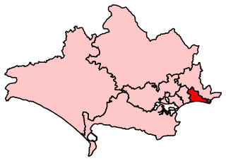
Bournemouth East is a parliamentary constituency in Dorset represented in the House of Commons of the UK Parliament since 2005 by Tobias Ellwood, a Conservative.

<span class="mw-page-title-main">Hengistbury Head</span> Headland and archeological site in Dorset

Hengistbury Head, formerly also called Christchurch Head, is a headland jutting into the English Channel between Bournemouth and Mudeford in the English county of Dorset. It is a site of international importance in terms of its archaeology and is scheduled as an Ancient Monument. Declared a Local Nature Reserve in 1990, the head and its surroundings form part of the Christchurch Harbour Site of Special Scientific Interest. It is also a Special Area of Conservation, Special Protection Area, an Environmentally Sensitive Area and a Site of Nature Conservation Interest. The name "Hengistbury Head" refers to the whole of the headland area; the elevated portion is called Warren Hill.

<span class="mw-page-title-main">Poole Bay</span>

Poole Bay is a bay in the English Channel, on the coast of Dorset in southern England, which stretches 16 km from Sandbanks at the mouth of Poole Harbour in the west, to Hengistbury Head in the east. Poole Bay is a relatively shallow embayment and consists of steep sandstone cliffs and several 'chines' that allow easy access to the sandy beaches below. The coast along the bay is continuously built up, and is part of the South East Dorset conurbation, including parts of the towns of Poole, Bournemouth and Christchurch. The bay is sometimes referred to as Bournemouth Bay, because much of it is occupied by Bournemouth.

<span class="mw-page-title-main">Pokesdown</span> Human settlement in England

Pokesdown is a suburb of Bournemouth, in the Bournemouth, Christchurch and Poole district, in the ceremonial county of Dorset, England. It lies just east of Boscombe and west of Southbourne.

<span class="mw-page-title-main">Bournemouth Coast Path</span>

The Bournemouth Coast Path is a 20-mile-long footpath through Dorset and Hampshire, England from Sandbanks to Milford-on-Sea.

<span class="mw-page-title-main">Christchurch Harbour</span> Human settlement in England

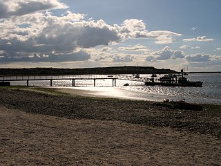
Christchurch Harbour is a natural harbour in the county of Dorset, on the south coast of England named after the nearby town of Christchurch. Two rivers, the Avon and the Stour, flow into the Harbour at its northwest corner. The harbour is generally shallow and due to the tidal harmonics in the English Channel has a double high water on each tide. On the north side of the harbour, east of the Avon are Priory Marsh, and to the east of this Stanpit Marsh, a Local Nature Reserve. To the west side of the harbour are Wick Fields, the southern flank of the harbour being bounded by Hengistbury Head, a prominent coastal headland. The harbour flows into the Christchurch Bay and the English Channel through a narrow channel known locally as The Run which rests between Mudeford Quay and Mudeford Spit. Shallow-draught boats can enter from this channel and cruise up stream for 2 miles (3 km) choosing either the Avon or the Stour, the Stour leading up as far as Iford Bridge passing Christchurch Quay and Tuckton.

<span class="mw-page-title-main">Wick, Bournemouth</span> Human settlement in England

Wick is a village on the south bank of the River Stour in Dorset, England, just short of the Stour's entry into Christchurch Harbour. Along with the nearby village of Tuckton, it originally formed a tithing in the Hundred of Christchurch, before becoming part of the Civil Parish of Southbourne in 1894. The latter was incorporated into the Borough of Bournemouth in 1901.

<span class="mw-page-title-main">History of Bournemouth</span> Coastal city in southern England

The history of Bournemouth and human settlement in the surrounding area goes back for thousands of years. Bournemouth is a coastal town on the island of Great Britain in Dorset, England, United Kingdom.

Mudeford is a harbourside and beachside parish based on a former fishing village in the east of Christchurch, Dorset, England, fronting water on two sides: Christchurch Harbour and the sands of Avon Beach.

Tuckton is a suburb of Bournemouth, situated on the River Stour in the eastern part of the borough. First recorded in 1271, this was a hamlet in the tithing of Tuckton and Wick until 1894, when the Local Government Act replaced all tithings in England and Wales with civil parishes and district councils. At that point, Tuckton became part of the civil parish of Southbourne, which was absorbed into the Borough of Bournemouth in 1901.

<span class="mw-page-title-main">East Southbourne and Tuckton (ward)</span> Ward in Bournemouth, Dorset, UK

East Southbourne and Tuckton is a ward in Bournemouth, Dorset. Since 2019, the ward has elected 2 councillors to Bournemouth, Christchurch and Poole Council.

<span class="mw-page-title-main">West Southbourne (ward)</span>

West Southbourne is a ward in Bournemouth, Dorset. Since 2019, the ward has elected 2 councillors to Bournemouth, Christchurch and Poole Council.

References

  1. "East Southbourne and Tuckton ward 2011" . Retrieved 7 April 2015.
  2. "West Southbourne ward 2011" . Retrieved 7 April 2015.
  3. "GB Historical GIS / University of Portsmouth, History of Southbourne, in Bournemouth and Hampshire | Map and description, A Vision of Britain through Time". 12 December 2020.
  4. A. McKinstry, The Village of Tuckton, 35,000 BC - 1926 (Christchurch: Natula Publications, 2015, ISBN   9781897887325), p. 21.
  5. National Piers Society. "History of Southbourne Pier" . Retrieved 11 November 2010.
  6. 1 2 Bournemouth’s flying circuses | Dorset Life - The Dorset Magazine
  7. Hengistbury Head from the Romans to the 20th Century
  8. "Christchurch Registration District". UKBMD. Retrieved 19 April 2024.
  9. "Population statistics Southbourne CP through time". A Vision of Britain through Time. Retrieved 19 April 2024.
  10. "Southbourne" . Retrieved 21 December 2012.