
The Maryland Transit Administration (MTA) is a state-operated mass transit administration in Maryland, and is part of the Maryland Department of Transportation. The MTA operates a comprehensive transit system throughout the Washington-Baltimore metropolitan area. There are 80 bus lines serving the Baltimore Metropolitan Area, along with rail services that include the Light Rail, Metro Subway, and MARC Train. In 2022, the system had a ridership of 52,922,000, or about per weekday as of the third quarter of 2023.
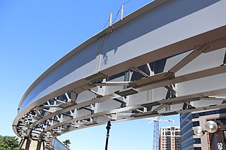
The Purple Line is a 16.2-mile (26.1 km) light rail line being built to link several Maryland suburbs of Washington, D.C.: Bethesda, Silver Spring, College Park, and New Carrollton. Currently slated to open in 2027, the line will also enable riders to move between the Maryland branches of the Red, Green, and Orange lines of the Washington Metro without riding into central Washington, and between all three lines of the MARC commuter rail system. The project is administered by the Maryland Transit Administration (MTA), an agency of the Maryland Department of Transportation (MDOT), and not the Washington Metropolitan Area Transit Authority (WMATA), which operates Metro.

The Metro SubwayLink is a rapid transit line serving Baltimore, Maryland, and its northwestern suburbs, operated by the Maryland Transit Administration. The segment in Downtown Baltimore is underground, while most of the line outside the central city is elevated or at surface grade. In 2022, the line had a ridership of 1,988,300, or about per weekday as of the third quarter of 2023.

Baltimore Light RailLink is a light rail system serving Baltimore, Maryland, United States, and its northern and southern suburbs. It is operated by the Maryland Transit Administration. In downtown Baltimore, it uses city streets. Outside the central portions of the city, the line is built on private rights-of-way, mostly from the defunct Northern Central Railway, Baltimore and Annapolis Railroad and Washington, Baltimore and Annapolis Electric Railway. The system had a ridership of 3,262,100, or about 14,600 per weekday, as of the third quarter of 2023.
The Red Line is a proposed east–west transit line for Baltimore, Maryland. The original project was granted federal approval to enter the preliminary engineering phase and the Maryland Transit Administration had spent roughly $300 million in planning, design and land acquisition, until Maryland Governor Larry Hogan declared his intent to not provide state funds for the project and shift state funding to roads in suburban areas. The original Red Line had been projected to cost roughly $1.6 billion, $900 million of which would have been guaranteed federal funding. Its construction had been estimated to begin in late 2015–early 2016, subject to funding, with a completion date set for late 2021–early 2022.
The Green Line is a proposed mass transit line for the Baltimore, Maryland area in the United States. It is still in the planning stages and its construction is not guaranteed.
The Northern Branch Corridor Project is a proposed extension of the Hudson-Bergen Light Rail (HBLR) from its northern terminus into eastern Bergen County, New Jersey, initially proposed in 2001. If built, the new service would use the right-of-way of the Northern Branch on which the Erie Lackawanna Railroad ran passenger service until October 3, 1966, and is currently a lightly used, stub-ended freight rail line owned by CSX Transportation. The Northern Branch Corridor is at the foot of the west side of the Hudson Palisades in the Hackensack River valley, running for much of its length parallel to Overpeck Creek. After mixed reactions and extensive community input to a draft environmental impact statement (EIS), it was decided in 2013 to terminate the line at the Englewood Hospital and Medical Center. In March 2017 the Supplementary Draft Environmental Impact Statement was approved by the Federal Transit Administration allowing for a period of public reaction. A separately-conceived and funded bridge at 69th Street in North Bergen, necessary for operation of the system, has been completed. In 2017 NJ Transit estimated that the line would open in 2029.
Staten Island light rail proposals refer to two projects in the New York City borough of Staten Island. These proposals are among the several light rail projects that have been floated in New York City in recent years. Neither proposal was funded in the Metropolitan Transportation Authority's 2015–2019 Capital Plan, but $4 million was allocated to a study for it.

LocalLink 80 is a bus route operated by the Maryland Transit Administration in Baltimore, Maryland, in the United States. LocalLink 80 is part of the high frequency network of the local bus system. The route consists of a leg originating in Downtown Baltimore and goes on to serve the Garrison Boulevard corridor in the northwest of the city. Route 80 and its predecessor, route 91, has carried some of the highest ridership out of Baltimore's local bus network throughout its history. The line was the first in the city to be assigned articulated buses, which are now used to meet the higher capacity requirements of the frequent lines.

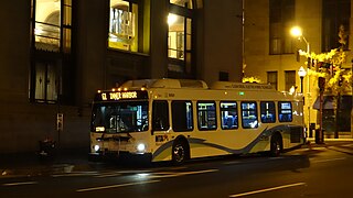
CityLink Red is a MTA BaltimoreLink bus route operated by the Maryland Transit Administration in Baltimore and its suburbs. The line currently runs from the University of Maryland Transit Center to the Lutherville Light Rail Stop along the corridors of York Road and Greenmount Avenue, and is the most heavily used MTA bus line. The CityLink Red bus replaced Route 8 bus route due to BaltimoreLink, and is the successor to the 8 Towson and 7 Govanstown streetcar lines.
Route 51 is a bus route operated by the Maryland Transit Administration in Baltimore and its suburbs. The line currently runs from the center of Towson to the Inner Harbor in Downtown Baltimore, serving the Charles Street corridor. Route 51 replaced Route 11 on June 18, 2017 due to the BaltimoreLink bus system overhaul.
LocalLink 95 is a bus route operated by the Maryland Transit Administration in Baltimore. The line currently runs from the intersection of Roland Avenue and Lake Avenue in Roland Park south to the Inner Harbor via Roland Avenue, University Parkway, Charles Street and St. Paul Street.
The Bottineau LRT is a proposed light rail line extension in the Minneapolis – Saint Paul Metro area, projected to run northwest from Target Field station in downtown Minneapolis along County Road 81 to Brooklyn Park.
The Central Maryland Transportation Alliance (CMTA) is a coalition of Baltimore area business, civic and nonprofit groups intent on improving travel within Central Maryland, which consists of Baltimore City and the surrounding jurisdictions of Anne Arundel County, Baltimore County, Carroll County, Harford County and Howard County. The group's stated objectives are to reduce congestion, limit sprawl, increase job opportunities and make it easier, faster and more efficient for anyone to travel within Central Maryland.

The West Santa Ana Branch is a rail right-of-way formerly used by the Pacific Electric's (PE) Santa Ana route in Los Angeles County and Orange County in Southern California. The Los Angeles County Metropolitan Transportation Authority (Metro) owns the segment of the right-of-way in Los Angeles County, and the Orange County Transportation Authority (OCTA) owns the segment in Orange County.
The Yellow Line is a mass transit line proposed by the Baltimore Regional Rail Plan in March 2002 for the Baltimore, Maryland area. It would begin at Columbia Town Center in Columbia, Maryland, and end in Hunt Valley, Maryland at Shawan Road.
The Charles Street Trolley is a proposed trolley line running through northern portions of Baltimore, Maryland, United States. Kittelson & Associates, Inc., a consulting firm hired by trolley advocates, estimates that the line would be likely to carry 2.5 million riders per year.

The North Shore Branch is an abandoned branch of the Staten Island Railway in New York City, which operated along Staten Island's North Shore from Saint George to Port Ivory. The line continues into New Jersey via the Arthur Kill Vertical Lift Bridge to Aldene Junction in Cranford.
The West Santa Ana Branch Transit Corridor is a planned light rail line, mostly following the Pacific Electric's historic West Santa Ana Branch, connecting Downtown Los Angeles to the city of Artesia, along with other cities in southeastern Los Angeles County.
The Interborough Express (IBX) is a proposed 14-mile (22.5 km) and 24/7 light rail line in New York City. As proposed, the line would use the existing right-of-way from the Bay Ridge Branch and Fremont Secondary to connect Bay Ridge, Brooklyn and Jackson Heights, Queens, but operate on its own separate tracks. Near the All Faiths Cemetery in Queens, IBX would operate on the street. As of 2023 the Metropolitan Transportation Authority (MTA) estimated that the project would be operational in 2027.