Related Research Articles

Subduction is a geological process in which the oceanic lithosphere is recycled into the Earth's mantle at convergent boundaries. Where the oceanic lithosphere of a tectonic plate converges with the less dense lithosphere of a second plate, the heavier plate dives beneath the second plate and sinks into the mantle. A region where this process occurs is known as a subduction zone, and its surface expression is known as an arc-trench complex. The process of subduction has created most of the Earth's continental crust. Rates of subduction are typically measured in centimeters per year, with the average rate of convergence being approximately two to eight centimeters per year along most plate boundaries.

The Ring of Fire is a region around much of the rim of the Pacific Ocean where many volcanic eruptions and earthquakes occur. The Ring of Fire is a horseshoe-shaped belt about 40,000 km (25,000 mi) long and up to about 500 km (310 mi) wide.

A convergent boundary is an area on Earth where two or more lithospheric plates collide. One plate eventually slides beneath the other, a process known as subduction. The subduction zone can be defined by a plane where many earthquakes occur, called the Wadati–Benioff zone. These collisions happen on scales of millions to tens of millions of years and can lead to volcanism, earthquakes, orogenesis, destruction of lithosphere, and deformation. Convergent boundaries occur between oceanic-oceanic lithosphere, oceanic-continental lithosphere, and continental-continental lithosphere. The geologic features related to convergent boundaries vary depending on crust types.
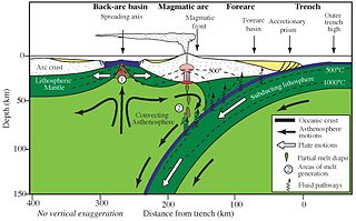
A volcanic arc is a chain of volcanoes formed above a subducting plate, positioned in an arc shape as seen from above. Offshore volcanoes form islands, resulting in a volcanic island arc. Generally, volcanic arcs result from the subduction of an oceanic tectonic plate under another tectonic plate, and often parallel an oceanic trench. The oceanic plate is saturated with water, and volatiles such as water drastically lower the melting point of the mantle. As the oceanic plate is subducted, it is subjected to greater and greater pressures with increasing depth. This pressure squeezes water out of the plate and introduces it to the mantle. Here the mantle melts and forms magma at depth under the overriding plate. The magma ascends to form an arc of volcanoes parallel to the subduction zone.

The Hikurangi Trench, also called the Hikurangi Trough, is an oceanic trench in the bed of the Pacific Ocean off the east coast of the North Island of New Zealand, lying between the southern end of the Cook Strait and the Chatham Rise. It is the southward continuation of the much deeper Kermadec Trench. It lies in the Hikurangi Margin subduction zone, which is the southern extension of the Kermadec-Tonga subduction zone. The Hikurangi Margin is the subduction zone where the thick oceanic Hikurangi Plateau is subducting beneath continental crust of the Indo-Australian Plate. By contrast, the Kermadec and Tonga trenches represent the parts of the subduction zone where oceanic crust of the Pacific Plate is subducting beneath oceanic crust of the Indo-Australian Plate.
Megathrust earthquakes occur at convergent plate boundaries, where one tectonic plate is forced underneath another. The earthquakes are caused by slip along the thrust fault that forms the contact between the two plates. These interplate earthquakes are the planet's most powerful, with moment magnitudes (Mw) that can exceed 9.0. Since 1900, all earthquakes of magnitude 9.0 or greater have been megathrust earthquakes.

An orogenic belt, or orogen, is a zone of Earth's crust affected by orogeny. An orogenic belt develops when a continental plate crumples and is uplifted to form one or more mountain ranges; this involves a series of geological processes collectively called orogenesis.
In geology, continental collision is a phenomenon of plate tectonics that occurs at convergent boundaries. Continental collision is a variation on the fundamental process of subduction, whereby the subduction zone is destroyed, mountains produced, and two continents sutured together. Continental collision is only known to occur on Earth.

The Gulf of Cádiz is the arm of the Atlantic Ocean between Cabo de Santa Maria, the southernmost point of Mainland Portugal and Cape Trafalgar at the western end of the Strait of Gibraltar. Two major rivers, the Guadalquivir and the Guadiana, as well as smaller rivers, like the Odiel, the Tinto, and the Guadalete, reach the ocean here.

The Valais Ocean is a subducted oceanic basin which was situated between the continent Europe and the microcontinent Iberia or so called Briançonnais microcontinent. Remnants of the Valais ocean are found in the western Alps and in tectonic windows of the eastern Alps and are mapped as the so-called "north Penninic" nappes.

The Andean Volcanic Belt is a major volcanic belt along the Andean cordillera in Argentina, Bolivia, Chile, Colombia, Ecuador, and Peru. It is formed as a result of subduction of the Nazca Plate and Antarctic Plate underneath the South American Plate. The belt is subdivided into four main volcanic zones which are separated by volcanic gaps. The volcanoes of the belt are diverse in terms of activity style, products, and morphology. While some differences can be explained by which volcanic zone a volcano belongs to, there are significant differences within volcanic zones and even between neighboring volcanoes. Despite being a type location for calc-alkalic and subduction volcanism, the Andean Volcanic Belt has a broad range of volcano-tectonic settings, as it has rift systems and extensional zones, transpressional faults, subduction of mid-ocean ridges and seamount chains as well as a large range of crustal thicknesses and magma ascent paths and different amounts of crustal assimilations.

The Gibraltar Arc is a geological region corresponding to an arcuate orogen surrounding the Alboran Sea, between the Iberian Peninsula and Africa. It consists of the Betic Cordillera, and the Rif. The Gibraltar Arc is located at the western end of the Mediterranean Alpine belt and formed during the Neogene due to convergence of the Eurasian and African plates.
The Azores–Gibraltar Transform Fault (AGFZ), also called a fault zone and a fracture zone, is a major seismic zone in the Eastern Atlantic Ocean between the Azores and the Strait of Gibraltar. It is the product of the complex interaction between the African, Eurasian, and Iberian plates. The AGFZ produced the large-magnitude 1755 Lisbon, 1761 Lisbon, 1816 North Atlantic, 1941 Gloria Fault earthquake, 1969 Horseshoe and 1975 earthquakes and, consequently, a number of large tsunamis.

The Solomon Sea Plate is a minor tectonic plate to the northwest of the Solomon Islands in the south Pacific Ocean, it roughly corresponds with the Solomon Sea east of Papua New Guinea.

The Iberian Plate with the microcontinent Iberia encompassed not only the Iberian Peninsula but also Corsica, Sardinia, the Balearic Islands, and the Briançonnais zone of the Penninic nappes of the Alps. The Iberian plate is a part of the Eurasian plate.

In geology, a slab window is a gap that forms in a subducted oceanic plate when a mid-ocean ridge meets with a subduction zone and plate divergence at the ridge and convergence at the subduction zone continue, causing the ridge to be subducted. Formation of a slab window produces an area where the crust of the over-riding plate is lacking a rigid lithospheric mantle component and thus is exposed to hot asthenospheric mantle. This produces anomalous thermal, chemical and physical effects in the mantle that can dramatically change the over-riding plate by interrupting the established tectonic and magmatic regimes. In general, the data used to identify possible slab windows comes from seismic tomography and heat flow studies.
The Lesser Antilles subduction zone is a convergent plate boundary on the seafloor along the eastern margin of the Lesser Antilles Volcanic Arc. In this subduction zone, oceanic crust of the South American Plate is being subducted under the Caribbean Plate.
In geology, the slab is a significant constituent of subduction zones.
The Hikurangi Margin is an active subduction zone extending off the east coast of New Zealand's North Island, where the Pacific and Australian plates collide. It is the southern portion of the Tonga–Kermadec–Hikurangi subduction zone and its main feature is the Hikurangi Trench.

The Chile Ridge, also known as the Chile Rise, is a submarine oceanic ridge formed by the divergent plate boundary between the Nazca Plate and the Antarctic Plate. It extends from the triple junction of the Nazca, Pacific, and Antarctic plates to the Southern coast of Chile. The Chile Ridge is easy to recognize on the map, as the ridge is divided into several segmented fracture zones which are perpendicular to the ridge segments, showing an orthogonal shape toward the spreading direction. The total length of the ridge segments is about 550–600 km.
References
| | This tectonics article is a stub. You can help Wikipedia by expanding it. |
| | This Portugal-related article is a stub. You can help Wikipedia by expanding it. |