St Margaret's Road

Last updated

View east from the junction with Woodstock Road. St Margaret's Road, east from Woodstock Road, Oxford.JPG
View east from the junction with Woodstock Road.

St Margaret's Road is a road in North Oxford, England. [1]

North Oxford suburban part of the city of Oxford in England

North Oxford is a suburban part of the city of Oxford in England. It was owned for many centuries largely by St John's College, Oxford and many of the area's Victorian houses were initially sold on leasehold by the College.

England Country in north-west Europe, part of the United Kingdom

England is a country that is part of the United Kingdom. It shares land borders with Wales to the west and Scotland to the north-northwest. The Irish Sea lies west of England and the Celtic Sea lies to the southwest. England is separated from continental Europe by the North Sea to the east and the English Channel to the south. The country covers five-eighths of the island of Great Britain, which lies in the North Atlantic, and includes over 100 smaller islands, such as the Isles of Scilly and the Isle of Wight.

Contents

Location

The road runs between Kingston Road to the west and Banbury Road to the east, crossing Woodstock Road. To the south are Farndon Road to the west and Canterbury Road to the east. To the north are Polstead Road (west) and Rawlinson Road (east).

Kingston Road, Oxford

Kingston Road is a road in Oxford, England. It continues north from Walton Street, at the junction with Walton Well Road to the west and St Bernard's Road to the east, running parallel with and to the west of Woodstock Road. Kingston Road is the main road in Walton Manor. At the northern end, there is a staggered junction with Aristotle Lane to the west and Polstead Road to the east. The road continues as Hayfield Road. Southmoor Road and Southmoor Place lead off Kingston Road to the west.

Banbury Road street in the United Kingdom

Banbury Road is a major arterial road in Oxford, England, running from St Giles' at the south end, north towards Banbury through the leafy suburb of North Oxford and Summertown, with its local shopping centre. Parallel and to the west is the Woodstock Road, which it meets at the junction with St Giles'. To the north, Banbury Road meets the Oxford Ring Road at a roundabout. The road is designated the A4165. Prior to the building of the M40 motorway extension in 1990, the road formed part of the A423 from Maidenhead to Coventry.

Woodstock Road, Oxford

Woodstock Road is a major road in Oxford, England, running from St Giles' to the south, north towards Woodstock through the leafy suburb of North Oxford. To the east is Banbury Road, which it meets at the junction with St Giles'.

The main entrance of St Hugh's College, the northernmost Oxford college and one of the former women's colleges, is on the south side of the road. The grounds of the College stretch along the road from Woodstock Road to Banbury Road.

St Hughs College, Oxford college of the University of Oxford

St Hugh's College is one of the constituent colleges of the University of Oxford. It is located on a 14.5-acre (5.9-hectare) site on St Margaret's Road, to the north of the city centre. It was founded in 1886 by Elizabeth Wordsworth as a women's college, and accepted its first male students in its centenary year in 1986.

University of Oxford Collegiate research university in Oxford, England

The University of Oxford is a collegiate research university in Oxford, England. There is evidence of teaching as far back as 1096, making it the oldest university in the English-speaking world and the world's second-oldest university in continuous operation. It grew rapidly from 1167 when Henry II banned English students from attending the University of Paris. After disputes between students and Oxford townsfolk in 1209, some academics fled north-east to Cambridge where they established what became the University of Cambridge. The two 'ancient universities' are frequently jointly referred to as 'Oxbridge'. The history and influence of the University of Oxford has made it one of the most prestigious universities in the world.

On the northeast corner with Kingston Road at the western end is St Margaret's parish church. [2] [3]

St Margarets Church, Oxford Church in Oxford, United Kingdom

St Margaret's Church is a church in North Oxford, England. It is near the northern end of Kingston Road, at the corner of St Margaret's Road.

Green Templeton College has accommodation in several houses on St Margaret's Road. [4]

History

Rackham Lane, which later became St Margaret's Road, was laid out in 1879 as part of the Norham Manor estate.[ citation needed ] According to Henry Taunt, the part of the road between Banbury Road and Woodstock Road was called Gallows-Baulk Road. When the road was improved, the remains of several people who had been hanged were found.

Norham Manor

The Norham Manor estate is a residential suburb in Oxford, England. It is part of central North Oxford. To the north is Park Town with its crescents, to the east is the River Cherwell, to the south are the University Parks and to the west is Walton Manor, on the other side of Banbury Road.

Henry Taunt British photographer

Henry William Taunt (1842–1922) was a professional photographer, author, publisher and entertainer based in Oxford, England.

The houses in St Margaret's Road were mostly designed by William Wilkinson and Harry Wilkinson Moore in partnership. [1] They were built between 1879 and 1886. [5] The main buildings of St Hugh's College are by Herbert Tudor Buckland and William Haywood, dating from 1914–16 and built in a neo-Georgian style.

Related Research Articles

Summertown, Oxford suburb of Oxford, England

Summertown in North Oxford is a suburb of Oxford, England.

Keble Road

Keble Road is a short road running east-west in central Oxford, England. To the west is the southern end of the Banbury Road with St Giles' Church opposite. To the east is Parks Road with the University Parks opposite. Blackhall Road leads off the road to the south near the western end.

Bardwell Road

Bardwell Road is a road in North Oxford, England, off the Banbury Road.

Bevington Road

Bevington Road is a residential road in central North Oxford, England.

Canterbury Road

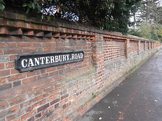
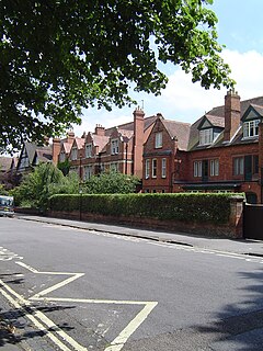
Canterbury Road is a road in North Oxford, England. It runs between Woodstock Road to the west and Banbury Road to the east. Winchester Road leads south from halfway along Canterbury Road, linking with Bevington Road that runs parallel to the south. Also to the south are North Parade and Church Walk.

Winchester Road, Oxford

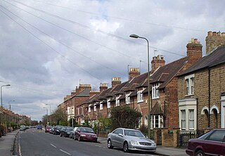
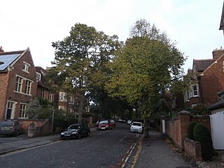
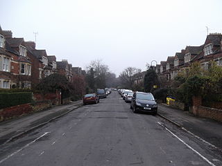
Winchester Road is a road in North Oxford, England. It runs north-south between and roughly parallel with Woodstock Road to the west and Banbury Road to the east. It is in a desirable area with high house prices.

Polstead Road

Polstead Road is a residential road that runs between Kingston Road and Hayfield Road to the west and the Woodstock Road to the east, in the suburb of North Oxford, England. Halfway along it forms the southern junction of Chalfont Road. The road is probably named after the village of Polstead in the county of Suffolk.

Charlbury Road

Charlbury Road is a road in North Oxford, England, running to the east of and parallel with the Banbury Road.

Harry Wilkinson Moore British architect

Harry Wilkinson Moore, FRIBA (1850–1915) was a Victorian and Edwardian architect. He was the son of Arthur Moore (1814–1873) and Mary Wilkinson (1821–1904), and a nephew of the architects George Wilkinson and William Wilkinson.

Chalfont Road

Chalfont Road is a road in Walton Manor, north Oxford, England.

Norham Road

Norham Road lies east off the Banbury Road in central North Oxford, a suburb in the city of Oxford, England.

Rawlinson Road

Rawlinson Road is a residential road in North Oxford, England.

Farndon Road

Farndon Road is a residential road in North Oxford, England.

William Wilkinson (architect) British Gothic Revival architect

William Wilkinson (1819–1901) was a British Gothic Revival architect who practised in Oxford, England.

References

  1. 1 2 Hinchcliffe, Tanis (1992). North Oxford. New Haven & London: Yale University Press. pp. 1, 53, 79–81, 85, 121, 236–237. ISBN   0-14-071045-0.
  2. The Church Building Archived 14 January 2014 at the Wayback Machine ., St Margaret's Church.
  3. Short History Archived 8 February 2007 at the Wayback Machine ., St Margaret's Church, Oxford.
  4. St Margaret's Road Archived 4 May 2009 at the Wayback Machine ., Green Templeton College, University of Oxford, UK.
  5. Sherwood, Jennifer; Pevsner, Nikolaus (1974). The Buildings of England: Oxfordshire. Penguin Books. p. 247, 293, 321. ISBN   0-14-071045-0.

Coordinates: 51°46′02″N1°15′53″W / 51.76722°N 1.26472°W / 51.76722; -1.26472