


Woodstock Road is a major road in Oxford, England, running from St Giles' in the south, north towards Woodstock through the leafy suburb of North Oxford. [1] To the east is Banbury Road, which it meets at the junction with St Giles'.
Woodstock Road is a major road in Oxford, England, running from St Giles' in the south, north towards Woodstock through the leafy suburb of North Oxford. [1] To the east is Banbury Road, which it meets at the junction with St Giles'.
At the southern end, just north of Little Clarendon Street, are the Oratory Church of St Aloysius Gonzaga and Somerville College. Opposite Little Clarendon Street is St Giles' Church, built in 1120 and consecrated in 1200. Further north are Green Templeton College, St Anne's College and St Antony's College. Also on Woodstock Road is St Philip and St James Church, now the Oxford Centre for Mission Studies (OCMS) and St. Edward's School which is a prominent feature halfway down. Woodstock Road Baptist Church is an evangelical church on the corner with Beech Croft Road. [2] Jack FM and Jack 2, local radio broadcasters covering Oxfordshire, are based at 270 Woodstock Road, along with the local TV channel SIX TV.
The road is classified A4144.
Former residents include: [3]
St Anne's College is a constituent college of the University of Oxford in England. It was founded in 1879 and gained full college status in 1959. Originally a women's college, it has admitted men since 1979. It has some 450 undergraduate and 200 graduate students and retains an original aim of allowing women of any financial background to study at Oxford. A recent count shows St Anne's accepting the highest proportion of female students of any college. The college stands between Woodstock and Banbury roads, next to the University Parks. In April 2017, Helen King, a retired Metropolitan Police Assistant Commissioner, took over as Principal from Tim Gardam. Former members include Amanda Pritchard, Danny Alexander, Ruth Deech, Helen Fielding, Martha Kearney, Simon Rattle, Tina Brown, Mr Hudson, and Victor Ubogu.

Little Clarendon Street is a short shopping street in northwest Oxford, England. It runs east-west between the south end of Woodstock Road opposite St Giles' Church to the east, Somerville College to the north and Walton Street to the west. One of the three principal streets in North Oxford off the Woodstock Road, the shops and cafés located there are considered bohemian; the other two streets are North Parade and South Parade. Occasionally nicknamed Little Trendy Street, its reputation was already apparent in the 1960s.

North Oxford is a suburban part of the city of Oxford in England. It was owned for many centuries largely by St John's College, Oxford and many of the area's Victorian houses were initially sold on leasehold by the College.

Holywell Cemetery is next to St Cross Church in Oxford, England. The cemetery is behind the church in St Cross Road, south of Holywell Manor on Manor Road and north of Longwall Street, in the parish of Holywell.

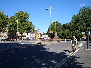
Banbury Road is a major arterial road in Oxford, England, running from St Giles' at the south end, north towards Banbury through the leafy suburb of North Oxford and Summertown, with its local shopping centre. Parallel and to the west is the Woodstock Road, which it meets at the junction with St Giles'. To the north, Banbury Road meets the Oxford Ring Road at a roundabout. The road is designated the A4165. Prior to the building of the M40 motorway extension in 1990, the road formed part of the A423 from Maidenhead to Coventry.

Summertown in North Oxford is a suburb of Oxford, England. Summertown is a one-mile square residential area, north of St Giles, the boulevard leading out of Oxford's city centre. Summertown is home to several independent schools and the city's most expensive houses. On both sides of Banbury Road are Summertown's popular shops. There is also a smaller street of shops and restaurants, South Parade, that links Banbury Road and Woodstock Road. Summertown is home to much of Oxford's broadcast media. BBC Radio Oxford and the BBC Television's Oxford studios are on Banbury Road. Start-ups also have an increasing presence on the parade, such as Brainomix and Passle. The studios for JACK FM, Glide FM, and Six TV Oxford are on Woodstock Road.
St Giles' is a wide boulevard leading north from the centre of Oxford, England. At its northern end, the road divides into Woodstock Road to the left and Banbury Road to the right, both major roads through North Oxford. At the southern end, the road continues as Magdalen Street at the junction with Beaumont Street to the west. Also to the west halfway along the street is Pusey Street. Like the rest of North Oxford, much of St Giles' is owned by St John's College.
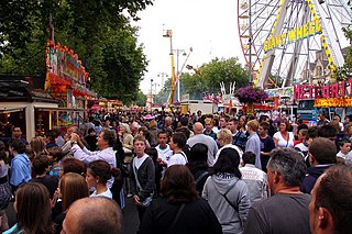
St Giles' Fair is an annual fair held in St Giles', a wide thoroughfare in central north Oxford, England. The origins of the fair can be traced back to medieval times where it became one of England's dynamic trading centers. The fair has survived medieval times and is organised for a two-day duration in September each year by the Oxford City Council with the London and Home Counties section of the Showmen's Guild of Great Britain.

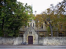
The Oxford Centre for Mission Studies (OCMS) is in the former SS Philip and James Parish Church on Woodstock Road, Oxford, England, opposite Leckford Road. It was established in 1983.

Magdalen Street is a short shopping street in central Oxford, England, just north of the original north gate in the city walls. Traditionally, the name of the street is pronounced and not as the name of the Magdalen College, which is always.

Walton Street is on the eastern edge of the Jericho district of central Oxford, England.

Bevington Road is a residential road in central North Oxford, England.

St Margaret's Road is a road in North Oxford, England.
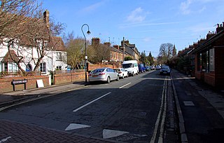
Leckford Road is a road in North Oxford, England. It runs between Kingston Road to the west and Woodstock Road to the east.
Margaret Jean Redcliffe-Maud, Baroness Redcliffe-Maud was a British pianist.

St. Giles' Church is a church in North Oxford, England. It is at the northern end of the wide thoroughfare of St Giles', at the point where it meets Woodstock Road and Banbury Road. It stands between where Little Clarendon Street joins Woodstock Road and Keble Road joins Banbury Road.

Moreton Road is a residential road in the Oxford suburb of North Oxford, Oxfordshire, United Kingdom.

Staverton Road is a residential road in North Oxford, England.

St Bernard's Road is a residential road in North Oxford, England, connecting the southern end of Kingston Road and the northern end of Walton Street, at the junction with Walton Well Road, to the west with Woodstock Road, opposite Bevington Road, to the east.