
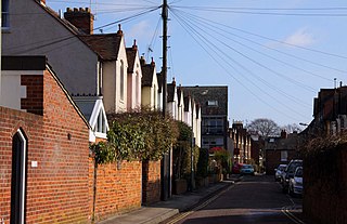
Staverton Road is a residential road in North Oxford, England.
Staverton Road is a residential road in North Oxford, England.
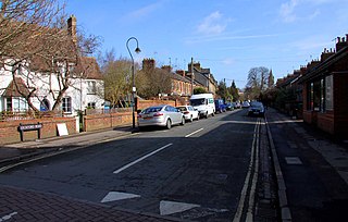
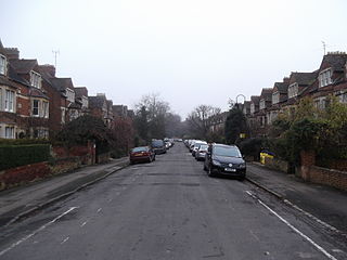
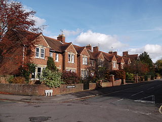
The road runs east–west with a gentle curve halfway along. [1] At the western end of the road is a junction with Woodstock Road (A4144) and at the eastern end is a junction with Banbury Road (A4165), the two major arterial roads out of Oxford to the north. Opposite slightly to the north at the western end is Frenchay Road. Opposite slightly to the south at the eastern end is Belbroughton Road. Parallel to the south is Rawlinson Road and to the north is Lathbury Road. It forms the approximate northern boundary of the original North Oxford development by St John's College, Oxford, along with Frenchay Road to the west and Marston Ferry Road to the east. [2]


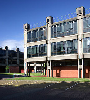
"Stavertonia" (aka Stavs and formerly Stavers), or the University College Annexe, a student accommodation complex of buildings for University College, Oxford, is located south of the road, [3] largely built from 1967. [4] The new buildings were designed by the University College alumnus Sir Philip Dowson of Arup Associates. [5] Staverton House, at 104 Woodstock Road close to Staverton Road, was bought by University College in 1953 and converted into flats. [6] Lord Beveridge (1878–1963), Master of University College from 1937–45, rented one of the flats for a while. The site includes Redcliffe-Maud House (formerly 100A Woodstock Road, built in the garden of 100 Woodstock Road), named after a former Master of University College at the time of the development of Stavertonia, Lord Redcliffe-Maud.
As of 2022 [update] , the Stavertonia site is being further extended and developed to become Univ North (formally University College, North Oxford [7] ), stretching all the way to Banbury Road, expanding the existing 12,000 m2 site by 8,000 m2. [8]
Trinity College, Oxford has an annexe on the north corner of Staverton Road with Woodstock Road, providing accommodation for over 70 members of the college. [9] It was built in 1979 to a design by the architect Simon Shew of Grey and Baynes. [10]


The Danish-Irish astronomer John Louis Emil Dreyer (1852–1926) lived at 14 Staverton Road from 30 September 1916 onwards with his wife Kate. [11] While in Oxford, he worked on his 15-volume edited collection of the works of the Danish astronomer Tycho Brahe. [12] On 14 September 1926, Dreyer died at his home in Staverton Road.
England's first woman barrister and tutor at St Anne's College, Ivy Williams, lived at 30 Staverton Road until her death in 1966.[ citation needed ]
The theologian and bishop within the Eastern Orthodox Church, Kallistos Ware (born Timothy Ware, 1934), lived with his parents at 15 Staverton Road. [13]
Other residents include the ecological economist Stanislav Edward Shmelev, [14] Sir William D. M. Paton FRS (1917–1993), winner of the Gairdner Foundation International Award in 1959 and Professor of Pharmacology at the University of Oxford, and the solid-state physicist H. M. Rosenberg. [15]
The fictional character George Papadimitriou called a meeting of the Oakley Street resistance group at 28 Staverton Road in Philip Pullman’s The Book of Dust , Volume One, "La Belle Sauvage", chapter 13. [16]

North Oxford is a suburban part of the city of Oxford in England. It was owned for many centuries largely by St John's College, Oxford and many of the area's Victorian houses were initially sold on leasehold by the College.

Banbury Road is a major arterial road in Oxford, England, running from St Giles' at the south end, north towards Banbury through the leafy suburb of North Oxford and Summertown, with its local shopping centre. Parallel and to the west is the Woodstock Road, which it meets at the junction with St Giles'. To the north, Banbury Road meets the Oxford Ring Road at a roundabout. The road is designated the A4165. Prior to the building of the M40 motorway extension in 1990, the road formed part of the A423 from Maidenhead to Coventry.

Woodstock Road is a major road in Oxford, England, running from St Giles' in the south, north towards Woodstock through the leafy suburb of North Oxford. To the east is Banbury Road, which it meets at the junction with St Giles'.

Linton Road is a road in North Oxford, England.
Leckford Road is a road in North Oxford, England. It runs between Kingston Road to the west and Woodstock Road to the east.
Sir Philip Henry Manning Dowson was a leading British architect. He served as President of the Royal Academy from 1993 to 1999.
Walton Manor is a residential suburb in Oxford, England. It is north of Jericho and the Radcliffe Observatory Quarter and forms part of North Oxford. The street layout and many of the area's buildings date from the mid-19th century. It was developed on land belonging to St John's College, Oxford.

The Norham Manor estate is a residential suburb in Oxford, England. It is part of central North Oxford. To the north is Park Town with its crescents, to the east is the River Cherwell, to the south are the University Parks and to the west is Walton Manor, on the other side of Banbury Road.
Chalfont Road is a road in Walton Manor, north Oxford, England.

Lathbury Road is a short residential road in north Oxford, England.

Rawlinson Road is a residential road in North Oxford, England.
Frenchay Road is a residential road in Walton Manor, North Oxford, England.

Observatory Street links at the eastern end Woodstock Road in central North Oxford and at the western end Walton Street and the Jericho area of Oxford, England.
Plantation Road is a residential road in North Oxford, England, connecting Kingston Road to the west with Woodstock Road to the east.
Garford Road is a residential road in North Oxford, England.

St Bernard's Road is a residential road in North Oxford, England, connecting the southern end of Kingston Road and the northern end of Walton Street, at the junction with Walton Well Road, to the west with Woodstock Road, opposite Bevington Road, to the east.

Hayfield Road is a residential road that runs north-south in Walton Manor, north Oxford, England.
Bradmore Road is a residential road in North Oxford, England.

Warnborough Road is a residential road in North Oxford, England.
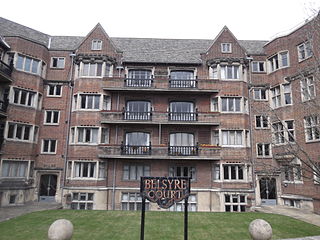
Belsyre Court is a listed early 20th-century block of flats in Oxford, England.