Yell is one of the North Isles of Shetland, Scotland. In the 2011 census it had a usually resident population of 966. It is the second largest island in Shetland after the Mainland with an area of 82 square miles (212 km2), and is the third most populous in the archipelago, after the Mainland and Whalsay.

The Northern Isles are a chain of islands off the north coast of mainland Scotland. The climate is cool and temperate and highly influenced by the surrounding seas. There are two main island groups: Shetland and Orkney. There are a total of 36 inhabited islands, with the fertile agricultural islands of Orkney contrasting with the more rugged Shetland islands to the north, where the economy is more dependent on fishing and the oil wealth of the surrounding seas. Both archipelagos have a developing renewable energy industry. They share a common Pictish and Norse history, and were part of the Kingdom of Norway before being absorbed into the Kingdom of Scotland in the 15th century. The islands played a significant naval role during the world wars of the 20th century.
Celtic art is associated with the peoples known as Celts; those who spoke the Celtic languages in Europe from pre-history through to the modern period, as well as the art of ancient peoples whose language is uncertain, but have cultural and stylistic similarities with speakers of Celtic languages.

The Scalloway Islands are in Shetland opposite Scalloway on south west of the Mainland. They form a mini-archipelago and include:

Dunrossness, is the southernmost parish of Shetland, Scotland. Historically the name Dunrossness has usually referred to the area on the Shetland mainland south of Quarff. However, in 2016 there were three separate Shetland Community Councils for a) Gulberwick, Quarff and Cunningsburgh; b) Sandwick; and c) Dunrossness. The 2011 census defined Dunrossness as including everybody within the British ZE2 postal code, which goes as far north as Gulberwick. It has the best and largest area of fertile farmland of any parish in Shetland. Dunrossness includes the island of Mousa, Levenwick, St Ninian's Isle, Bigton, Scousburgh, the Lochs of Spiggie and Brow, Boddam, Quendale, Virkie, Exnaboe, Grutness, Toab, Ness of Burgi, Clumlie Broch, Scatness, Sumburgh Airport, Sumburgh Head, West Voe, the islands of Lady's Holm, Little Holm, Horse Holm island and Fair Isle.

An ayre is the name used for shingle beaches found in Orkney, Shetland, the Isle of Man, Lancashire, Cumbria and Northumbria. The word is derived from the Old Norse eyrr, meaning a shingle beach or gravelly place, and may be applied to ordinary beaches, cliff-foot beaches such as the Lang Ayre in Northmavine, Shetland, spits, bars or tombolos, but only if formed of shingle. More than 130 such shingle beaches are named on Ordnance Survey maps of Shetland, but far fewer in Orkney, where most beaches are formed of sand. The word in its Old Norse form is common in Iceland, and it also occurs in a few place names in the north and west of the Scottish mainland which had a strong Norse influence, such as Eriboll and in the names of several shingle banks—Salt Ayre, Green Ayre, Stake Ayre, Rabbit Ayre and Whinny Ayre—in the tidal reach of the River Lune at Lancaster.
Sandsting is a parish in the West Mainland of Shetland, Scotland, forming a southern arm of the Walls Peninsula. After the parish of Aithsting was annexed into Sandsting in the sixteenth century, it became known as Sandsting and Aithsting parish.

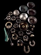
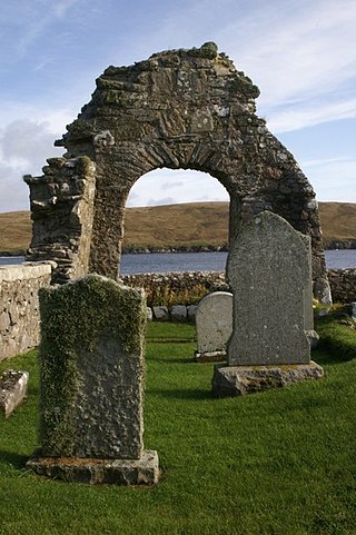
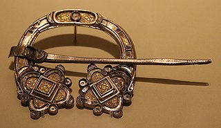
The St Ninian's Isle Treasure, found on St Ninian's Isle, Scotland in 1958 is the best example of surviving silver metalwork from the Early Medieval period in Scotland. The 28-piece hoard includes various silver metalwork items, including twelve pennanular brooches. The treasure is now in the National Museum of Scotland.
Geopark Shetland is the name used by the Geopark formally established in September 2009 on its entry into the European Geoparks Network. The Geopark extends across the entire Shetland archipelago off the north coast of mainland Scotland. It is administered by the Shetland Amenity Trust in partnership with organisations such as Scottish Natural Heritage, the Shetland Islands Council, Highlands and Islands Enterprise and various community and tourism associations.
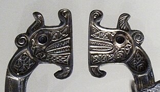
The Celtic brooch, more properly called the penannular brooch, and its closely related type, the pseudo-penannular brooch, are types of brooch clothes fasteners, often rather large; penannular means formed as an incomplete ring. They are especially associated with the beginning of the Early Medieval period in Ireland and Britain, although they are found in other times and places—for example, forming part of traditional female dress in areas in modern North Africa.
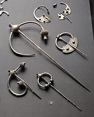
The Penrith Hoard is a dispersed hoard of 10th century silver penannular brooches found at Flusco Pike, Newbiggin Moor, near Penrith in Cumbria, and now in the British Museum in London. The largest "thistle brooch" was discovered in 1785 and another in 1830, with the bulk of items being recovered in two groups close to each other by archaeologists in 1989. Whether all the finds made close to each other were originally deposited at the same time remains uncertain, but it is thought likely that at least the brooches were. The brooches are thought to have been deposited in about 930.

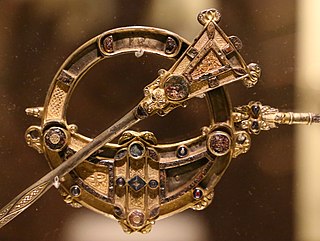
The Hunterston Brooch is a highly important Celtic brooch of "pseudo-penannular" type found near Hunterston, North Ayrshire, Scotland, in either, according to one account, 1826 by two men from West Kilbride, who were digging drains at the foot of Goldenberry Hill, or in 1830. It is now in the National Museum of Scotland, Edinburgh. Made within a few decades of 700 AD, the Hunterston Brooch is cast in silver, gilt, and set with pieces of amber, and decorated with interlaced animal bodies in gold filigree. The diameter of the ring is 12.2 cm, and in its centre there is a cross and a golden glory representing the risen Christ, surrounded by tiny bird heads. The pin, which is broken, can travel freely around the ring as far as the terminals, which was necessary for fastening; it is now 13.1 cm long, but was probably originally 15 cm or more.
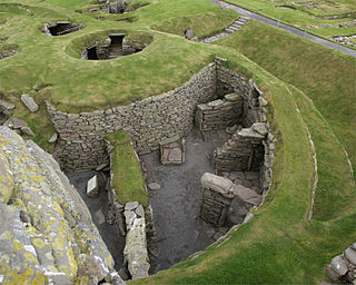
Prehistoric Shetland refers to the prehistoric period of the Shetland archipelago of Scotland, when it was first occupied by humans. The period prior to human settlement in Shetland is known as the geology of Scotland. Prehistory in Shetland does not end until the beginning of the Early Medieval Period in Scotland, around AD 600. More than 5,000 archaeological sites have been recorded in the Shetland Islands.

In the early Middle Ages, there were distinct material cultures evident in the different federations and kingdoms within what is now Scotland. Pictish art was the only uniquely Scottish medieval style; it can be seen in the extensive survival of carved stones, particularly in the north and east of the country, which hold a variety of recurring images and patterns. It can also be seen in elaborate metal work that largely survives in buried hoards. Irish-Scots art from the kingdom of Dál Riata suggests that it was one of the places, as a crossroads between cultures, where the Insular style developed.

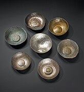
Norrie's Law hoard is a sixth century silver hoard discovered in 1819 at a small mound in Largo, Fife, Scotland. Found by an unknown person or persons, most of the hoard was illegally sold or given away, and has disappeared. Remaining items of the hoard were found later at the mound, and were turned over to the landowner, General Philip Durham. The surviving 170 pieces from the hoard are now in the National Museum of Scotland. The treasure consists mostly of hacksilver and includes four complete silver pieces. Both Roman and much rarer Pictish objects are among the survivals.

Scottish jewellery is jewellery created in Scotland or in a style associated with Scotland, which today often takes the form of the Celtic style. It is often characterised by being inspired by nature, Scandinavian mythology, and Celtic knot patterns. Jewellery has a history in Scotland dating back to at least the Iron Age.
The Kilmainham Brooch is a late 8th- or early 9th-century Celtic brooch of the "penannular" type. With a diameter of 9.67 cm, it is a relatively large example, and is made from silver, gold and glass, with filigree and interlace decorations. Like other high-quality brooches of its class, it was probably intended to fasten copes and other vestments rather than for everyday wear, as its precious metal content would have made it a status symbol for its owner; less expensive Viking-style brooches were typically worn in pairs on women's clothing.

The Rogart Brooch is a large penannular brooch of Pictish origin, dated to the eighth century. Characteristic of contemporary Pictish brooches, it contains three-dimensional bird-head inserts formed with glass.