
Orkney, also known as the Orkney Islands, is an archipelago in the Northern Isles of Scotland, situated off the north coast of the island of Great Britain. Orkney is 10 miles (16 km) north of the coast of Caithness and has about 70 islands, of which 20 are inhabited. The largest island, the Mainland, has an area of 523 square kilometres (202 sq mi), making it the sixth-largest Scottish island and the tenth-largest island in the British Isles. Orkney’s largest settlement, and also its administrative centre, is Kirkwall.
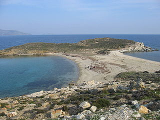
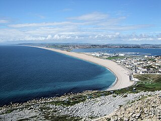
A tombolo is a sandy isthmus. A tombolo, from the Italian tombolo, meaning 'pillow' or 'cushion', and sometimes translated as ayre, is a deposition landform by which an island becomes attached to the mainland by a narrow piece of land such as a spit or bar. Once attached, the island is then known as a tied island.

In oceanography, geomorphology, and geoscience, a shoal is a natural submerged ridge, bank, or bar that consists of, or is covered by, sand or other unconsolidated material and rises from the bed of a body of water to near the surface. It often refers to those submerged ridges, banks, or bars that rise near enough to the surface of a body of water as to constitute a danger to navigation. Shoals are also known as sandbanks, sandbars, or gravelbars. Two or more shoals that are either separated by shared troughs or interconnected by past or present sedimentary and hydrographic processes are referred to as a shoal complex.

A spit or sandspit is a deposition bar or beach landform off coasts or lake shores. It develops in places where re-entrance occurs, such as at a cove's headlands, by the process of longshore drift by longshore currents. The drift occurs due to waves meeting the beach at an oblique angle, moving sediment down the beach in a zigzag pattern. This is complemented by longshore currents, which further transport sediment through the water alongside the beach. These currents are caused by the same waves that cause the drift.

West Burra is one of the Scalloway Islands, a subgroup of the Shetland Islands in Scotland. It is connected by bridge to East Burra. With an area of 743 hectares, it is the eleventh-largest of the Shetland Islands.

The Northern Isles are a pair of archipelagos off the north coast of mainland Scotland, comprising Orkney and Shetland. They are part of Scotland, as are the Hebrides. The climate is cool and temperate and much influenced by the surrounding seas. There are a total of 36 inhabited islands. The landscapes of the fertile agricultural islands of Orkney contrast with the more rugged Shetland islands to the north, where the economy is more dependent on fishing and on the oil wealth of the surrounding seas. Both island groups have a developing renewable energy industry. Both have a Pictish and Norse history. Both were part of the Kingdom of Norway until they were absorbed into the Kingdom of Scotland in the 15th century. They remained part of it until the 1707 formation of the Kingdom of Great Britain and the 1801 formation of the United Kingdom. And they both played a significant naval role during the world wars of the 20th century.
St Ninian's Isle is a small tied island connected by the largest tombolo in the UK to the south-western coast of the Mainland, Shetland, in Scotland. It is part of the civil parish of Dunrossness on the South Mainland. The tombolo, known locally as an ayre from the Old Norse for "gravel bank", is 500 metres long. During the summer the tombolo is above sea level and accessible to walkers. During winter, stronger wave action removes sand from the beach so that it is usually covered at high tide, and occasionally throughout the tidal cycle, until the sand is returned the following spring. Depending on the definition used, St. Ninian's is thus either an island, or a peninsula; it has an area of about 72 hectares.

Coastal geography is the study of the constantly changing region between the ocean and the land, incorporating both the physical geography and the human geography of the coast. It includes understanding coastal weathering processes, particularly wave action, sediment movement and weather, and the ways in which humans interact with the coast
A storm beach is a beach affected by particularly fierce waves, usually with a very long fetch. The resultant landform is often a very steep beach composed of rounded cobbles, shingle and occasionally sand. The stones usually have an obvious grading of pebbles, from large to small, with the larger diameter stones typically arrayed at the highest beach elevations. It may also contain many small parts of shipwrecked boats.

The Point of Ayre is the northernmost point of the Isle of Man. It lies at the northern end of Ramsey Bay 6 miles (10 km) north of the town of Ramsey. The point can be accessed by the A16 road from Bride. Point of Ayre lighthouse, the oldest lighthouse on the Isle of Man, is located here.

Ayre is one of the six sheadings of the Isle of Man.

Cuspate forelands, also known as cuspate barriers or nesses in Britain, are geographical features found on coastlines and lakeshores that are created primarily by longshore drift. Formed by accretion and progradation of sand and shingle, they extend outwards from the shoreline in a triangular shape.

South Walls, often referred to as Walls, is an inhabited island adjacent to Hoy in Orkney, Scotland. The name is a corruption of "Sooth Was", which means the "southern voes" – as with Kirkwall, it was assumed that it was a mispronunciation of "walls".

Tied islands, or land-tied islands as they are often known, are landforms consisting of an island that is connected to mainland or another island only by a tombolo: a spit of beach materials connected to land at both ends. St Ninian's Isle in the Shetland Islands off the north coast of Scotland is an example of this; it was once an island but is now linked to the Mainland. Other examples include: Maury Island, Washington in the Puget Sound, Coronado, California and Nahant, Massachusetts in the U.S.; Barrenjoey, New South Wales in Australia; Howth Head in Ireland; Wedge Island in Western Australia; Cheung Chau in Hong Kong and Davaar Island, Campbeltown, Scotland.
Tankerness is a district in the St Andrews parish in Mainland, Orkney, Scotland. Essentially a peninsula, it is about 13 kilometres (8 mi) south-east of Kirkwall and 1 kilometre (0.6 mi) east of Kirkwall Airport. The origin of the place name is uncertain, but it may derive from the Norse personal name "Tannskári". A "ness" is a promontory.

The modern names of Scottish islands stem from two main influences. There are many names that derive from the Scottish Gaelic language in the Hebrides and Firth of Clyde. In the Northern Isles most place names have a Norse origin. There are also some island place names that originate from three other influences, including a limited number that are essentially English language names, a few that are of Brittonic origin and some of an unknown origin that may represent a pre-Celtic language. These islands have all been occupied by the speakers of at least three and in many cases four or more languages since the Iron Age, and many of the names of these islands have more than one possible meaning as a result.

St Magnus Bay is a large coastal feature in the north-west of Mainland Shetland, Scotland. Roughly circular in shape with a diameter of about 19 kilometres (12 mi), it is open to the North Atlantic Ocean to the west. The indented coastline to the north, south and east between Esha Ness in the north and the Ness of Melby in the south contains numerous bays, firths and voes and there are several islands around the perimeter. The waters of the bay are up to 165 metres (541 ft) deep and may have been the site of a substantial meteor impact.
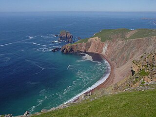
The Lang Ayre is a beach on the west side of Ronas Hill, Northmavine, Shetland. At 1 kilometre (0.6 mi) in length it is the archipelago's longest. It is accessed either by a long walk from the top of Collafirth Hill down the Burn of Monius, or by sea. The beach's sand is red, eroded from the up to 700 feet (210 m) high red granite cliffs towering above it.


