The Dardanelles, also known as the Strait of Gallipoli and in Classical Antiquity as the Hellespont, is a narrow, natural strait and internationally significant waterway in northwestern Turkey that forms part of the continental boundary between Asia and Europe and separates Asian Turkey from European Turkey. Together with the Bosporus, the Dardanelles forms the Turkish Straits.

The Strait of Gibraltar is a narrow strait that connects the Atlantic Ocean to the Mediterranean Sea and separates Europe from Africa. The two continents are separated by 13 kilometres of ocean at the Strait's narrowest point between Punta de Tarifa in Spain and Point Cires in Morocco. Ferries cross between the two continents every day in as little as 35 minutes. The Strait's depth ranges between 300 and 900 metres.

Malacca Strait is a narrow stretch of water, 500 mi long and from 40 to 155 mi wide, located between the Indonesian island of Sumatra to the southwest and the Malay Peninsula to the northeast, connecting the Andaman Sea with the Singapore Strait and the South China Sea. As the main shipping channel between the Indian Ocean and the South China Sea, it is one of the most important shipping lanes in the world. It is named after the Phyllanthus emblica, which is known by the locals as the Malaka tree, grown in coastal regions alongside the strait.

The Bab-el-Mandeb, the Gate of Grief or the Gate of Tears, is a strait between Yemen on the Arabian Peninsula and Djibouti and Eritrea in the Horn of Africa. It connects the Red Sea to the Gulf of Aden and by extension the Indian Ocean.
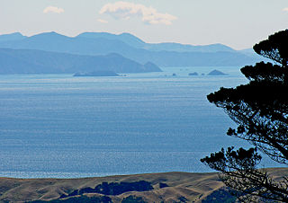
Cook Strait separates the North and South Islands of New Zealand. The strait connects the Tasman Sea on the northwest with the South Pacific Ocean on the southeast. It is 22 kilometres (14 mi) wide at its narrowest point, and is considered one of the most dangerous and unpredictable waters in the world. Regular ferry services run across the strait between Picton in the Marlborough Sounds and Wellington.
Firth is a word in the English and Scots languages used to denote various coastal waters in the United Kingdom, predominantly within Scotland. In the Northern Isles, it more often refers to a smaller inlet. It is linguistically cognate to fjord, which has a more constrained sense in English. Bodies of water named "firths" tend to be more common on the Scottish east coast, or in the southwest of the country, although the Firth of Clyde is an exception to this. The Highland coast contains numerous estuaries, straits, and inlets of a similar kind, but not called "firth" ; instead, these are often called sea lochs. Before about 1850, the spelling "Frith" was more common.

An isthmus is a narrow piece of land connecting two larger areas across an expanse of water by which they are otherwise separated. A tombolo is an isthmus that consists of a spit or bar, and a strait is the sea counterpart of an isthmus, a narrow stretch of sea between two landmasses that connects two larger bodies of water.

The Strait of Dover or Dover Strait, is the strait at the narrowest part of the English Channel, marking the boundary between the Channel and the North Sea, and separating Great Britain from continental Europe. The shortest distance across the strait, at approximately 20 miles, is from the South Foreland, northeast of Dover in the English county of Kent, to Cap Gris Nez, a cape near to Calais in the French département of Pas-de-Calais. Between these points lies the most popular route for cross-channel swimmers. The entire strait is within the territorial waters of France and the United Kingdom, but a right of transit passage under the United Nations Convention on the Law of the Sea allows vessels of other nations to move freely through the strait.

The Pentland Firth is a strait which separates the Orkney Islands from Caithness in the north of Scotland. Despite the name, it is not a firth.

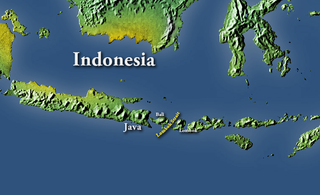
The Sunda Strait is the strait between the Indonesian islands of Java and Sumatra. It connects the Java Sea with the Indian Ocean.
The Lombok Strait, is a strait of the Bali Sea connecting to the Indian Ocean, and is located between the islands of Bali and Lombok in Indonesia. The Gili Islands are on the Lombok side.
Landforms are categorized by characteristic physical attributes such as their creating process, shape, elevation, slope, orientation, rock exposure, and soil type.

The Mona Passage is a strait that separates the islands of Hispaniola and Puerto Rico. The Mona Passage connects the Atlantic Ocean to the Caribbean Sea and is an important shipping route between the Atlantic and the Panama Canal.

Wetar Strait is an international strait in Southeast Asia. It separates the island of Wetar from the eastern part of the island of Timor. The strait is also the eastern portion of a pair of international straits, the other one being Ombai Strait; the two straits combine to link the Indian Ocean with the Pacific Ocean.
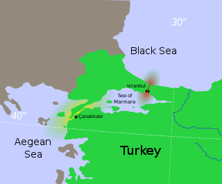
The Turkish Straits are two internationally significant waterways in northwestern Turkey. The Straits create a series of international passages that connect the Aegean and Mediterranean seas to the Black Sea. They consist of the Dardanelles and the Bosphorus. The straits are on opposite ends of the Sea of Marmara. The straits and the Sea of Marmara are part of the sovereign sea territory of Turkey and are treated as Turkish internal waters.

The following outline is provided as an overview of and introduction to Oceanography.

New Zealand has large ocean energy resources but does not yet generate any power from them. TVNZ reported in 2007 that over 20 wave and tidal power projects are currently under development. However, not a lot of public information is available about these projects. The Aotearoa Wave and Tidal Energy Association was established in 2006 to "promote the uptake of marine energy in New Zealand". According to their 10 February 2008 newsletter, they have 59 members. However, the association doesn't list its members.
Transit passage is a concept of the law of the sea, which allows a vessel or aircraft the freedom of navigation or overflight solely for the purpose of continuous and expeditious transit of a strait between one part of the high seas or exclusive economic zone and another. The requirement of continuous and expeditious transit does not preclude passage through the strait for the purpose of entering, leaving or returning from a state bordering the strait, subject to the conditions of entry to that state. The transit passage may be exercised regardless of the nationality (flag) of the ship, its form of ownership, the merchant or government status of a ship or warship, the private or government status of an aircraft.

A tidal stream generator, often referred to as a tidal energy converter (TEC), is a machine that extracts energy from moving masses of water, in particular tides, although the term is often used in reference to machines designed to extract energy from the run of a river or tidal estuarine sites. Certain types of these machines function very much like underwater wind turbines and are thus often referred to as tidal turbines. They were first conceived in the 1970s during the oil crisis.

A gat is a strait that is constantly eroded by currents flowing back and forth, such as tidal currents. It is usually a relatively narrow but deep, up to 30 m (100 ft) passage between land masses or shallow bars in an area of mudflats. A gat is sometimes a shallower passage on lagoon coasts, including those without any tidal range.