Strait of Gibraltar

Last updated
Strait of Gibraltar
STS059-238-074 Strait of Gibraltar.jpg
The Strait of Gibraltar as seen from space.
The Iberian Peninsula is on the left and North Africa is on the right.
North Atlantic Ocean laea relief location map.jpg
Red pog.svg
Strait of Gibraltar
Location of the Strait of Gibraltar between Africa (centre right) and Europe (top right), connecting the Atlantic Ocean in the centre to the Mediterranean Sea on the right
Location Atlantic Ocean   Mediterranean Sea
Coordinates 35°58′N5°29′W / 35.967°N 5.483°W / 35.967; -5.483
Type Strait
Basin  countries
Min. width13 km (8.1 mi)
Max. depth900 metres (2,953 ft)

The Strait of Gibraltar [1] is a narrow strait that connects the Atlantic Ocean to the Mediterranean Sea and separates Europe from Africa. The two continents are separated by 13 kilometres (8.1 miles ; 7.0 nautical miles ) of ocean at the Strait's narrowest point between Punta de Tarifa in Spain and Point Cires in Morocco. [2] Ferries cross between the two continents every day in as little as 35 minutes. The Strait's depth ranges between 300 and 900 metres (980 and 2,950 feet ; 160 and 490 fathoms ). [3]

Contents

The strait lies in the territorial waters of Morocco, Spain, and the British overseas territory of Gibraltar. Under the United Nations Convention on the Law of the Sea, foreign vessels and aircraft have the freedom of navigation and overflight to cross the strait of Gibraltar in case of continuous transit.

Names and etymology

The name comes from the Rock of Gibraltar, which in turn originates from the Arabic Jabal Ṭāriq (meaning "Tariq's Mount"), [4] named after Tariq ibn Ziyad. It is also known as the Straits of Gibraltar, the Gut of Gibraltar (although this is mostly archaic), [5] the STROG (STRait Of Gibraltar) in naval use. [6]

Another Arabic name is Bāb al-maghrib (Arabic: باب المغرب), meaning "Gate of the West" or "Gate of the sunset", and furthermore "Gate of the Maghreb" or "Gate of Morocco [ broken anchor ]".[ citation needed ] In the Middle Ages it was called in Arabic Az-Zuqāq (الزقاق), "the Passage" and by the Romans Fretum Gaditanum (Strait of Cadiz). [7]

In Latin it has been called Fretum Herculeum, [8] based on the name from antiquity "Pillars of Hercules" (Ancient Greek : αἱ Ἡράκλειοι στῆλαι, romanized: hai Hērákleioi stêlai), [9] referring to the mountains as pillars, such as Gibraltar, flanking the strait.

Location

Europe (left) and Africa (right) The Strait of Gibraltar, April 2023.jpg
Europe (left) and Africa (right)

On the northern side of the Strait are Spain and Gibraltar (a British overseas territory in the Iberian Peninsula). On the southern side are Morocco and Ceuta (a Spanish autonomous city in northern Africa).

Due to its location, the Strait is commonly used for illegal immigration from Africa to Europe. [10]

Extent

The International Hydrographic Organization defines the limits of the Strait of Gibraltar as follows: [11]

Geology

A view across the Strait of Gibraltar taken from the hills above Tarifa, Spain StraitOfGibraltar.JPG
A view across the Strait of Gibraltar taken from the hills above Tarifa, Spain

The seabed of the Strait is composed of synorogenic Betic-Rif clayey flysch covered by Pliocene and/or Quaternary calcareous sediments, sourced from thriving cold water coral communities. [12] Exposed bedrock surfaces, coarse sediments and local sand dunes attest to the strong bottom current conditions at the present time.[ citation needed ]

Around 5.9 million years ago, the connection between the Mediterranean Sea and the Atlantic Ocean along the Betic and Rifan Corridor was progressively restricted until its total closure, effectively causing the salinity of the Mediterranean to rise periodically within the gypsum and salt deposition range, during what is known as the Messinian salinity crisis. In this water chemistry environment, dissolved mineral concentrations, temperature and stilled water currents combined and occurred regularly to precipitate many mineral salts in layers on the seabed. The resultant accumulation of various huge salt and mineral deposits about the Mediterranean basin are directly linked to this era. It is believed that this process took a short time, by geological standards, lasting between 500,000 and 600,000 years.[ citation needed ]

It is estimated that, were the Strait closed even at today's higher sea level, most water in the Mediterranean basin would evaporate within only a thousand years, as it is believed to have done then, and such an event would lay down mineral deposits like the salt deposits now found under the sea floor all over the Mediterranean.[ citation needed ]

After a lengthy period of restricted intermittent or no water exchange between the Atlantic Ocean and Mediterranean basin, approximately 5.33 million years ago, [13] the Atlantic–Mediterranean connection was completely reestablished through the Strait of Gibraltar by the Zanclean flood, and has remained open ever since. [14] The erosion produced by the incoming waters seems to be the main cause for the present depth of the Strait (900 m (3,000 ft; 490 fathoms) at the narrows, 280 m (920 ft; 150 fathoms) at the Camarinal Sill). The Strait is expected to close again as the African Plate moves northward relative to the Eurasian Plate, [15] but on geological rather than human timescales.

Biodiversity

The Strait has been identified as an Important Bird Area by BirdLife International because of the hundreds of thousands of seabirds which use it every year to migrate between the Mediterranean and the Atlantic, including significant numbers of Scopoli's and Balearic shearwaters, Audouin's and lesser black-backed gulls, razorbills, and Atlantic puffins. [16]

A resident orca pod of some 36 individuals lives around the Strait, one of the few that are left in Western European waters. The pod may be facing extinction in the coming decades due to long term effects of PCB pollution. [17]

History

Historic map of the Strait of Gibraltar by Piri Reis Strait of Gibraltar by Piri Reis.jpg
Historic map of the Strait of Gibraltar by Piri Reis

Evidence of the first human habitation of the area by Neanderthals dates back to 125,000 years ago. It is believed that the Rock of Gibraltar may have been one of the last outposts of Neanderthal habitation in the world, with evidence of their presence there dating to as recently as 24,000 years ago. [18] Archaeological evidence of Homo sapiens habitation of the area dates back c.40,000 years.

The relatively short distance between the two shores has served as a quick crossing point for various groups and civilizations throughout history, including Carthaginians campaigning against Rome, Romans travelling between the provinces of Hispania and Mauritania, Vandals raiding south from Germania through Western Rome and into North Africa in the 5th century, Moors and Berbers in the 8th–11th centuries, and Spain and Portugal in the 16th century.

Beginning in 1492, the Strait began to play a certain cultural role in acting as a barrier against cross-channel conquest and the flow of culture and language that would naturally follow such a conquest. In that year, the last Muslim government north of the Strait was overthrown by a Spanish force. Since that time, the Strait has come to foster the development of two very distinct and varied cultures on either side of it after sharing much the same culture for over 500 years from the 8th century to the early 13th century.[ citation needed ]

On the northern side, Christian-European culture has remained dominant since the expulsion of the last Muslim kingdom in 1492, along with the Romance Spanish language, while on the southern side, Muslim-Arabic/Mediterranean has been dominant since the spread of Islam into North Africa in the 700s, along with the Arabic language.

The small British enclave of the city of Gibraltar presents a third cultural group found in the Strait. This enclave was first established in 1704 and has since been used by the United Kingdom to act as a surety for control of the sea lanes into and out of the Mediterranean.

Following the Spanish coup of July 1936 the Spanish Republican Navy tried to blockade the Strait of Gibraltar to hamper the transport of Army of Africa troops from Spanish Morocco to Peninsular Spain. On 5 August 1936 the so-called Convoy de la victoria was able to bring at least 2,500 men across the Strait, breaking the republican blockade. [19]

Communications

3-D rendering, looking eastwards towards the Mediterranean Hercules3D.jpg
3-D rendering, looking eastwards towards the Mediterranean

The Strait is an important shipping route from the Mediterranean to the Atlantic. Ferries operate between Spain and Morocco across the Strait, as well as between Spain and Ceuta and Gibraltar to Tangier.

Tunnel across the Strait

Discussion between Spain and Morocco of a tunnel under the strait began in the 1980s. In December 2003, both countries agreed to explore the construction of an undersea rail tunnel to connect their rail systems across the Strait. The gauge of the rail would be 1,435 mm (4 ft 8+12 in) to match the proposed construction and conversion of significant parts of the existing broad gauge system to standard gauge. [20] While the project remained in a planning phase, Spanish and Moroccan officials met to discuss it occasionally, including in 2012. [21] Those talks led to nothing constructive happening, but in April 2021 ministers from both countries agreed to a joint intergovernmental meeting to be held in Casablanca in the coming months. This was in order to resume discussions on a tunnel. [22] [23] Earlier, in January 2021, the UK government had studied plans for a tunnel to link Gibraltar with Tangiers that would replace the Spanish-Moroccan project that until then had had no tangible results after over 40 years of discussions. [24]

Special flow and wave patterns

The Strait of Gibraltar links the Atlantic Ocean directly to the Mediterranean Sea. This direct linkage creates certain unique flow and wave patterns. These unique patterns are created due to the interaction of various regional and global evaporative forces, water temperatures, tidal forces, and wind forces.

Inflow and outflow

The Strait of Gibraltar with the Mediterranean Sea in upper right. Internal waves (marked with arrows) are caused by water flowing through the Strait (bottom left, top right). InternalWaves Gibraltar ISS009-E-09952 54.jpg
The Strait of Gibraltar with the Mediterranean Sea in upper right. Internal waves (marked with arrows) are caused by water flowing through the Strait (bottom left, top right).

Water flows through the Strait more or less continuously, both eastwards and westwards. A smaller amount of deeper, saltier and therefore denser waters continually flow westwards (the Mediterranean outflow), while a larger amount of surface waters with lower salinity and density continually flow eastwards (the Mediterranean inflow). These general flow tendencies may be occasionally interrupted for brief periods by temporary tidal flows, depending on various lunar and solar alignments. The balance of the water flow is eastwards, since the evaporation rate within the Mediterranean basin is higher than the combined inflow of all the rivers that empty into it, plus the total precipitation of rain or snow that falls on it. [25] At the Strait's far western end is the Camarinal Sill, the Strait's shallowest point which limits mixing between the cold, less saline Atlantic water and the warmer, more saline Mediterranean waters.

The Mediterranean waters are so much saltier than the Atlantic waters that they sink below the constantly incoming water and form a highly saline ( thermohaline , both warm and salty) layer of bottom water. This layer of bottom-water constantly works its way out into the Atlantic as the Mediterranean outflow. On the Atlantic side of the Strait, a density boundary separates the Mediterranean outflow waters from the rest at about 100 m (330 ft; 55 fathoms) depth. These waters flow out and down the continental slope, losing salinity, until they begin to mix and equilibrate more rapidly, much farther out at a depth of about 1,000 m (3,300 ft; 550 fathoms). The Mediterranean outflow water layer can be traced for thousands of kilometres west of the Strait, before completely losing its identity.

Simplifed and stylized diagram of currents at the Camarinal Sill Camarinal Still Water Mixing (Simplified).jpg
Simplifed and stylized diagram of currents at the Camarinal Sill

During the Second World War, German U-boats used the currents to pass into the Mediterranean Sea without detection, by maintaining silence with engines off. [26] From September 1941 to May 1944 Germany managed to send 62 U-boats into the Mediterranean. All these boats had to navigate the British-controlled Strait of Gibraltar where nine U-boats were sunk while attempting passage and 10 more had to break off their run due to damage. [27]

Internal waves

Internal waves (waves at the density boundary layer) are often produced by the Strait. Like traffic merging on a highway, the water flow is constricted in both directions because it must pass over the Camarinal Sill. When large tidal flows enter the Strait and the high tide relaxes, internal waves are generated at the Camarinal Sill and proceed eastwards. Even though the waves may occur down to great depths, occasionally the waves are almost imperceptible at the surface, at other times they can be seen clearly in satellite imagery. These internal waves continue to flow eastward and to refract around coastal features. They can sometimes be traced for as much as 100 km (62 mi; 54 nmi), and sometimes create interference patterns with refracted waves. [28]

Territorial waters

Except for its far eastern end, the Strait lies within the territorial waters of Spain and Morocco. The United Kingdom claims 3 nautical miles (5.6 km; 3.5 mi) around Gibraltar on the northern side of the Strait, putting part of it inside British territorial waters. As this is less than the 12 nautical miles (22 km; 14 mi) maximum, it means, according to the British claim, that part of the Strait lies in international waters. The ownership of Gibraltar and its territorial waters is disputed by Spain. Similarly, Morocco disputes Spanish sovereignty over Ceuta on the southern coast. [29] There are several islets, such as the disputed Isla Perejil, that are claimed by both Morocco and Spain. [30]

Under the United Nations Convention on the Law of the Sea, vessels passing through the strait do so under the regime of transit passage, rather than the more limited innocent passage allowed in most territorial waters. Therefore, a vessel or aircraft has the freedom of navigation or overflight for the purpose of crossing the strait of Gibraltar. [29] [31]

Power generation

Some studies have proposed the possibility of erecting tidal power generating stations within the Strait, to be powered from the predictable current at the Strait.

In the 1920s and 1930s, the Atlantropa project proposed damming the Strait to generate large amounts of electricity and lower the sea level of the Mediterranean by several hundreds of meters to create large new lands for settlement. [32] This proposal would however have devastating effects on the local climate and ecology [ citation needed ] and would dramatically change the strength of the West African Monsoon.[ citation needed ]

See also

Related Research Articles

<span class="mw-page-title-main">Atlantic Ocean</span> Ocean between Europe, Africa and the Americas

The Atlantic Ocean is the second-largest of the world's five oceans, with an area of about 85,133,000 km2 (32,870,000 sq mi). It covers approximately 17% of Earth's surface and about 24% of its water surface area. During the Age of Discovery, it was known for separating the Old World of Africa, Europe, and Asia from the New World of the Americas.

<span class="mw-page-title-main">Mediterranean Sea</span> Sea between Europe, Africa and Asia

The Mediterranean Sea is a sea connected to the Atlantic Ocean, surrounded by the Mediterranean Basin and almost completely enclosed by land: on the north by Southern Europe and Anatolia, on the south by North Africa, and on the east by the Levant in West Asia. The Mediterranean has played a central role in the history of Western civilization. Geological evidence indicates that around 5.9 million years ago the Mediterranean was cut off from the Atlantic and was partly or completely desiccated over a period of some 600,000 years during the Messinian salinity crisis before being refilled by the Zanclean flood about 5.3 million years ago.

<span class="mw-page-title-main">North Atlantic Deep Water</span> Deep water mass formed in the North Atlantic Ocean

North Atlantic Deep Water (NADW) is a deep water mass formed in the North Atlantic Ocean. Thermohaline circulation of the world's oceans involves the flow of warm surface waters from the southern hemisphere into the North Atlantic. Water flowing northward becomes modified through evaporation and mixing with other water masses, leading to increased salinity. When this water reaches the North Atlantic, it cools and sinks through convection, due to its decreased temperature and increased salinity resulting in increased density. NADW is the outflow of this thick deep layer, which can be detected by its high salinity, high oxygen content, nutrient minima, high 14C/12C, and chlorofluorocarbons (CFCs).

<span class="mw-page-title-main">Geography of Spain</span> Overview of the geography of Spain

Spain is a country located in southwestern Europe occupying most of the Iberian Peninsula. It also includes a small exclave inside France called Llívia, as well as the Balearic Islands in the Mediterranean, the Canary Islands in the Atlantic Ocean 108 km (67 mi) off northwest Africa, and five places of sovereignty on and off the coast of North Africa: Ceuta, Melilla, Islas Chafarinas, Peñón de Alhucemas, and Peñón de Vélez de la Gomera.

<span class="mw-page-title-main">Endorheic basin</span> Closed drainage basin that has no outflow

An endorheic basin is a drainage basin that normally retains water and allows no outflow to other, external bodies of water ; instead, the water drainage flows into permanent and seasonal lakes and swamps that equilibrate through evaporation. Endorheic basins are also called closed basins, terminal basins, and internal drainage systems.

<span class="mw-page-title-main">Physical oceanography</span> Study of physical conditions and processes within the ocean

Physical oceanography is the study of physical conditions and physical processes within the ocean, especially the motions and physical properties of ocean waters.

<span class="mw-page-title-main">Rock of Gibraltar</span> Monolithic limestone promontory located in the British overseas territory of Gibraltar

The Rock of Gibraltar is a highly strategic monolithic limestone mountain 426 m (1,398 ft) high dominating the western entrance to the Mediterranean Sea. It is situated near the end of a narrow 9 km long promontory stretching due south into the Mediterranean Sea and is located within the British territory of Gibraltar, and is 27 km north-east of Tarifa, Spain, the southwestern tip of Europe on the Iberian Peninsula. The rock serves as an impregnable fortress and contains a labyrinthine network of man-made tunnels known as the Tunnels of Gibraltar. Most of the Rock's upper area comprises a nature reserve which is home to about 300 Barbary macaques. It is a major tourist attraction.

<span class="mw-page-title-main">Indonesian Throughflow</span> Ocean current

The Indonesian Throughflow is an ocean current with importance for global climate as is the low-latitude movement of warm, relative freshwater from the north Pacific to the Indian Ocean. It thus serves as a main upper branch of the global heat/salt conveyor belt.

<span class="mw-page-title-main">Jebel Musa (Morocco)</span> Mountain in Morocco

Jebel Musa is a mountain in the northernmost part of Morocco, on the African side of the Strait of Gibraltar. It is part of the Rif mountain chain. The mountain is generally identified as the southern Pillar of Hercules, Mons Abila.

<span class="mw-page-title-main">Strait of Sicily</span> The strait between Sicily and Tunisia

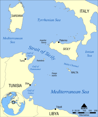
The Strait of Sicily is the strait between Sicily and Tunisia. The strait is about 145 kilometres (90 mi) wide and divides the Tyrrhenian Sea and the western Mediterranean Sea, from the eastern Mediterranean Sea. The maximum depth is 316 meters (1,037 ft). The island of Pantelleria lies in the middle of the strait.

<span class="mw-page-title-main">Alboran Sea</span> Westernmost portion of the Mediterranean Sea

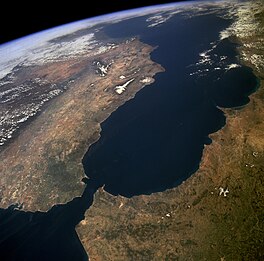
The Alboran Sea is the westernmost portion of the Mediterranean Sea, lying between the Iberian Peninsula and the north of Africa. The Strait of Gibraltar, which lies at the west end of the Alboran Sea, connects the Mediterranean with the Atlantic Ocean.

<span class="mw-page-title-main">Messinian salinity crisis</span> Drying-up of the Mediterranean Sea from 5.96 to 5.33 million years ago

The Messinian salinity crisis was a geological event during which the Mediterranean Sea went into a cycle of partial or nearly complete desiccation (drying-up) throughout the latter part of the Messinian age of the Miocene epoch, from 5.96 to 5.33 Ma. It ended with the Zanclean flood, when the Atlantic reclaimed the basin.

<span class="mw-page-title-main">Strait of Gibraltar crossing</span> Europe-Africa fixed link

The Strait of Gibraltar crossing is a hypothetical bridge or tunnel spanning the Strait of Gibraltar that would connect Europe and Africa. The governments of Spain and Morocco appointed a joint committee to investigate the feasibility of linking the two continents in 1979, which resulted in the much broader Euromed Transport project.

<span class="mw-page-title-main">Outline of oceanography</span> Hierarchical outline list of articles related to oceanography

The following outline is provided as an overview of and introduction to Oceanography.

<span class="mw-page-title-main">Camarinal Sill</span> Seafloor barrier between the Atlantic and Mediterranean

The Camarinal Sill is the sill separating the Mediterranean Sea and the Atlantic Ocean. This threshold is the shallowest seafloor pass between the Iberian Peninsula and Africa. It is located approximately 25 km west of the narrowest section of the Strait of Gibraltar and 20 km east of the Espartel Sill, at 35°56′N5°45′W, at a depth of 280 m.

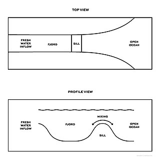
Estuarine water circulation is controlled by the inflow of rivers, the tides, rainfall and evaporation, the wind, and other oceanic events such as an upwelling, an eddy, and storms. Estuarine water circulation patterns are influenced by vertical mixing and stratification, and can affect residence time and exposure time.

The Spartel or Espartel Sill is one of the sills separating the Mediterranean Sea and the Atlantic Ocean. This threshold is the second shallowest seafloor pass between the Iberian Peninsula and Africa. It is located near the Strait of Gibraltar and the Camarinal Sill, at 35°55′N5°47′W, at a depth of −300 m. The deep, salty and dense waters of the Mediterranean must climb to that depth when flowing towards the Atlantic.

<span class="mw-page-title-main">Aquatic sill</span> A sea floor barrier of relatively shallow depth restricting water movement between oceanic basins

An aquatic sill is a sea floor barrier of relatively shallow depth that restricts water movement between benthic zones of an oceanic basin or lake bottom. There are roughly 400 sills in the Earth's oceans, covering 0.01% of the seafloor. A classic example is the Strait of Gibraltar Gateway between the Mediterranean sea and the Atlantic Ocean.

<span class="mw-page-title-main">Zanclean flood</span> Theoretical refilling of the Mediterranean Sea between the Miocene and Pliocene Epochs

The Zanclean flood or Zanclean deluge is theorized to have refilled the Mediterranean Sea 5.33 million years ago. This flooding ended the Messinian salinity crisis and reconnected the Mediterranean Sea to the Atlantic Ocean, although it is possible that even before the flood there were partial connections to the Atlantic Ocean. The re-connection marks the beginning of the Zanclean age which is the name given to the earliest age on the geologic time scale of the Pliocene.

<span class="mw-page-title-main">Mediterranean outflow</span>

The Mediterranean Outflow is a current flowing from the Mediterranean Sea towards the Atlantic Ocean through the Strait of Gibraltar. Once it has reached the western side of the Strait of Gibraltar, it divides into two branches, one flowing westward following the Iberian continental slope, and another returning to the Strait of Gibraltar circulating cyclonically. In the Strait of Gibraltar and in the Gulf of Cádiz, the Mediterranean Outflow core has a width of a few tens of km. Through its nonlinear interactions with tides and topography, as it flows out of the Mediterranean basin it undergoes such strong mixing that the water masses composing this current become indistinguishable upon reaching the western side of the strait.

References

  1. (Arabic : مضيق جبل طارق, romanized: Maḍīq Jabal Ṭāriq; Spanish : Estrecho de Gibraltar, Archaic: Pillars of Hercules)
  2. "Strait of Gibraltar | channel". Encyclopedia Britannica. Retrieved 2020-10-24.
  3. See Robinson, Allan Richard and Paola Malanotte-Rizzoli, Ocean Processes in Climate Dynamics: Global and Mediterranean Examples. Springer, 1994, p. 307, ISBN   0-7923-2624-5.
  4. Chisholm, Hugh, ed. (1911). "Gibraltar"  . Encyclopædia Britannica . Vol. 11 (11th ed.). Cambridge University Press. p. 938.
  5. "Google Books Ngram Viewer results "Strait of Gibraltar/Gut of Gibraltar"".
  6. See, for instance, Nato Medals: Medal for Active Endeavor Archived 2006-06-16 at the Wayback Machine , awarded for activity in the international water of the Mediterranean and STROG.
  7. Pamphlet of the Museum of the Castle of Guzman el Bueno, [El Ayuntamiento de Tarifa] accessed 16 November 2016.
  8. "Strait of Gibraltar - channel". Encyclopedia Britannica. 2009-04-14. Retrieved 2022-04-21.
  9. Strabo Geographia 3.5.5.
  10. "Migration Information Source – The Merits and Limitations of Spain's High-Tech Border Control". Migrationinformation.org. Retrieved 2011-07-15.
  11. "Limits of Oceans and Seas, 3rd edition" (PDF). International Hydrographic Organization. 1953. Retrieved 28 December 2020.
  12. De Mol, B., et al. 2012. "Ch. 45: Cold-Water Coral Distribution in an Erosional Environment: The Strait of Gibraltar Gateway", in: Harris, P. T.; Baker, E. K. (eds.), Seafloor geomorphology as benthic habitat: GEOHAB Atlas of seafloor geomorphic features and benthic habitats. Elsevier, Amsterdam, pp. 636–643.
  13. At the Miocene/Pliocene boundary, c. 5.33 million years before the present
  14. Cloud, P., Oasis in space. Earth history from the beginning, New York: W.W. Norton & Co. Inc., p. 440. ISBN   0-393-01952-7
  15. Johnson, Scott K. (2013-07-25). "Gibraltar might be the beginning of the end for the Atlantic Ocean". Ars Technica. Retrieved 2021-03-18.
  16. "Data Zone: Strait of Gibraltar". BirdLife. Retrieved 2019-02-23.
  17. Carrington, Damian (2018-09-27). "Orca 'apocalypse': half of killer whales doomed to die from pollution". The Guardian. ISSN   0261-3077 . Retrieved 2019-02-23.
  18. "Last of the Neanderthals". National Geographic. October 2008. Archived from the original on September 18, 2008. Retrieved 2009-12-29.
  19. Beevor, Antony (2006) [1982]. The Battle for Spain. Orion. ISBN   978-0-7538-2165-7.
  20. "Europe-Africa rail tunnel agreed". BBC News.
  21. "Tunnel to Connect Morocco with Europe". bluedoorhotel.com. February 17, 2012. Archived from the original on 2012-11-04.
  22. "Strait of Gibraltar underwater railway tunnel project coming back to life". Construction Review Online. 15 August 2021. Retrieved 6 October 2021.
  23. "Morocco, Spain discuss revival of fixed link project via Gibraltar Strait". The North Africa Post. 22 April 2021. Retrieved 6 October 2021.
  24. Alaoui, Mohamed (9 January 2021). "British-Moroccan undersea tunnel would connect Africa to Europe". The Arab Weekly. Retrieved 6 October 2021.
  25. Soto-Navarro, Javier; Criado-Aldeanueva, Francisco; García-Lafuente, Jesús; Sánchez-Román, Antonio (2010-10-12). "Estimation of the Atlantic inflow through the Strait of Gibraltar from climatological and in situ data". Journal of Geophysical Research. 115 (C10): C10023. Bibcode:2010JGRC..11510023S. doi: 10.1029/2010JC006302 . hdl: 10630/29356 . ISSN   0148-0227.
  26. Paterson, Lawrence (2007). U-Boats in the Mediterranean 1941–1944. Chatham Publishing, pp. 19 and 182. ISBN   9781861762900
  27. "U-boat war in the Mediterranean". uboat.net. Retrieved 2011-07-15.
  28. Wesson, J. C.; Gregg, M. C. (1994). "Mixing at Camarinal Sill in the Strait of Gibraltar". Journal of Geophysical Research . 99 (C5): 9847–9878. Bibcode:1994JGR....99.9847W. doi:10.1029/94JC00256.
  29. 1 2 Víctor Luis Gutiérrez Castillo (April 2011). The Delimitation of the Spanish Marine Waters in the Strait of Gibraltar (PDF) (Report). Spanish Institute for Strategic Studies. Retrieved 5 July 2019.
  30. Tremlett, Giles (13 July 2002). "Moroccans seize Parsley Island and leave a bitter taste in Spanish mouths". The Guardian .
  31. Rothwell, Donald R. (2009). "Gibraltar, Strait of". Oxford Public International Law. Oxford University Press. doi:10.1093/law:epil/9780199231690/e1172. ISBN   9780199231690 . Retrieved 6 July 2019.
  32. "Atlantropa: A plan to dam the Mediterranean Sea". Xefer blog. 16 March 2005. Retrieved on 13 August 2012.