A territorial dispute or boundary dispute is a disagreement over the possession or control of land between two or more political entities.
A territorial dispute or boundary dispute is a disagreement over the possession or control of land between two or more political entities.
Territorial disputes are often related to the possession of natural resources such as rivers, fertile farmland, mineral or petroleum resources although the disputes can also be driven by culture, religion, and ethnic nationalism. Territorial disputes often result from vague and unclear language in a treaty that set up the original boundary.
Territorial disputes are a major cause of wars and terrorism, as states often try to assert their sovereignty over a territory through invasion, and non-state entities try to influence the actions of politicians through terrorism. International law does not support the use of force by one state to annex the territory of another state. The UN Charter states, "All Members shall refrain in their international relations from the threat or use of force against the territorial integrity or political independence of any state, or in any other manner inconsistent with the Purposes of the United Nations."
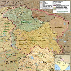
In some cases in which the boundary is not demarcated, such as the Taiwan Strait, and Kashmir, the parties involved define a Line of Control, which serves as the de facto international border.

Territorial disputes have significant meaning in the international society, both by their relation to the fundamental right of states, sovereignty and also because they are important for international peace. International law has significant relations with territorial disputes because territorial disputes tackles the basis of international law; the state territory. International law is based on the persons of international law, which requires a defined territory, as mentioned in the 1933 Montevideo Convention on the Rights and Duties of States.
Article 1 of the Montevideo Convention declares that "a person of international law should possess the following qualifications: (a) a permanent population; (b) a defined territory; (c) government; and (d) capacity to enter into relations with other States" [1]
Also, B. T. Sumner's article mentions, "In international law and relations, ownership of territory is significant because sovereignty over land defines what constitutes a state." [2]
Therefore, the breach of a country's borders or territorial disputes pose a threat to a state's very sovereignty and the right as a person of international law. In addition, territorial disputes are sometimes brought to the International Court of Justice, as was the case in Costa Rica and Nicaragua (2005). [3] Territorial disputes cannot be separated from international law, whose basis is on the law of state borders, and their potential settlement also relies on international law and the Court.
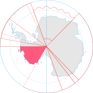
Terra nullius is a Latin expression meaning "nobody's land". Since the nineteenth century it has occasionally been used in international law as a principle to justify claims that territory may be acquired by a state's occupation of it. There are currently three territories sometimes claimed to be terra nullius: Bir Tawil, four pockets of land near the Danube due to the Croatia–Serbia border dispute, and parts of Antarctica, principally Marie Byrd Land.

Serranilla Bank is a partially submerged reef, with small uninhabited islets, in the western Caribbean Sea. It is situated about 350 kilometres (220 mi) northeast of Punta Gorda, Nicaragua, and roughly 280 kilometres (170 mi) southwest of Jamaica. The closest neighbouring land feature is Bajo Nuevo Bank, located 110 kilometres (68 mi) to the east.

Bajo Nuevo Bank, also known as the Petrel Islands, is a small, uninhabited reef with some small grass-covered islets, located in the western Caribbean Sea at 15°53′N78°38′W, with a lighthouse on Low Cay at 15°51′N78°38′W. The closest neighbouring land feature is Serranilla Bank, located 110 kilometres to the west.
The status of territories captured by Israel is the status of the Gaza Strip, the West Bank, the Golan Heights, and the Sinai Peninsula, all of which were captured by Israel during the 1967 Six-Day War.

The Malaysia–Singapore border is an international maritime border between the Southeast Asian countries of Malaysia, which lies to the north of the border, and Singapore to the south. The boundary is formed by straight lines between maritime geographical coordinates running along or near the deepest channel of the Straits of Johor.
Territorial disputes of Nicaragua include the territorial dispute with Colombia over the Archipelago of San Andrés, Providencia and Santa Catalina and Quita Sueño Bank. Nicaragua also has a maritime boundary dispute with Honduras in the Caribbean Sea and a boundary dispute over the Rio San Juan with Costa Rica.
The United States has land borders with only Canada and Mexico, both of them long. Its has maritime boundaries with many countries due to its extensive exclusive economic zone (EEZ). All of its maritime borders with Canada are at least partially disputed, and its territorial claims on three Caribbean islands are disputed.

The Belizean–Guatemalan territorial dispute is an unresolved territorial dispute between the states of Belize and Guatemala, neighbours in Central America. During the late 1600s and throughout the 1700s, Britain and Spain signed several treaties regarding territories in the Americas. Both nations agreed that the territory of modern-day Belize was under Spanish sovereignty though British settlers could use the land, in specific areas and for specific purposes. The area was never fully under British or Spanish rule at this time and the British settlers continually expanded far past the boundaries set by the treaties. When the Spanish Empire fell, Guatemala said that it inherited Spain's sovereign rights over the territory. Since independence Guatemala has claimed, in whole or in part, the territory of Belize.

Colombia–Nicaragua relations entail the diplomatic relations between the Republic of Colombia and the Republic of Nicaragua. The relationship between the two Hispanic American countries has evolved amid conflicts over the San Andrés y Providencia Islands located in the Caribbean sea close to the Nicaraguan shoreline and the maritime boundaries covering 150,000 km2 that included the islands of San Andrés, Providencia and Santa Catalina and the banks of Roncador, Serrana, Serranilla and Quitasueño as well as the 82nd meridian west which Colombia claims as a border but which the International Court has sided with Nicaragua in disavowing. The sea around the archipelago has been under Colombian control since 1931 when a treaty was signed during US occupation of Nicaragua, giving Colombia control over the area. Both nations are members of the Association of Caribbean States, Community of Latin American and Caribbean States, Organization of American States, Organization of Ibero-American States and the United Nations.

The Case Concerning the Territorial Dispute [1994] is a public international law case decided by the International Court of Justice (ICJ) concerning the border between the Libyan Arab Jamahiriya and the Republic of Chad. The case was put forward to settle a territorial dispute between the two countries, particularly over a strip of land called the Aouzou Strip which Libya had occupied since the Chadian–Libyan War, and an area which Libya called the Libya–Chad Borderlands or simply the Borderlands. Libya's claim of the Borderlands included parts of the regions of Borkou, Ennedi and Tibesti, including parts of the localities of Erdi, Kanem and Ounianga. It also covered the Chadian region of B.E.T. minus northern Kanem.
A sovereign state is a state that has the highest authority over a territory.

The Nicaragua–Costa Rica San Juan River border dispute was a series of periodical conflicts between the Costa Rica and Nicaragua over the correct delimitation of their common border at its east-end, and the interpretation of the navigation rights on the San Juan River established in the Cañas-Jerez Treaty of 1858.

A maritime boundary is a conceptual division of Earth's water surface areas using physiographical or geopolitical criteria. As such, it usually bounds areas of exclusive national rights over mineral and biological resources, encompassing maritime features, limits and zones. Generally, a maritime boundary is delineated at a particular distance from a jurisdiction's coastline. Although in some countries the term maritime boundary represents borders of a maritime nation that are recognized by the United Nations Convention on the Law of the Sea, maritime borders usually serve to identify the edge of international waters.

The Chad–Libya border is 1,050 km in length and runs from the tripoint with Niger in the west, to the tripoint with Sudan in the east.